With my passport firmly in my pocket, I arrived on the Yucatan Peninsula in southeast Mexico. The peninsula stretches out into the Gulf of Mexico and the Caribbean Sea, and it's divided into a few states, with Yucatan, Quintana Roo, and Campeche being the major players. Belize is also part of the picture, located at the peninsula's southern end, bordering Mexico.
One thing that makes the Yucatan Peninsula stand out is its unique geological formation. The limestone that dominates the landscape has created a huge network of underground rivers and sinkholes called cenotes. These cenotes support a wonderful aquatic ecosystem and are home to blind fish, crustaceans, and other creatures that have adapted to these subterranean environments.
But the peninsula's location is another factor that sets it apart. It's situated right at the intersection of two major biogeographical regions - the Nearctic and the Neotropical. The Nearctic region is known for its freezing winters and temperate summers. The plants and animals in this region either hibernate or head south when winter rolls around. Meanwhile, the Neotropical region is characterized by its warm, tropical climate and heavy rainfall, which creates lush rainforests and other dense ecosystems. This unique meeting point of two regions has led to an incredible diversity of flora and fauna that thrive in this environment. Many species, such as the Yucatan spider monkey and the Cozumel raccoon, are endemic to this area.
Another famous spot on the Yucatan Peninsula is the Chicxulub Crater. This massive crater was formed by an asteroid impact around 66 million years ago, and it's believed to have been the cause of the extinction of the dinosaurs. The crater is about 110mi (180km) wide and 12mi (20km) deep, with half of it on the peninsula and the other half submerged underwater. Clusters of cenotes dot the crater's border, indicating that a water basin was inside the crater after the impact.
The Yucatan Peninsula was home to many ancient civilisations, the most prominent and longest-lasting being the Maya. Emerging around 2000 BC, this civilisation consisted of various tribes that spoke different languages in the Mayan language family. They prospered until the 16th century when the Spanish arrived, marking the start of the colonial era.
The Maya contributed significantly to advanced writing, mathematics, and astronomical systems. They are also associated with constructing the colossal, stepped pyramids, such as the famed Kukulcan Pyramid (aka El Castillo) in Chichen Itza.
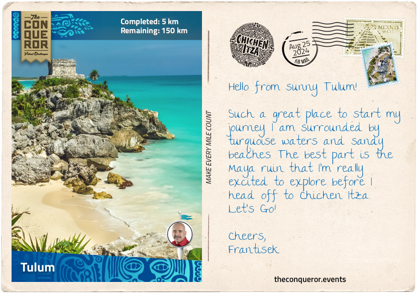
I started this journey in Tulum, a coastal Maya ruin that sits atop a cliff, overlooking stunning beaches and the turquoise water of the Caribbean Sea. Tulum was a bustling Maya city between the 13th and 16th centuries. The name "Tulum" means "wall" in the Yucatec Maya language and refers to the fortified walls that used to surround the city. Some people believe it may have also been called Zama at some point, which means "City of the Dawn" because it faced the sunrise.
There are some amazing highlights at Tulum, including the El Castillo (The Castle) temple, the Temple of Frescoes and the Temple of the Descending God. El Castillo is perched on a cliff and might have been used as a lighthouse guiding ships into the port. The Temple of the Frescoes is a two-storey structure with well-preserved murals on its façade. It was used to track the movement of the sun. The Temple of the Descending God features a sculpture of a Maya deity descending a staircase. It is identified as the god of fertility and agriculture and one of the most recognisable images in Maya art.
After the Spanish conquest, Tulum was abandoned and forgotten until the 20th century, when it was rediscovered and restored. Nowadays, it's a major tourist destination and one of the best-preserved coastal Maya sites.
Next up, I'm heading west to check out Coba, another ancient Maya city.
km od začátku : 0047
Coba
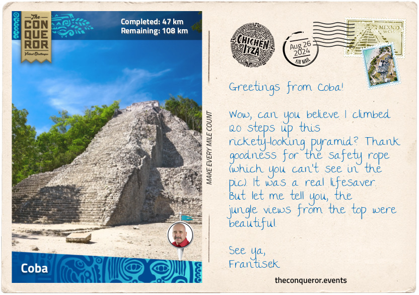
Here I am in Coba, staring up at one of the tallest Maya structures on the peninsula, the temple pyramid called Ixmoja. It is 138ft (42m) tall and part of the Nohoch Mul complex of pyramids. As I contemplate the effort needed to ascend, I am reminded that it is the only climbable pyramid on this route and, therefore, an experience not to be missed. The top affords incredible views of the surrounding jungle, and I hope to catch a glimpse of Chichen Itza in the distance.
Before I start this climb, let me tell you about its history. Archaeological evidence indicates that Coba was initially settled somewhere between 50 BC to 100 AD. The city flourished from 600 to 900 AD and became one of the most powerful cities in the region, with a thriving population of around 50,000 people. During its peak, Coba was ruled by a series of kings known as the "k'uhul ajaw" ("divine lord"). The kings believed they were closely related to the gods and acted as mediators between the gods and the people. They oversaw the construction of grand buildings and led elaborate religious ceremonies.
One of the unique features of Coba was its system of elevated stone roads, called sacbeob that connected the city to smaller settlements and outlying structures. The sacbeob were a vital part of the Maya trade and communication system, with the longest sacbe stretching westward over 62mi (100km), connecting Coba to the site of Yaxuna. The sacbeob were typically 10-30ft wide (3-9m) and elevated above ground about 3ft (1m), allowing people to walk or transport goods above the dense jungle floor. The word sacbe comes from the Mayan language, meaning "white road," and it refers to the limestone stucco placed over the stone and rubble fill, giving the road its white appearance. More than 50 sacbeob have been discovered in and around Coba, illustrating the importance and influence of the city.
Coba's name is believed to mean "waters stirred by the wind", which is fitting considering its proximity to Lake Coba and Lake Macanxoc. Encircled by reeds, Lake Coba is known for lurking crocodiles, and while a zip line crosses a portion of the lake, it would be wise to avoid landing in the reeds.
Southeast of the Nohoch Mul and past Lake Macanxoc is the Macanxoc Group. It is made up of three large buildings that surround a central courtyard. It is thought that the buildings were used as an administrative centre. A number of restored stelae can be found here, including Stela 1, a 13ft (4m) tall limestone monument. It features the image of one of the ruling kings and a lengthy text containing over 300 glyph blocks that describe historical events. Unfortunately, the carvings on the stelae have faded extensively due to the poor quality of the stone and insufficient preservation efforts. As a result, gaining knowledge from these carvings has been very difficult.
Let's go back to Ixmoja, the pyramid I mentioned earlier. Ixmoja was built from a series of platforms stacked up on one another. The temple sat on the final platform reached by climbing 120 steep steps. The million-dollar question is: how did the kings manage to climb those stairs? Did they find some more efficient form of climbing, like an elaborate staircase or a ramp system? There's little archaeological evidence of this feat. But for me, it looks like I’ll be climbing it one step at a time. Luckily there’s a thick rope in the middle for safety. Here I go!!
km od začátku : 0101
Cenote Suytun
That was a mighty climb up the Ixmoja pyramid but totally worth the panoramic views of the jungle canopy. Working up a sweat, I craved a refreshing dip to cool off. Fortunately, the region between Coba and Valladolid is teeming with cenotes, each with its distinct features. With so many options at my disposal, the hardest part was deciding which one to choose.
Cenotes are natural swimming holes or sinkholes formed by the collapse of porous limestone bedrock, revealing the underlying groundwater. The water is often crystal clear and refreshing, perfect for snorkelling and swimming. Some cenotes will have intricate cave systems, underwater rock formations, and even submerged trees and vines. Cenotes are often surrounded by lush vegetation, creating a visually appealing landscape.
Southwest of Coba is Cenote Multun-Ha tucked away in a beautiful chamber about 59ft (18m) underground. Access is via a circular staircase leading to a wooden platform that extends over the water. A portion of the cavern's roof collapsed, opening the cenote to sunlight filtering in. The deepest part is about 115ft (35m) and accessible only to certified scuba divers.
Nearby is Cenote Choo-ha, where the clear water lets the viewer see fish swimming. The cavern is adorned with stalactites and stalagmites that have formed over thousands of years. A mere 787ft (240m) away is Cenote Tankach-Ha, located in a cave system with a platform for jumping into the water. All three cenotes are in dense jungles where beautiful orchids and bromeliads grow.
North of Coba is Cenote Kuxtal which has been said to have healing properties. But what makes this cenote fun is the swing hanging just above the water's surface and the 26ft (8m) jumping platform for the adventurous souls looking for a thrill.
Not far from Valladolid is Cenote X'ux Ha, nestled below a massive limestone dome and home to blind fish who have adapted to the dark environment of the cave. The first descent via stairs leads to a platform offering a 180-degree view of the cenote. From here, a further 82ft (25m) descent reaches the bottom of the cenote. A natural hole at the top of the cathedral-like dome filters light into the cavern, illuminating the clear water. The yellowish-green walls of the cavern provide a stunning contrast to the cobalt colour of the water.
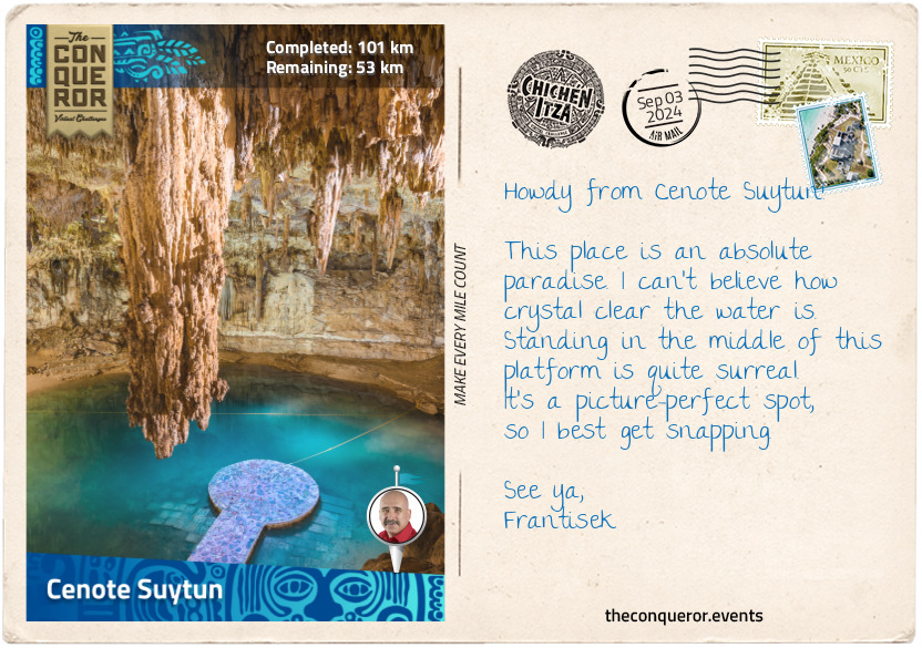
The last of the cenotes in this area is Suytun, known for its impressive stalactite formations that hang down from the ceiling. A platform built in the middle of the cenote provides a perfect spot for that Instagram-worthy photo. This is where I decided to take my swim, have a cool refreshment and take some time to rest.
km od začátku : 0108
Valladolid
Dried off and refreshed, I arrived in Valladolid, a charming city founded in 1543 by the Spanish conquistador Francisco de Montejo. It was named after the Spanish city of the same name. Its historic centre is filled with beautiful pastel-coloured buildings. At its heart is the imposing Templo de San Servacio, a 16th-century Spanish colonial church with two soaring towers.
The city was built in a grid pattern typical of a Spanish colonial town, with a central square and streets radiating out from it. Valladolid was founded on the ruins of Zaci, an ancient Maya settlement that occupied the area from around 500 AD. Zaci was built around a cenote, which the Maya considered sacred and used for religious rituals, bathing and drinking water. The Zaci buildings were dismantled, and the stones were reused to build Valladolid. The Zaci cenote, located near the central square, remained an important feature of the town and was used as a water source until the early 20th century. Today it is a swimming hole surrounded by poplars, ferns, philodendrons and orchids.
I had a delightful experience visiting Casa de los Venados, a museum located in a private home owned by a couple from Chicago who have been collecting Mexican folk art for years. In the early 2000s, they decided to move to Valladolid and create a custom-made home that would allow them to share their collection year-round. With the help of experts in Mexican folk art, the collection has quickly grown to over 3,000 pieces of museum-quality art.
The house is built around a large patio and central pool. The interior is tastefully decorated with incredible works of art bursting with color, texture, and intrigue. Unsurprisingly, the house and its architect have won several architectural awards.
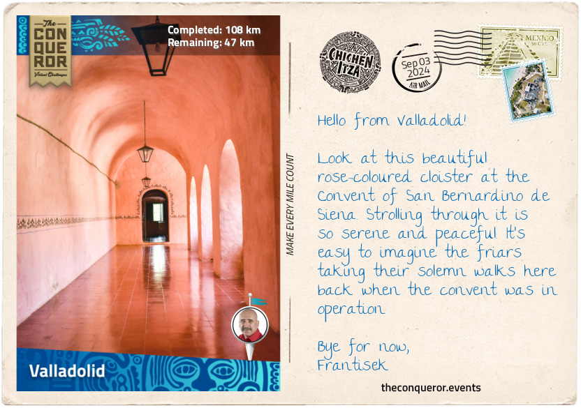
Located southwest of Valladolid's city centre is the Convent of San Bernardino de Siena. This historical landmark dates back to the 16th century. Built by Franciscan monks, the convent served as a religious centre of the community for many years. A walkway lined with ceibas trees, planted by the friars, leads to the "Esquina de las Cinco Calles" or "Corner of the Five Streets". It is a nod to the streets that radiate from the convent and connect it with the surrounding community. The convent's grand scale features intricate details on its façade, a central courtyard enclosed within a rose-coloured cloister, frescoes on its chapel's interior and a beautifully carved wooden altarpiece. Today, the convent is a museum and cultural centre.
km od začátku : 0137
Maya Cuisine
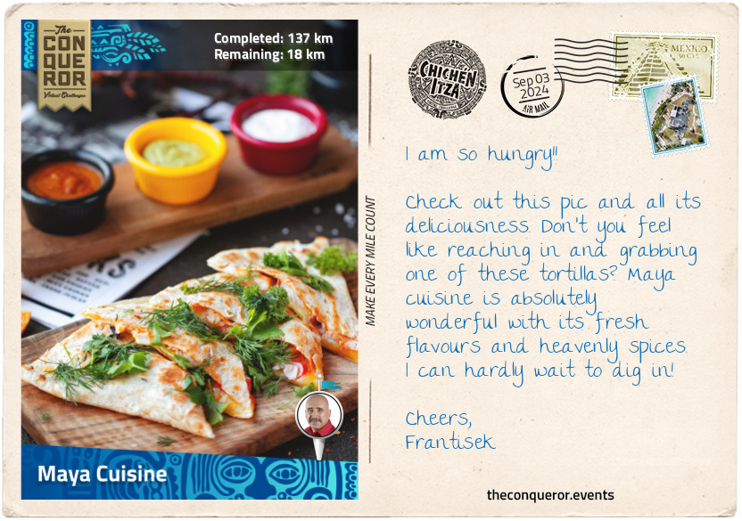
Let me tell you a little about Maya cuisine. As an ancient civilization, Maya cuisine has naturally developed over thousands of years. The result is a beautifully rich culinary tradition with complex flavors, unique ingredients, and special techniques passed down through the generations.
One of the most distinctive features of Maya cuisine is the use of maize (corn), which is considered a sacred plant by the Maya people. Corn is used for making dishes like tortillas, tamales, and sweetened corn-based drinks.
While corn was the most important crop for the Maya, they also cultivated other staple crops like beans and squash. These were often grown together in the same fields, a practice known as "the three sisters". They also grew avocados, papayas, bananas, guavas, tomatoes, and chili peppers. Oregano, vanilla, and coriander were raised for seasoning and flavoring, while amaranth and sunflowers were planted for their edible seeds.
Cacao beans were carefully cultivated and grown exclusively in sacred groves because the Mayans believed the beans were a gift from the gods. Once harvested, the beans were ground up with spices and served as a chocolate drink for the ruling class. The beans were so highly valued that they were often used as currency.
Eating meat was uncommon, as the Maya were primarily farmers and fishermen. However, deer, guinea pig, iguana and armadillo, to name a few, were sometimes hunted and eaten during festivals, as well as fish, lobsters and shrimps.
Besides the usual grilling and steaming, there was a pretty cool traditional cooking method called pit cooking, where they wrapped the food in banana leaves, buried it in a hole, and cooked it very slowly with hot rocks.
While Maya dishes have evolved and modified to suit modern tastes, here are a few delicious dishes enjoyed today:
Tamales: corn husk-wrapped bundles filled with corn flour dough and meat or vegetables cooked in chilli, garlic and cumin sauce.
Guacamole: crushed avocados with chilli, garlic, cilantro, onions, and lime.
Chilmole: a traditional meat-based stew seasoned with red-dried chili peppers, garlic, cumin, and other spices.
Traditional Maya breakfast: scrambled eggs, a side of black beans, queso blanco (white cheese), and warm yellow corn tortillas, finished with a hot coffee made from local beans.
Is anybody hungry? I sure am. What is your favourite Maya or Yucatan dish?
km od začátku : 0153
Chichen Itza
I have finally arrived at the fabulous archaeological site of Chichen Itza, one of the greatest Maya cities and a centre of political and economic power. It was constructed around the 6th century and flourished until the 13th century when it was abandoned for unknown reasons. The name "Chichen Itza" means "at the mouth of the well of the Itza", referring to the "Cenote Sagrado" ("Sacred Cenote"), a sinkhole that was used for sacrificial offerings to the rain god Chaac.
As I explored the grounds, I first wandered through the Great Ball Court, where the Mesoamerican ballgame, called pitz in Classical Maya or pok-a-tok in English, was played with a solid rubber ball. Chichen Itza has 13 ballcourts, but the Great Ball Court is the largest and best-preserved. It measures 551ft (168m) long and 230ft (70m) wide. The parallel platforms flanking the court have rings carved with intertwined feathered serpents high up in the center of each wall. The game's objective is to hit the ball through the rings using only the hips, shoulders, elbows, knees, and occasionally the head to keep the ball in play. Essentially hands and feet were not permitted. The game was very symbolic to the Mayans and carried various meanings, such as the struggle between good and evil, life and death, wealth and power, politics, and warfare.
At the end of the ballcourt, I swung east, passing the Platform of Eagles and Jaguars, and the Platform of Venus, heading to the Temple of the Warriors. The temple is an amazing complex of a stepped pyramid surrounded by 200 round and square columns on its south and west sides. The square columns are carved in bas-relief, depicting warriors. A broad stairway leads to the top. Before the main entrance is Chac Mool, a sculpture of a reclined figure resting on its elbows and legs folded, supporting a plate on its stomach. Its head is turned 90 degrees from the front. It is believed to have been used in religious rituals and offerings to the gods, but scholars continue to debate its exact significance.
The grand finale of this journey is an exploration of the most impressive and iconic structure in Chichen Itza, the Kukulcan Pyramid, also known as El Castillo (The Castle). Built between the 8th to 12th centuries, this massive, nine-level, stepped pyramid served as a temple to the feathered serpent god, Kukulcan. It rises 98ft (30m) high with four sides, each with 91 steps and one more on top that contains a temple, making a total of 365 steps, one for each day of the year. The pyramid was constructed to align with the sun's movements, creating a fascinating effect during the spring and autumn equinoxes when the shadow of a snake slithers down the side of the pyramid.
Inside the main structure is a smaller pyramid, likely from an earlier Maya period, that contains a third pyramid within its walls. The pyramids were built on top of a cenote that connects to an underground river system. The second pyramid can be accessed via a dark and narrow stair climb. It contains the sculpture of a Chac Mool and a jaguar throne still in its original condition, including the jade-encrusted eyes, which kings used to communicate with the gods. The kings would sit on the throne and watch sacrifices made to the deity Chaac. Behind the throne embedded in the wall are bones thought to belong to ancestors.
The Kukulcan Pyramid continues to surprise as it slowly reveals its inner secrets. Yet, when Chichen Itza was abandoned and the jungle reclaimed the site, this grand and beautiful structure almost disappeared completely beneath the vegetation. In an 1892 photo, only the temple and parts of the stairway on one side were visible. Enormous restoration efforts were undertaken in the 1920s and 1930s when several buildings were reconstructed, including the Kukulcan Pyramid. Today, Chichen Itza is designated a UNESCO site and one of the Seven Wonders of the World.
There is so much more to learn and see here. I can see why archaeologists keep coming back to study this incredible site. However, I will end my journey for now and bid you farewell.