I have arrived at the Southern terminus of the Continental Divide Trail. Starting right on the Mexican border near the city of Chihuahua, I am about to take my first steps as I follow this National Scenic Route 2,865 miles (4610 km) heading NOBO (northbound) through five states, across deserts, mountains, forests and glaciers until I arrive at the Canadian border.
This is a thru-hike, meaning I won’t be breaking the trip up or tackling a single section, but going the whole way. The journey should take me about 5 months, so I’ve started in early Spring. That way, when I arrive at the Canadian border, I’ll have balmy summer weather to look forward to.
The Continental Divide Trail (CDT) is the youngest of the Triple Crown, the three great hiking trails that span the USA from north to south. The other routes, the Appalachian Trail and the Pacific Crest Trail, were established earlier. But don’t let its relative youth fool you; the CDT has just as much character, heritage, and hiker culture as its elder sisters. First conceptualised in 1962 during the administration of President Lyndon B. Johnson, it was designed to follow the crest of mountains that bisect the North American continent into two watersheds. As I walk, the rivers flowing to my west will empty into the Pacific, those to my East into the Atlantic, forming the Continental Divide.
The trail was not completed until 1977, and its creation was the result of the cooperation of government agencies, forest rangers, and passionate hikers. The trail is maintained thanks to the efforts of the Continental Divide Coalition, the U.S. Forest Service, and the National Park Service, as well as an army of dedicated volunteers. Hard work and government funding keep this achievement in working order, available for everyone to enjoy.
The trail is one of the best ways to appreciate the vast natural diversity of the USA. Along the way, I’ll pass through the longest continuous wilderness corridor in the States and some of the world's most pristine and beautiful landscapes. Over 400 species of mammals, 1500 different species of plants, and countless reptiles and insects are found along the way as the natural biomes and ecosystems change from desert to forest, to mountain, to tundra.
The trail, with its many, many steep ascents, is also said to be the most challenging of the Triple Crown, and much of it is poorly marked; I expect in some sections I’ll have to become a trailblazer, bushwacking through the undergrowth. I’m going to have to clamber through the trees, ford the rivers, and scramble up the mountains. I’ll have to become a true pioneer if I’m to arrive at the end of the trail.
So, that’s it, some preamble! Now, I’m standing in the hot sun next to the Crazy Cook Monument, which marks the start of the trail. The desert stretches out before me now, an endless flat expanse, and it seems impossible that my legs will carry me from this sun-baked wilderness to the pines and glaciers of the north. Well, nothing to do now but apply some sunscreen, hoist my backpack on my back, find a good sturdy stick to support me and begin the trip. Away we go!
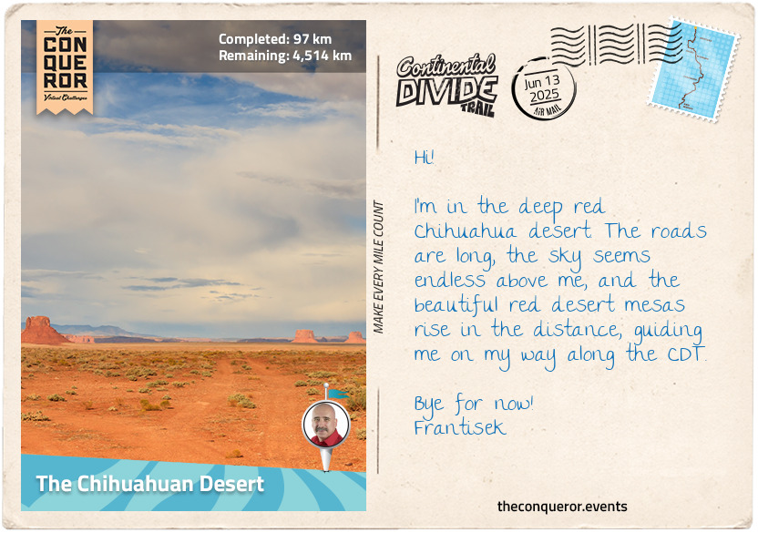
km od začátku : 0097
The Chihuahuan Desert
This first section of the hike took me through the baking Chihuahuan desert. Named after the nearby region in Mexico and having nothing to do with the angry little dog breed, this desert forms some of the most perilous miles of the journey. The distances are huge, the landscape is foreboding, and water is scarce. This section requires a lot of preparation. Luckily, solidarity among hikers is strong, and the trail in this section is dotted with caches of water left by Trail Angels, kind souls who leave supplies out for fellow hikers. The ground is rocky and sandy, and the plants that thrive here are scruffy, hardy things that evolved to survive in this harsh environment. The sun beats down, the road stretches into the distance.
But life finds a way, and just below my feet, I found one of the desert’s most fascinating residents: The Gila monster - a large lizard with a warty black and yellow hide. The Gila monster is most famous as one of the world’s few venomous lizards, possessing glands that produce dangerous hemotoxin. Unlike snakes, which inject their venom through their fangs, Gila monsters actually ‘chew’ the venom into their victim using grooves in their teeth. Luckily for me, the lizard only uses its powers for self-defence and bites, though incredibly painful, are rarely fatal for humans. In fact, the Gila has eased the lives of thousands, as its venom contains a compound called exendin-4, which is synthesised into the drug exenatide, used to treat type-2 diabetes. I saluted the Gila as he crawled on by, thanking him for his little service to humanity.
With the Gila gone, the loneliness of the desert began to set in again. Thru-hikers like myself are a rare breed, with only about 400 of us attempting to cross the trail every year. The vast distances in this section mean that it can be hours or even days before meeting another soul, allowing a lot of time for thinking. I mull over the journey ahead, wondering what challenges I’ll overcome, what setbacks I’ll endure, and how I’ll be changed at the end.
km od začátku : 0209
The Big Hatchet Mountains
Coming out of the desolate flatness of the Chihuahua desert, my legs began to ache as I entered the Big Hatchet Mountains. Here, the trail followed a pass through the peaks, winding through the steep, dramatic ridgelines.
The Big Hatchet Mountains are truly remote; these are the least visited mountains in the whole of the USA, and there are no nationally maintained trails here, save the Continental Divide. Something is disconcerting about this, as I’ve heard there’s dangerous wildlife. When I pitch my tent to sleep, I’m reminded of old cowboy movies, of those scenes where our hero settles down for the night, only to discover a rattlesnake in his sleeping bag. I make sure to check everything thoroughly, and every time I sit down for a rest, I listen out for that sinister buzz, an angry rattlesnake’s warning.
Another worrying fact is that this area is famous for its cougars, or mountain lions. As the USA’s only big cat, she enjoys an iconic status as a symbol of the North American wilderness. I can’t help wondering whether one is following me, stalking this hiker along the rocky passes of the Hatchets, its soft paws inaudible to my human ears. I began to quicken my pace, eager to reach safety at tonight’s rest spot, the historic town of Silver City.
I arrived in town in the early evening after following the dirt tracks that led in from the desert. This is the first major resupply town on the route, and I was grateful for a chance to rest, resupply and sleep in a bed for a change.
Silver City is a lovely little place, laid-back and friendly, full of souvenir shops, galleries, cafes and most importantly, a good grocery store to replenish my supplies. The town itself is historic. Once an Apache campground, it was settled by American prospectors in the 1870s, who came looking for silver in the nearby canyons. Today, it has some beautiful heritage houses and old churches, as well as a nice little park, which I spent the evening in, watching the deep red New Mexico sun set beneath the hills.
km od začátku : 0372
Gila National Forest
Leaving Silver City, I began to notice the first isolated copses of trees dotting the desert. I felt my legs ache as I headed uphill, and as the incline grew, the air got a little cooler, and the vegetation became lusher and greener. Soon, the little isolated copses of trees got larger and thicker until they formed the forest. With that appeared that most precious of commodities in New Mexico - shade! And then, as I heard the telltale rush of a river nearby, I found there was water!
I had arrived in the Gila National Forest, a beautiful and remote stretch of woodland dominated by conifers, with majestic Ponderosa pines lining the tops of the hills and the valleys full of aspens, oaks, and junipers. Flowers and ferns lined the soft pine-needle-strewn undergrowth, and songbirds flitted between the trees.
I noticed a hummingbird hovering next to the bright red flowers of an Indian paintbrush bush. From its burnt sunset-coloured plumage and white throat-patch, I identified it as a rufous, one of the most interesting species in this sweet order of bee-sized birds.
The rufous is tiny, growing to about 3 in (8 cm) in length, with a wingspan of about 4 in (10 cm). Even compared to other hummingbirds, it’s small. But what it lacks in size, it makes up for in tenacity. Famous among birders for its aggression, the rufous will often bully other, bigger hummingbirds, fighting them for access to flowers. If it’s successful, it will feed on the nectar, hovering next to the flowers thanks to the incredible speed of its wings, which beat 75 times a second (and over 200 times a second during courtship).
They also follow one of the longest migration paths in the animal kingdom. Each year, they travel 4000mi (6437 km) - twice across the entire western United States, from their wintering patches in sunny Mexico to their breeding grounds in Canada. Almost makes my thru-hike seem like a walk in the park.
I bade the hummingbird good luck on its journey, then came out of the forest and up through the red sandstone mesas and canyons that lay on its outskirts. I crossed a small spring stream and headed uphill until I arrived at the Gila Cliff Dwellings, a series of stone houses built into a cliff’s alcove by the Mogollon people about 700 years ago (see the Gila Cliff Dwellings local spot on your map nearby for more information an a picture gallery).
After exploring the streets and houses of the national monument, I headed through the lush canyons around the Gila River until the trees started to thin out again. Soon, I was back among the cacti, in the hot, shadeless desert, the last stage of my journey before arriving at a place named Pie Town, famous for, you guessed it, its pie shops.
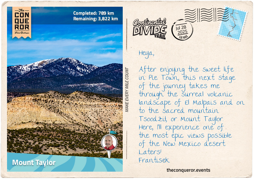
km od začátku : 0789
Mount Taylor
I arrived in Pie Town in the early afternoon, planning my walk to have enough time to visit this hospitable little spot. Pie Town is famous for its pies, of course, and after a week or so of porridge sachets, energy bars and instant coffee, I was looking forward to a warm dessert topped with rich vanilla ice cream, served with a cup of fresh, strong, real coffee.
Hikers need about 5000-7000 calories a day when tackling the Continental Divide, so I made sure to really treat myself when I arrived at the Pie-o-Neer pie shop. I ordered a cherry pie and a cup of coffee. The perfect flaky pastry crumbled underneath my fork as the cherries, in their ruby-red syrup, mixed with the white ice cream.
After a night spent in a hotel in town, I hitched my backpack once again and set off into the wilderness. The landscape here returned to the rugged, rocky barrenness of the desert, with only the red sandstone bluffs and mesas to keep me company. I walked in their shadow until I began to notice all kinds of strange rocky formations all around. I’d arrived at the El Malpais National Monument.
This area is described by the US National Park Foundation as the land of frozen fire. It’s the remains of a volcanic plain that formed hundreds of millions of years ago when this part of New Mexico was a volcanic zone. I walked through the remains of this ancient volcano, paying mindful attention to how the colours of the landscape changed as the day aged — from the soft peachy hues of the morning, and the deep golden yellows of midday, to the rich bronze of sunset, and the light blues of dusk. As the inky blackness of night set in, I set up my camp and lay beneath the vast New Mexico sky, threaded through with more stars than I’d ever seen on any night before.
The next day, I began to sense another incline and rejoiced as trees (and shade!) began to appear once again. I had reached the slopes of Mount Taylor. This is a sacred place to the local Navajo Nation, who refer to it as Tsoodził, or the Turquoise Mountain, as it marks one of the cardinal points and boundaries of the tribe’s traditional homeland, the Dinétah. The mountain is a challenging ascent, reaching 11,305 ft (3,446 m) in elevation. I struggled up the slopes, enjoying the beautiful pine forest, but sweating with my big backpack weighing me down. When I eventually reached the top, the endless blue sky stretched out, and below was the grandeur of the New Mexico desert, the CDT laid out for me like a map.
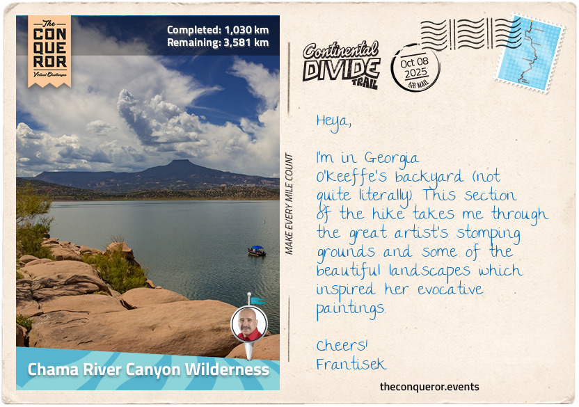
km od začátku : 1030
Chama River Canyon Wilderness
I've begun the last stage of my New Mexico journey as I wander through the Chama River Canyon Wilderness, home to one of the USA's most important modernist painters, Georgia O'Keeffe (1887-1986). I've always enjoyed O'Keeffe's paintings; they first appear to your eye almost as abstract forms until you realise you're looking at a flower, a mountain or a sunset. With her sumptuous colours and the fluid contours of her brushstrokes, she painted her feelings into nature, infusing her emotional and psychological state with the landscapes and flowers she used as her subjects, creating expressive canvases that truly captured her own personal New Mexico.
(Note: check the links below for links to view all paintings discussed herein!)
And O'Keeffe adored New Mexico. First visiting in 1929, she quickly fell in love with the state. She made her final move to nearby Abiqui in 1949, buying a house named Ghost Ranch built in the mudbrick adobe style of the Pueblo people. The property is a chic blend of modern design and heritage building styles. Its weathered wooden doors and simple adobe forms work brilliantly with the airy courtyards and large windows overlooking the deserts and mountains.
Walking here, one can spot some of the greatest hits of O'Keeffe's work in the wild. As I follow the trail, a constant presence is the Cerro Pedernal, a large, lonely mountain. The artist called it ‘her mountain', saying that she had painted it so many times, God had promised it to her. Now clad in the greens of early summer, it really resembles one of her most famous paintings, ‘My Front Yard, Summer', an image of the lush fertility of Cerro Pedernal, contrasting with the rocky desert mesas.
As I climbed through the red-rock landscape, the desert opened out into a plain, and I saw, right next to the trail, a ram's skull. Bleached brilliant white by the sun, it reminded me of one of O'Keeffe's favourite motifs, an image that featured in many of her most striking works. The undulating hills that surrounded me brought her painting “Ram's Head, White Hollyhock-Hills” especially to life, where the ghostly figure of the skull dominates a foreboding grey sky, floating at the top of the canvas, a white hollyhock flower beside, a line of sunset-bathed hills stretching beneath. I held the skull up to the sky, mine clear blue and lightly cloud-streaked today, in an attempt to imitate the painting.
Then, I look to the distance, at the mountains of the New Mexico-Colorado border looming, promising fresh adventures and new starts. The contrast between the dark blues and blacks of the mountain peaks, and the reds and browns of the desert mesas near me brings straight to mind O'Keeffe's ‘Black Mesa landscape, New Mexico/ Out Back of Marie's II'. This was one of O'Keeffe's first New Mexico landscapes, painted in 1930, just after her first visit to the state. O'Keeffe may not have known it at the time, but this was a painting of promise—a first look at a new frontier that would change her life, the landscapes that would define her work, and the region she would come to love as her own. I share the feeling as the distant mountains promise a new chapter in my hike, as I head towards Cumbres Pass, the gateway to Colorado, a land of peaks and forests.
PS: for copyright reasons, I can't reproduce images of O'Keeffe's wonderful paintings here, but here's a list of those mentioned above if you'd like to take a look yourself:
My Front Yard, Summer (1941)
Ram's Head, White Hollyhock-Hills (1935)
Black Mesa landscape, New Mexico/ Out Back of Marie's II (1930)