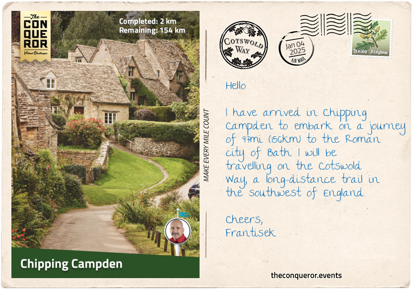
It’s a lovely, crisp sunny day in the beautifully preserved market town of Chipping Campden. I am outside the 17th-century Market Hall that was built as a shelter for market traders. Gorgeous archways surround the perimeter wall as the building takes pride of place in the centre of town. At one end is a discrete plaque marking the Cotswold Way with the words “The Beginning and the End”. Beside the sign on the ground is a circular marker stone with a brass acorn in the centre, the symbol for all UK National Trails, and a quote encircling the acorn by T.S. Eliot with the words: “Now the light falls across the open field, leaving the deep lane shuttered with branches, dark in the afternoon”. Such wonderfully inspiring words as I am about to embark on my journey.
The Cotswold Way is a long-distance walk from Chipping Campden to the Roman city of Bath. Running the length of the Cotswold escarpment, the route travels through historical villages, past stately homes, churches and battle sites. Along the way, wooded areas with ancient trees are interspersed with rolling pastures and wide-open meadows. The route can be tackled in either direction, hence the words on the plaque.
As I begin my journey, I head down High Street and take in the honey-coloured buildings lining the road. Most of them date back to the 17th century and are constructed from the oolitic limestone that is known as Cotswold stone. The oldest house in town, further up the street, is Grevel House. Built in 1380, parts of the house were remodelled and extended in the 1800s. Two gargoyles at the top of a perpendicular bay window stand guard, whilst a sundial sits in a gable above leadlight windows with coat-of-arms designs. The house used to belong to William Grevel, a wealthy wool merchant whose family has been residents of Chipping Campden for more than a century.
Less than a mile out of town, I passed by Dover’s Hill, one of Cotswold’s many great viewpoints. Near a bench is a toposcope illustrating the visible landmarks, and the views down the grassy slopes are accentuated by sheep grazing and chestnut trees hugging the perimeter. It is here that Robert Dover started the Cotswold Olimpick Games in 1622, where games such as ‘shin-kicking’ (yes, it’s true), tug-of-war, wheelbarrow relays and running races are the highlights. With the exception of a 101-year gap, it has been held every year on the first weekend of June.
Perplexed by the thought of the shin-kicking contest, I slowly toddle away from the hill and towards Broadway.
km od začátku : 0029
Winchcombe
Following the acorn waymarker, I found myself on the Mile Drive, unsurprisingly a mile-long trail section running like a canal through a mix of woodland and farmland. Carefully crossing over the A44, I entered a small section of heavily wooded area running parallel to the road. It doesn’t last long, and then I’m back in the open fields, gently ascending a hill until I reach Broadway Tower, a classic folly with expansive views from the top.
Down the hill, I went into the pretty village of Broadway. The main street is lined with red chestnut trees and Cotswold stone shops, galleries, and eateries. Broadway is closely linked to the Arts and Crafts Movement of the late 19th and early 20th centuries when artists and writers were drawn to the village’s tranquil atmosphere and away from the bustling industrial cities.
Climbing up onto the escarpment, I followed a broad track lined with trees on one side and fenced pasture on the other. At one point, the track narrowed to barely the width of my foot and was fenced on both sides. Widening once again, I arrived at Shenberrow Hill, the third-highest point on this journey.
Following a steep descent into the village of Stanton and its small population of 198, I wandered through the quiet street and back out again into the countryside. It is hailed as one of the prettiest and most unspoiled villages in the Cotswolds, and it is very pretty indeed.
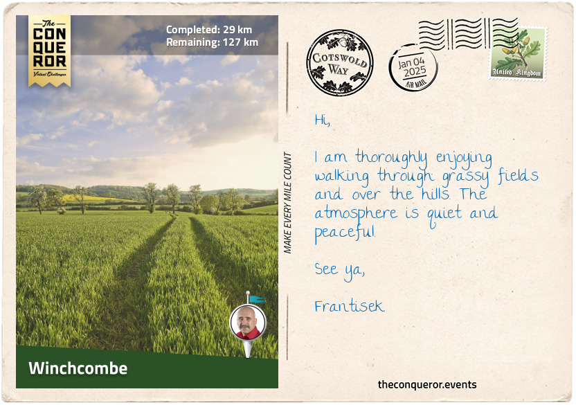
I wound my way towards Winchcombe, first on a well-paved country road and then through meadows with no obvious trail except for the marker posts guiding my way. Sections of drystone walls delineate the meadows from farmlands. These wall structures are perfectly stacked without mortar in between and yet are amazingly strong. The base is usually 2ft (60cm) wide, narrowing near the top to just 14 inches (35cm). Small stones are used to fill the gaps, and a row of upright stones complete the wall. The lack of mortar allows air to go through the stones, keeping them dry. Well-built walls can last several hundred years, as can be seen all throughout the UK.
My final stop in this section was the medieval town of Winchcombe. Dating to the Roman days, this once-walled town grew to prominence during the Anglo-Saxon period. The main street is lined with a mix of 15th-century timber-frame and limestone buildings.
Here, I’ll be looking for a place to indulge my taste buds with Double and Single Gloucester semi-hard cheese, some crackers, and a Gloucestershire cider. It is no surprise that both are closely associated with the Cotswolds, given the many manufacturers and breweries found in the region.
km od začátku : 0062
Birdlip
I left Winchcombe with a belly full of crumbly cheese and walked through the fields to Belas Knap Long Barrow. From a distance, it looked like a long hilly mound, but it was actually a Neolithic burial chamber with a false door at the front. Encircled by a drystone wall, the entrance was from the side. It’s believed to have been built around 3000 BC with four different chambers and a circle of stones in the centre. The chambers were discovered to contain the remains of human skeletons from the Bronze Age.
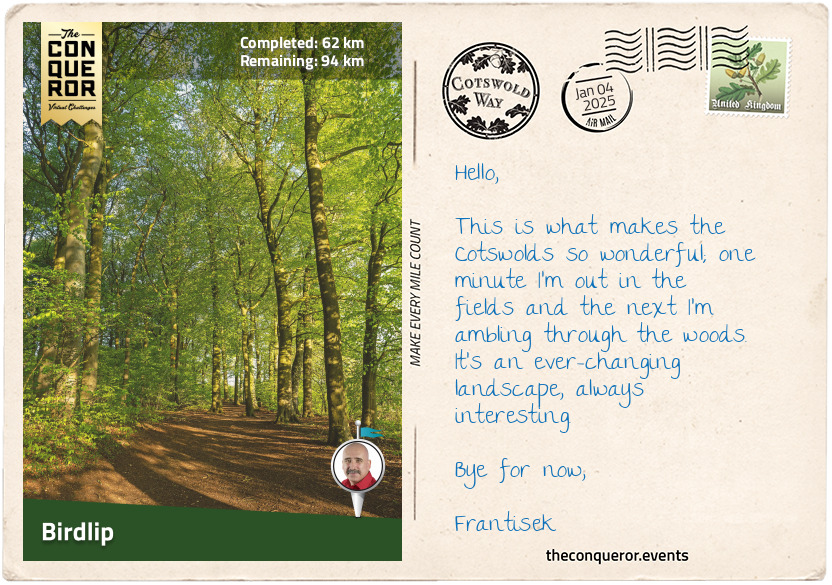
Much as I enjoy open fields and the cool breeze, I get most excited when I see woodland such as the one that I am approaching. I reached a timber gate hinged on a drystone wall with purple wildflowers to my left and a ‘common hawthorn’ tree to my right. The red berry-like fruit called ‘haws’ found on the tree are an important food source for birds, and the petals used to be a common cooking ingredient in medieval England. For the next mile, the trail narrowed as dappled sunlight filtered through the foliage of the woodland. Low-lying shrubs and grasses lined the path, with the occasional fern making an appearance.
Back in the daylight, the path led me to Cleeve Hill, with its expansive views across the countryside towards Cheltenham and Bishops Cleeve. At 1,080ft (330m), the hill is the highest point in the Cotswolds. Nearby is the ‘Single Beech’ or ‘lonely beech’, the highest tree in the Cotswolds. A memorial wall surrounds the tree, with plaques in memory of those who were fond of the area.
Passing the Prestbury Hill Butterfly Reserve, it is known for the musk orchid and the bee orchid, and the southern portion of the reserve is home to more than thirty different species of butterflies, such as the Duke of Burgundy that can only be found in England and the gorgeous Peacock with its eyespots and burnt-orange wings.
Descending to Dowdeswell Reservoir, one of few places where clawed crayfish can still be found, I continued through Lineover Wood. Known for its beech trees, this native beauty of southern England was used for furniture making, and its nuts were roasted as a tasty treat and pressed for oil to fuel lamps.
Winding my way over farmland, I passed by the hamlet of Seven Springs, where a contentious discussion continues to take place as some believe it is the true source of the River Thames. Back up the hill with more gorgeous views of Cheltenham and the Severn Vale, I follow the escarpment onto Leckhampton Hill and its distinctive limestone rock formation known as the Devil’s Chimney.
The rest of my journey on this section took me over a few more up and down hills, past the Crickley Hill Country Park with its many trails for outdoor exploration and plenty of woodlands to get lost in. I finished my trip at the local pub in Birdlip and settled on a hearty chicken, mushroom and leek pie and elderflower spritzer with a dash of grenadine.
km od začátku : 0072
Painswick
The trip from Birdlip to Painswick was reasonably short. Less than 10mi (16km), and most of it was through beautiful beech woodland.
One of my stops was Cooper’s Hill. If you recall, I mentioned the Gloucester cheese back in Winchcombe. Well, this very popular cheese makes an even bigger appearance each spring when a collection of brave or maybe a little crazy individuals engage in a 200-yard race down the extremely steep Cooper’s Hill chasing a roll of Double Gloucester cheese. As you might imagine, First Aid officers and plenty of ambulances are on standby. But the winner gets to keep the cheese.
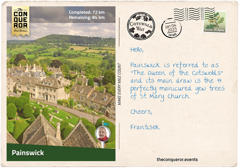
Painswick is a picturesque town that originally grew from wool trading. It is also the midpoint of the Cotswold Way. Located on a hill overlooking Painswick Valley, the town has narrow streets and typical Cotswold stone architecture. The local parish churchyard is known for its ancient and beautifully manicured yew trees. A pyramidal tomb stands out amongst the trees, and the local post office occupies a 15th-century half-timbered building.
Northeast of town is the 18th-century Rococo Garden. Originally established during the Rococo period, when palatial homes and gardens were built and decorated with flamboyance and extravagance, this grand garden was a playground for entertainment and partying. As fashions changed, so did the garden until it was abandoned in the 1950s and over the succeeding decades, it was left to overgrow. Restoration began in the late 20th century bringing it back to its original layout. A 1748 painting of the original garden was used as the basis of the restoration. Today, the garden is the only surviving Rococo Garden open to the public complete with a maze, a hidden valley and surrounded by woodland.
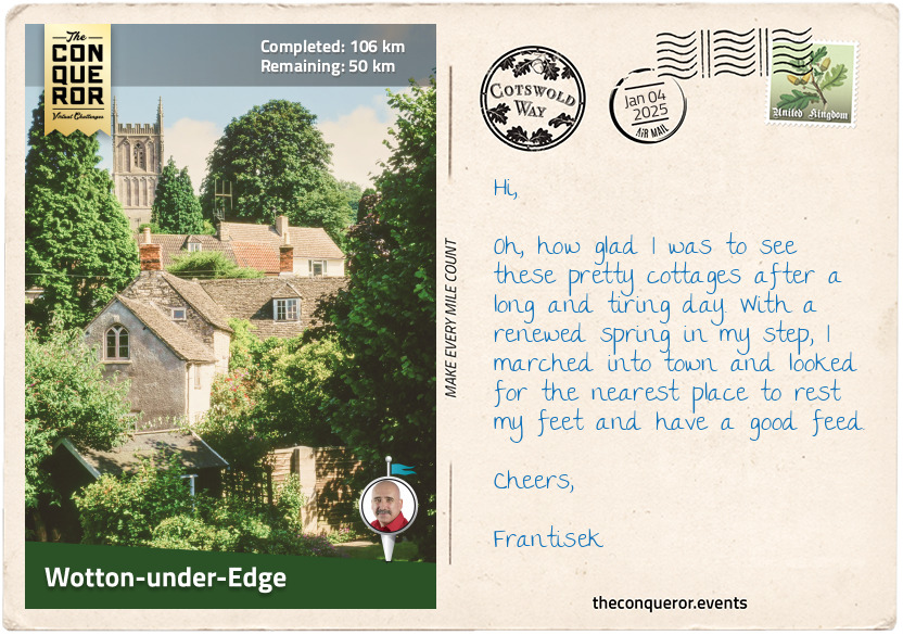
km od začátku : 0106
Wotton-under-Edge
Having left Painswick, I crossed the Wash Brook up onto the Edge Common and stopped for a gaze back over the town. Heading in and out of the woodland, I took the opportunity to slow down and admire the variety of trees and ponder their many benefits.
To that end, I aimed to work out the uses of some of the trees I was passing, starting with the Black Alder. This semi-hardwood tree can live up to 100 years. It is often used to fix soil erosion and nitrogen problems. It’s used commercially to make paper and has been used for dyeing and tanning. Because the leaves are sticky, people put them on their floors to trap fleas. It attracts woodpeckers, warblers, and wrens.
Another significant tree found in, but not limited to, the Cotswolds is the oak, an ancient timber that can live past 1,000 years. It was used to construct many of the historic properties in the region and the rest of the UK. As the national tree of England, it is woven into the fabric of the country. A great number of pubs are named ‘The Royal Oak’. It appeared on the round £1 coin from 1987-1992, and the leaves and acorn are on the National Trust’s emblem. Represented in mythology as a symbol of strength, nobility, and knowledge, this mighty English oak is home to many bird varieties. Barn owls and wood ducks like to nest in cavities formed by animals that pick too much wood from a tree.
Walking along the edge of the escarpment through Penn Wood, I emerged at Coaley Park, a popular picnic spot with an ancient burial site. The meadow is a kaleidoscope of colour during the flowering season, with purple sainfoins, mauve or white flowered clover, and delicate buttercups.
Passing a disused quarry, the trail led me through more woods, into a valley, up a nice steep climb with amazing views and then through farmland to the market town of Dursley. Climbing up steeply onto Stinchcombe Hill, I could have taken a perimeter walk around the Stinchcombe Golf Club but keeping an eye on those flying golf balls is not something I wanted to worry about; hence I carried on straight over the hill and marched on to Tyndale Monument, a tower erected in honour of William Tyndale, an early translator of the New Testament into English. I climbed the 120 steps to the top of the tower for fabulous views of the Berkeley Vale.
Continuing on, the route flattens out a little through grassland and wooded terrain to Wotton Hill. Here, an enclosure of stone and iron fence surrounds a cluster of trees planted in 1815 to commemorate the Battle of Waterloo. Following the hill down, I went straight to Wotton-Under-Edge. First mentioned in the Domesday Book of 1086 AD, the town has several notable buildings, such as the Ancient Ram Inn dating back to 1145, a public house now used for ghost tours, and the Newark Park, a Tudor hunting lodge from the mid-1500s. Newark was given to the National Trust in the mid-20th century, who, together with American architect Robert Parsons, restored the property to its former glory.
A stop at the Royal Oak Inn for a feast was a must, and there’s nothing like a Sunday Night Roast with offerings of pork belly and crackling, roast beef and stuffed chicken wrapped in bacon with side servings of Yorkshire pudding, roast potatoes and of course, a drizzle of gravy.
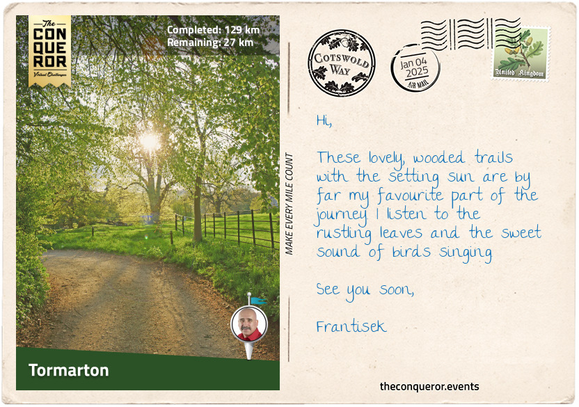
km od začátku : 0129
Tormarton
Continuing on a flat landscape, I passed the village of Wortley and diagonally crossed a pasture with grazing sheep. There are numerous breeds of sheep in the UK. However, one breed special to the area is the Cotswold Sheep. Known for their long wool, they are thought to be descendants of long-wool sheep introduced by the Romans in the first century AD. They became an important part of American farming in the early 19th century until they were replaced by Australia’s merino sheep. On the decline, the breed joined the ‘rare breed list’ until recent renewed interest by spinners. Yielding 15lb (7kg) of wool per shearing with fibres up to 20 inches (50 cm) long has turned the tide on their numbers. The fleece is described as lustrous and sometimes referred to as “poor man’s mohair”.
I entered a narrow yet densely wooded section, with little light filtering through, yet oh so delightful and exited on the outskirts of the small village of Alderley. As the trail meandered up and down the hills, I enjoyed a combination of narrow earthen paths with overarching trees providing shade and single-lane roads lined with hedges and a smattering of cottages.
About a mile before Hawkesbury, I came upon the Somerset Monument, a 100ft (30m) tall tapering stone structure with a viewing platform at the top overlooking the local area, as well as Bristol and, on a good day even as far as the Welsh border across the Severn River and Valley. Built in 1846, the tower was dedicated to Robert E. Somerset, a British soldier who fought in the Battle of Waterloo.
Hawkesbury is a small hamlet with St Mary’s Church at the centre of it. A simple church of Norman origins, it was built on the site of an earlier Saxon church whose incumbent, Wulfstan, a parish priest elevated to Bishop of Worcester, became the last surviving pre-Norman conquest bishop. A social reformer, Wolfstan was a strong opponent of the slave trade and nearly succeeded in stopping the trade between nearby Bristol and Ireland. In 2021, St Mary’s Church installed a ring of eight bells in the tower, with the largest one weighing 1,322lb (600kg) and named it in honour of Wolfstan.
Across the street from the church, up a hill, are two old walnut trees marking the location of the abandoned Hawkesbury Manor House. Owned by Charles Jenkinson, 1st Earl of Liverpool, the house is where his son Robert Jenkinson, 2nd Earl of Liverpool, was born. Robert was to become Prime Minister of the UK from 1812-1827.
A mile further from Hawkesbury, I came upon Horton Court, a National Trust property with a history stretching back to the 12th century and thought to be the oldest vicarage in England. Adjacent to the house is St James’ Church, built around 1300 from Cotswold stone.
Passing through the villages of Horton and Old Sodbury, I walked through Dodington Park, laid out in the 18th century by Lancelot ‘Capability’ Brown, a landscape architect who was prominent in the development of the English landscape garden style featuring rolling hills, lakes and groves of trees.
I ended this section of my journey in Tormarton. With my eyes set on a pot of tea with homemade scones, jam and cream, I'm off to search for a café serving it.
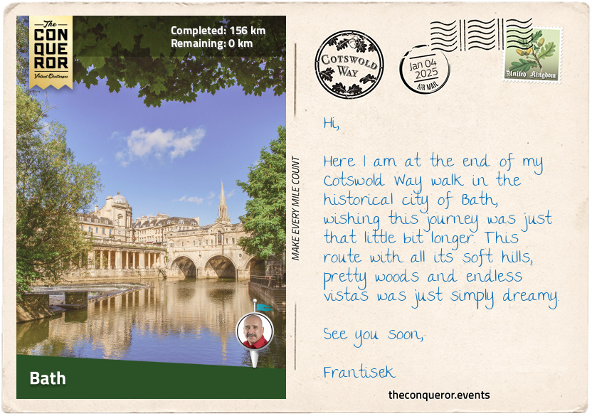
km od začátku : 0156
Bath
On the last stretch of my Cotswold Way, I walked past Dyrham Park, a lavish 17th-century house that was owned by the Blathwayt family for 230 years until its acquisition by the National Trust in the mid-20th century. It used to have a herd of fallow deer from the 1500s until 2021. Used as a film location and undergoing significant restoration works in recent years, the property is now open to the public.
The trail skirted around Lansdowne Hill, where the Battle of Lansdowne was fought during the First English Civil War (1643 AD). A fierce battle ensued between Royalists and Parliamentarians, with heavy losses for the Royalists. Over the course of that night, however, the Parliamentarians silently fled for Bath, resulting in a victory for the Royalists.
With great anticipation, I completed the rest of my journey and arrived in the gorgeous city of Bath. Entering from the northwest, I passed by a spectacular row of terraced houses in a crescent layout known as the Royal Crescent. A little further east was The Circus, a circular grassy area surrounded by curving townhouses. When viewed from the air, the two landmarks form the famous ‘question mark’ shape.
Of course, no trip to Bath is complete without a visit to the Roman Baths. Built by the Romans in the 1st century, the baths were used until their withdrawal from Britain in the 5th century. Over time the baths disappeared under silt, and the city grew on top of it. When it was rediscovered in the late 19th century, the baths were found 13ft (4m) below street level.
Adjacent to the Roman Baths is the grand Bath Abbey. Built over a century and completed in 1611, the abbey’s Gothic architecture is breathtaking. Featuring pointed arches, fan vaulting and finely carved pews, the abbey has a total of 52 windows, including the spectacular stained glass behind the altar. More than 600 wall memorials and over 800 floor stones adorn the interior dedicated to various figures throughout the city’s history.
Another fascinating landmark was Pulteney Bridge. Built in 1774, the triple-arched stone bridge is one of only four bridges in the world to have shops built across its full span. It reminds me of the Ponte-Vecchio in Florence, where the St Francis Way begins. Although Ponte-Vecchio is only open to pedestrians whilst Pulteney Bridge continues to have vehicular access.
To round up my journey, I meandered to Alexandra Park for a splendid view of the city. Here I reflected on the beautiful villages I travelled through, the rolling hills and mysterious woods and somehow wished it wasn’t over yet.