Brazil is the biggest country in South America and the 5th largest in the world (larger than both Australia and the contiguous United States). It occupies nearly 50% of the continent and it is the only Portuguese-speaking country in all of South America. Brazil is famous for its Amazon rainforest, the Amazon River (the second longest in the world after the Nile River), the Iguazu Falls, Rio Carnival, and soccer.
First known to Europeans in 1500, the territory which would be named Brazil became a Portuguese colony until 1822 when it gained its independence. Sugar production was the primary industry between 1530-1700 AD with plantations cultivated in coastal areas. Inland expansion began in the late 17th century when expeditions were carried out into the interior.
In 1693, large deposits of gold were discovered in the mountains of Minas Gerais, a south-eastern state of Brazil. New settlers flocked to the region seeking their fortune, giving rise to the gold rush era. The sugar cane industry was in decline by this stage and many people abandoned their plantations in search of gold. Gold mining became the new economic activity. A few years later diamonds were also discovered.
To facilitate the transport of gold and diamonds from the interior to the ports of Paraty and Rio de Janeiro (Rio), the Portuguese Crown built four roads that collectively became known as Estrada Real (the Royal Road). The first road ran from Ouro Preto to Paraty. The path was later superseded by a shorter and safer route from Ouro Preto to Rio de Janeiro. This route eliminated the pirate attacks that would loot the cargo on sea journeys from Paraty to Rio. The third route was northbound from Ouro Preto to the diamond exploration city of Diamantina. The last route to be created was meant to be an alternative road whilst in search of gold, except that iron ore was discovered instead.
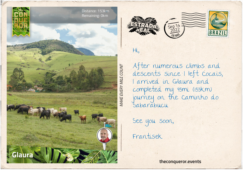
This last road, referred to as Caminho do Sabarabucu, is the route that I will be tackling on this journey. It is 95mi (153km) long, beginning in the small town of Cocais, heading west in a semi-circular motion and finishing in Glaura, a district of Ouro Preto. It is a very hilly journey with nearly half of the trip swinging between short and long climbs, both quite steep.
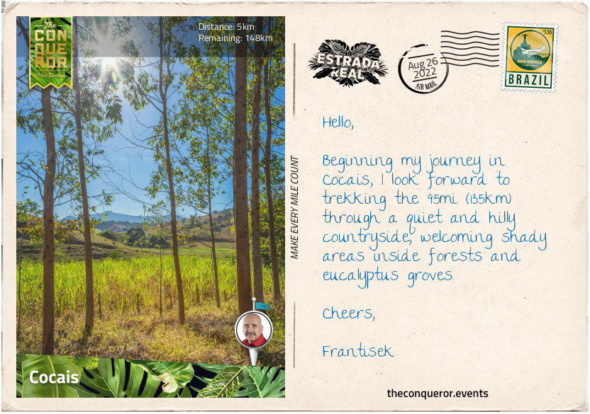
Cocais is a district of Barao de Cocais and it is the junction of the Diamantina and Sabarabucu routes. It was founded in the mid-18th century as part of the gold rush and retains many original buildings, such as the 1769 Church of Santana. Careful to take the left road at the junction, I head towards Caete.
km od začátku : 0035
Caete
The first 10mi (16km) were reasonably straight-forward. The trail was narrow, weaving in and out of forests with occasional views of the mountainous landscape and the odd villa in the distance. The road was a red dirt track barely a car-width wide. I came across a farmer riding with bags hanging off his saddle and his furry companion barking and running back and forth as they are wont to do. The shady trees provided relief from the ever-present scorching sun.
Before I knew it, I was on an upward trajectory with a long steep climb when I found myself amongst large plantations of eucalyptus trees. I hadn’t realised how significant the eucalyptus tree was in Brazil. The eucalyptus is a native tree found in most parts of Australia. It was introduced to Brazil in the early 20th century as a timber substitution and for charcoal products. Today, there are seven million hectares of eucalyptus planted in Brazil. Being a commercial success in Brazil, the country is the top exporter of eucalyptus pulp whilst local iron ore producers rely heavily on eucalyptus for charcoal.
Passing through the small village of Antonio dos Santos, I took a south-westerly approach and continued climbing up to 3608ft (1100m), gaining about 1312ft (400m) in elevation. Then I began my descent into Caete.
Although a quiet road to travel, it was easy to forget that small trucks and cars use it as well. Having to share it whilst on foot was a reminder to be aware of my surroundings.
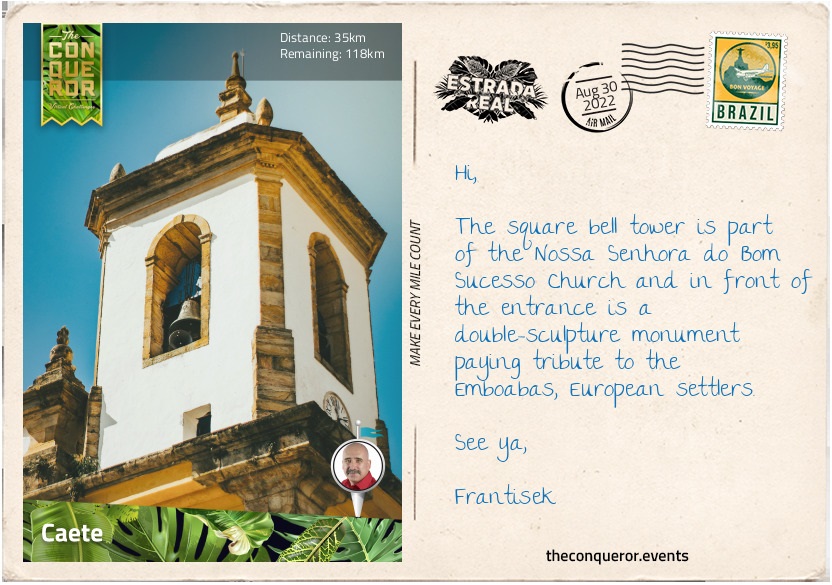
Caete was a sprawling town tucked in a valley between the mountain ranges of Serra da Piedade and the Serra do Gandarela National Park. It was named by local natives and in Tupian, an extinct native language, means “virgin forest” or “dense forest”. The town was created in 1704 and a couple of years later was at the centre of the Emboabas War, a conflict between two opposing groups of settlers over the newly discovered gold. On one side were the Bandeirantes, a group of fortune hunters and slave traders who were largely responsible for the interior expansion, claiming rights of discovery and the other were the Emboabas, the European newcomers challenging the claim. The conflict was to last four years with the Emboabas winning.
Besides the 18th and 19th century buildings, a major point of interest was the 1764 Nossa Senhora do Bom Sucesso Church that was built by Manual F Lisboa, the father of Aleijadinho, a celebrated sculptor and architect of colonial Brazil who was known for designing his works with chisels and hammers strapped to his fingerless hands.
Stopping for a meal, I ordered Frango com Quiabo which is pan-browned chicken drumsticks cooked with okra into a stew and served on a bed of rice. The dish became popular in Minas Gerais in the 19th century when transporting food from other states became difficult. Both free-range chicken and okra were easily available in the state, giving birth to the Chicken with Okra dish.
km od začátku : 0072
Sabara
Leaving Caete, I headed south with verdant landscape flanking both sides of the reddish-dirt road. After 4mi (6.4km) I walked beneath a railway line that provides service to one of two long-distance trains that remain in Brazil. This particular railway, run by a mining company, operates a passenger line that leaves Vitoria, one of the oldest Portuguese settlements (c.1551) on the Atlantic coast and travels west for 435mi (700km) to Belo Horizonte, the capital of Minas Gerais. The journey promises breath-taking views of the coast, along the Doce River, through narrow gorges with the occasional waterfall and down several steep slopes before entering a number of tunnels. As I trekked on, I saw the rail line crossing over a viaduct with the beautiful green valley spreading below.
The dirt road wound its way up the hill until it finally peaked and then I had a nice long steep descent into the village of Morro Vermelho. Single storey residential homes lined the main street with the odd one painted in powder blue or another in pale mustard with windows trimmed in blue. The descent continued past farms and banana plantations until I was back in the countryside.
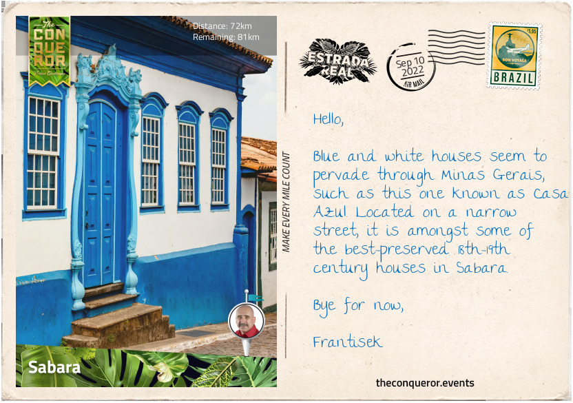
I had another short steep ascent before the final descent into Sabara. Built in 1675, it was one of the first towns to be established in Minas Gerais. Its name is an abbreviated form of tesaberabusu. In Tupian it means “great bright eyes” which refers to the gold nuggets found in the area. Originally a village that developed into a parish by the early 1700s, Sabara was elevated to a city in 1838.
Sabara’s cobblestone streets have numerous extant colonial-era buildings and many of them were along the Rua Pedro II, a heritage listed road. Several drinking fountains survived, with Kaquende, built in 1757, as one of the best known located in the old commercial centre of the city. The town had numerous churches from the 18th century. Two that stood out were Nossa Senhora do O with its Chinese influence and elaborate interior design and Nossa Senhora do Carmo that was built in a blend of baroque and rococo architecture to which architect Aleijadinho contributed to the interior decoration. The latter’s interior had beautiful, gilded carvings and detailed sculptures along with stunning fresco paintings on the ceiling. The church has heritage listing at the national level.
To finish the day, I visited the Gold Museum housed in the former Gold Foundry. During the Gold Rush, the Crown collected 20% of the extracted gold. The Foundry was used as the smelting house where the extracted gold was purified, turned into bars and had a stamp affixed to it, indicating that the required tax had been deducted. Today, the museum exhibits equipment used in mining and goldsmithing, a library detailing the history of Minas Gerais and several other items from the 18th-19th centuries.
km od začátku : 0105
Rio Acima
Heading south, most of my route from Sabara to Rio Acima was alongside the Das Velhas River. It is a major tributary of the basin of the Sao Francisco River, and is 498mi (801km) long. It is believed that the river was the original path to the discovery of gold in Minas Gerais.
The route was a combination of dirt road, trail and a small stretch of asphalt. There were considerable short ascents and descents making the trek particularly difficult and without shade.
The trail travelled through Raposos, a town established in 1690 by early settler Pedro de Morais Raposo, who arrived in the region in search of gold and precious stones. In 1910, British mining company, St John d’El Rey, opened a gold mine in Raposos. The company, operating in Brazil since 1830, employed skilled miners from Cornwall and also slaves. The company operated the mine in Raposos until the late 1950s when it was sold.
Slave labour in Brazil was extremely high during the days of the Gold Rush. By 1822 as many as 1.5 million people were enslaved. When Great Britain ramped up efforts to outlaw the slave trade, including seizing slave ships in the Atlantic Ocean, it gradually forced Brazil to follow suit and by 1888 slavery was abolished.
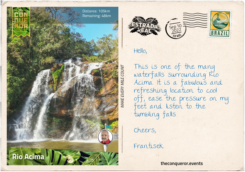
Once I descended into Honorio Bicalho, a small village on the banks of Das Velhas River, the next 10mi (16km) was reasonably flat, arriving in the relatively young town of Rio Acima. Founded in 1948, Rio Acima was surrounded by mountainous terrain, and it is said that there are nearly 60 waterfalls in the area, although most of them are on private property and therefore inaccessible.
A good resting point, I went looking for a hearty meal. Interested in Minas Gerais cuisine I wanted to try Vaca Atolada, a stew-like dish made of beef ribs cooked in a thick sauce with tomatoes, chilli peppers and cassava (a nutty-flavoured root vegetable native to South America). It was a spicy meal served on rice and because of the thick sauce, the dish’s literal translation is “bogged down cow”. Perhaps not the most appealing name for a dish but it was full of flavour and deeply satiating.
km od začátku : 0135
Acurui
Back on the dirt road, I soldiered on, continuing to climb and descend the mountain ridges, winding my way through the countryside. Most of the trail was in the open, no shade, with the sun bearing down. The occasional reprieve was welcomed when I hiked through forested sections.
It didn’t take long to arrive in Acurui. A small town, it was established in the 17th century when the region was first explored by Europeans. Today, it is a district of the nearby town of Itabirito.
The highlight of the town is its location on the banks of the Das Velhas River. The town centres around an 18th century church and a handful of shops surrounding a small square. Its economy is based on farming and a large hotel on the banks of the river.
East of Acurui was Pico do Monge (Monge Peak). On one side, the peak was a mix of verdant and rocky landscape with fabulous panoramic views and numerous waterfalls in the vicinity. The other, however, looked like layers of terraces carved into the mountain from the ridgeline all the way to the base. The side of the mountain was nearly vertical. The terraces were actually roads used by heavy machinery as part of mining operations that began in the early 1980s. A satellite view showed two incredibly different sides of the mountain. Something that would not be uncommon given the importance of mining in the state.
There are as many as 300 mining operations in Minas Gerais but there is also an abundance of waterfalls in this mountainous region. Whilst mining continues to be a significant industry, Minas Gerais is still incredibly rich in wildlife. The sky is filled with a wide array of birds including the wonderfully long-beaked toucans and the brightly coloured macaws. Whilst on the ground there are snakes like boa constrictors and pit vipers or the odd-looking giant anteater, the tapir, and the plate-armoured armadillo. Finally, there are the beautiful, yet dangerous big cats such as the puma and the jaguar. Life in the Brazilian wild persists and hopefully it will continue to maintain its rich diversity.
km od začátku : 0153
Glaura
The last 11mi (17.6km) from Acurui were more of the same, with steep ascents and descents on dirt roads all the way into Glaura, a district of Ouro Preto, where my journey ended. Glaura is where the Caminho do Sabarabucu joins with Caminho de Velho (Old Route), the route heading to Paraty.
Glaura is a small town and one of the oldest in the gold region. Founded in the 18th century, it served as a resting point for large landowners travelling from Ouro Preto or Sao Joao Del Rey. Its economy centres around fruit plantations and dairy cattle farming. It is also a producer of the dulce de leche compote, a delightful and richly flavoured sauce made of milk and sugar cooked slowly over several hours. The caramelised milk is then used to top or fill other sweet foods.
The town was built around its church, named the Church of Santo Antonio, as most towns were on this route during the colonial era. The Catholic Church is deeply enmeshed in Brazil’s culture and from 1500 to 1889 it was the official state religion. Many of the churches on this route, as can be seen by their similarities in design, were built in a baroque style, an approach during colonisation that reflected the architecture in Portugal.
If I was to hike a further 20mi (32km) southeast, I would arrive in the city of Ouro Preto where the three major Estrada Real routes intersect. However, since Caminho de Sabarabucu ends here, so shall I and with that I’ll say my farewells.