As one of the northernmost countries in continental Europe, Norway stretches along the western edge of the Scandinavian Peninsula, bordered by the North Sea to the southwest, the Norwegian Sea to the west and the Barents Sea to the northeast. This elongated country is known for its dramatic landscape of rugged mountains, thousands of islands, forests, valleys, and deep fjords carved by glaciers over millions of years.
My primary focus on this trip is journeying through Norway's fjords. I will cruise through the UNESCO-listed Geirangerfjord, cross the magnificent Sognefjord, and hike alongside the deepest lake in Europe. I'll breathe in the crisp, fresh air, rug up for the cool climate, and take every advantage of travelling during the summer season, soaking up the lengthy days when daylight lasts up to 17 hours. Although 24-hour daylight does occur further north across the Arctic Circle, I'm not travelling that far.
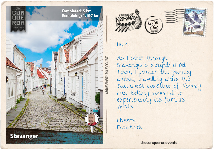
To begin my exploration, I arrived in Stavanger, one of Norway's oldest cities (circa 12th century), recognised as the Oil Capital of Norway because it is the central hub for the country's oil industry following the discovery of North Sea oil in the late 1960s.
As I pass a series of colourful buildings on Øvre Holmegate, a delightful pedestrian street lined with coffee shops and outdoor seating, I head for the picturesque Old Town, Gamle Stavanger, which features a high concentration of wooden houses. Of note is the narrow cobblestone street, Øvre Strandgate, with its row of white double-storey houses with steeply pitched roofs.
Between the colourful buildings and white houses next to Breiavatnet, a small lake in the city centre, lies the oldest church in Norway, the Cathedral of Saint Swithun, founded around 1125. Built from stone, the cathedral combines Romanesque and Gothic architectural styles. Its interior seems unusually narrow for a church but features grand vaulted ceilings, stone-arched stained-glass windows, and whitewashed walls.
Before I continue with my journey, I will take a moment to enjoy a Norwegian dish and decide on "kompe". This dumpling dish is made of grated potatoes mixed with flour to hold its shape, then rolled into balls and cooked in boiling water. Although plain in flavour, it is a hearty meal drizzled with melted butter and a sprinkling of salt, served with sausages and mashed vegetables of swede and carrots.
As I savour this traditional dish, I pause momentarily to appreciate the humble potato. Introduced to Norway in the mid-18th century, it became a crucial staple in Norwegian diets by the 19th century. It offered a reliable source of nutrition, food security and agricultural diversity. Interestingly, this simple crop is celebrated globally with a United Nations-designated International Day of Potato every year on 30 May.
km od začátku : 0080
Haugesund
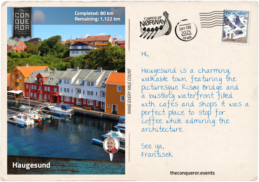
At 28mi² (73km²) in terms of area, Haugesund isn't particularly big for a Norwegian municipality, but it packs in many interesting sites and has a rich history, beginning with Avaldsnes. Located about 5mi (8km) south of Haugesund, Avaldsnes was the first royal seat of Norway. Established by King Harald Fairhair, he was the first king to unify Norway by merging several small kingdoms into one, ruling for nearly 60 years from 872 to 930.
A statue of the king with long billowing hair and shield in hand was erected up on a hill in Haraldsgata (Harald's Street), a quiet residential neighbourhood in Haugesund. Legend says that Harald vowed not to cut or comb his hair until he became the sole ruler of a unified Norway. One story refers to him as Harald Lufa (Harald Matted-Hair), but once he succeeded as the King of Norway, his hair was combed out, showing its lushness, and subsequently renamed Harald Fairhair.
Harald's statue overlooks the Karmsund Strait, highlighting Haugesund's historical significance. The Karmsund Strait was a safe and vital route along the Norwegian coast, making Haugesund an important maritime hub during the Viking Age. This route, known as Nordvegen or "The North Way", is a key part of the region's Viking heritage and is believed to be the origin of the name "Norway".
Continuing with Viking history, I checked out the Haraldshaugen National Monument, which is believed to be the burial site of Harald. Discovered last century, the burial mound was marked with a monument in 1872 to celebrate 1000 years since unification. The mound is topped with a granite obelisk containing four bronze panels depicting key moments in Harald's life and surrounded by 29 standing stones representing the old Norwegian counties.
Heading further north of Haugesund to Kvalsvik Cove, I was intrigued by Jason deCaires Taylor's "The Rising Tide" artworks. Originally installed in London's Thames River, this piece features four horse-shaped sculptures with oil pumpjack heads, symbolising the impact of fossil fuels. In 2019, they were relocated to Kvalsvik Sculpture Park, where they are partially submerged in the cove's waters.
A notable and somewhat surprising feature in Haugesund is the statue of Marilyn Monroe. Unveiled in 1992, it celebrated a familial connection to the area. While that connection has since been reassessed, the statue remains a charming tribute to an iconic figure and a nod to a golden age of Hollywood. It was an unexpected and enjoyable sight that added a touch of glamour to Haugesund.
km od začátku : 0161
Birds
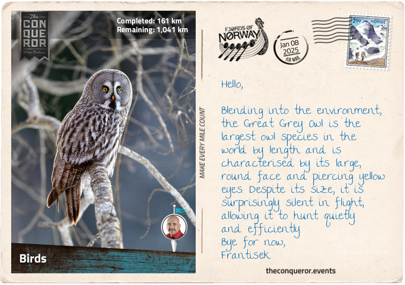
Norway's varied landscape of mountains, fjords, coasts, tundras, and alpine zones is home to a rich and diverse bird population of more than 300 species. It is an important breeding ground for migratory birds that come from as far away as Asia and Africa. Its unique geography provides ideal conditions for a range of birds. For instance, the mountains and tundra regions are ideal for Rock Ptarmigans, which are adapted to the cold environment, while the wetlands are suited to species such as the Slavonian Grebe, which breeds in freshwater habitats. During the breeding season, the Slavonian Grebe has a striking appearance with a bright chestnut-red neck and head with long black feather-like plumes on its head, large yellow tufts behind red eyes and a pointy, slender bill with a slight hook at the tip.
Around the coastal areas, the much-loved puffin wins the prize. With their bright orange triangular beaks, black and white plumage and webbed feet, these compact, barrel-shaped seabirds are native to the Atlantic Ocean, particularly the North Atlantic, nesting on coastal cliffs and islands. However, through the fjords, one must keep an eye on the sky for the largest bird of prey in Europe, the white-tailed eagle. This brown-feathered, white-tailed raptor with a large, hooked beak has an impressive wingspan of 8ft (2.5m) that can't be missed when it soars high in the sky to spot prey and then dives to catch it with its strong, sharp talons.
Adapted to Norway's coniferous forests, the Red Crossbill is a unique finch with a distinctive bill that crosses at the tips. This special bill helps the bird expertly extract seeds from conifer cones like spruce and pine. Red Crossbills are nomadic, following the availability of cones. They often travel in large flocks and are frequently heard before seen, thanks to their distinctive "chip-chip" calls. Males sport vibrant red and orange feathers, while females are more subtle, with yellow-green tones.
Norway's birdlife holds significant cultural value and is a prominent feature in Norwegian folklore. In Norse mythology, the god Odin is accompanied by two ravens representing thought and memory. Odin also transforms into an eagle to steal a magical drink that grants wisdom and poetic skills. The eagle, symbolising freedom and strength, highlights Odin's courage and determination as he evades a giant in his quest for knowledge and artistic ability.
The White-throated Dipper is Norway's national bird. Adapted to life in fast-flowing rivers and waterfalls, it builds its nest behind cascading water. Able to dive and swim short distances underwater, the dipper embodies Norway's rugged natural beauty and resilience.
km od začátku : 0209
Hardangerfjord
Getting around Norway's rugged coastline is quite an adventure. It requires different modes of transportation to make my way north. Take, for instance, crossing Bømlafjord. The most efficient way was to drive through the Bømlafjord Tunnel 854ft (260m) under the sea. The tunnel is nearly 5mi (8km) long, starting north of Valestrand and ending in Føyno.
From Heiane, I hopped on the Skjersholmane-Ranavik ferry and traversed the fjord diagonally to Halsnøy Abbey. Skirting around the fjord to Løfallstrand for another ferry crossing, I made a brief stop to check out a tall tower where the Norsafe Academy Årsnes conducts offshore lifeboat drop tests, with free falls from the tower.
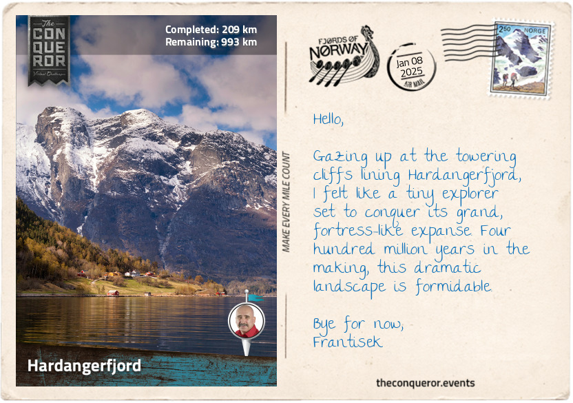
Once on the ferry again, I admired the vastness of Hardangerfjord and contemplated the origin of the word "fjord". In Proto-Germanic, the common ancestor of all Germanic languages, including the Scandinavian ones, the word "fjord" is derived from "ferþuz", meaning a body of water used for passage or travel. This evolved into "fjǫrðr" in Old Norse, referring to a narrow sea inlet bordered by steep cliffs or mountains. In modern Norwegian, it became "fjord", a term that was eventually adopted into English.
As I continued to marvel at Hardangerfjord, I was struck by its sheer scale. Hardangerfjord is Norway's second longest fjord, stretching 111mi (179km) from the Atlantic Ocean into its mountainous interior. At its deepest point, the fjord plunges to 2,922ft (890m). Featuring several major branches, the longest arm is Sørfjorden, extending 24mi (38km) south toward Odda, the largest town in the area. Branching north is Eidfjorden, and spanning the fjord is the Hardanger Bridge, Norway's longest suspension bridge at 4,530ft (1,380m) and the world's longest tunnel-to-tunnel suspension bridge.
Having successfully disembarked the ferry in Gjerdmundshamn, my next stop will be Bergen after crossing another fjord, the Bjørnafjorden.
km od začátku : 0290
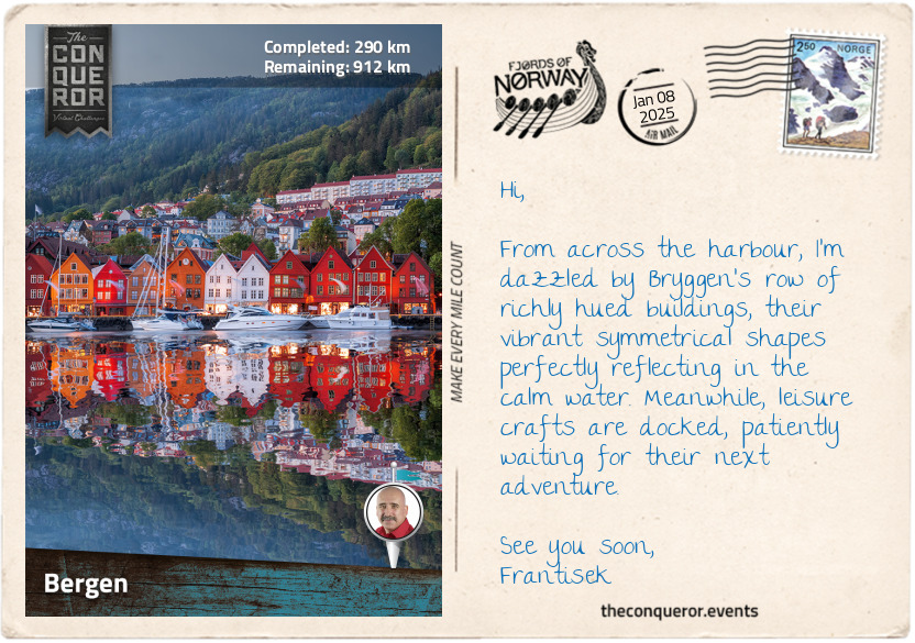
Bergen
Surrounded by many mountains, Bergen is affectionately known as "the city between seven mountains". The idea comes from Ludvig Holberg, a 17th-century playwright who admired the Seven Hills of Rome and wished his hometown had its own set of seven. With so many mountains around Bergen, it's unclear which exact seven are meant. The number seven is often seen as lucky and has a lot of symbolic meaning in different cultures, so the concept of the seven mountains is more about tradition and legend than exact geography.
Bergen was founded around 1070 by King Olav Kyrre (Olaf the Peaceful) and was originally named Bjørgvin. It served as Norway's capital in the 13th century and was the largest city until the 1830s when Oslo (the current capital) took over. The city is a major centre for aquaculture, shipping, and subsea technology. It is one of the busiest ports for freight and passengers, with as many as 300 cruise ships calling each year.
Bergen is a major centre for education, hosting several important institutions. The Norwegian School of Economics, established in 1936, was the first business school in Norway. The University of Bergen, founded in 1946, is a well-known public research university. The Bergen School of Meteorology started in 1917 as a pioneering institution studying weather and climate. It played a key role in understanding weather patterns and influenced how weather forecasting is conducted and how responses to forecasts are managed.
In the heart of Bergen, along the eastern side of Vågen harbour, lies Bryggen, the city's most famous landmark and a World Heritage Site. This historic waterfront is known for its iconic row of colourful wooden buildings. Dating back to the Middle Ages, Bryggen was a key trading hub for the Hanseatic League, a group of merchants and market towns in Northern Europe. The buildings served as offices, warehouses, and homes. While fires destroyed the original structures, the current buildings, dating back to 1702, were reconstructed in the traditional style to preserve the area's historic character.
While I enjoyed meandering through Bergen's historic and charming streets, no billboards in site because they are not permitted, I longed for the opportunity to see the skyline from above. Catching the Fløibanen funicular from the city centre to Mount Fløyen, I was rewarded with stunning panoramic views of Bergen, the harbour and the North Sea.
km od začátku : 0354
Fårikål
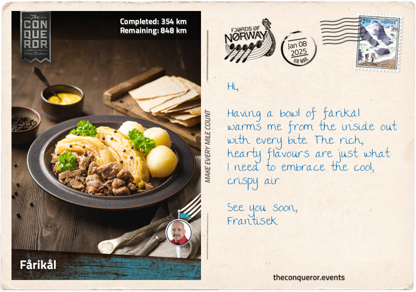
An unofficial national dish since the 1970s, fårikål is a hearty mutton and cabbage stew. Typically served with boiled potatoes, it is slow-cooked over several hours until the mutton is soft and tender. Fårikål is an old dish dating back several centuries. The concept of cooking meat and cabbage together can be traced to 18th-century German cookbooks before spreading to Denmark and finding its way into Norwegian cuisine by the 19th century. By the early 20th century, fårikål had become a staple in Norwegian diets. In 2014, a survey was conducted to discover what the Norwegians considered the national dish. With a landslide win, fårikål took the number one spot and was officially announced as Norway's national dish.
Fårikål is deeply rooted in autumn traditions. As autumn arrives in September, it's the perfect time to make fårikål because it coincides with the mutton harvesting season in Norway and the fresh cabbage harvest. The dish's heartiness makes it particularly comforting as the weather cools. It's a traditional way to celebrate the harvest and embrace the changing season.
Preparing the stew is quite simple, as it only requires four ingredients: mutton, cabbage, salt, and peppercorns. You just need time to let it simmer, making it perfect for when you're busy with other tasks at home. Even better is leaving the finished stew overnight, as the flavours have more time to infuse and develop. This dish is wonderfully suited for a gathering with family and friends. Give this recipe a try.
FÅRIKÅL (Serves 4)
Ingredients:
2 cabbages
4.4lbs (2kg) of lamb meat cut in large chunks (neck, shoulder, shank)
5 teaspoons of black peppercorn
3 teaspoons of salt
2 cups of water
4 large potatoes, boiled with skin on
Method:
1. Remove the outer layer of the cabbages, rinse and quarter, leaving the stem in place. Then, cut into wedges. Refrain from cutting the wedge in half; you want to keep the wedge's shape.
In a large saucepan, layer meat first, then cabbage, a teaspoon of salt and peppercorn. Keep layering until you finish with the cabbage on top.
2. Add the water, bring it to a boil and then turn it down to simmer until the meat is tender and pulls apart. Approximately 2 hours.
3. Check for flavour, and adjust accordingly.
4. Transfer to a serving plate and serve with boiled potato.
Notes:
1. To thicken the stew, mix the lamb in some flour before adding it to the pot.
2. As the cabbage releases water, adding more as needed rather than too much at the start is best, as too much will dilute the flavour.
km od začátku : 0422
Sognefjord
Continuing north along the coastline, passing fjord after fjord, I'm struck by the sheer magnitude of it all. Grand mountains, seemingly touching the sky, and rolling verdant landscapes border the deep turquoise fjords. It's incredible to think that more than 1,000 fjords are part of this coastline, which weaves in and out for over 62,000 miles (100,000 km). Along with nearly 240,000 islands (of which only 60 are inhabited), this staggering number gives Norway the second-longest coastline in the world after Canada.
Taking in the mountainous terrain, I observe how they rise in different forms—some casting long shadows, others crowned with snowy peaks. I can vividly imagine how these fjords came to be. Glaciers once dominated this land, carving deep valleys as they moved. As they retreated, these valleys filled with seawater, giving rise to the stunning fjords stretching before me. Ancient natural history is etched in every curve and contour of this landscape, illustrating nature's powerful force.
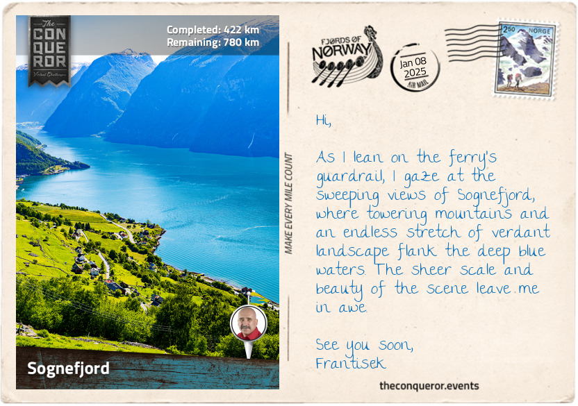
Approaching Sognefjord, Norway's longest and deepest fjord, I prepare for a ferry crossing that will take me further into this breathtaking region. Stretching inland 127mi (204km) with depths of 4,291ft (1,308m), Sognefjord is unsurprisingly nicknamed the "King of the Fjords".
Boarding the ferry at Rutledal, I begin the journey across Sognefjord's expansive mouth. I marvel at its vastness as I cross its deepest section, where depths of over 3,300ft (1,000m) extend for the next 62mi (100km). Like most major fjords, Sognefjord has several branches, including Sognesjøen at its mouth, which is also its longest at 22mi (35km). Other notable branches are Nærøyfjord, a UNESCO site, and Aurlandsfjord, known for its narrow passage, just 1.2mi (2km) wide.
There are many ferry crossings on the Sognefjord. One that stands out is the MV Ampere, the world's first battery-electric car ferry. It runs between Lavik and Ytre Oppedal, a bit further inland from my current position. It represents a big step forward in sustainable travel. Since it launched in 2015, the MV Ampere has been powered entirely by electricity, making it a much cleaner and quieter way to cross the fjord. Its positive impact on the environment has set the stage for more electric ferries to be introduced across Norway.
km od začátku : 0547
Sunnfjord
From Leirvik to Vadheim, I travelled along the northern banks of Sognefjord, then turned inland, continuing alongside the Ytredalselva River. Its waters carved through the valley, flanked by steep, forested slopes. The river's presence added charm to the journey, especially at Gamle Ytredal Bru. This ancient stone bridge blends seamlessly into the landscape. The picnic table in the adjacent rest area offered a chance to pause and appreciate the deep green slopes, the gently meandering river, and the bridge's harmonious integration into the scenery.
Next, I passed two lakes that seemed to connect before I entered the Okslands Tunnel for the next 2,600ft (800m). Emerging from the tunnel, the lake's scenic view reappeared, accompanying me briefly.
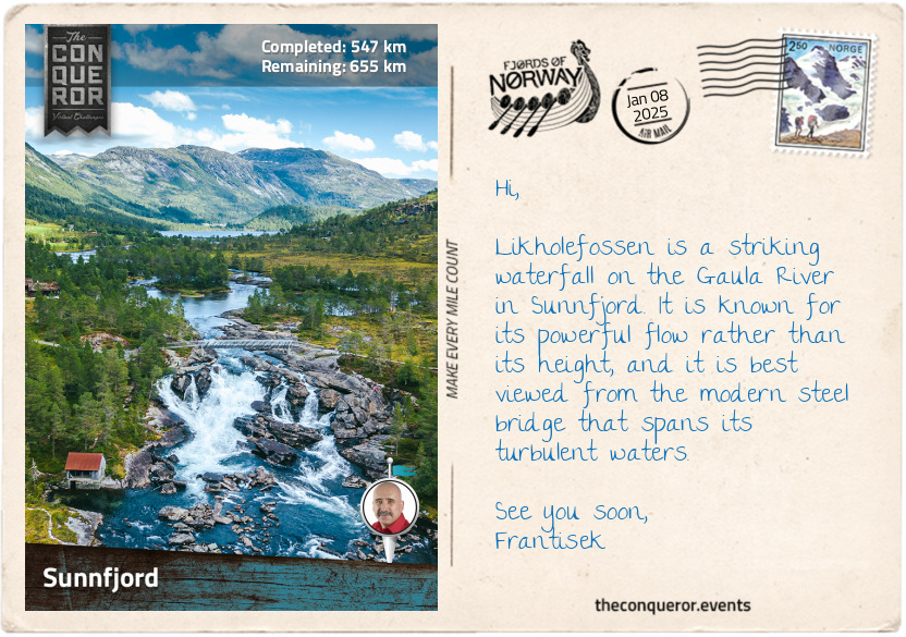
Near Sande, I crossed a particularly turbulent section of the Gaula River, where the waters cascaded into a short but dramatic waterfall before eventually calming. The Gaula is a prominent river in the Sunnfjord, a district whose name means 'Southern Fjord'. Originating from glacial runoff in the Gaularfjellet mountains further inland, the river drops over 2,300ft (700m) in elevation, contributing to its many waterfalls. The 39mi (63km) river ultimately flows into Dalsfjorden at Osen, near Bygstad. Dalsfjorden is a very narrow fjord, measuring just 0.31mi (500m) in some areas.
Approaching Førde, I entered a bustling town where the Jølstra River cuts through the heart of the community. The river flows from the nearby lake Jølstravatnet to Førdefjorden, the secondary major fjord in the region after Dalsfjorden. Rich in salmon and sea trout, the river is open for fishing for two months each year. Førdefjorden extends 22mi (35km) inland from the coast, forming a prominent feature of the town's landscape. Strategically located at the base of the fjord, Førde serves as a key commercial and administrative hub, with its role as a centre for industry, government, and university programs.
Leaving Førde, I followed the road along Førdefjorden until I reached the charming village of Naustdal. Nestled by the fjord and surrounded by mountains, Naustdal is a peaceful and quiet spot. The village is dotted on the green hillsides along the banks of the Nausta River, making it easy to see why agriculture, fishing, and forestry are its main industries. Enjoying its serenity, it feels like the perfect place to stop and rejuvenate.
km od začátku : 0620
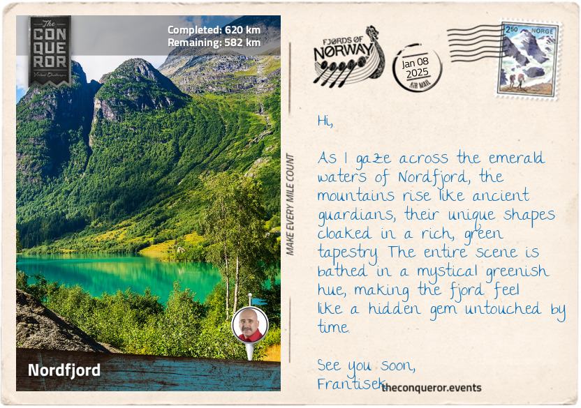
Nordfjord
As I exit Sunnfjord and enter Nordfjord, I move into the 'Northern Fjord' region, which serves as both a district and a fjord. Nordfjord is Norway's sixth-longest fjord, although that depends on who's measuring the other fjords because it has also been listed as the fifth-longest. Measuring 66mi (106km), it stretches from the coastal town of Måløy to the village of Loen, deep into the country's interior. The landscape never ceases to amaze me, with its steep, dramatic mountains rising from the fjord's edges. Mainland Europe's largest glacier, Jostedalsbreen, is also in this region.
There are two ways to experience terrific aerial views in Loen. First, the easy and relaxed version via the Loen Skylift, a cable car ride from the fjord base to the mountain summit. It has a gradient of up to 60 degrees, making it one of the steepest aerial tramways in the world. While it only takes a few minutes to reach the top, it is absolutely worth the journey for views of the fjord, lakes, mountains, and glaciers. Operating year-round, I imagine the wintry scenery would be just as breathtaking.
For a more adventurous experience, there's the Via Ferrata, meaning "iron path" in Italian. This climbing route, equipped with steel cables, ladders, and anchors, takes climbers up the rugged terrain of Hoven Mountain. The highlight is crossing the 394ft (120m) long, narrow suspension bridge, Gjølmunnebrua, with stunning views of the fjord some 2,625ft (800m) below. This journey is not for the faint of heart or anyone sensitive to heights.
For those seeking even more thrill, the recently opened zipline hurtles you across the Tungejølet gorge, 3,280ft (1,000m) above the fjord. Alternatively, the Loen Skylift offers launching sites for base jumping or paragliding for a total adrenaline rush.
Norway's cool climate is ideal for growing lingonberries and cloudberries. Small and red, the lingonberries are often made into jam and served with meat, such as meatballs. Cloudberries, or multer in Norwegian, have a brief growing season and can be hard to find. These amber-coloured fruits, similar to blackberries, are delicious when made into traditional cloudberry cream—a blend of berries and sugar gently folded into whipped cream. This delightful cream can be enjoyed on its own or served inside a krumkake, a Norwegian waffle cookie resembling an ice cream cone. Craving a sweet treat now, I hope to find some on my travels.
km od začátku : 0642
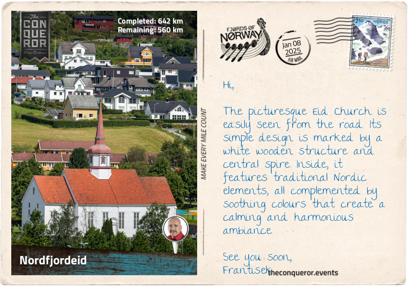
Nordfjordeid
Crossing Eidsfjord, an arm of the larger Nordfjord, by ferry to its northern banks, my next destination was Nordfjordeid. Located at the fjord's eastern end, the town is a commercial hub for the Nordfjord region.
The town has a long history dating back to the Viking Age when it was referred to as Eygis, meaning the innermost part of a fjord. At the time, Nordfjordeid was the home of Audbjörn Frøybjørnsson, ruler of the kingdom of Firda (Firðafylkí). As ruler of a petty kingdom, Audbjörn was reluctant to be part of Norway's unification led by Harald Fairhair. In 870, he was killed in a battle against Harald and buried in a gravemound on his farm.
In 1874, an archaeologist excavated the mound and discovered a male skeleton, believed to be that of the king, along with the burned remains of the largest Viking ship ever found—the Myklebust Ship. Nearby, the Sagastad Viking Center displays a full-scale replica of this ship. Measuring 98ft (30m) in length, the replica is fully seaworthy. Every April, with the help of many volunteers, it is launched into the fjord for a sea journey with a rowing crew of nearly 50 people, echoing the days when Viking seafarers navigated the waters in their longships.
Another highlight in town is the Fjord Horse statue, a tribute to a special breed of horses that's been part of the region for thousands of years. Nordfjordeid is often called the 'Mecca of the Fjord Horse', and it's easy to see why. Stallion shows have been held here since 1886, and the town is home to the Norwegian Fjord Horse Centre. This place is a hub for preserving and promoting the breed, which is especially important as it's become endangered due to the low number of foals born each year.
The Fjord horse is a small but sturdy breed, one of the oldest and purest in Norway. It was used by the Vikings as a war mount and later on farms. Its strength and durability make it special, especially in mountainous terrain. Despite its tough build, it is light, agile, and has a calm temperament, making it perfect for heavy work and riding.
Leaving Nordfjordeid, I travelled through the valley, following the Eidselva River to Mogrenda, a village on the western shore of Hornindalsvatnet, Europe's deepest lake. At 1,686ft (514m), Hornindalsvatnet's depth extends nearly 90% below sea level, highlighting how deep glacial lakes can carve out the landscape. This is unique since most lakes maintain their depth well above sea level, especially in elevated areas like mountain ranges.
km od začátku : 0719
Seven Sisters Waterfall
Once I reached the end of Hornindalsvatnet, I had a fairly short journey through another valley to Hellesylt, where I boarded a ferry to Geiranger. The journey through the valley was straightforward. Although the road wasn't very winding, it was certainly narrow for two-way traffic—a common sight in mountainous areas. Brooks and creeks intersected the road, flowing beneath it to join the Horndøla River, which runs parallel to the main road before changing direction to pass under the old Horndøla footbridge. This 164ft (50m) long bridge, made of dry stone slabs using a cantilever technique, is nearly a century old and part of the Trondheim Post Road. This key postal and transport route, established in the 18th century, was an engineering achievement, extending more than 435mi (700km) across mountainous terrain and challenging waterways, navigable by horse, rowboat, or on foot.
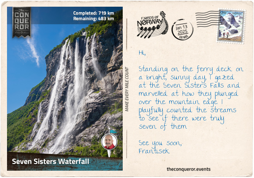
Hellesylt is a small village located at the head of Sunnylvsfjord, and it is the gateway to Geirangerfjord, one of its branches. At 9.5mi (15km), Geirangerfjord may not be particularly long, but its striking beauty has earned it a UNESCO designation. The fjord's narrowness, less than a mile (1.5km) wide, is matched by the proximity of the mountains as they rise from the water. The highlights along the fjord are the many waterfalls cascading down from the mountain tops, with Seven Sisters Falls being the most prominent. The Seven Sisters have a drop of 1,350ft (410m) and are made up of seven streams, hence the name. Directly opposite is Friaren, meaning Suitor, a gushing stream that splits in two. Legend says that the Suitor is always playfully dancing with the Seven Sisters, trying to propose but never succeeding. As the ferry proceeds eastward, Bringefossen is at the fjord's bend, fed by the melted snow from the Gomsdalen Valley above. A little further on the same side is Gjerdefossen, the only waterfall in the fjord visible from Geiranger.
The ferry ride itself was spectacular, offering stunning views of the fjord, but I imagine that a journey through the fjords on a cruise ship would be an even more immersive experience, allowing for a deeper appreciation of their grandeur and beauty.
km od začátku : 0727
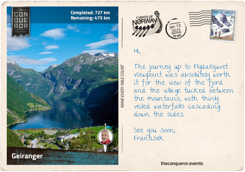
Geiranger
I looked forward to disembarking in Geiranger. This small village of 250 people swells significantly during the cruising season, with up to 300,000 passengers visiting. To accommodate this influx, a clever floating pier was installed around ten years ago, capable of servicing up to 4,000 tourists every hour. In short, summer here is incredibly busy.
Being early in the day, I decided to spend a few hours hiking up to Storsæterfossen, one of the region's more iconic waterfalls. I grabbed an e-bike from town and rode up to Vesterås Restaurant to save my legs for the trail. After a hot cuppa, I began my hike by passing through a gate. As I ascended gradually, I followed a stone pathway with hundreds of steps, apparently laid by Nepalese sherpas. The views were as gorgeous as anticipated, and now and then, my path was shared with local sheep, nestled on the stones, unperturbed by my presence.
As I kept ascending, the roar of Storsæterfossen grew louder with every step, confirming I was heading in the right direction. Soon, I caught a glimpse of its powerful plunge amidst the lush landscape and jagged rocky peak beyond.
Reaching the grassy plateau above the falls, I turned right and carefully descended a narrow path, partially protected by chain guardrails on one side and the rock face on the other. This path led directly beneath the falls. It was slick, requiring me to crouch under overhanging rocks while the chain barriers kept me safe from the steep drop-offs. Standing behind the waterfall, I felt the mist on my face as the water thundered into the valley below, the deafening sound echoing all around me.
On the way back, I was delighted to discover wild blueberries growing along the trail. Eating them straight off the bush was a real treat! These berries, smaller and deeper purple than store-bought ones, cover the forest floor during summer. They taste more tart than I'm used to, but I could imagine them sprinkled with sugar or baked into pies. Even better, these blueberries are packed with antioxidants, making them a great way to refuel.
Hopping back on my e-bike, I pedalled to the Norwegian Fjord Centre, where displays explained the fjord's formation and how plants and animals adapted to the environment. Nearby, a walkway led to a viewing platform by the Geirangerelva, where the river tumbled toward the fjord, creating the Kleivafossen and Storfossen waterfalls. As I continued descending, the views of the village and the fjord beyond were a visual feast. Though small, Geiranger packs in a lot of stunning landscapes, so it's no surprise the fjord is now a UNESCO site.
km od začátku : 0830
Ålesund
As much as I adored Geiranger, it was time to leave and tackle the winding journey up to the Ørnesvingen Viewpoint. The road, known as Ørnevegen, took me through eleven sharp hairpin bends that carved their way up the steep, lush hillside from Geiranger towards Eidsdal. After navigating the final bend, I reached the Ørnesvingen Viewpoint, where I took a well-deserved break to soak in the stunning view of Geirangerfjord.
From Eidsdal further north, I crossed Storfjord several times as I navigated toward Ålesund. Storfjord is the fifth-longest Norwegian fjord at 68mi (110km) in length, but that depends on what portions of the fjord are included in the calculation. Other scholars indicate it is only 53mi (86km), placing it sixth behind Nordfjord. Beginning near Flisneset, the fjord runs eastward before branching off into two arms, Norddalsfjord near Eidsdal and Sunnylvsfjord running south to Hellesylt before branching again with Geirangerfjord as its innermost arm. Steep, rugged mountains with alpine characteristics surround the fjord, occasionally interrupted by gentle valleys.
At Sykkylven, I crossed Storfjord once again onto Oksenøya Island, passing Brusdalsvatnet. This vast lake serves as a drinking water reservoir. I imagined that with the purity of the waterways in these Scandinavian regions, the lake's water must be exceptionally clean and refreshing.
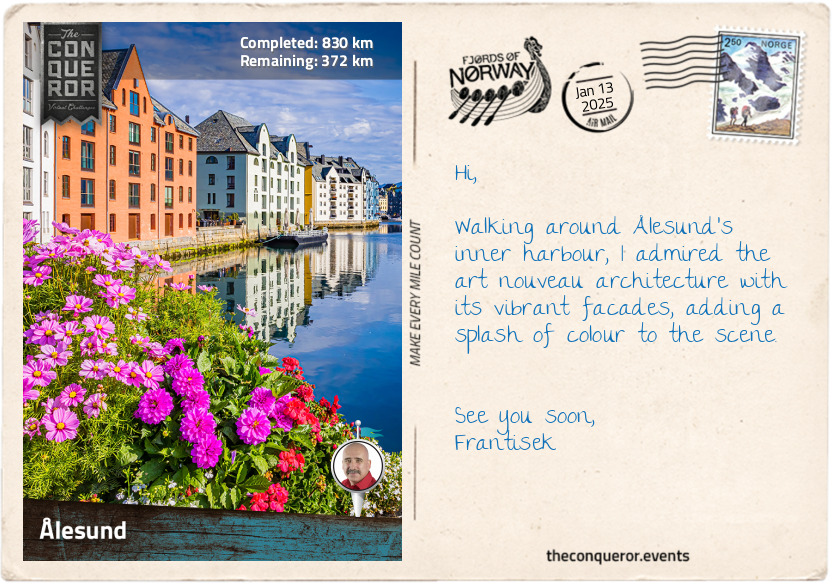
Rolling into Ålesund, I was struck by its charming art nouveau architecture. The town's distinctive look comes from a fire in January 1904 that destroyed much of the old wooden buildings. When it was rebuilt, the new structures were made of stone and brick in the art nouveau style. The inner harbour stands out with its colourful, 4-5 storey buildings, each with a similar design.
Looking for an aerial view, I climbed the long series of steps – all 418 of them - up to Mount Aksla. Famished, I found the restaurant at the top was the perfect location for lunch and a view. I settled on salmon with scrambled eggs.
At the base of the steps is the Town Park, featuring a statue of Rollo the Viking, known as Gange-Rolf in Norway. Rollo, believed to have originated from the island of Giske near Ålesund, was a formidable Viking who served under Harald Fairhair. In search of new opportunities, he led raids in northern France and, in 911, struck a deal with the Frankish king, Charles the Simple. This treaty gave Rollo land in exchange for his loyalty and protection against other Viking raids. Adopting the name Robert, Rollo ruled over Normandy as a duke, establishing a legacy with far-reaching impacts. His great-great-grandson, William the Conqueror, would go on to shape the history of England after his successful invasion in 1066, making Rollo an ancestor of the English royal family and linking the Viking warrior to some of the most significant events of European history.
km od začátku : 0917
Molde
Leaving Ålesund behind, I set out to explore Molde, the "Town of Roses". The journey to the ferry terminal was scenic, winding through stunning valleys, charming towns, past sparkling fjords and forested slopes. At Vestnes, I boarded the ferry for the 6.8mi (11km) crossing of Romsdalsfjord. The fjord is a threshold fjord, featuring a shallow underwater ridge at its entrance that separates it from the open sea. This ridge affects water flow, creating unique conditions within the fjord, such as less salinity and distinct water layers compared to the surrounding ocean. As a result, the fjord supports different marine life, including flatfish, sea stars, moon jellyfish, and blue mussels, which prefer the less salty water. In contrast, the open ocean is home to species like mackerel, cod, dolphins, whales, and oceanic plankton.
Stepping off the ferry, I first noticed the garden beds and big flower pots overflowing with roses lining the streets in town. It's easy to see why Molde is nicknamed the "Town of Roses". The tradition of growing roses in public spaces and private gardens dates back to the late 20th century when Molde was a popular tourist destination. This tradition continues, giving Molde a splash of colour with stunning roses blooming all summer.
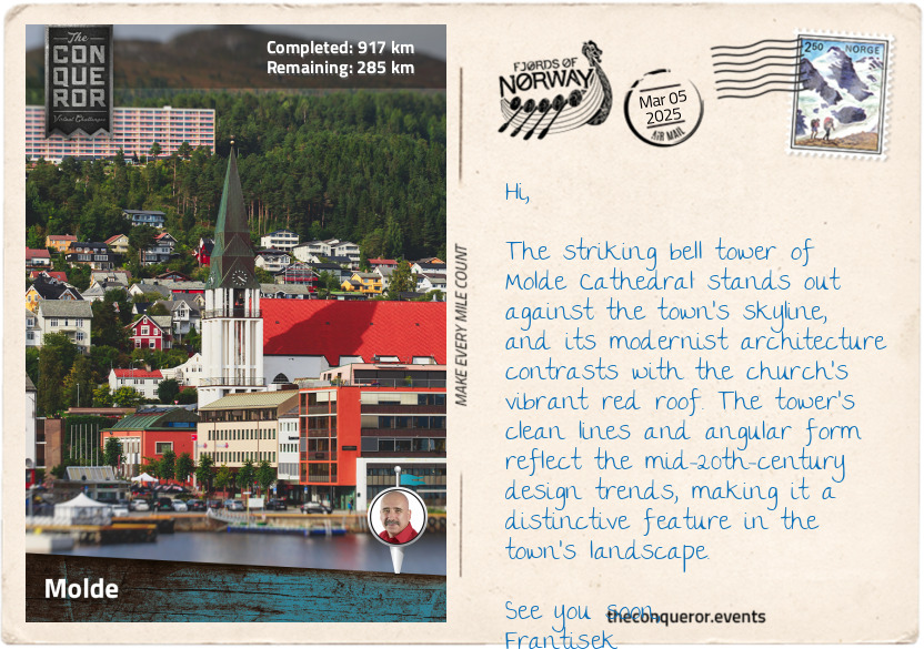
One of the most striking architectural features in town is the standalone bell tower of the Molde Cathedral. Erected in 1957, the cathedral has a modernist design with sharp, angular lines, but it's the towering spire that captures the viewer's eye, visible from a great distance.
Each July, the town brims with musicians when Molde hosts the International Jazz Festival. Established in 1961, the festival is one of the largest and oldest in Europe, attracting nearly 100,000 visitors during its week-long run. During this time, the air is filled with the sound of saxophones and drums drifting through the streets and during the street parade.
Eager to see Molde from a new perspective, I decided to hike up to the Molde Panorama. The trail began outside the town, weaving through forests, gradually thinning out as I ascended. The view grew more expansive with each step I took until I reached Varden, the trail's summit, and was rewarded with a spectacular vista. Before me lay a sweeping panorama of 222 snow-capped peaks, each vying for its place in the view, while below, Molde appeared as a tiny cluster nestled between the mountains and the fjord.
Stopping for a bite to eat at the restaurant on the summit, I savoured a bowl of soup filled with root vegetables, fresh local fish, prawns, and scallops, served with crusty bread and aioli. As I enjoyed the meal and took in the gorgeous scenery, I pondered my adventures so far and the journey that lay ahead.
km od začátku : 0969
Atlantic Ocean Road
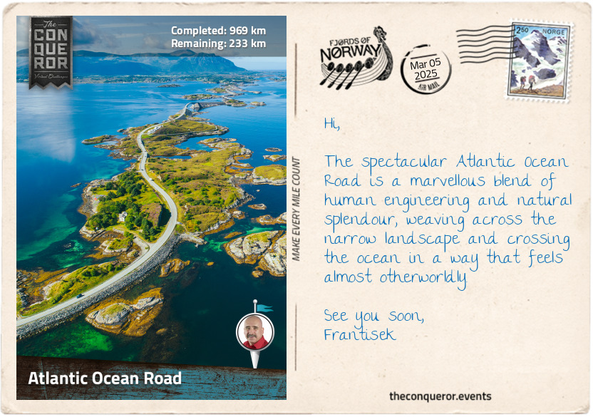
I have excitedly anticipated this part of the journey: crossing the legendary Atlantic Ocean Road. I have heard about it, seen the stunning photos and imagined what it would be like to travel along this narrow stretch of land. Flanked by the sea, connecting one island to the next, this traverse was truly magical. The Arctic salt filled the air, adding to the adventure. The road beckoned to explore and continue discovering Norway's wild coastline.
Known locally as Atlanterhavsvegen, the Atlantic Ocean Road stretches for 5mi (8km) across islets and skerries, connected by eight bridges. While the road itself isn't very long, it's undeniably exciting and captivating. Turnouts are dotted along the way to stop and enjoy the scenery. In a few spots, walkways have been installed to allow for safe walking near the coastal edges. Two such locations are on Flatskjæret and Lyngholmen islands, allowing me to step out and feel even closer to the sea.
One of the highlights of this stretch of road is the Storseisundet Bridge. At 850ft (260m), it is the longest and most iconic of the eight bridges. Its cantilevered design features a fabulous arch with a gradient of 8˚, reaching its highest point 75ft (23m) above the water. As the road curves, the bridge comes into view, rising against the backdrop of the ocean. Seeing it for the first time was breathtaking, and I marvelled at the engineering ingenuity of this whole road.
It was originally planned as a railway to support local fishermen. However, the terrain was extremely challenging and eventually forced a change of course, giving birth to the idea of the Atlantic Ocean Road. Construction started in 1983 and took over six years to complete. The workers had to deal with very difficult weather conditions and even braved 12 fierce storms to bring this incredible route to life.
As I travelled across it, I felt deep admiration for the determination it took to make this possible. The road is now a tourist destination and is hailed as one of the most beautiful scenic drives in the world.
km od začátku : 1046
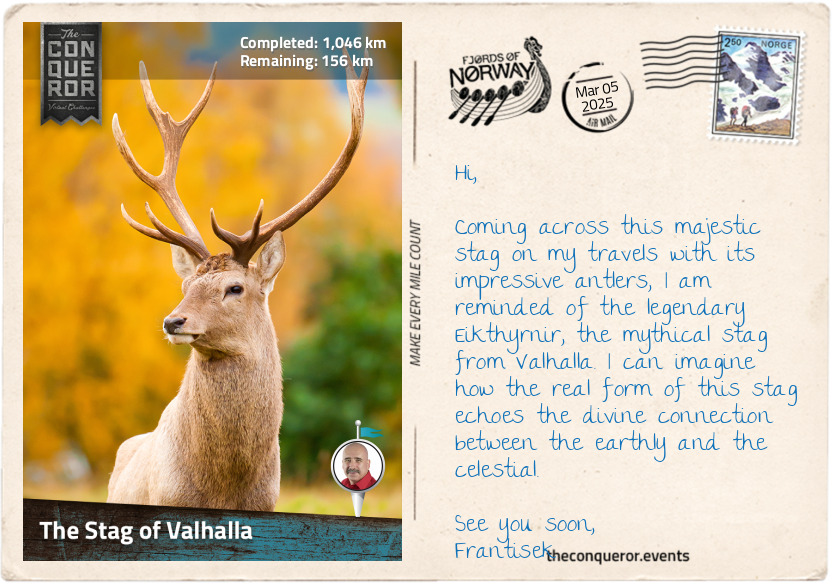
The Stag of Valhalla
No journey through Norway is complete without a story that intertwines the real with the mythological. Who better to draw upon than the red deer, the second-largest deer in Norway, and Odin, one of the most powerful gods in Norse mythology?
The Stag of Valhalla
In the heart of the ancient Norwegian forests, where mist shrouds the land in a veil of mystery, the red deer roams. Known for their impressive antlers, these majestic creatures are revered as the lords of the woodlands. Beyond the mortal realm, however, in the hallowed halls of Valhalla, a different stag roams—a mythical being named Eikthyrnir.
Eikthyrnir, the stag of legends, is no ordinary creature. Its vast and magnificent antlers stretch across the heavens, touching the roof of Valhalla itself while feeding from the leaves of Yggdrasil, the tree of life. The mythical stag's every step sends tremors through the world, its antlers dripping with water that nourishes the rivers and springs below. Eikthyrnir's existence embodies life's sustenance and signifies the connection between fallen warriors and eternal life forces, representing a cycle of renewal akin to their belief in an afterlife.
Odin, the All-Father, wise and enigmatic, watches over both Asgard, the realm of the gods, and Midgard, the realm of humans. He perceives the red deer as a reflection of Eikthyrnir's essence and understands that it symbolises the divine cycle that Eikthyrnir represents.
In a twist of fate, Odin descends from Asgard to the mortal realm in his quest for knowledge and balance. Disguised as a wandering sage, he encounters the red deer in the shadowy woods. To the untrained eye, Odin appears as an old man with a long beard, a wide-brimmed hat and a cloak. But to the red deer, he is a harbinger of destiny.
Odin reveals to the red deer its divine connection to Eikthyrnir, explaining how its existence on earth intertwines with the mythical creature's celestial presence. Though the red deer is unaware of its true nature, it holds within it the essence of Eikthyrnir, embodying the eternal cycle that sustains the world.
Moved by this revelation, the red deer and Odin forge a unique bond. The stag's journey becomes a symbolic passage, linking the earthly and the divine. As it roams the forests, its antlers gain a profound significance, echoing the grandeur of Eikthyrnir's celestial form.
As the seasons shift, the red deer's presence in the forest becomes a symbol of this connection, while Odin keeps a watchful eye from Asgard. So the next time you come across a red deer, think of the powerful Eikthyrnir and its ancient bond with the divine realms.
km od začátku : 1151
Orkanger
Tucked at the end of the Orkdalsfjord, an arm of the larger Trondheimsfjord, lies Orkanger, a town known for its industrial heritage, particularly in hydroelectricity. The town expanded with the development of hydroelectric power plants and the establishment of factories using this energy.
Orkanger played a key role in Norway's railway and steamship industries in the early 20th century. The Thamshavn Line, Norway's first electric railway, opened in 1908, transporting pyrite ore from the Løkken Verk mines to the port at Thamshavn, just outside Orkanger. It served both passenger and freight transport. However, as mining output declined and buses replaced passenger services, the importance of the railway waned. The Thamshavn Line was taken out of service in 1974, but a 14mi (22km) section was preserved and later reopened as a heritage railway.
The town's location along the fjord made it a key port for exporting minerals and goods via steamships, which also provided passenger services linking Orkanger to other coastal communities. One notable vessel was the SS Orkla, a 115ft (35m) passenger steamship completed in 1908. Nicknamed 'Trondheim Fjord's white swan' due to its white finish, the SS Orkla was the fastest and grandest boat in Norway at the time, with a capacity of 342 passengers. It operated twice-daily roundtrips for 40 years until a decline in demand ended its service. The steamship was sold for use on the Congo River but was last reportedly sighted in Peru around 1960.
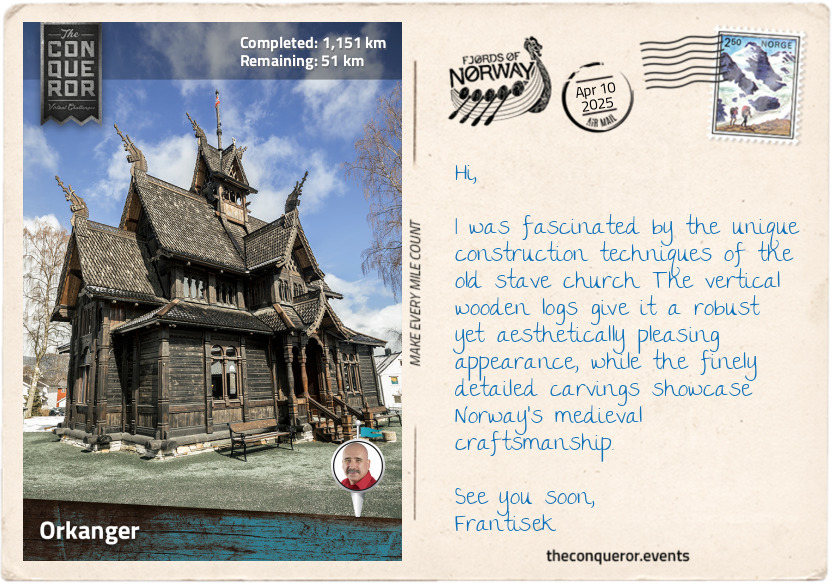
Thamspaviljongen, the "Norway Building", is an intriguing structure with an equally fascinating history. Constructed as a stave church for the 1893 Chicago World's Fair, its design was inspired by the 12th-century Gol stave church currently located in Oslo. Built by 300 local workers within three months, the building was delayed by a broken axle during its transatlantic journey but eventually showcased to around 27 million visitors. After the fair, it was moved many times, serving as a cinema and the main attraction at an immigrant museum before its closure in 2012. In 2014, Olav Sigurd Kvaale, whose grandfather carved the design around the entrance, visited the pavilion and, learning of its uncertain future, initiated "Project Hematt" to bring it back to Norway. After fundraising efforts, the building was dismantled, shipped in three containers, and returned home to Orkanger in 2017—124 years after its original construction.
As I finish my exploration of Orkanger, I look forward to pushing on to my final destination: Trondheim.
km od začátku : 1201
Trondheim
It's been a long journey, and I have now arrived at my final destination in Trondheim. Founded in 997, the city's history stretches all the way back to the Viking Age. Initially named Nidaros and serving as Norway's first capital, the city was established by King Olaf I, great-grandson of Harald Fairhair.
My first stop was Nidaros Cathedral, an 11th-century Gothic masterpiece and the northernmost cathedral in the world. With its intricate carvings and soaring spires, the cathedral is not only an architectural marvel but also a key destination on St. Olav's Ways. This ancient pilgrimage route, which starts in Oslo and traverses the country, culminates here at Nidaros, where King Olaf II, later Saint Olav, Norway's patron saint, is buried. From the Middle Ages, the cathedral served as the coronation church for Norwegian kings, with King Haakon VII as the last crowned in 1906.
Adjacent to the cathedral is the Archbishop's Palace. Dating back to the 12th century, it is Norway's oldest secular building. Now a museum, it tells the story of the cathedral through the ages its many reconstructions, restorations and expansions. Saved artifacts and archaeological discoveries are some of the highlights of the museum. Another smaller museum displays the Royal Regalia, including the crowns of the king, queen and Crown prince, along with ceremonial robes and tells the royal family's history.
From here, I walked to the 17th-century Old Town Bridge, "Gamle Bybro". I passed under the Lykkens portal, a decorative gateway from 1903, symbolising joy and happiness as one enters Trondheim's historic district. Leaning over the railing, I admired the picturesque view of the Nidelva River, lined with traditional timber houses.
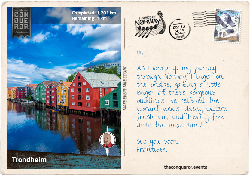
On the other side of the bridge was Bakklandet, a historic district characterised by cobblestone streets and wooden houses, some dating back to medieval times. Café outdoor seating lined the quaint streets, creating a nostalgic atmosphere. Walking through Bakklandet, I saw how Trondheim has preserved its past while embracing modernity, with each corner telling a story.
Amidst these historical landmarks, Trondheim's vibrant student culture adds a lively and youthful dimension to the city. Students comprise almost a fifth of the population, so their influence is significant. The Student Society of Trondheim, founded in 1910, is the largest in Norway and is housed in an iconic round, red building called Samfundet. The building sits prominently near the river and a short distance from the Norwegian University of Science and Technology, the country's largest university, hosting around 36,000 students.
To round up and ponder on my travels from Stavanger to Trondheim, I found myself in a cozy café where I could indulge in one of Norway's favourites—the waffle. Served in a heart shape and topped with just about anything imaginable, from savoury to sweet, I settled on the simple combination of jam and cream, accompanied by a piping hot cup of coffee. While relishing each bite, I contemplated the miles and miles of fjords, mountainous terrain, endless lakes, and delightful towns and villages I had passed through. This is the end of this adventure. I bid you farewell and see you on the next one.