The Grand Canyon is located in northwest Arizona. It is the largest canyon in the United States and is designated a World Heritage Site. Due to tectonic uplift, visible rock layers are between 2 billion years to 270 million years old. Snaking its way through the canyon for 280mi (450km) is the Colorado River. Calm as it may seem, the river is a wild ride through more than 200 rapids, making its way into Lake Mead.
The first people to live in the canyon were Ancient Puebloans. Exploration through the canyon only began in the late 1800s when geologist John Wesley Powell, with a crew of 10 men, launched a river expedition that would last three months.
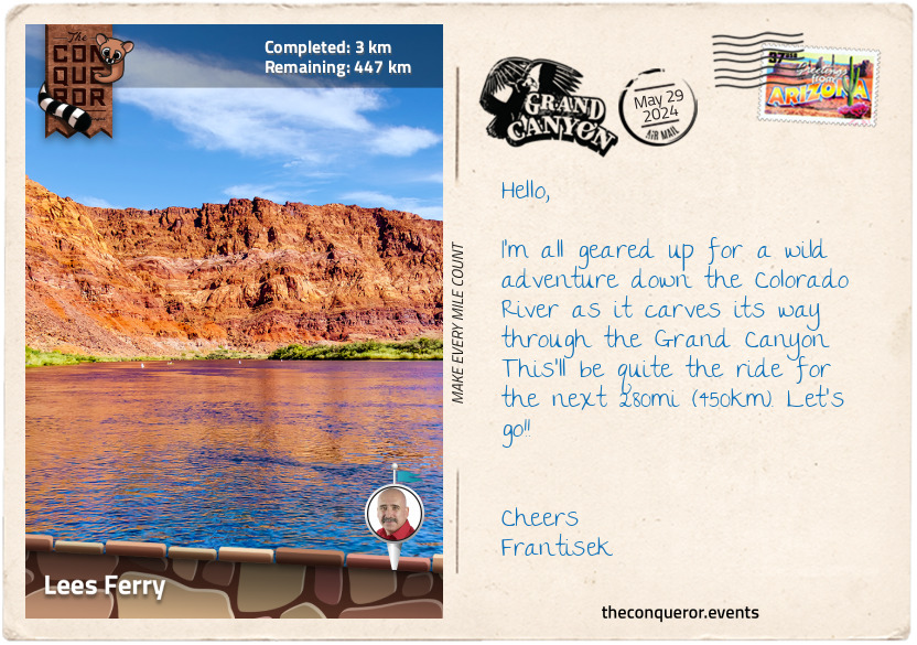
The journey begins at Mile Marker Zero - Lees Ferry, named after John Doyle Lee, an American pioneer who set up a ferry service in 1873. It was ideal for a ferry crossing as the river was accessible from both sides. Operations ceased in 1928 when construction of the Navajo Bridge was completed 4mi (6.4km) downstream.
Today, Lees Ferry is the launching site for river rafting expeditions. It is considered the official start of the Grand Canyon's Colorado River journey.
Boarding the inflatable raft, I settle down, taking in the Echo Cliffs to the east and Marble Canyon to the west. The river is wide, calm and reflective. The landscape is a vermillion hue, with vegetation protruding from the river's edge. The atmosphere is peaceful and tranquil. I push off, heading west. Outwardly, I am calm and relaxed, but inside, I am anxious and nervous as I ride into the unknown of the Colorado River.
km od začátku : 0007
Navajo Bridges
A gentle meander from Lees Ferry turned into the first rapid near Paria Beach. The speed of the water flowing downstream over a combination of hard and soft rocks created mild turbulence in the water. The gentle ripples, small waves and minimal obstructions made for an easy rapid and great first experience.
For the next 1.5mi (2.4km), I rafted quietly on the river, taking in the magnificent canyon with low-lying plants and scrubs dotted along its banks.
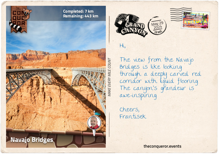
Another mile further (1.6km), I had my first glimpse of the Navajo Bridges, two steel-arch bridges connecting the canyon's rims. Once in full sight, I marvelled at their structure. The two bridges, almost identical in design, were a mere 330ft (100m) apart. The original bridge, built in 1929, was the only vehicle crossing until it became too narrow for modern-day traffic. To alleviate the problem, a second bridge was built in 1995, converting the original into a footbridge.
Large chunks of rock were carved out of the canyon's walls to make way for the bridges' footings. During construction, the engineers installed a large mesh screen to catch any loose rock from blasting. One guide recalls that for a time, they could pass under the bridge only between 11am and 1pm, when the engineers were at lunch.
It took a staggering 6.3 million pounds (2.9 million kg) of steel to construct these sleek and uncomplicated looking bridges. Integrating into the landscape, the bridges continue as an overland link whilst below their shadow provided me with temporary relief from the sweltering heat.
km od začátku : 0029
House Rock Rapid
Rapids are fascinating geographical features and are quite dangerous to inexperienced rafters or kayakers. In the Grand Canyon, rapids are a result of boulders and debris pushed out from side canyons during flash flooding or from rock falls. Using Badger Canyon, a side canyon, for example, imagine an extremely intense rainfall with the water at the top of the canyon pouring down the sides of the canyon walls. The water accumulating on the canyon floor flowed quickly towards its outlet, picking up everything in its path. When it reached the Colorado River, it tossed all the rocks and debris into the river, creating a large pour-over. The natural flow of the Colorado was suddenly interrupted. For a short distance, it turned into a foamy, agitated flow as it smashed its way over the submerged rocks. Once passed, the river resumes its normal meandering flow until, of course, the next rapid.
At mile 10 (16km), I passed what was unsurprisingly called Ten Mile Rock, a massive chunk of rock and prominent landmark that broke off from the cliffs above and tumbled into the river. Not the most imaginative name for such a towering monolith, perhaps no more imaginative than being called "Slab Rock", as it was named by Les Jones on his 1963 map.
An engineer and river runner, Les was best known for his detailed river maps on scrolls of paper strips. The rivers were drawn in great detail from end to end. A river runner using the map would roll the scroll, removing the need to ever fold the map.
Brown's Riffle at mile 12 (30km) was named after Frank M. Brown, President of the Pacific Railroad Company. In 1889, Frank and a party of men were surveying the possibility of a train route in the Grand Canyon to transport coal. Taking a wooden boat with his companion, Harry McDonald, he pushed off from shore and, fairly quickly, hit a whirlpool and capsized. Neither were wearing life vests. Frank sadly drowned while Harry managed to swim to shore. Two other men in the same expedition, also without life vests, drowned five days later further downriver.
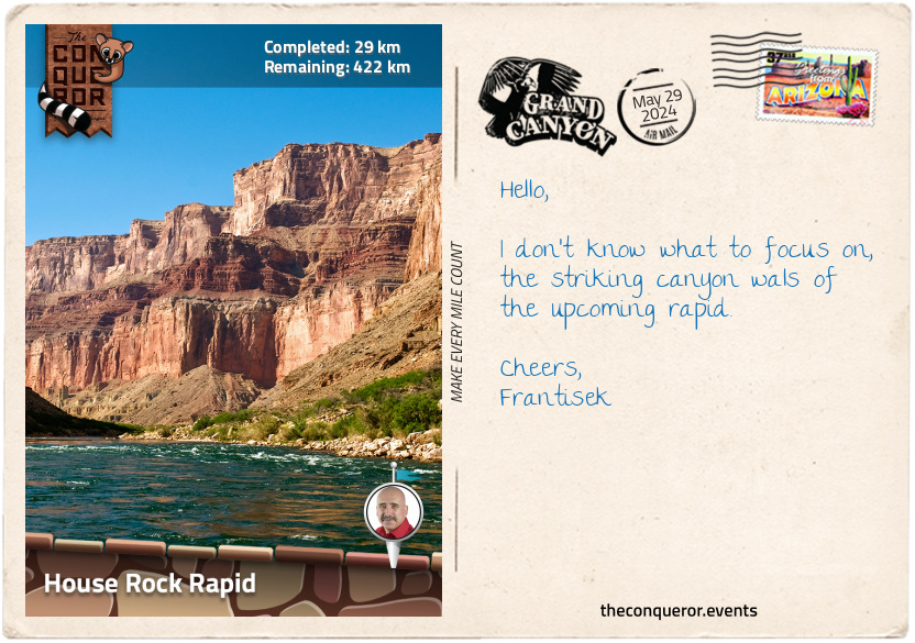
Even before I rounded the bend, I could hear the roaring thunder of House Rock Rapid. Instinctively gripping the raft handles, I prepared for the first serious whitewater. As I entered perpendicular to the current, I had to navigate around the rock bar on the right, the two large holes on the left and through the huge waves ricocheting off the canyon's wall. It was exhilarating, to say the least, for the few minutes it took to bounce through the rapid. Straightening up, I flowed into the calmer water, waiting for the tension to subside. Then, once more, I returned to admire the red cliffs of the canyon.
km od začátku : 0054
Redwall Cavern
Having arrived at mile 20 (32km), I entered what is referred to as the Roaring Twenties Rapids. The cliff-forming Redwall Limestone comes into view as the river cuts through the canyon. At 350 million years of age, the limestone was part of an ancient sea environment, and the fossils of marine life, such as nautiloids, can be found in the rock formations. Rapids are larger and more frequent in these ten miles (16km) stretch, hence its name, the Roaring Twenties.
Around mile 32 (51km), I came across a large patch of vegetation growing up the side of the rock face. Just as I passed it, I could see a gentle spring cascade down the cliff face as it poured out the side of the rock halfway up. This abundance of greenery seemed odd and out of place amongst so much desert rock. The spring, Vasey's Paradise, was named after George Vasey, a late 19th-century Chief Botanist of the US Department of Agriculture and creator of the National Herbarium.
The final bend for the day brought me to Redwall Cavern. An enormous cavern that, before the Glen Canyon Dam (upriver from Lees Ferry), used to flood. When the water receded, it would leave beach sand inside the cavern. Now that the dam is built, it remains relatively dry, providing river runners a great place to rest and shield from the sun or heavy rains. No dimensions can be found regarding the cavern to indicate the enormity of it, but when football or baseball can be played within it, it gives a pretty good idea of how large it is. I could also imagine that on heavy rainy days, sheets of water would pour down the cavern entrance, creating pretty spectacular waterfalls.
km od začátku : 0086
Nankoweap
The Grand Canyon holds wonderful surprises, such as the Nautiloid Canyon. Narrow and steep-sided, the canyon earned its name by containing nautiloid fossils in its rocks. These 400-million-year-old fossils are the ancestors of modern-day chambered nautilus, squid and octopus. With squid-like heads and snail-like shells, the nautiloid fossils reveal themselves when water is poured onto the limestone floor.
A series of rapids unfold in quick succession around a semi-circular bend known as Point Hansbrough, named after Peter Hansbrough, a member of Frank Brown's expedition. Peter attempted to run the 25 Mile rapid, but his boat was pushed against a cliff by the current. When he pushed away from the cliff, the boat overturned, and both he and his companion, Henry Richards, were tossed into the water without life vests and drowned. Henry's remains were never found. However, Peter's were discovered six months later near President Harding Rapid, having been carried 19mi (30km) downriver. His remains were recognised by the clothing and boots found on the skeleton. He was buried nearby, and an inscription was cut above his grave, "PMH 1889".
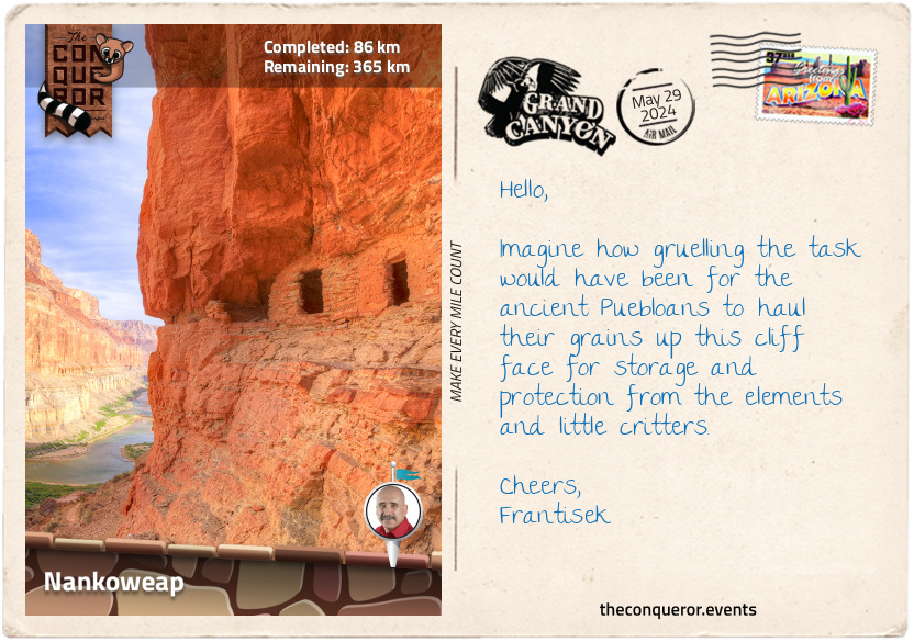
Point Imperial is between Nankoweap Creek and Little Nankoweap Creek. At 8,803ft (2,683m), it is the highest point on the rim. To the left of the Point, built high up from the river, are the Nankoweap Granaries. The Ancient Puebloans wanted a safe place to store their grain and keep it dry when the river rose and flooded the area. They accomplished this by cutting several small square windows into the rockface. It must have been a gruelling task to cut out the rock and haul the grain since the hike up to the granaries was a steep, near-vertical climb of about half a mile (800m).
Not one to back down from a challenge, I tackled the rocky, winding trail, climbing up to the Granaries. With a little bit of light scrambling at the end, I was afforded breathtaking, panoramic views of the meandering river and the variegated colours of the canyon walls.
km od začátku : 0100
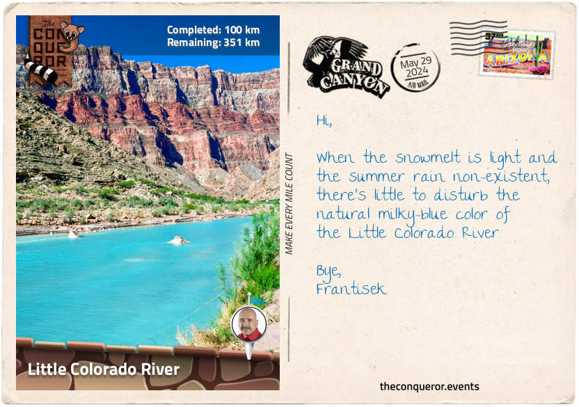
Little Colorado River
As I progressed along the river, I rafted through Kwagunt Rapid. It was not an overly difficult rapid, with average-sized waves, but the current was so strong that it kept pushing the raft toward the exposed rocks. As with any rapid, flipping in the river was not ideal as there was no chance to self-rescue, making the ride bumpy and exhausting. Continuously course-correcting, I made it into calmer water and carried on to the next one, which was quite uneventful.
As anticipated, shortly after the 60mi (96km) rapid, I reached the confluence of the Colorado River with its major tributary, the Little Colorado River. This was the end of Marble Canyon and the beginning of the Grand Canyon proper.
A significant difference at this junction was the water quality and colour change. Up to now, the Colorado River was a cool, clear and blue-green shade. The Little Colorado River was a muddy brown resulting from too much silt due to heavy rains muddying its usually vibrant blue colour.
So here I was at the junction where the green of the main river blended with the murkiness of the little river. The further along I travelled, the browner the river became, leaving the dark green shade behind. The canyon walls were no less impressive, but the murky water was no longer inviting. Perhaps just as well since the water temperature was an average of 48°F (9ºC). I no longer felt the desire for a swim.
km od začátku : 0112
Tanner Canynon
As I entered the Grand Canyon proper, I sensed a change. The canyon became deeper, the river more powerful, more imposing. This is where the advanced rapids awaited my arrival.
Around mile 64 (107km), the lower part of the canyon walls have significant mineral deposits. Known as the Hopi Indian salt mines, this is where the Hopi Indians come to gather salt for ceremonial purposes. A pilgrimage here was also a rite of passage for young males entering adulthood. Considered sacred ground, the area is off-limits to outsiders and rafts on the river are not permitted to stop and explore.
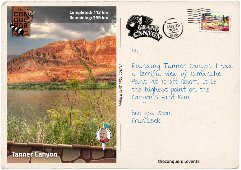
Four miles (6.4km) later, I rafted past Tanner Canyon and through Tanner Rapid. The murkiness of the water was really showing and a far cry from the green colour in Marble Canyon. The rapid was named after the 19th-century prospector and guide Seth Tanner. He was responsible for expanding and improving the Tanner Trail down to the river. Legend has it that the trail was used in the late 1800s to drive stolen horses and, during the prohibition era of the 1930s, likely used by moonshiners (liquor smugglers).
Norm and Doris Nevills were pioneers in commercial river running in the 1930s. Norm was in charge of the river expedition, and Doris was in charge of logistics. Norm was credited with numerous 'firsts' such as being the first person to run through the canyon more than twice, the first to run a commercial run through the canyon, the first to take women on a commercial trip, and the first to take women through the canyon. Norm was also proud that he never flipped a boat on any of his river runs. As prominent figures in Grand Canyon history, they were bestowed with their own rapid at mile 75 (120km), known as Nevills Rapid.
km od začátku : 0133
Grapevine Rapids
I entered the Upper Granite Gorge from mile 77 (123km), where the river exposed rocks 1.7 billion years old. Because the rocks here are harder and slower to erode, it makes the river move faster, and the rapids grow larger. The gorge begins at Hance Rapid and is my first experience of an advanced rapid. Roaring and intimidating, the start of the rapid involves navigating around a bunch of large rocks in the centre, creating huge pour-overs to the left with plenty of holes to the right. Skirting the boulders, I aimed to avoid the big holes on the right, but things don't always go according to plan. A subtle misjudgement had me heading straight into one of the holes, and just as the raft dipped into it, a huge wave washed over me. Soaked through, I was sure this would not be the last time I'd be this wet.
Hance Rapid was named after John Hance, who is believed to be the first non-Native American resident of the Grand Canyon. A Civil War soldier, asbestos miner and Canyon guide, he was largely remembered for his colourful character, tall stories and building the Old Hance trail to the river. Hance was the first person buried in the Grand Canyon Pioneer Cemetery and is now among 400 other graves, including 29 unidentified passengers from the 1956 air disaster that occurred over the canyon.
Two miles later, I headed straight into another advanced rapid, the Sockdolager Rapid, which is long and choppy within the narrow canyon walls. In 1869, Powell's expedition couldn't find a way to portage around this rapid, so they tackled it head-on. When they returned three years later, they called it Sockdolager, an archaic slang term meaning "a forceful blow", possibly what they felt as they paddled their way through it.
After jostling around a few more rapids, I looked forward to our campsite at Zoroaster Camp. It was a small, concave stretch of sandy beach surrounded by rough, jagged cliffs in colours of grey and black. The landscape blended with the murkiness of the Colorado, projecting a very different sight to the usually stunning hues of red and orange. It was wonderful to observe the constantly changing face of the Grand Canyon.
km od začátku : 0159
Crystal Rapids
It's been 83mi (133km) since the last manmade structures when I rafted below the Navajo Bridges. Now, within half a mile of each other, I came across two suspension bridges serving pedestrians. The first one was the Kaibab Bridge, built in 1928 to replace the swinging bridge built seven years earlier. It is often referred to as the "Black Bridge" and spans 440ft (134m) across the river, connecting the North and South Kaibab Canyon trails.
The second bridge, Bright Angel Bridge, also known as Silver Bridge, was completed in the 1960s. Aside from connecting the two sides of the river, it also supports the trans-canyon water pipeline suspended beneath the bridge. The pipeline pumps 500,000 gallons of water daily from Roaring Springs near the North Rim to the tourist area on the South Rim. Several sections of the pipeline can be seen along Bright Angel Trail.
Following two easy-going rapids, I encountered one of the more difficult ones in the canyon, Horn Creek. Although short, it was also very steep, dropping into a series of waves and holes. A huge sinkhole is to the left of the rapid's start. I entered to the right, navigating around big waves bouncing off a submerged ledge. Steering left, beyond the sinkhole, I crashed through oncoming waves, getting soaked all over again. It was a fast, heart-pumping thrill.
The rapid was named after Tom Horn, a late 19th century US Army Scout who was the main interpreter during the surrender of Geronimo, leader of the Apache people. Later, he became a detective, taking it up when all his cattle were stolen one night from his ranch, bankrupting him, then a Pinkerton agent due to his tracking abilities, and finally, a gun for hire for which he paid with his life when he was found guilty for killing a teenage boy and hung. To this day, his guilt/innocence continues to be debated because the investigation lacked detail and insufficient evidence, and he made his confession while inebriated.
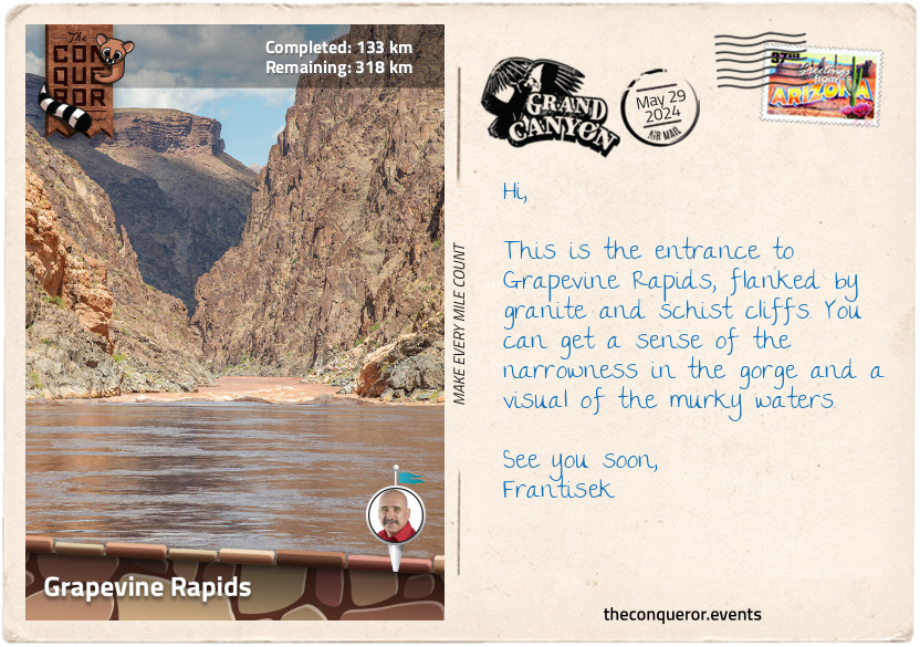
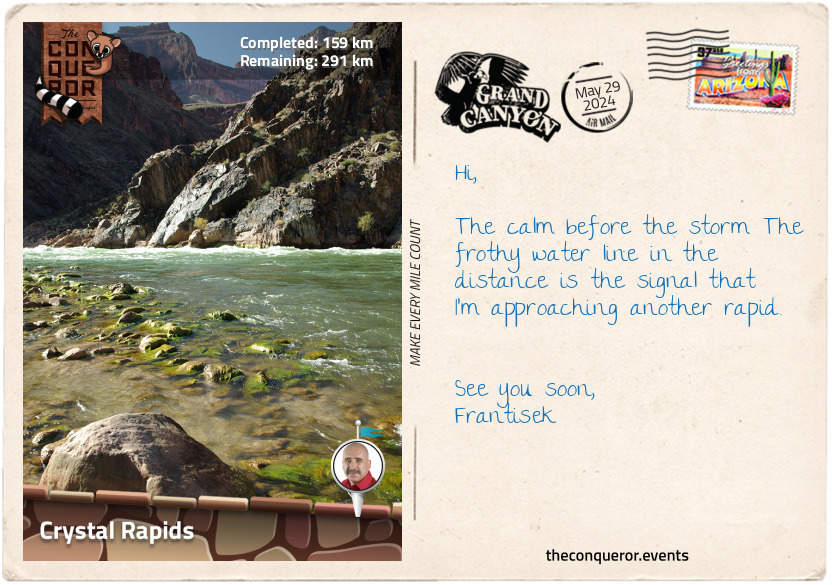
More intense rapids ensued with Grapevine, Hermit and Crystal. Each has its own hair-raising characteristics. There's always something to look out for: strong currents, sinkholes, and twisting waves, but with Crystal, there's the added rock garden in the middle of the river where a raft could get pinned or the small whirlpool near one of the rock walls that almost guarantees a flip. I navigated through the left of the rock garden, keeping it tight through the centre as I rode the waves out of the rapid, avoiding the big holes. With each intense moment, I doubly appreciated the calm that followed.
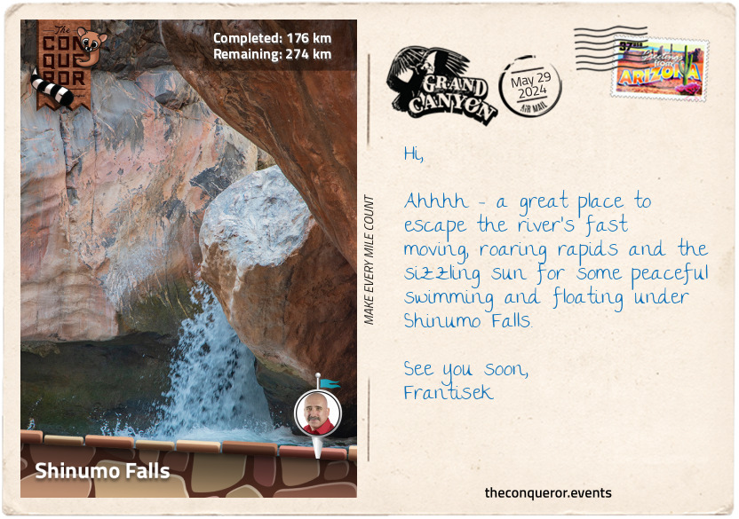
km od začátku : 0176
Shinumo Falls
A sharp turn brings me to Willie's Necktie Rapids (100mi/160km) and its interesting story. In 1950, Willie Taylor's motorized boat got pinned against the rapid's wall, tossing him into the river. His buddies threw him a line that, unfortunately, wrapped around his neck. Focused on reeling him in, they pulled on the line around his neck, cutting off his air supply. Luckily, once pulled into the boat and his 'necktie' loosened, he could regain his breath and live to tell the tale. Dying of a heart attack on the Colorado six years later, his friends, upon his final request, buried him in a small side canyon not too far from Peter Hansbrough (see postcard 4). He and Peter are the only two Grand Canyon river-runners known to be buried in the canyon.
At the tail-end of the rapid, right in the centre of the narrow river, was a massive rock the size of an apartment. Taking a left approach, I nearly overlooked the smaller rock jutting out of the water once I passed it. I'm sure it's caught the occasional unsuspecting runner. The large rock was named after US President Nixon, and the smaller one after his Vice President Spiro Agnew. Both men were caught in political scandals in the early 1970s and resigned from office within a year of each other.
The next lot of rapids are known as the Gem Series, with names such as Agate, Sapphire, Turquoise, Emerald, Ruby and Serpentine. Although smaller than Horn, Granite, Hermit and Crystal upstream, the gem rapids can be tricky during low water when boulders surface, creating more obstacles. River runners often scout the rapids from the shore before tackling them because changing river conditions, such as high or low water levels will also change their intensity.
Having made it to Shinumo Creek, I took a very short hike through the narrow canyon, wading through the shallow creek until I arrived at a small waterfall with a pool below it. A wonderfully clear waterfall and warmer than the Colorado, it was a great place to escape the sun and float around the pool relaxing.
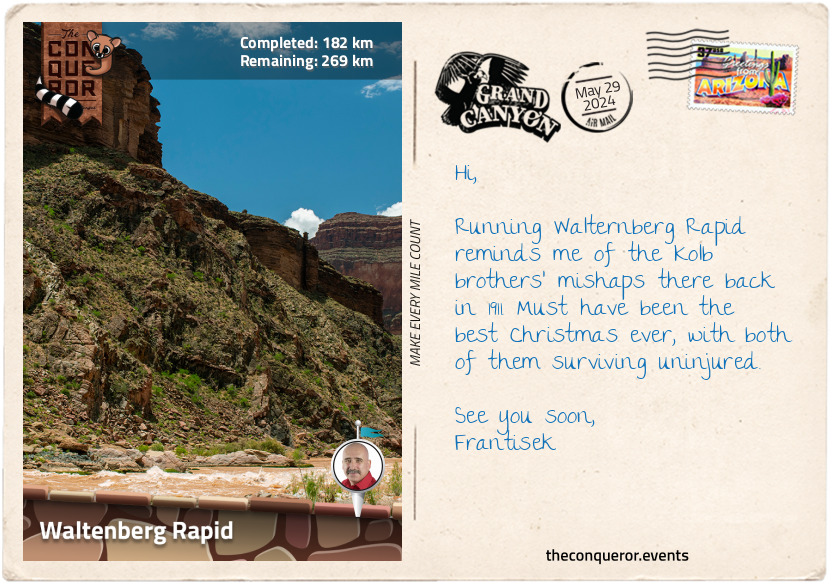
km od začátku : 0182
Waltenberg Rapid
Way before the Grand Canyon became an organised tourist destination, it attracted some very colourful characters, none more interesting than Emery and Ellsworth Kolb. They were brothers, professional photographers, daredevils and major contributors to the Grand Canyon's designation as a National Park.
On 19 December 1911, the Kolb brothers launched their wooden boats, Edith and Defiance, onto the Colorado River, intending to photograph and film the interior of the Grand Canyon. Five days later, on Christmas Eve, each with their own boat took a chance on the Waltenberg Rapid. Choppy, moody and referred to as "bad" by Ellsworth, the end of that day was possibly the best pre-Christmas Day present ever.
When they approached the rapid, each took a different course – Emery chose the right, and Ellsworth chose the left. It didn't take long for Emery to find himself stuck. He wrote, "I scarcely started when I found myself on a nest of jagged rocks, with violent water all about me, and with other rocks, some of them submerged, below me. I climbed out on the rocks and held the boat…The greatest trouble would be to hold the boat if she broke loose."
Ellsworth, on the other hand, found himself in a whirlpool "bouncing back and forth like a great rubber ball". As his boat filled with water, it sank and overturned, with Ellsworth still holding on. Once he let go, the strong current pushed Ellsworth through the rapid, bobbing up and down, submerging with each breaking wave.
As his life vest barely kept Ellsworth above water, Emery pried his boat loose off the rocks. Launching in the centre of the rapid, it wasn't long before he hit rocks once again. His boat broke "like egg-shells" and left a gaping hole on its side. His rescue effort was done for.
Fortunately, Ellsworth was drawn out of the centre of the whitewater into a calm part of the river. Knowing he had limited time before the current would push him downstream into another rapid, he mustered his strength and dragged himself out on his hands and knees. Emery eventually reached him and helped him out of his frozen clothes and into dry blankets.
Their companion, Bert Lauzon, was spotting the pair from shore. Seeing Ellsworth's boat caught in an eddy, he swam out and rescued it before it entered the next rapid. The next day, the trio celebrated Christmas by repairing the gaping hole in Emery's boat and then continued their adventures.
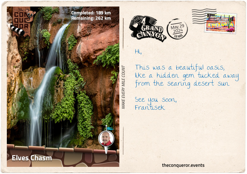
km od začátku : 0189
Elves Chasm
A mile after Waltenberg Rapid, I came across a pile of large rocks slightly to the left of the river's centre. The geology was fascinating here and vastly different from further upstream with its combination of igneous and metamorphic rocks.
Once past this section, the river settled down, and I could enjoy its slow meander through the canyon. Before taking the next bend, I briefly stopped at Elves Chasm for the promise of a lovely horsetail-shaped waterfall and a refreshing pool to swim in. The waterfall gently cascaded down the rock face amongst long tendrils of hanging greenery.
At the top of the chasm was the Royal Arch, a spectacular rock archway carved by water with a thin stream running through it, forming the waterfall in the chasm below. Next to the archway was a vertical column about 100ft (30m) tall, much like the Old Man of Stoer in Scotland. Where the Old Man is forever watchful at the water's edge, this one was standing on the side of the canyon's wall. The arch created a picture-perfect frame when the vertical column was composed in its centre.
km od začátku : 0221
Deer Creek Canyon
The next dozen rapids were a series of easy to medium intensity. Around mile 127 (204km) was Randy's Rock, a huge slab of sandstone partially submerged to the left of the river. The rock was named after a young commercial guide who, in 1976, took a nap on his rig while one of his passengers was left in charge of rowing it. Sure enough, Randy was woken when his rig collided with a massive rock. The river's force wrapped the boat around the rock, tossing its passengers and some of the gear into the river. The remaining gear got caught underneath the undercut of the slab, dragging the boat below water level.
Unable to free the boat from the rocks, the expedition party exited the river and hiked to the nearest campsite with whatever items were recovered. At some point during the night, the boat freed itself and was salvaged. Unfortunately, the frame of the boat was damaged beyond repair and left to sink to the bottom of the river. The tubes were deflated for later extraction.
The expedition continued to the end of its journey on other rigs. You could imagine the company owner's dismay when the party reached the end and was told that one of his rigs had been lost because the guide had taken a nap.
Deubendorff Rapids is known for its many large holes and pour-overs. It was named after Seymour Deubendorff, who in 1909 was the first person to flip his boat in it. In his journal, Seymour described riding over waves, and when his boat came into one of the trenches, the rear hit a rock, capsizing him. When he surfaced, he struck his head on the boat. He attempted to swim to shore but was carried downstream, mostly submerged, only catching his breath between waves. Finally, he was rescued and to his great satisfaction, so was his cap.
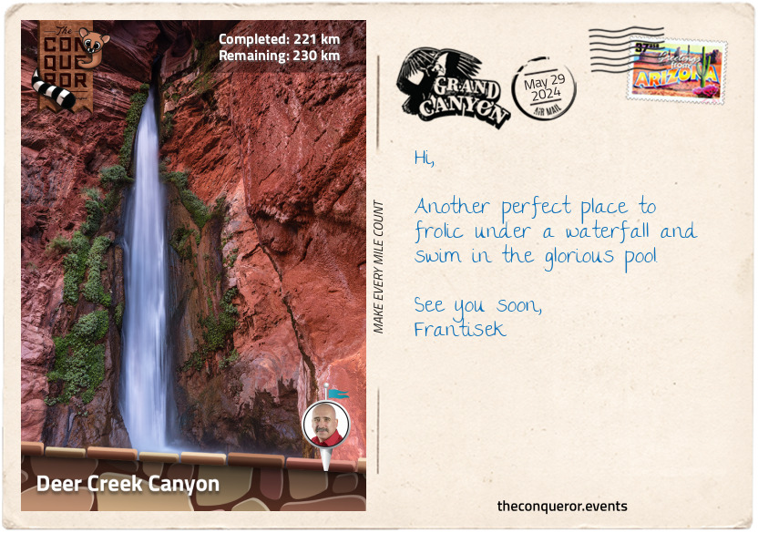
Arriving at Granite Narrows, I travelled through the narrowest section of the river. At 76ft (23m) wide, it indeed felt quite narrow. Within these narrows was Deer Creek Canyon, and at the end was the spectacular site of Deer Creek Falls, plunging 126ft (38m) from above into a shallow pool below. Another opportunity to refresh myself with a swim, I leaned against the ancient rocks and pondered that in less than 3mi (5km), I would have reached the halfway point.
km od začátku : 0289
Lava Falls Rapids
Now I can imagine that in 1923 when Emery Kolb "upset" his boat (a term used back then meaning flipped) by hitting a steep hole in the centre of the rapid, he indeed might have been upset. Lucky for him, Frank Dodge, another boatman and great swimmer, jumped in and retrieved the boat. Since the rapid had no name, it was immediately bestowed with Upset Rapids.
After so much murky water, the milky-blue Havasu Creek tucked within Havasu Canyon was a welcome sight. Havasu Creek is the second-largest tributary of the Colorado River. It is home to several spectacular waterfalls and many pools to swim in. The incredible blue colour was such a contrast to the brownness of Colorado. Even more fascinating was the defined line where the two rivers met, with pale blue on one side and murky brown on the other.
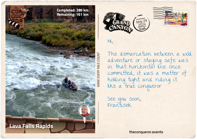
A gentle cruise followed for several miles with a few mild rapids until I came across the most advanced one on this journey in the form of Lava Falls Rapid. In the centre of the entry point was a huge ledge hole with turbulent waves crashing into the hole. The strong current pushed around the sides of the ledge. Fierce lateral waves seethed and frothed, seemingly ready to gobble me up.
A feeling of trepidation hit me as my raft headed straight over the ledge into the hole. With the raft tilting to the right and partially submerged, the force of the oncoming wave was enough to flip the raft over and launch me into the river. The raft, caught in the water's turbulence, was tossed around and around like a spit roast spinning out of control. In the meantime, I surfaced and bobbed up and down, riding the waves, letting the current carry me forward and out of the rapid. Once the raft cleared the hole, it followed me downstream, where I was able to climb back onboard. As adrenaline coursed through me, making my ears ring, I was delighted to have come out unscathed. This rapid may be super short, but it packs a punch in those few seconds.
km od začátku : 0364
Diamond Peak
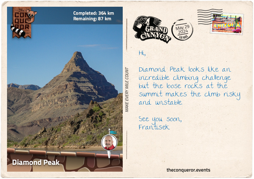
Around mile 216 (346km), I entered the Lower Granite Gorge, where the canyon closed in, narrowing the width of the Colorado. The rapids were easy and uncomplicated, passing the occasional small rock piles in the middle of the river and a handful of islands.
The canyon seemed to have softened with more vegetation present and less imposing layers of rock, except for the pointy Diamond Peak that I could see for miles before I reached it. Adjacent to the peak was Diamond Creek Beach. A wide sandy beach, it had several permanent concrete tables with benches, each with a metal cover above it to shield them from the sun. From here, I had a perfect view of the craggy peak.
As the first place accessible to vehicles since Lees Ferry (mile 0), Diamond Creek is a popular spot for day-trippers and river runners to end their trip or start the shorter route downstream.
Diamond Creek Canyon is prone to flash flooding during monsoon season and often washes parts of the road away. In the summer of 1984, some river outfitters headed up the canyon in their trucks. When one of the vehicles got stuck in loose gravel, everyone hopped out to help free it. Then, the rumbling came. At first, thinking it might be a plane or thunder, imagine their surprise when 100 yards (90m) away, a 10ft (3m) wall of water filling the canyon raced towards them. With only seconds to spare, everyone bolted up the cliffs, barely escaping. Fortunately, no one was hurt, but the guides spent several hours stuck on a narrow ledge waiting for the water to recede and be rescued.
The water was so forceful that the trucks were pushed into one another, rolled into the river and submerged while the gear floated away. A lot of the equipment was recovered 20mi (32km) downstream in Lake Mead a few days later. One of the rafts was found 29 years later in the lake. When the water is low, one of the trucks becomes visible in the river not far from Diamond Creek.
km od začátku : 0372
Pumpkin Spring
Having flipped and survived Lava Falls, the next few rapids were a walk in the park in comparison. Although Kolb Rapids wasn't as scary anymore, it did bear more history about the Kolb brothers. This adventuring duo had a grand plan to row the entire 1,100mi (1,760km) of the Green and Colorado Rivers, even though they had no whitewater experience.
In September 1911, they launched their boats from Green River, Wyoming. Over four months, they rowed, portaged, flipped, swam freezing waters, patched and repatched their boats until they emerged from the Grand Canyon in January 1912.
in the middle of the river and a handful of islands.
Throughout this expedition, the brothers photographed and filmed their experiences, which they played in their studio every day for the next 60 years, personally narrating until Emery died in 1976 at 95 (his brother passed away in 1960).
in the middle of the river and a handful of islands.
Filled with enthusiasm, the brothers also established Kolb Studio in the Grand Canyon, where they would photograph tourists on the trail. Due to water scarcity, they would hike 4mi (6.4km) down to a water source to develop their prints, then back up to sell the photos to the tourists on their return trip. Both brothers were incredibly dedicated, but differences began to strain their relationship as time passed until Ellsworth eventually left. Emery continued to live in the Grand Canyon until his death and was then buried in the Grand Canyon Pioneer Cemetery.
in the middle of the river and a handful of islands.
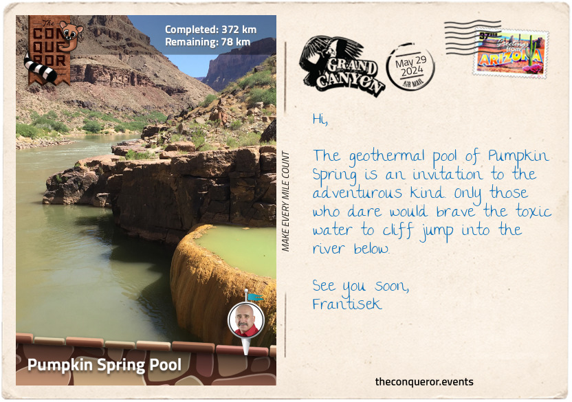
After a couple more rapids, I arrived at Pumpkin Spring Pool, a geothermal pool on the side of the river. Shaped like a pumpkin with its lid removed, the spring's attraction was the river's deep water, and the chance to cliff jump into it. As for the pool itself, it was best to avoid bathing in it. Unlike other amazing hot springs found in Arizona, this one was filled with toxic water and high levels of arsenic. With that in mind, I snapped a few photos and chose to appreciate it from afar.
km od začátku : 0374
Honeymoon Rapid
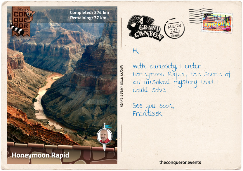
I always like an interesting story, so here's another one: part true, part theory. At mile 232 (371km), also called Honeymoon Rapid, is where Glen and Bessie Hyde likely disappeared in the early winter of 1928. Newly married, the couple set out on their honeymoon adventure trip from Green River, Utah. When they reached the Grand Canyon, they hiked out for supplies and stopped at Emery Kolb's studio to take a photo. Emery offered them life vests, but they declined.
When they didn't arrive at their destination on their scheduled date, Glen's father organised a search party. The Kolb brothers, who assisted in the search, found the Hydes boat with all the gear intact but without the couple. Amongst the gear was Bessie's journal with an entry indicating that they cleared the rapid before Honeymoon Rapid and then no further entry. So, what happened to them?
Their disappearance was never solved, but some theories took hold. The first one was by Georgie Clark, a well-known river runner, declaring some 40 years after the event to fellow rafters that she was the real Bessie Hyde and that she killed her husband after a disagreement. She later recanted her story, and upon her death, her home was inspected. Several dubious items were found, but it was decided that the evidence was inconclusive once investigated.
Another theory that floated around was that after Emery Kolb died, a skull with a bullet hole in it was found amongst Emery's belongings. It was theorised that it might have belonged to Glen Hyde. Thanks to advanced forensic science, it was concluded that the skull belonged to an unidentified person who died in 1933.
The final theory that seems most plausible was that the Hydes hit submerged rocks and had fallen out of the boat into the freezing cold water (it was winter). Having declined the life vests Emery offered earlier, they were possibly swept downriver and drowned.
Their bodies were never found, and the case remains a mystery.
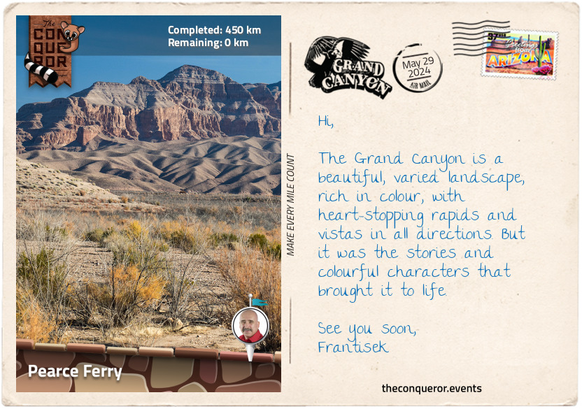
km od začátku : 0450
Pearce Ferry
As I flowed through the remaining rapids, I sensed the end was near. I absorbed whatever stories were left to tell, and here's one final one about Lava Cliff Rapids (not to be confused with Lava Falls Rapids from earlier). In the early 1900s, the Lava Cliff Rapids were considered the most formidable in the Grand Canyon, illustrated by their tumultuous and forceful currents and frothing waves. When the Kolb brothers ran the Colorado in 1911-12, they opted to portage to bypass the rapids. So did Julius Stone's expedition in 1909 and Otis Marston's in 1923. However, in 1937, as part of a scientific expedition, Frank Dodge, the lead boatman, braved the rapid in a homemade wooden boat and succeeded in conquering it.
Today, you wouldn't know the rapids were ever there. They disappeared in the 1930s when Lake Mead's water levels rose.
Rounding the bend at Dry Canyon, about half a mile further (800m), was a short canyon on the left where, at the top, I could just make out the Grand Canyon Skywalk, a U-shaped cantilever bridge with a glass floor that juts out from the canyon wall. Suspended in the air, the view through the glass floor is a 500-800ft (150-240m) vertical drop into the canyon below.
Three miles (5km) before Pearce Ferry, the walls of the Grand Canyon came to a sudden end, and the wonders of the canyon finished. Leaving the desert canyon behind, the Colorado River continued for the remainder of its journey, spilling into the Gulf of California.
I finished my Grand Canyon adventure at Pearce Ferry, the furthest take-out point on any Grand Canyon River expedition.
When I began this journey at Lees Ferry, I didn't know what to expect beyond steep canyon walls and hundreds of rapids. The Grand Canyon is much more than a spectacular geologic formation. It is filled with stories of ancient people who occupied it and pioneers who explored it. It is full of brave explorers who tackled it, scientists who wanted to understand it, photographers who wanted to capture its essence and travellers who wanted the thrill of the experience. Stories have abounded since its early sighting, be they stories of triumph, disaster, or mysteries. Now, I can add my story to it, too.