I have arrived in Victoria, the second smallest state in the southeast corner of Australia, and I am here to tackle the 149mi (240km) challenge along Great Ocean Road, one of the most spectacular coastal drives of Australia. This journey from Torquay to Allansford will take me through small seaside towns, along the Shipwreck Coast, through the Otway Ranges and by some of the most unique and famous landmarks.
Great Ocean Road is on the south-west coast of Victoria and is famed for being the largest war memorial in the world. The road was built by 3000 returned WWI servicemen as a way to connect sparsely populated areas and provide a transportation link to the timber industry. Construction took 13 years as it was built by hand using explosives, picks, shovels and wheelbarrows with very little machinery. The wilderness was so dense they could only progress a mere 1.8mi (3km) every month. It was quite a dangerous job due to the use of explosives, and unfortunately, it was not without fatalities.
In 1939 they built a memorial arch across the road at Eastern View to remember the fallen soldiers. The arch was rebuilt several times, and there were plans to tear it down because they thought it was a driving hazard, but it was swiftly shot down as it was considered a sign of disrespect to the returned soldiers. There's also a sculpture on the side of the arch of two soldiers working on the Road.
Besides being a popular tourist destination, the Great Ocean Road is an Australian National Heritage Site and carries the Engineering Heritage National Marker awarded by Engineers Australia.
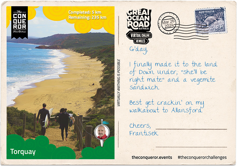
Leaving history behind, I reached Torquay, a seaside town named after the holiday resort in Devon, England. Torquay is known for its: surfing beaches; surfing brands Rip Curl and Quiksilver; the longest-running surfing competition; surfing museum; and famous Bell's Beach. In a nutshell, Torquay is all about surfing and is considered the surfing capital of Australia.
Back in 1962, a bunch of locals decided to host the first official competition known as the Easter Classics. The competition became so popular throughout the 1960s that it drew surfers from all over the country.
It was around this time that local surfing duo Doug Warbrick and Brian Singer started their surfing brand Rip Curl, focusing on manufacturing surfboards and not long after, due to the cool oceanic climate, developed dedicated surf wetsuits. Within a few short years, Rip Curl's success accelerated and formally took over the Easter Classic, turning it into Australia's first professional competition known as Rip Curl Pro. The event winner is awarded the prestigious 'Bell' trophy that is steeped in its own history. Legendary local surfer Joe Sweeney was known for two major things. One, for carving out the track to Bell's Beach in 1960 and then charging his mates one pound each (that's before decimal currency was introduced) to cover his costs and secondly, for creating the first Easter Classic trophy with its brass bell hanging from the mount and making all the rest of the trophies for the next 53 years until his death in 2016.
So much surfing history abounds in this country that the Australian National Surfing Museum opened its doors in 1993. The museum is the largest of its kind in the world and the only accredited surfing museum. Its objective is to tell the story of Australian surfing through displays, its Hall of Fame recognising individuals who contributed to the sport, and collecting and preserving relevant documents and items. The museum is recognised by the International Surfing Association as one of "the most significant centres of world surfing heritage".
Of course, I can't leave Torquay without a wander down to Bell's Beach. It was named after William Bell, a master mariner who owned property there since the 1840s. Besides being part of the international surfing circuit, it was made famous in the movie Pointbreak (1991). Funnily enough, the last scene in the movie of a wild beach makes reference to Bell's Beach, but the scene itself was never filmed on Bell's Beach it was filmed in Oregon, US.
After a decent tucker of fish and chips and a pot of coldie, I'll be on my way to Lorne. Write to you soon.
km od začátku : 0045
Lorne
I made it to Lorne, and I wasn't quite sure where to start. For a small seaside town, although it does explode in population during high season, it has a plethora of activities, waterfalls, galleries, shipwreck stories and, of course, more surfing beaches.
Lorne was named after the Marquis of Lorne, Scotland, on the occasion of his marriage to one of Queen Victoria's daughters. It is widely known for its art community. Each year it puts on the Falls Music and Arts Festival and also the Festival of the Performing Arts, but the more interesting one is the foreshore exhibition every two years of public artworks as part of the Lorne Sculpture Biennale.
All year round, there's something happening in Lorne. In May, you have the Great Ocean Road Marathon, which starts in Lorne and winds its way to Apollo Bay. It's a challenging race not just due to its hilly course but also due to its 27mi (44km) length. If the marathon is too daunting, then there's always the three-quarter mile (1.2km) Pier to Pub swim, which has been going for 40-odd years. It's the largest ocean swim in the world, with as many as 4,000 competitors. In 1998 it entered the Guinness Book of Records with 3,071 swimmers. Put on your swimming trunks and hit that nice cold southern ocean.
Between June and October, the Southern Right Whales begin their migrating journey along the southern coast of Australia towards the Indian Ocean to breed and raise their calves before returning to Antarctica. Sometimes you can even spot humpback whales and blue whales.
The town itself is a heritage delight, with several buildings acquiring the Victorian Heritage designation. A visit to the Heritage Centre run by the Historical Society tells the story of the "diggers" who built the Great Ocean Road and the history of the local indigenous people and early European settlers.
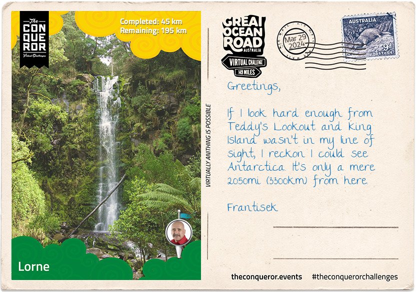
Thinking I was done with the town, I popped in at the Visitor Centre to discover that within 10km of Lorne, there are at least 10 waterfalls to be explored. The most well-known is Erskine Falls. At 30m tall, it sits nestled amongst a fern gully. Another lovely one is the Kalimna Falls which follows the route of a timber tramway used for transporting timber in the 1890s and 1920s. You can stand behind the falls and look through them like a curtain to the large pool surrounded by mossy logs and rocks.
A walk up to Teddy's lookout gives views of St George River and the coast that tells the story of a four-masted barque named, Hinemoa, which ran aground in 1908. Thinking they were reaching Melbourne, they soon realised the lights they saw in the distance were burning logs from a bushfire. Luckily the barque wasn't damaged and was towed off the next day. However, the story of the Osprey is shrouded in mystery. This three-masted schooner is said to have wrecked in 1854 due to heavy storms but the rumour is that it was deliberately run aground by the crew so they could run off and make their fortune in the newly discovered goldfields. The truth will never be known, but it sure opens up the appetite for the stories yet to come on the Shipwreck Coast of the Great Ocean Road.
km od začátku : 0090
Apollo Bay
The first people of Apollo Bay were the Gadubanud Tribe, indigenous Aborigines of the state of Victoria who occupied the surrounding rainforest plateau and rugged coastline. With the ever-expanding mid-19th century colonisation, it is believed the tribe became extinct fairly quickly. There are varying stories from the late-1800s that describe their possible extinction, such as being wiped out when neighbours set the forest on fire, and they suffocated. Another tells the story of surveyor George D. Smythe who encountered the tribe, and when one of his people was killed, Smythe retaliated with muskets and tomahawks leaving no survivors. Very little was documented at the time about this tribe. What is known is mainly what historians have been able to piece together through research over time.
In the 1840s a whaling station was established on the western end of the bay which was named Apollo Bay by Captain Loutit who on a trading voyage to Portland sheltered his schooner, the Apollo, from a storm.
The area around the bay was settled in the 1850s by timber cutters and named Middleton. Unable to build a suitable pier in the bay, the sawn timber had to be dragged to the shore and then floated 328ft (100m) out to sea through the waves to be loaded on ships. High winds from the sea made loading dangerous, causing many ships to be washed ashore or sink. The town opened up to farming, and by the 1870s, blocks of land were available for sale, a post office sprung up, followed by a school. The town was renamed Krambruk in 1881 and then renamed again to Apollo Bay in 1898.
As I forge along the Shipwreck Coast, I came across the disastrous story of the SS Casino. In 1932 on the eve of celebrating its 50th anniversary, Casino approached the pier in heavy swells and struck the seafloor several times. After a failed attempt to reach the pier, the Captain then tried to beach the ship, but it tilted to one side and capsized losing ten lives of the 17 passengers and crew. Whilst the locals made every attempt to help, including a farmer who rode his horse into the surf, in the end, they helplessly watched the tragedy unfold. It was later discovered that the anchor's fluke had pierced the forward hull causing the ship to sink. The ship lying in nine meters of water a quarter mile (400m) from shore is now a diving site and part of the Shipwreck Underwater Discovery Trail.
km od začátku : 0114
Hordern Vale
I've reached the halfway point and the spectacular giant forest of the Otway Ranges. The Otway demarcates the east and west side of the Great Ocean Road. It is part of the Great Otway National Park which covers a total area of 254,980 acres. In 2004 five State Parks and several Crown Lands were combined to make the National Park, and it stretches from Torquay to Princetown.
For 150 years, the Otway was an important source of timber for the logging industry. Since transport and access were limited due to the denseness of the forest, a narrow-gauge railway was built in 1902 to transport timber from the numerous sawmills that sprung. The railway serviced the industry for the next 60 years, and in 1962 it ceased operations and converted into a 28mi (45km) walking and cycling path known as The Old Beechy Rail Trail.
The Otway is a diverse landscape with tall forests, fern gullies, waterfalls and lakes in the north and rainforest in the south, but 106 million years ago, the coastline was part of the Antarctic circle and home to the Leaellynasaura and Timimus dinosaurs. Just like many of Australia's unique animals, the Leaellynasaura is the only known species.
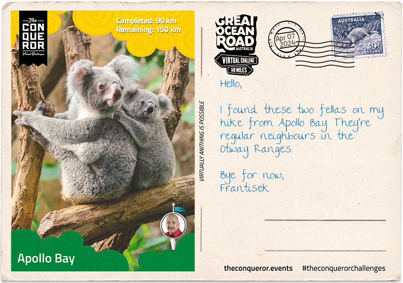
Whilst I'm on the topic of unique animals, the Otway is also home to kangaroos, echidna, platypus and the delightfully soft and furry koala. I just had to look up in the trees, and I would inevitably see a snoozing koala wedged between the branches. These fellas spend up to 19 hours a day sleeping, probably because they're tuckered out from the slow process of chewing on gum leaves, their source of food but don't underestimate them. They may look cute and cuddly, but they are extremely agile and be mindful of those claws.
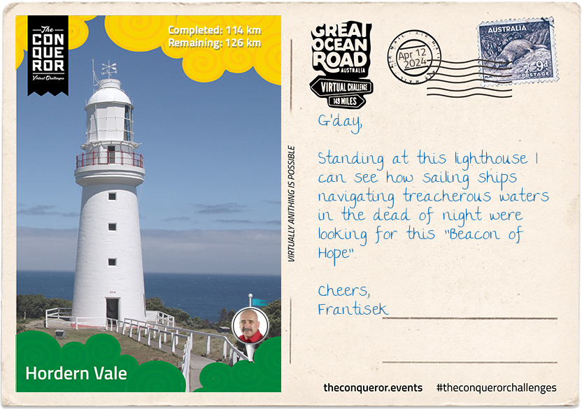
At the tip of the Ranges is the heritage-listed Cape Otway Lighthouse. Built in 1848, it was the second lighthouse built on mainland Australia and remains the oldest surviving lighthouse on the mainland (Tasmania, an island state of Australia, has the oldest surviving lighthouse). The Cape Otway Lighthouse was known as the "Beacon of Hope".
Wind back the clock to the 19th century. Imagine yourself aboard a ship having left your home many months ago, travelling halfway around the world through heavy swells, with diminishing food and water supply, with what would feel like no end in sight. As your clipper rounds the Cape of Good Hope, you truly hope your Captain has excellent navigational skills so when he catches the strong west-to-east prevailing winds, he can successfully navigate the final leg of your journey whilst dodging icebergs, steering through wild seas and fierce storms. As the clipper reaches the coastline of Australia, your very first sight of land is the cape and the lighthouse, giving you hope that the end of your sea journey is finally near, and that's assuming that the Captain succeeds in navigating the narrow pass between the mainland and King Island. Many ships were lost due to miscalculations and hazardous weather, hence the Shipwreck Coast.
Of course, no letter is complete without another shipwreck story. This is the story of Eric the Red, no not the story of the Norseman who discovered Greenland but of the wooden sailing ship that was obviously named after him. Eric the Red was built in 1871 in the United States with a coal trading route between Britain and South America. In 1880 it was chartered to carry a full cargo of merchandise to Melbourne for an international exhibition. After 85 days at sea, on a hazy and moderately windy day, the ship was nearing Cape Otway when it suddenly bumped and ran into the Otway Reef. Following a second bump and high waves, the ship's wheel ropes and the man at the wheel were carried away to sea. A third bump ripped away the rudder, at which point the ship just simply broke up and, in the space of 12 minutes, sunk. Clinging to floating wreckage and cargo, it was sheer luck that a nearby steamer, SS Dawn, saw the distress signal and came to the rescue of the survivors. Of the 27 crew and passengers, four of them had drowned. Navigational error caused the demise of Eric the Red and joined the long list of shipwrecks on this coast.
km od začátku : 0166
Princetown
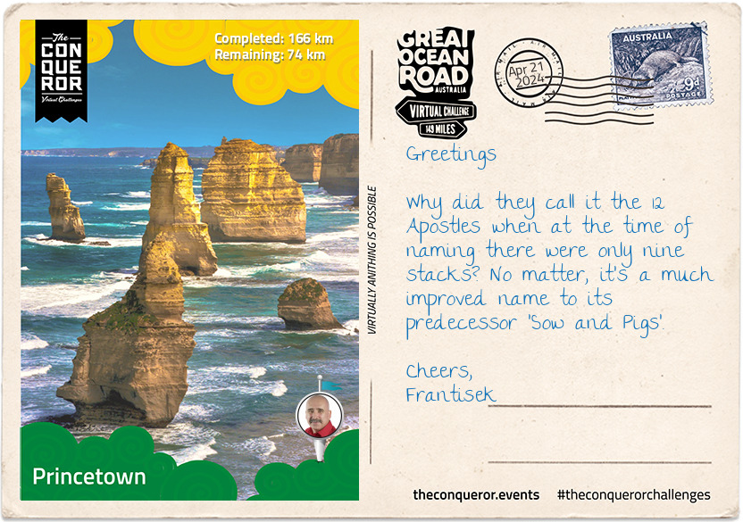
With much exuberance, I have arrived in Princetown. You might wonder why I am so excited. It is because anyone who thinks of the Great Ocean Road will no doubt have an image of the 12 Apostles. Of course, you need to travel about 105mi (170km) on the Great Ocean Road to get to it first, but the site of these magnificent limestone stacks never fails to impress.
The 12 Apostles is a collection of limestone stacks formed by erosion. Twenty million years ago, the stacks were once part of the mainland coast. Being made of soft limestone, the constant battering of the Southern Ocean slowly chipped away at the cliffs until caves were formed, which further eroded into arches leaving the rock above the hollow without support which then collapsed, creating the rock stacks.
It was originally named The Sow and the Piglets by British explorer George Bass when he came upon it in 1798. The name referenced the nearby Mutton Bird Island as the Sow and the stacks as her Piglets. At one point, it was also named The Pinnacles, however, in 1922, the stacks were renamed to 12 Apostles even though at the time, there were only nine stacks. The ninth and eighth stacks have since collapsed, leaving seven stacks about 148 ft (45m) tall.
The Southern Ocean is relentless though with its high salty forceful waves, and it is expected that over time these stacks will disappear but anticipate new ones to be formed. Unlikely that it'll occur in our lifetime, but the certainty is there that the cliffs of the Great Ocean Road are continuously evolving and changing.
Before I move on to the necessary shipwreck story, did you know about the Drowned Apostles? In 2016 a PhD student was analysing sonar data beneath the ocean 3.7mi (6km) away from the famous stacks when she came across five submerged limestone stacks jutting from the ocean floor. Surprisingly the submerged stacks are preserved and it is assumed that during the last ice age, the "sea levels rose so fast as the ice melted that the stacks were simply swamped in place". With the five submerged stacks and seven stacks above sea level, I guess there really are 12 Apostles.
Let's roll back the time to 22 May 1891 when the barque called Fiji, set sail from Hamburg, Germany with a crew of 26 for the Australian coast. Following a slow and trying voyage, in the early hours of 6 September, the Fiji sighted the Cape Otway lights and what seemed to be land looming ahead. Upon Captain's orders, the crew attempted to change the ship's course but a sudden shift in wind direction hampered the ship's correction and ran aground striking heavily onto rocks. Only two hundred yards from shore, the crew launched the rescue boats to no avail. The fierce surf that blocked the crew's access to the shore had swamped the boats and smashed them to pieces. It took several attempts, several hours and one drowning before a crewman was able to reach land and seek help. Several factors caused delays in rescue efforts increasing the crew's concerns about whether they would ever make it off the ship. They've been wrecked since 2am and dusk was already setting in. Eventually, a rocket line was launched from shore and fastened to the ship. Time was of the essence, and one by one, the crew hauled themselves along the rope hand over hand through the surf towards safety but not all would have the necessary strength to hold on and would disappear in the surf. The Captain was the last man off the ship and a mere 20 minutes later the Fiji broke and perished with only a piece of the bow washing ashore where it lays near the anchor of the Marie Gabrielle, wrecked on the same rock 22 years earlier. Now that I've given you a shipwreck story and an insight into the 12 Apostles, I'm off to the Sow and Piglets Brewery for a pint, where I'll pay homage to this phenomenal landmark.
km od začátku : 0188
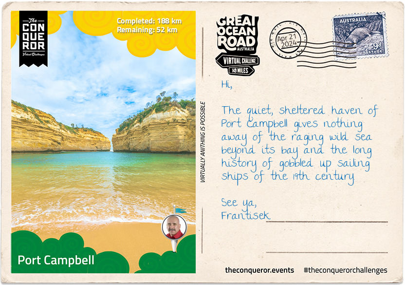
Port Campbell
Without a doubt, the 12 Apostles is the jewel of the Great Ocean Road but a short distance away before Port Campbell is the next famous spot, the Loch Ard Gorge, aptly named after the Loch Ard shipwreck in 1878.
The Loch Ard was a three-masted clipper built in 1873 and named after the Scottish lake "Loch Ard". The ship left for Australia in March 1878 with a cargo full of luxury items, a crew of 37 and 17 passengers. Reaching the Australian coastline after three months at sea, the Captain was expecting to see land and the Cape Otway lighthouse. Unfortunately, heavy fog reduced his visibility hampering his navigational fix and by the time it lifted in the early hours of the morning, the Captain realised that the ship was far too close to the coast. Attempting to steer the ship away from the coast, he ended up heading straight into the wind, at which point the sails went limp, and the bow turned towards the land. He then ordered for the anchors to be released, hoping it would hold its position, which it didn't when suddenly the bow was pulled around by the anchor. Dangerously close to the coast and the cliffs of Mutton Bird Island, the Captain tried again to turn the ship out to sea, but no amount of maneuvering would help. The ship struck the reef at the bottom of the Island. The top deck was loosened from the hull, and the masts and rigging came crashing down. The rescue lifeboat was launched but it crashed into the side of the ship and capsized, fifteen minutes later the ship sunk leaving only two survivors (Tom Pearce an apprentice and Eva Carmichael a passenger) and a 4.9ft (150cm) porcelain peacock model. Surprisingly the peacock survived intact and is currently on display along with other salvaged artifacts at the Flagstaff Maritime Museum in Warrnambool with an estimated value of AUD$4,000,000.
The gorge itself is accessible via a set of stairs, and to the right of the beach is the cave where Eva rested whilst Tom went for help. To the east and west of the gorge's cliffs are lookouts of Mutton Bird Island, which becomes home to some 12,000 mutton birds from September to April. Slightly to the west of the cliffs is a cemetery for those lost in the shipwreck and some of the prominent early European families who settled in the area.
A short walk away from the gorge is the Tom and Eva lookout with views of the Island Arch, which until its collapse in 2009, was once a limestone arch formation. Now they are two pillars that have fondly been named Tom and Eva.
Having my fill of Loch Ard Gorge, I'm off to Port Campbell for some good Aussie tucker. A serving of fish and chips with a stubby of Victoria Bitters, I think, is in order whilst I watch the sunset on the pier and contemplate my next stop at The Grotto and London Bridge and the final stretch to Allansford.
km od začátku : 0240
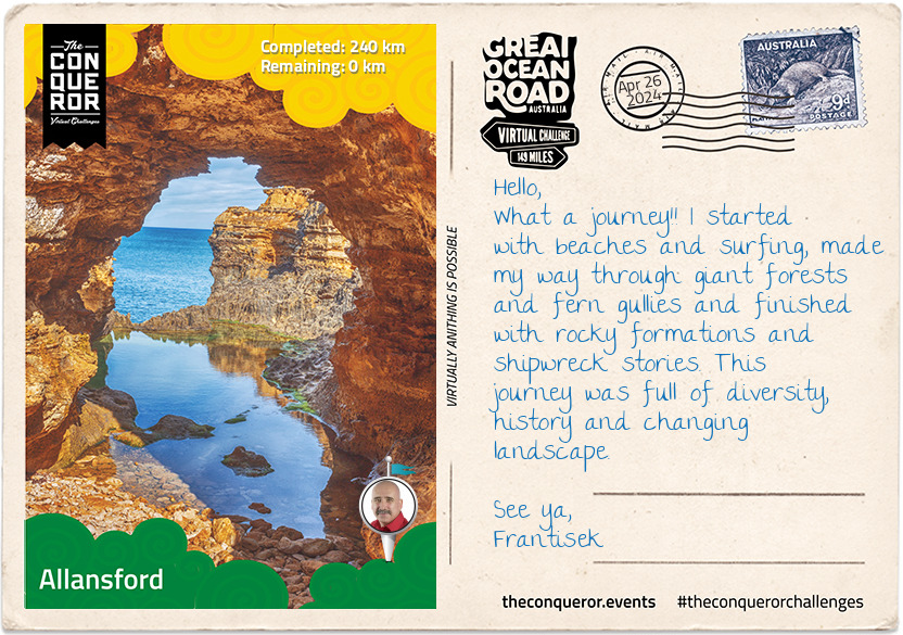
Allansford
Today was the final stretch of my Great Ocean Road journey, arriving in the small rural town of Allansford. Not a particularly well-known town except to maybe cheese fans. Main Australian cheese brands such Coon and Cracker Barrel are made at the Warrnambool Butter and Cheese Factory in Allansford. Registered in 1888, the Factory is the oldest dairy processor in Australia providing employment to 15% of the town's 700 residents.
Between Port Campbell and Allansford are three other iconic landmarks: The Arch, The Grotto and London Arch. The first one I explored was The Arch, and as the name suggests, it is an arch-shaped limestone formation resting atop a solid rock platform. It was a spectacular sight as the waves from the heavy swells washed over the rock platform from one side gliding through the opening and out the other side. From the viewing platform, looking into the distance, I could make out the 12 Apostles with the cliffs they were once connected to as a backdrop.
A short walk to the west of The Arch is another arch currently known as London Arch. Up until 1990, it was known as London Bridge when the formation was a double-span natural bridge connected to the cliffs and resembled the one in London. In January 1990, the span closest to the cliffs suddenly collapsed, stranding two people on the outer span. Fortunately, they weren't hurt and were eventually rescued by helicopter. Do you have this nursery rhyme playing in your head now?
"London Bridge is falling down, falling down, falling down London Bridge is falling down, my fair lady..."
Well, this bridge sure fell down. On that note, I moved on to The Grotto, a geological formation that is part blowhole, part archway and part cave. I took the steps down to The Grotto so I can look through the small arch across a rock pool onto the horizon and the sea beyond.
Several ships met their fate on the submerged reefs, but none had a more graceful demise than the Falls of Halladale. A beautiful four-masted iron-hulled barque, it was one of the last long-distance bulk carriers built. In 1908 the ship was on its way to Melbourne with a full cargo when in dense fog, the Captain miscalculated their position, and with full sails set, the ship struck a reef and took on water. The Captain and crew evacuated safely whilst the ship remained wedged firmly between two reefs with its sails billowing in the wind. Over several weeks the ship just foundered, a sight to behold to curious onlookers, slowly breaking up and slowly sinking. After two months, a salvage company blasted the ship and sunk it. It now lies 300m from shore in 10m of water, and it is part of a diving wreck trail. The recovered anchor is on display at the Flagstaff Maritime Museum.
Schomberg was another magnificent sailing ship with a 19th century Titanic-like story. A luxurious ship built at great expense, it was described as a perfect clipper that had the misfortune of sinking on its maiden voyage in 1855. The Schomberg sailed under the command of the highly reputed Captain "Bully" Forbes who was famous for holding the fastest sailing of 68 days from Liverpool to Melbourne. The Schomberg ran aground when the wind suddenly dropped, and the ship floated onto an uncharted sandbank getting stuck. Keeping the sails up, the Captain hoped he could force the clipper over the obstacle but to no avail. Luckily a nearby steamer saw the distress signal and changed course to help rescue the 430 passengers aboard. Over several days various ships helped with moving cargo and luggages until the clipper was no longer safe to be on. Unable to refloat the ship, it was left to break down, which took several years. At some point, the front portion of the vessel detached and floated off eventually washing up on the shores of New Zealand. Captain Forbes' reputation was in tatters as it came to light that he was below deck playing cards and delaying his presence at the helm. His stellar career never recovered, nor did he ever command another fast sailing clipper. Schomberg's bell is on display at the Flagstaff Maritime Museum, and the wreck is now a diving site. The ship may have sunk, but at least no lives were lost.
And this brings me to the end of the winding limestone coastline of the Great Ocean Road and the wild Southern Ocean. The Shipwreck Coast, with its shallow reefs and treacherous sea, has surprised and swallowed up many sailing ships leaving a trail of wrecks, lost lives, heroic rescues and cargo to plunder.
"I have seldom seen a more fearful section of coastline." - Explorer Cpt. Matthew Flinders regarding the Shipwreck Coast