The Great Wall of China (‘’the Wall”) is one of the most remarkable man-made structures in the world, with the longest building timeline. Beginning in the 7th century BC it continued on and off over several centuries until it peaked in the mid-17th century AD.
The Chinese were masters at building walls. First, they built them around their homes and cities as protection from their ferocious nomadic neighbours. Then, they built them to protect their borders from the wars that raged within their own nation. Most walls were of varying lengths and scattered throughout the land.
The Qin Dynasty squashed the various internal wars, unifying China in 221BC and established the First Empire. Shi Huangdi, the first Emperor and a ruthless ruler, used hundreds of thousands of people to connect and extend the existing walls for defence. By the end of this dynasty 3,000mi (4,800km) of wall ran along the northern border.
The Han Dynasty came next and building on the Wall ceased for a short period. Focus turned to peacetime and opening trade with the West. However, the nomads began raiding again, reprising the need for the Wall to be repaired and extended further. Safeguarding travelling traders became just as important as keeping the nomads out.
After the Han, the Wall was left neglected and crumbling. Vulnerable to attack, it was the sheer size of the Chinese army that kept most intruders at bay until Kublai Khan, a fierce Mongol warrior, forced his way into the capital and took the throne. With both sides of the Wall now Mongol territory, the Wall was no longer needed. Abandoned, much of the early construction disintegrated over time and very little now remains.
The Mongol rule was never accepted. A few decades after Kublai’s death, an uprising forced all the Mongols out and the Ming Dynasty (1368-1644AD) came into power. With the capital city in Beijing, it was much too close to the enemy border. A new wall was rebuilt from scratch. At time of completion, the Wall was 5,500mi (8,850km) long, built by millions of soldiers and forced labourers over a period of 200 years. It is the remnants of this Wall that continues to exist today.
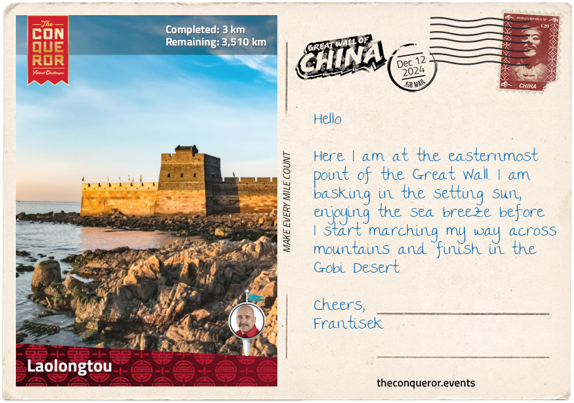
This journey of 2,183mi (3,513km) will begin at its most eastern end where the Wall meets the sea. Regarded as the start of the Great Wall, it is known as Laolongtou (Old Dragon’s Head) because the structure, consisting of a beacon tower and battlement walls, resembles a dragon drinking water from the sea.
The Wall twists and turns its way through the landscape, just like the legendary Chinese Dragon. It crosses mountains tightly straddling narrow cliffs, over lakes and sometimes under, into valleys and through deserts until it reaches the westernmost point ending in a remote outpost in Yangguan.
From the sea breeze on the wall of Laolongtou to the searing sun of the Gobi Desert, I hope to piece together the lengthy story of the Great Wall and the Emperors, Dynasties and Generals that left their mark on it.
Fast facts to give some sense of timeline and the main dynasties during the Wall’s construction:
5th to 3rd century BC – Warring States (Chinese states fighting amongst each other)
221 to 206 BC – Qin Dynasty (First Empire)
206 BC to 220 AD – Han Dynasty
386 to 577 AD – Northern and Southern Dynasties
1125 to 1234 AD – Jin Dynasty (conquered by Mongols)
1368 to 1644 AD – Ming Dynasty (Builders of currently existing wall)
km od začátku : 0012
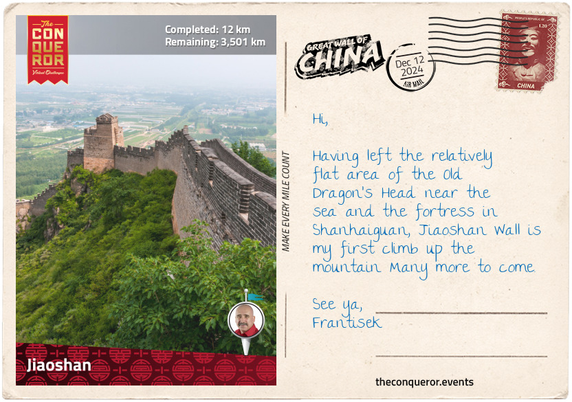
Jiaoshan
About 4mi (6.4km) from Old Dragon’s Head, in the centre of a large town, was the old fortress Shanhaiguan (Shanhai Pass). Built by General Xu Da in 1381, it was fortified and expanded by General Qi Jiguang in 1583 to seal off passage from the Manchu tribes in the northeast. It was the most important pass on the Wall.
Shanhaiguan did a fine job safeguarding the country until years of drought and famine gave rise to numerous peasant rebellions. At the same time, the Ming armies were busy defending the northern borders from the Manchu tribes. It all came to a head in 1644 when the city of Beijing fell at the hands of the rebels. Hoping to oust the rebels and restore order, a powerful Ming general sought assistance from the Manchu leader. Forming an alliance, the general surrendered Shanhaiguan, essentially throwing the doors open for the Manchu to enter. However, the Manchu had their own agenda, and once through the Pass they set about conquering Beijing and replacing the Ming Dynasty. The Qing Dynasty was born and it ruled for nearly 300 years until it was abolished in 1912.
The fortress, in a near-square shape, had a barbican on its east side. Arrow towers used to be at each gate but only one remains today. The walls were made of rammed earth covered with bricks. Views of Jiaoshan Wall to the north and the sea to the south can be seen from the top of the east tower.
Jiaoshan Wall was outside the city and it was named after the highest peak north of Shanhai Pass. Its translation is ‘Horn Peak’. This is the Great Wall’s first mountain climb. Built during the reign of the first Ming emperor (c. 14thC), Jiaoshan sealed the access between Shanhai Pass and the mountainous region of the China-Manchuria border.
Jiaoshan was built of locally quarried materials. A small section, less than a mile, has been restored with wide paths leading up the mountain to the unrestored section, where the path began to narrow. Some of the battlements along the Wall were built on only one side, with steep cliffs providing natural defence on the other. A few of the watchtowers were so high that metal ladders were installed to provide access.
Proceeding up the mountain, Jiaoshan ended at the Big Flat Summit on Dapingding Peak. Here I was afforded views of Jiaoshan Wall and Shanhaiguan to the south, Changshou Mountain to the north and the substantial Shihe Reservoir to the west.
km od začátku : 0028
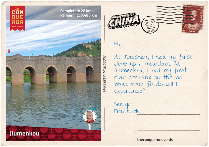
Jiumenkou
Descending from the mountains, I came across a bridge spanning a river. Made of granite stone, the bridge, at about 330ft (100m) in length, had eight shuttle-shaped piers and nine arches. It was aptly named ‘Nine-Arch Great Wall Bridge’.
Flanked between two mountains, the river was an important pass and an original wall was built here in the 5th century. The Ming rebuilt it 900 years later, fortifying the valley and naming it Jiumenkou Pass. Nicknamed the ‘Great Wall over Water’, Jiumenkou was quite unusual as it was the only section of the entire Great Wall that crossed a river. Usually, rivers were seen as natural defence barriers and as such the Wall stopped at the river bank and then started again on the other side.
The bridge provided military control over all the river-crossings and river transportation. It was solidly built with a granite stone foundation of 7,000sqm embedded on the riverbed. Access was via the arches that served as gates, whilst the top was used for defending against enemies. At either end of the bridge were forts that during wartime held prisoners in flooded cells (water prisons).
Nearby was a secret tunnel carved beneath the Wall. At just over half a mile long (1km), the tunnel had one entry and two exits. It was used to station troops, store food and weapons and sneak up on the enemy from the rear. It is estimated that as many as 1,000 soldiers could stay in the tunnels.
Following archaeological excavations in the 1990s, many artifacts including cannons, blue and white porcelain bowls and big jars have been uncovered giving historians and military experts insight into life on the Wall.
Crossing the bridge, I head into the hillside for a bird’s eye view of the rocky mountains, the flowing river and the formidable bridge that ties it all together.
km od začátku : 0109
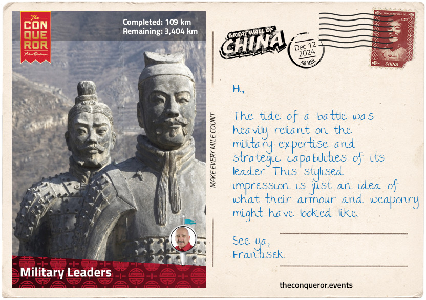
Military Leaders
Whilst Emperors dictated the building of the Great Wall, it was a handful of exceptional military leaders that made it happen. During the Ming Dynasty two names pop up again and again as the commanders in charge of the various constructions.
General Qi Jiguang – 16th century
Qi Jiguang was raised in a military family. He began his military career at 17 and was relieved of duty after 38 years of service. Spending most of his career fighting the Mongols in the north or the pirates in the east, Qi was instrumental in developing new combat tactics that helped defeat China's enemies. As such, he was put in charge of training the imperial guards and was promoted to the highest military rank of Commissioner-in-Chief.
During his time on the Wall, he undertook a massive expansion project, repairing and reinforcing the Wall’s defences, installing as many as 1,000 watchtowers over a 380mi (608km) stretch. These works helped fend off the northern enemies for more than a decade until the Ming Dynasty was replaced. Qi was also known for documenting his thoughts on military strategy into two books and wrote many poems and works of prose.
General Xu Da – 14th century
Young Xu Da grew up at the tail end of the Yuan Dynasty, led by the Mongol empire. Playing warlike games with Zhu Yuanzhang, he was unaware of the fate that awaited both of them in later years. Zhu became a prominent rebel leader with Xu serving as a general. In 1368, together, they led an attack on the capital city and forced the Yuan ruler out, becoming the founders of the newly formed Ming Dynasty, with Zhu as its first emperor and Xu as a general and later a politician. Xu’s first task in relation to the Great Wall was to build the Shanhai Pass near the sea, which he completed in less than two years. He went on to build many sections of the Wall that were reinforced two centuries later by Qi Jiguang. Xu remained in the emperor’s service for 32 years until his passing.
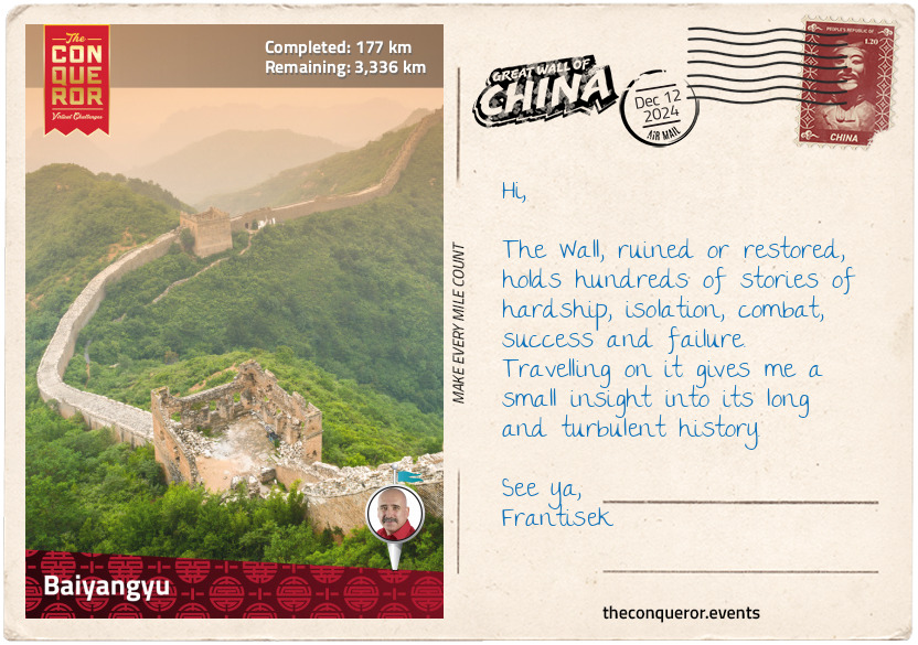
km od začátku : 0177
Baiyangyu
Travelling through several unrestored sections of the Wall, I arrived at Baiyangyu Wall, translated as ‘White Sheep Valley’. The Wall here was split between east and west, with a village at the centre of it in a valley. The village occupied the banks of Baiyang River.
A unique feature of Baiyangyu was the one mile (1.6km) long section that was built out of marble. It is somewhat unusual since most of the wall was constructed from rammed earth covered in bricks or occasionally quarried granite. With the average height of the Wall at around 20-30ft (6-7m), the marble wall here was quite tall at 33ft (10m) and was also a reasonable width at 16ft (5m).
Coming from the east, just before I descended into the village, I entered what is now referred to as ‘Wild City’. It was a wall-enclosed open space with a solid gatehouse at the western end. There is no record of what it was used for, leaving me with unanswered questions. Fortresses and watchtowers were built on the Wall to house troops and store grains and weapons. This could have been one purpose but it is very big in size. Is it possible that it stationed a cavalry unit as there’s plenty of space for horses as well as soldiers?
Interestingly, when I exit through the gate, I end up on a trail because there’s no connection to the Wall, which is located northwest of the gate. Of course, that raises more questions, such as, how did they get to the gate? The Wall itself is considered to have an outer wall (facing the enemy) and inner wall (friendly side). The gate to this city was on the friendly side so perhaps access was through mountainous terrain, straight up from the valley floor. What do you think?
Left pondering, I descended into the village, crossed the river on a regular bridge and started up the westside on an unrestored, but in reasonably good shape, section of the Wall.
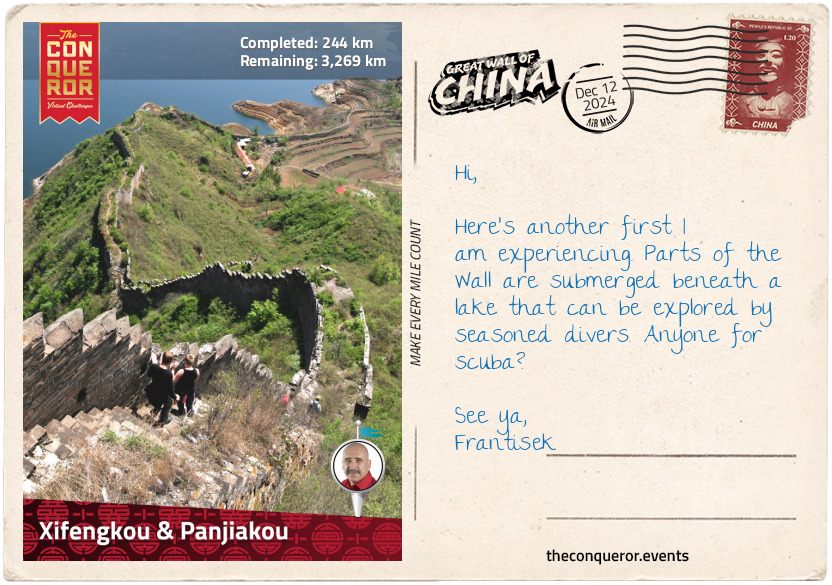
km od začátku : 0244
Xifengkou & Panjiakou
Now this is an exciting portion of the Wall. Two different walls near each other named Xifengkou and Panjiakou are part of the Underwater Great Wall.
When they were first built, both sections were strong fortresses between the mountains. The construction of both walls took place in different centuries with Xifengkou built in the late 14th century and Panjiakou in the mid-16th century.
Built by General Xu Da, Xifengkou was a major gateway to access central China. It had three gates linked by stone walls. Surrounded by mountains on three sides and a lake on the fourth, Xifengkou was very difficult to attack, although it still saw many battles due to its proximity to the northern borders.
Panjiakou on the other hand was flanked by mountains and had Luanhe River running through it. This wall was built by General Qi Jiguang, another military leader who successfully reinforced many sections of the Great Wall.
What made these two interesting was that both of them had parts of their walls underwater. When Panjiakou Reservoir was filled, it submerged the town of Panjiakou under 160ft (50m) of water, along with parts of Panjiakou Pass and Xifengkou Pass. A small part of Panjiakou Pass that was on higher ground is still above water. It is said that during low water levels, some of the underwater walls become more clearly visible.
One endearing description likened the area to a giant dragon crawling along the winding wall towards the lake. Diving in, it later re-emerges on the opposite side, climbs up the ridges and lies down to rest on the lofty mountains.
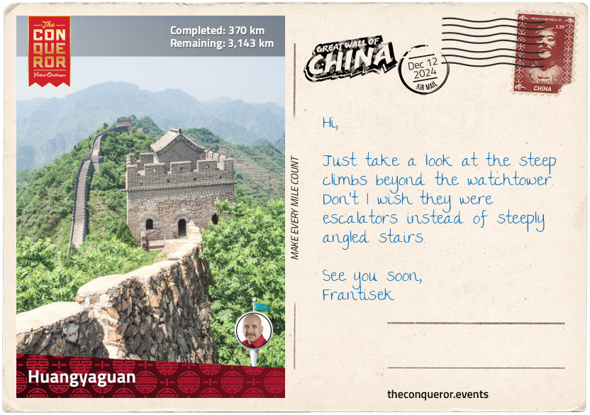
km od začátku : 0370
Huangyaguan
The original Huangyaguan Wall was a combination of a 6th century stone foundation and 16th century brick battlements. It stretched for approximately 26mi (42km), although other sources cite 34mi (54km), and had 66 towers and a fortress.
As the only Wall located in Tianjin, a major port city southeast of Beijing, it held a very strategic position. Enemies wanting to invade Tianjin had to go through the Huangyaguan Pass. Numerous battles occurred here that destroyed the wall.
In the 1980s, a 1.8mi (3km) stretch of the Huangyaguan Wall and the nearby Taipingzhai Wall were fully renovated, making it one of the longest restored sections of the Great Wall. It consists of a military fortress, a gatehouse and 20 watchtowers.
The Huangyaguan fortress is nestled in a valley between Banlagang Mountain to the east and Wangmaoding Mountain to the west. It is connected to Taipingzhai Wall to the east by a bridge. During wartime the five arches beneath the bridge were closed, blocking access via the river. On the bridge’s battlements, soldiers would set up cannons to fire at enemies approaching on the river.
Taipingzhai Wall is just over half a mile long and built on the mountain ridge. It begins at the bridge and ends at Banlagang Mountain where the steep, rocky terrain takes over as a natural barrier. Part way along the wall is a barbican used as an alternative entrance and near it is a 28ft (8.5m) tall statue of Qi Jiguang. The statue was built by the local people who wanted to honour the general’s contribution to defending the borders against the northern enemies.
At the western end of Taipingzhai Wall is a square stone tower known as Widow Tower. Measuring 43ft (13m) high, the two-storey building was donated by 12 women whose husbands died building the Great Wall.
Huangyaguan and Taipingzhai are perhaps a little too perfectly restored. The essence of the Wall’s history, the ability to touch and feel its original stones or bricks are lost here. What remains though are those insane 85-degree angle stairs and the steep climbs.
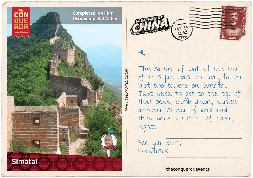
km od začátku : 0441
Simatai
Simatai Wall is the first of several closely located Great Wall sections north of Beijing. It has been partially restored but only as far as carrying out essential reinforcement work, preserving the original appearance and as such keeping the historic atmosphere. The Wall is divided by Simatai Reservoir and the two sides are connected by a suspension bridge about 530ft (150m) long. The west section used to lead to Jinshanling Wall but is no longer open due to its ruinous and dangerous state.
The restored section on the east side is accessed from the foot of the mountain, adjacent to the reservoir. The hike on the Wall is rugged and steep. There are 16 towers in all but only 10 of them are open to tourists. Although it seems to be more of a guideline than a rule, since some daredevils have conquered it. Let me illustrate the hike.
The trail begins at Tower 1 near the suspension bridge. Proceeding east, the trail passes through towers, up steep stairs and then back down. Between Towers 4 and 5 the wall is only on one side of the path with a chain safety-barrier on the other.
There is a fantastic view of west Simatai winding its way up the mountain from Tower 7 and a cable car terminal at Tower 8. The path flattens out a bit up to Tower 10.
The next two towers are not part of the restored section nor forbidden to hike but access is off the path, through brush and over some boulders. The official trail ends with a great big pink sign warning that a fine will be imposed if going beyond. But what does beyond look like?
From Tower 12 there is no more path. A few perpendicular walls lead to Towers 13 and 14 and after that there is just a single wall about 20in (50cm) wide, on an 80-degree gradient with plunging cliffs on one side and steep mountain on the other. The wall ends suddenly, leaving a gap between the wall and Tower 15. The only way around is by climbing off the wall onto a beaten path and circling around the tower to the other side.
Back on the wall, this part is known as Sky Bridge. Narrow and tiered, it is no more than 30ft (100m) long but a mere 16in (40cm) wide. Climbing the tiers, each one leads further up the mountain, until it opens up to a wide but ruined path. Good place to rest before the final arduous climb to Tower 16.
Wangjing Tower (#16) sits on the summit of Simatai Wall at an elevation of 3,200ft (980m). Anyone courageous enough to tackle the climb is afforded spectacular views of valleys, mountain ranges and miles of winding Great Wall.
km od začátku : 0455
Gubeikou
Gubeikou Wall is a dilapidated and unrestored part of the Great Wall. There are no parapets, no battlements and no paved paths. The wild vegetation envelopes the walls into the landscape and the towers are either in ruins or completely destroyed.
The first wall was built in the 6th century and lengthened 800 years later. Under General Qi Jiguang’s supervision the Wall was further renovated and enhanced adding more towers and passes. A second layer of bricks was added beside the first making this section uniquely double-layered.
As a key pass between China and Mongolia, Gubeikou’s Wall stretched for 25mi (40km) and it consisted of a staggering 186 towers, spaced at 650ft (200m) intervals. The defence system also included 19 passes, 6 fortresses and 3 barbicans.
Being the gateway to the capital, more than 130 battles were fought here during the dynastic periods. In the early 20th century, Gubeikou was once again embroiled in a fierce battle, except this time it was with the Japanese. In 1933, the Japanese attacked the Great Wall as part of their territorial expansion. Whilst territories and passes along the wall were being defeated, at Gubeikou Wall the Chinese were able to hold their position for several days by using the ramparts to move the soldiers along the Wall, just like their predecessors did centuries before.
Gubeikou Wall is made up of two sections, Wohushan to the west and Panlongshan to the east. Between the two sections, in a valley, is a lake and Gubeikou town beside it. At the edge of Wohushan, next to each other, are two well-preserved towers, named ‘Sister Towers’. Some say it reminds them of two sisters holding hands when viewed from a distance.
Past the village to the east is the entry to Panlongshan and its two watchtowers. The first one, General Tower, is a square shaped, two-storey building that was used as the commanding office. Now roofless, it has been exposed to the elements. The second one is the 24-window Tower, the last watchtower on this section. Three storeys high, the first two levels used to have three windows per side adding up to 24, hence the name, but two sides of the building have now collapsed leaving the other two heavily supported by steel poles.
Whilst the Wall continues on beyond 24-window Tower, it becomes a military zone and so inaccessible to travellers.
km od začátku : 0542
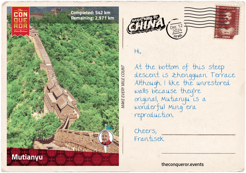
Mutianyu
Mutianyu Wall is fully-rebuilt and in complete contrast to Gubeikou’s wild and ruinous appearance. Constructed out of slabs of granite, as per the original Ming design, Mutianyu is approximately 1.8mi (3km) long and has 23 watchtowers spaced at 330ft (100m) intervals.
Mutianyu was first built during the 6th century but as with most of the Wall pre-Ming era, it no longer exists. During the early Ming period (14thC), the Wall was built a second time on the same site by General Xu Da.
Restored in 1986, Mutianyu is considered to be the best-preserved and the most scenic part of the Wall year-round. Located within Mutian Valley, with each passing season the Wall is a kaleidoscope of colour. In spring and summer, it is green and blossoming. In autumn it turns from crimson to amber to yellow. As the final leaves fall the white snow of winter ushers in.
Heading east to west, the first tower was at the junction of three paths. Known as Big Corner Tower, it is placed in such a way that only the corners are visible from any angle, hence its name.
After a couple of towers there is a steep descent that leads to Zhengguan Terrace. Made up of a large central tower flanked by two smaller ones, this type of build is a unique feature along the Wall. The three towers, connected by a 130ft (40m) long terrace, were used to store grains and station troops.
The path meanders up and down from here on a beautifully restored Wall. The earthy coloured bricks with softer, worn edges seem much more at home with the landscape than the sharp-edged, dark grey colours of Huangyaguan. It is interesting to observe the different approaches to restoration projects.
As the Wall snakes up and down the hills, I can’t help but liken it to a serpentine dragon lying across the mountains with the sawtooth path as the dragon’s scales.
km od začátku : 0547
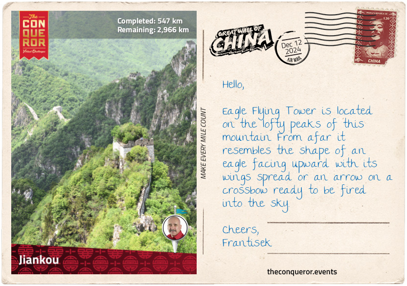
Jiankou
Where Mutianyu was beautifully restored, Jiankou is completely wild and ruined. Traversing steep ridges through dense vegetation, Jiankou is one of the most dangerous sections of the Wall. The bricks are broken, the walls collapsed and the path often vanishes before it reappears again. It is a wildly adventurous section, almost on par with Simatai.
The most exciting part of this Wall is the Eagle Flying Tower. Built on steep cliffs, the Wall has near vertical steps on both sides of the peak. On the left side the path requires scrambling up crumbled walls and endless sections of rubble. On the right side the descending stairs, known as Heavenly Ladder, lean at 85-degrees angle.
They are so narrow at the top that only one person could pass at a time. Each step is shallow horizontally and deep vertically, making it difficult to climb down. It would be easier getting down in a sitting position than standing up.
Several towers are engulfed by trees, their canopies peeking through the broken rooftops that once served as battlements. Once again I marvel at the structure and try to imagine the many workers that toiled in all kinds of weather conditions building this.
So much of Jiankou has been dilapidated that between 2015-2019 a huge repair project was undertaken. A half mile (750m) long section was faithfully restored, focusing on strengthening the walls, fixing broken bricks and clearing the dense thicket. A few trees that have grown through the bricks have been left there whilst others were removed to clear the path.
What raises my curiosity though are the two Mandarin signs that say “No Tourists” whilst at the same time there are signs dotted along the path directed at tourists. Another question is, why do the restoration if it’s not geared at tourism? The answers are elusive but there is no doubt that Jiankou is an explorer’s paradise.
km od začátku : 0575
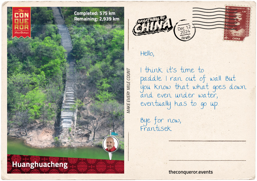
Huanghuacheng
Remember when the wall at Panjiakou was submerged beneath a dam? Huanghuacheng is another that was buried beneath the water.
When this Ming section was built, it took 188 years to complete. Towards the end of its construction time, scheming officials informed the emperor that General Cai Kai, who was in charge of the build at the time, was spending too much time and money on a sloppy job. The emperor, in his anger, ordered the general to be executed. It dawned on him later that perhaps he should have had the Wall inspected. Following a survey report, it was discovered that the Wall was actually very well built, solid, steep and fortified. Realising his mistake, the emperor ordered a monument to be erected in honour of the general.
Fast forward to modern times and Huanghuacheng is now divided by a reservoir to the west and a lake to the east. Several sections of the Wall are under water, of which two are accessed via dams. One of the submerged sections is not directly connected but a short path skirts around the water providing access to the other side. The third connection is over a glass-decked bridge.
The Wall between the reservoir and lake is in a ruinous state, with most of its sides completely destroyed, the watchtowers collapsed and trees growing through them. The original pavements are long gone and the trail is filled with wild vegetation, leaving only a narrow single-person track to hike through.
Huanghuacheng offers spectacular views of mountains, lakes and the ever-present snaking Wall ribboning over the ridges.
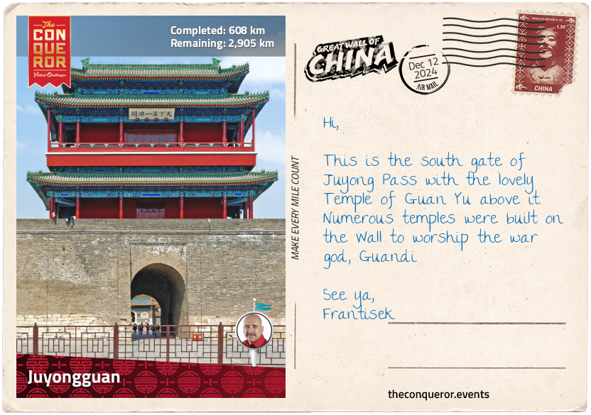
km od začátku : 0608
Juyongguan
Juyongguan, translated as Juyong Pass, was a solid stronghold and one of three very important passes. The other two were Shanhaiguan to the far east and Jiayuguan to the far west. Located in Guangou Valley it is flanked by Cuiping and Jingui Mountains.
The current structure is a modern renovation of the pass built by the Ming in the late 14th century with the earliest fortification dating to pre-Qin Dynasty (221BC).
In 1211, Mongol Emperor Genghis Khan breached the Juyong Pass not once but twice in his conquest of China.
Genghis Kahn was the founder of the Mongol Empire and a formidable military leader. During the Jin Dynasty (12th-13th centuries), on one of his campaigns, the Khan lured the Jin army to a field battle at Juyong Pass. Once outside the gates, the Khan’s soldiers retreated knowing full well the Jin soldiers would give chase and leave the Pass unattended. The Jin were swiftly surrounded as the greater Mongol army appeared from the nearby mountains. Deceived and defeated, the Pass was breached and ransacked.
Barely two years later, Juyong Pass was once again under attack by Genghis. This time, the Jin soldiers sealed the north gate but Genghis, not to be outdone, took an alternative route. He travelled over 120mi (190km) southwest to the next but less-guarded pass, crossed it and returned to Juyongguan, attacking it from the south gate and recapturing it.
Juyongguan is a circular route that can be tackled either from the north gate or the south gate. A total of 14 watchtowers are dotted along this 2mi (3.2km) stretch. The width of the wall varies from as little as 4ft (1.2m) to as wide as 55ft (17m).
The path heading west climbs about 2,000ft (600m) up Jingui Mountain to the highest tower. As a steep climb, it is sometimes exacerbated by the steps that can range anywhere between a few inches to 2ft (61cm) in height. The east side is gentler with great views of the fort, the high watchtowers over the two gates and the river pass.
Being close to Beijing, it is a highly trafficked destination putting a lot of strain on the Wall and its ongoing maintenance.
km od začátku : 0623
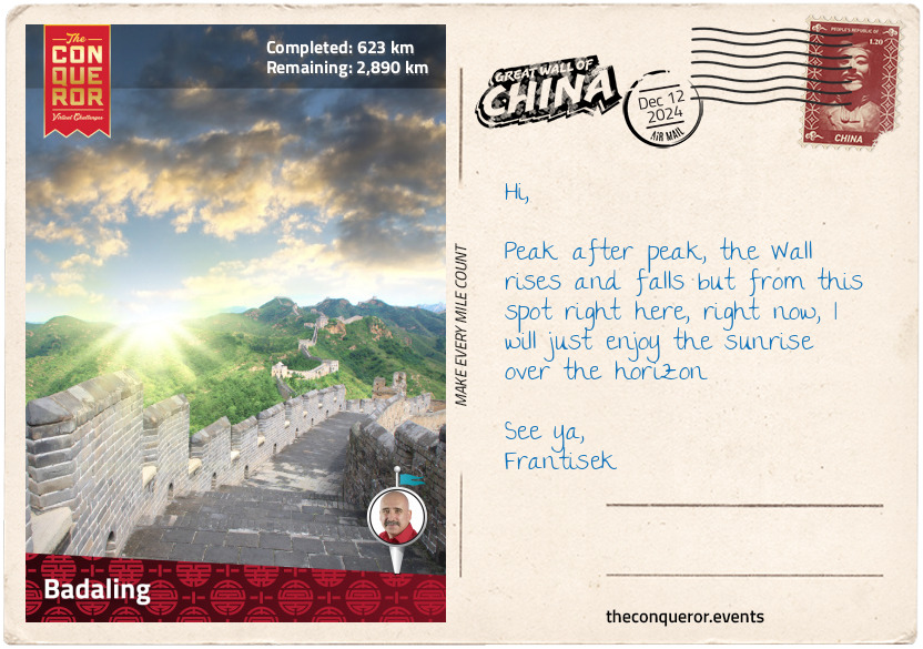
Badaling
First built in 1505 to protect the Juyong Pass, Badaling was fully restored in the 1950s and was the first section to open to tourism. Badaling is also the last major tourist centre and is where the Wall that most people know about ends.
Stretching across mountain ridges, the width of the Wall is 19ft (5.7m), intentionally built to accommodate five horsemen galloping across side by side or ten soldiers marching shoulder to shoulder. Split into north and south, Badaling has 30 watchtowers – eight south of the main gate and 12 north of it. Its highest point is at 3,300ft (1,500m) with grand panoramic views of lush landscape and rocky terrain. Boardwalks and railings have been installed as part of the renovations.
Close to Beijing, Badaling was a major defence border on the northern frontier. When Genghis Khan unified the Mongolian tribes and established his empire, he set his sights on China. Many military conquests north of the Wall ensued over the next sixty years until his grandson, Kublai Khan, ascended the throne as Mongol Emperor in 1260. Establishing the Yuan Dynasty a decade later, he set up his capital in modern-day Beijing. When in 1279, he conquered the Song Dynasty in southern China, Kublai reunified the country and became the first Mongol to rule all of China. The Yuan Dynasty ruled until 1368 when they were defeated by the rebel leader Zhou Yuanzhang, who founded the Ming Dynasty.
Famous merchant and explorer, Marco Polo, spent 17 years in Kublai Khan’s court. He learned the language and served as a messenger. He was promoted several times to government official positions, something that was unheard of before, when most of China was closed to foreigners. Kublai Khan encouraged foreign trade and many envoys travelled by sea to visit China. When Polo returned to Venice, it was a turbulent time and he found himself thrown in jail. It was in jail where he penned his book, ‘The Travels of Marco Polo’. For a long time, his book was seen more as fiction than fact but in recent times his accounts have been verified by academics and other explorers.
When Christopher Columbus set off across the Atlantic two hundred years later, he carried with him Marco Polo’s book. Fact or fiction, Marco Polo inspired generations of globetrotting adventurers.
km od začátku : 0805
Great Wall Construction
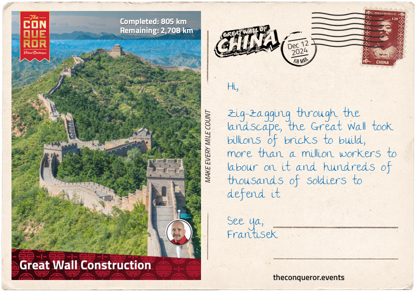
The Great Wall as we know it is a structure made of bricks and stones. It has forts and passes, watchtowers and beacon towers. All very well organised to create a complete defence system.
However, the construction materials used across the entirety of the Wall depended on the location’s climate, i.e. desert to the west, mountains to the east, and what was locally available to quarry. The main materials used were: earth, reeds, sand, wood, stones and bricks.
Workers would begin a section by building the towers first. They were made of wood and sun-dried mud bricks with sloping walls for stability. The rooftops were lookout and signalling stations. If enemies were spotted, fire was ignited in rooftop pits signalling the next tower to call for troops. Each tower then built a fire, becoming one long emergency call for assistance.
Outposts were built next on the enemy side of the Wall. These were forts occupied by garrisons who formed the first line of defence. They met the enemy first, before the rest of the Chinese armies arrived.
When the towers and outposts were complete, the workers built the connecting walls by first erecting a bamboo frame. Dirt was dug out from nearby and dropped into the frame, the workers would then ram the dirt until compact. The dirt was added in layers until it reached the top of the frame. When finished, the frame was moved down the line and the process started again.
Rubble was used to line the wall, stone lined the top and the road was paved. Battlements 6ft (1.8m) high had crenels and loopholes. Three storey watchtowers were built for surveillance and one to two storey beacon towers were for communications. Fortresses held the command posts and their gatehouses served as passes.
Where possible, they used mountains and rivers as natural barriers, saving labour and costs and on steep mountain slopes they only built a single thin wall.
These basic principles of building were used all the way through the Ming era. With material and technological advancement, the Ming just made the Wall bigger and better by covering the walls with bricks and stone and used sticky rice to strengthen and waterproof their mortar mix. Making it more attractive was the added bonus.
Fast Facts:
Average height: 20-23ft (6-7m)
Average width: 13-16ft (4-5m)
Highest elevation: 4,722ft (1,439m)
Lowest elevation: just above sea level
km od začátku : 0956
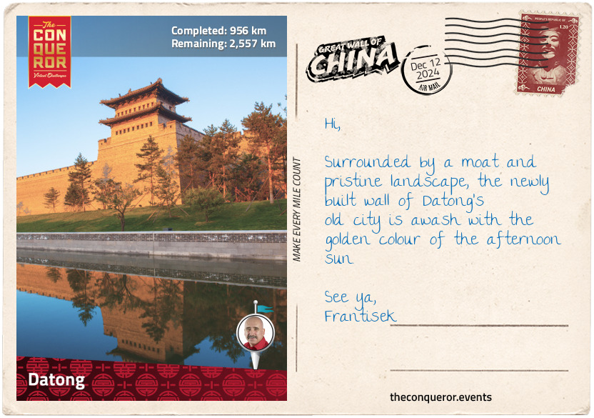
Datong
Datong has a long history, dating as far back as the 5th century BC when it served as a military fort during the Zhao Dynasty. When the Qin replaced the Zhao in 221 BC, the emperor ordered the Great Wall to be extended on its western border, north of Datong.
When the Han Dynasty replaced the Qin, Datong became the headquarters for its eastern frontier. Then the Northern Wei Dynasty replaced the Han and they set up the capital in Datong. The Wei walled the city in 421 AD, with an outer wall circumference of 10mi (16km), then proceeded to build palaces and official buildings on a grand scale. As devout Buddhists, they built many beautiful temples that continue to exist today. To settle the new city, many Chinese families were forcibly moved from their home towns in the north.
The Wei also built the massive Yungang Grottoes, a collection of caves containing over 50,000 Buddha carvings. The caves are packed with statues of varying sizes, with the smallest barely 1.5in (4cm) tall. Other caves are brightly painted in rich colours of red, yellow, green and blue. A handful of large scale, intricately detailed Buddha sculptures can be found inside and outside the caves, with some measuring up to 23ft (7m) in height. In 2001 the caves were designated a UNESCO site.
The Hanging Monastery, located 40mi (64km) northwest of the city, is a stunning piece of engineering. It was built into a cliff 246ft (75m) above the ground by a monk about 1,500 years ago. The structure is resting on oak cross beams that are fitted into holes carved in the cliffs. This is one of a few temples that combines the three Chinese philosophies: Buddhism, Taoism and Confucianism.
Fast forward to the 21st century and the city walls of Datong have been fully rebuilt, complete with watchtowers, drawbridges and a moat. Inside is a combination of 6-storey apartment blocks and old courtyard homes. Temples, monasteries and palaces are mixed in with shops and restaurants. The highlight is the surviving 14th century screen wall named Nine-Dragon-Wall. It is 147ft (45m) long and 26ft (8m) tall with reliefs depicting nine different dragons. The wall was originally in front of a palace, designed to protect homes from evil spirits and negative energy. Ironically, the screen continues to exist but the palace is long gone.
km od začátku : 1127
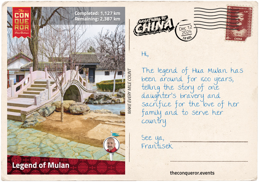
Legend of Mulan
Most people would be familiar with Disney’s animated film and live-action adaptation of the story of Mulan. Set during the Han Dynasty, Mulan’s father is conscripted to join the imperial army. Unbeknownst to her frail father, Mulan takes his place by impersonating a man and together with General Shang, she battles the Hun invasion.
However, the fictional Mulan is based on the Chinese legend of Hua Mulan from the Northern Wei Dynasty (4th-6th century AD). In the folk story, known as the Ballad of Mulan, dressed as a man, Mulan takes her father’s place in the imperial army and spends the next decade as a cavalry soldier, never revealing her gender.
In real life, a war took place between the Wei and a Mongol state called Rouran that, according to the ballad, lasted 12 years. The wars took place between Black Mountain, Wei State and Mount Yanran, Rouran, with Shahukou Pass, a Great Wall fortification at the centre of it. In the ballad, Mulan set off for Yellow River, then headed north towards Black Mountain when she hears the northern enemy’s horses neighing fiercely.
Mulan describes how after many years at war and many generals lost, only the brave warriors return home. As gratitude, the emperor bestows the warriors with gifts and titles, and he offers Mulan a ministerial position of the highest order.
Mulan, however, rejects the offer and retires to her hometown. Before she leaves court, she changes into women’s clothing, thereby revealing her gender, much to the surprise of her comrades.
The story is quite short but it has become a popular tale encouraging and inspiring young girls to be brave.
km od začátku : 1263
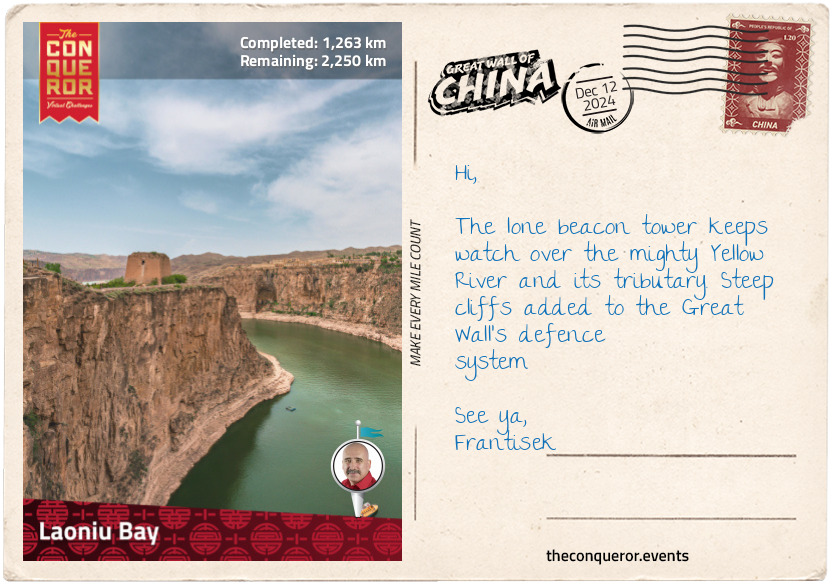
Laoniu Bay
Laoniu Bay sits at the junction of Shanxi Province to the south and Inner Mongolia to the north. It is where the Great Wall meets the mighty Yellow River and then runs alongside it for the next 44mi (70km). A lone, ruined beacon tower stands at the end of the headland.
The Yellow River has an amazing journey across China. Its source is in the Bayan Har Mountains, Western China at an elevation of 15,700ft (4,800m) and it flows east until it empties in the Bohai Sea. It is the second longest river in China, after the Yanghtze, and the sixth longest in the world.
Heading east, the river runs through two large freshwater lakes, Gyaring and Ngoring. The water is crystal clear with a steady flow. It then makes two loops, first is northwest, followed by northeast, before it takes a sharp southern turn until it turns east again for its final flow into the sea.
The upper river travels through pastures, swamps, knolls and peat bog. The terrain along its banks changes from steep cliffs to deserts and grasslands. When it reaches the middle section, the river runs through the Loess Plateau, where large amounts of mud and sand end up in the river, giving it the muddy-yellow colour. Each year approximately 1.4 billion tonnes of silt are carried to the sea. In 1933, a record 3.9 billion tonnes of silt were discharged into the river from the plateau. The flow here is powerful, making it a great location for hydroelectric plants. When it reaches the lower section, the river slows down and sometimes it even dries up before reaching the sea.
The Yellow River has flooded many times, causing enormous losses of life and destruction. It has also been used as a military tactic by sabotaging canals and reservoirs or intentionally flooding warring states. Sometimes such plans backfire, as it did in 1642, when a Ming governor ordered the dikes to be broken in the hope that it would flood the rebels. Instead, it destroyed his city, causing famine and a plague that killed nearly 80% of its population.
Over the course of the last 2,500 years, it is estimated that the Yellow River has flooded nearly 1,600 times. It has also changed its course noticeably 26 times and severely at least 9 times. The most significant change was in the 12th century when instead of flowing into the Bohai Sea, as it usually does, it shifted so far south that it flowed into the Yellow Sea. It took 700 years for the Yellow River to return to its more northerly course.
km od začátku : 1432
Chinese Dragon
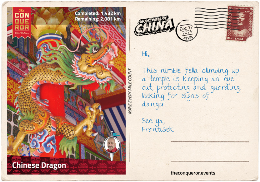
Remember Laolongtou, Old Dragon Head, at the beginning of this journey? He was drinking from the sea whilst the rest of his serpentine body, aka the Great Wall, contoured over the lofty mountain peaks and across valleys in a constant up and down motion. I am still searching for the tail.
The Chinese dragon is a legendary creature that is often associated with wealth, power and leadership. They are seen as noble and wise, exuding a good dose of luck and are often depicted breathing clouds instead of fire. It has control over watery phenomenon and is usually pictured floating in the sky, chasing flaming pearls, a treasured possession, that are said to multiply or enlarge anything that they come into contact with.
For a time during ancient China, only emperors were permitted to have items with dragon images on them. The dragon robe was an everyday garment used by royalty since the 7th century. It was a circular-collared robe embellished with dragons to symbolize imperial power. Over time, the cuts of the robes were modified to suit the ruling dynasty but the embroidered dragons were ever-present.
Chinese dragons are usually illustrated as having long, snake-like bodies and sharp, hawk-like claws. However, they can at times be rendered as other shapes such as dragon turtles. With the body of a turtle and the head of a dragon, the creature is typically associated with feng shui, symbolizing courage, longevity, success and more.
Dating back to 206BC, the Dragon Dance is the highlight of many festivities, especially Chinese New Year and the Lantern Festival. The dragon, up to 230ft (70m) long, is made of bamboo hoops covered with fabric and held by dancers. The dragon is moved in all directions, dancing to the sound of pounding drums. They are wonderfully colourful spectacles.
The Dragon Boat Festival is another important event that has the status of being included in the UNESCO Intangible Cultural Heritage list. The event commemorates the ancient poet, Qu Yuan, who drowned himself as a “gesture of dying along with his motherland” when his home state was invaded. The boat is shaped in the form of a Chinese dragon and the team paddles harmoniously to the sound of beating drums. The winning team is said to have good luck and a happy life in the following year.
Chinese dragons permeate everywhere, from architecture to textiles, artwork to ceramics, metalwork, jewellery, festivals, astrology and idioms. China is home to the most places named after dragons in the world.
km od začátku : 1609
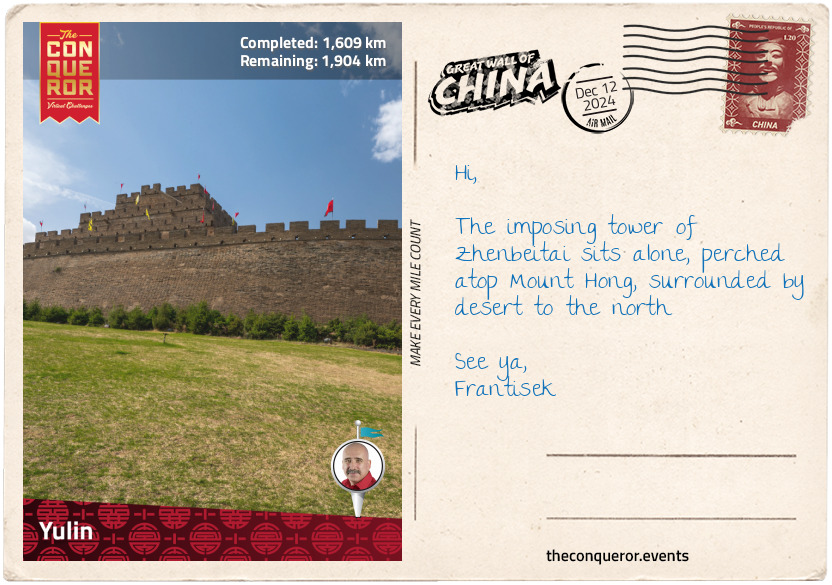
Yulin
In ancient times, Yulin used to be the northernmost border of China. Various walls were built throughout the centuries with the earliest dating to the 5th century BC right up to the 15th century AD, covering the rule of several dynasties. Some preserved walls and forts can still be found in Yulin and nearby cities but the most significant is Zhenbeitai Tower, the largest watchtower on the Great Wall.
Located about 3mi (5km) north of Yulin, the tower is affectionately referred to as the heart of the dragon, with its head in Laolongtou (far east) and its tail in Jiayuguan (far west).
Built in 1607 during the Ming Dynasty, its purpose was to protect the markets where Mongolians and local people could trade in peace. It was an important marketplace because highly prized Mongolian horses were traded along with cloth, silk, tea and salt.
The watchtower is connected to the southwest corner of the wall. Tapering towards the top, the tower rises across four levels to a height of 98ft (30m) and average base width of 230ft (70m). Each level is narrower than the one below. The surrounding wall is around 550ft (167m) wide with the northwest corner linked to remnants of the Great Wall. Made of rammed earth, it is dressed in bricks and stone.
From the top floor to the north is the Yellow River, flowing through the large Hongshixia Reservoir, heading south for hundreds of miles.
Within the surrounding walls was Kuangong City, where officials used to entertain Mongolian messengers and discuss foreign affairs. During peacetime, Mongolians showered the emperors with gifts such as livestock and in return they would receive silk, cloth and medicine. It was a prosperous city in the past but very little is left today.
km od začátku : 2021
Yinchuan
Yinchuan was the capital of the 11th century Xixia state (modern-day Ningxia) and was occupied by the Western Xia Dynasty. The people of Western Xia were originally Tibetan and when the capital was established as part of the empire, the native Chinese were so dissatisfied that the entire population emigrated.
The city experienced a terrible blow when the Mongols, under the leadership of Genghis Khan, laid siege to it in 1227AD. Yinchuan was under siege for six months when Genghis suddenly died. To keep the campaign on track, his death was kept a secret. A month later, the emperor surrendered and was immediately executed. Genghis’ policy was always to conquer and eradicate those who resisted him. As such, the entire population of Yinchuan was slaughtered and the Western Xia Dynasty fell.
The few royal members that survived retreated either to Tibet or the far east. Very little is known about this dynasty, since the Mongols pillaged and plundered the capital, leaving very little evidence of its existence behind.
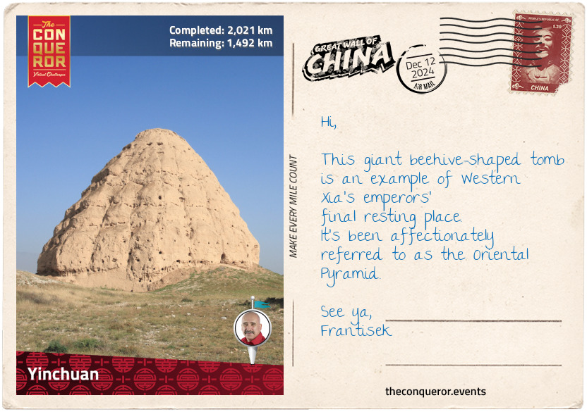
About 25mi (40km) west of Yinchuan are the Western Xia Imperial Tombs. Located at the foot of the Helan Mountains, the burial complex was only discovered in 1972. Special liquid was sprayed on the excavated relics to protect them from exposure. So far nine imperial mausoleums and 250 minor tombs have been discovered. They have a unique beehive shape and are often referred to as the Oriental Pyramids.
The largest and most complete tomb is said to belong to Jingzong, the first emperor of the Western Xia Dynasty. The large tomb is 75ft (23m) high and it is believed to have once been a 5-7 storied, eight-sided pagoda. Combining mausoleum and temple styles, it was built in accordance with Buddhist architecture.
Large amounts of inscribed stele fragments were found in the complex, giving scholars a rare opportunity to learn a little more about the vanished Xixia civilisation.
km od začátku : 2216
Zhongwei
Zhongwei is a small city located on the northern bank of the Yellow River. North of the city and on the edge of Tengger Desert are remnants of the Great Wall. It was built during the Qin Dynasty (210 BC – 259 AD), when China was unified for the first time and served as a minor pass during the Ming era.
The walls were built out of earth and stone only, unlike the sections to the far east that were reinforced and covered in bricks. This led to extensive erosion of the Zhongwei Wall that was impacted further by the Tengger Desert’s ongoing expansion. The shifting sand has swallowed many towers as the desert continues to move south towards the city of Zhongwei. Some parts of the Wall have been erased completely with the growth of local industrialisation.
Just to the northwest of Zhongwei Airport’s runway is a very large, solid, mud-brick tower with a wall enclosure that was possibly either a fort or a fortified gate of the Wall’s pass. The line of the wall vanishes here to only appear sporadically for the next 150mi (240km).
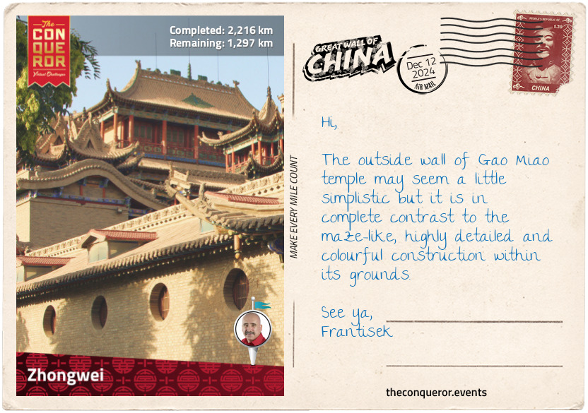
The main landmark in the city is the maze-like structure of Gao Miao Temple, where China’s three main religions - Confucianism, Taoism and Buddhism - are combined into one. The temple has a staggering number of pavilions, up to 260, that are connected with bridges, leading up and down between levels. It is beautifully decorated in bright colours with Chinese dragons on its rooftops, bells hanging off the eaves and more than hundred religious sculptures inside.
The quirky attraction at Gao Miao is actually the underground display of statues, suffering different forms of punishment and torture, meted out based on the crime committed. These strange and gruesome scenes are meant to depict life in hell based on ancient Chinese legends.
This may seem like a unique or unusual ‘attraction’ but it is not dissimilar to the ‘Ten Gates of Hell’ on display in Haw Par Villa, Singapore.
It is certainly not for the faint of heart or for the young.
km od začátku : 2382
Terracotta Warriors
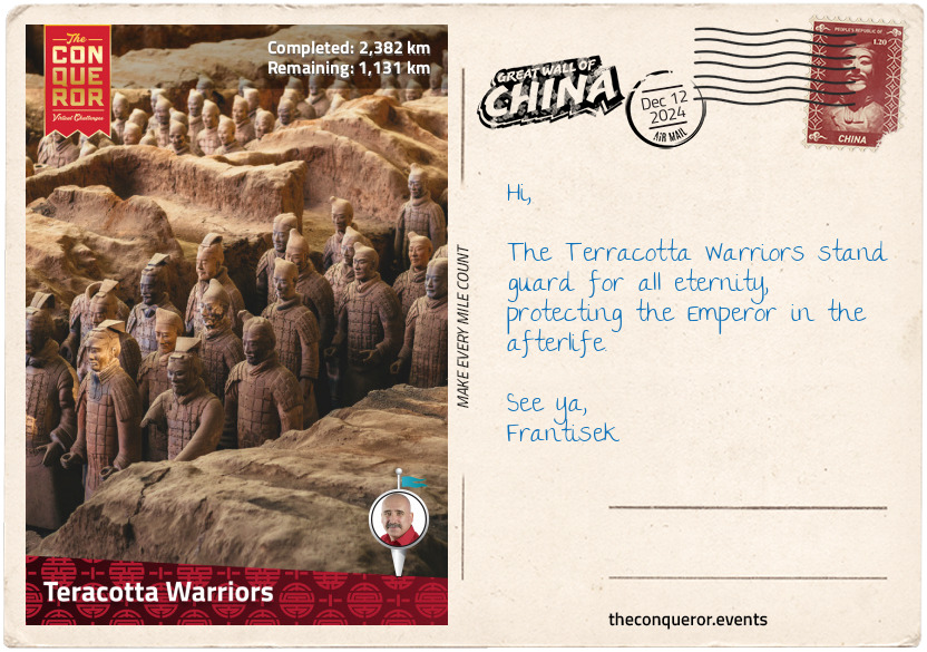
The amazing discovery of the world-renowned Terracotta Warriors was the accidental work of a small group of farmers digging a well. Imagine their surprise when, instead of finding water, they dug up a head made of terracotta.
It was 1974 and the archaeologists were in for a treat. The more they peeled back the covers, the more they needed to keep going. Hundreds upon hundreds of soldiers, horses, chariots, armour and weaponry were being revealed.
Four main pits were unearthed, with Pit 1 being the largest. At 750ft (230m) long and 203ft (62m) wide, the pit contains 6,000 warriors, 200 horses and 50 chariots. The warriors are life-sized, between 5.74-6.6ft (175-200cm) tall and weigh several hundred pounds each. Pit 2, although smaller, has 850 warriors, 116 cavalry and 89 chariots each drawn by four horses. Although debated, it is thought that these two pits may represent the imperial palace guards. Pit 3 is the smallest, containing a single chariot drawn by four horses and 68 warriors. This one is thought to be the command centre. Pit 4 is empty, perhaps an unfinished project.
Sculpted from terracotta, each figure was moulded by artisans into separate body parts and then assembled into a complete statue. Wet clay was then applied to create individual details. Standing according to rank, they feature different uniforms, distinct hairstyles, individual facial features, even their ears are unique.
All the figures were once fabulously painted in striking colours of red, pink, green, blue, black and white but unfortunately their exposure to air caused the colour to dry and flake. Fortunately, new techniques have been developed to successfully preserve the colours on new excavations.
The creation of the Terracotta Army was ordered by the First Emperor of the Qin Dynasty, Qin Shi Huang (3rd century BC). Supposedly a workforce of more than 700,000 people was used to construct enormous tombs filled with treasures and an army to protect him in the afterlife.
His massive mausoleum, less than a mile (1.5km) away from the pits, remains sealed. There are concerns that an excavation may damage the emperor’s corpse and artifacts in the tomb, a greater concern are the rivers of liquid mercury that have been detected inside the tomb. The emperor was obsessed with immortality and believed that mercury was the elixir of life. In his quest for eternal life, he ingested mercury pills regularly. Instead of making him live forever, it most likely contributed to his death.
km od začátku : 2575
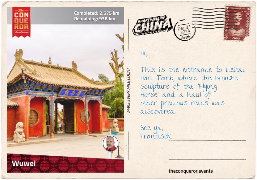
Wuwei
In ancient times, Wuwei was an important town along the Hexi Corridor, a significant trading route that connected central China to the western regions. This 620mi (1000km) passage was linked by Wuwei, as its eastern terminus, to Yumen Pass, in the west. The Corridor, an arable plain, was long and narrow, sandwiched between the inhospitable plateaus of Mongolia to the north and Tibet to the south. It became a hub for the ancient silk road.
During the 2nd century BC, the Hexi region was reigned by the Xiongnu, a nomadic tribe, until a Han General, on the orders of his emperor, conquered the tribe and took over the corridor. As a result, Wuwei became a provincial capital of the Han Dynasty. Driving the Xiongnu out allowed the emperor to expand the corridor westward and protect the goods traded along the Silk Road.
In 1969, a group of farmers, digging air-raid shelters underground, unearthed a Han tomb belonging to an army general. Within, they discovered more than 200 relics consisting of wares made of precious metals, potteries, ceremonial figurines and a horse sculpture made of bronze known as the ‘Flying Horse of Gansu’.
The sculpture is an incredibly valuable piece, so much so that it is listed as one of 64 cultural relics prohibited from ever being exhibited outside of China. The horse is meant to depict the Ferghana breed (from modern-day Uzbekistan), that was highly prized by the Han emperor for its speed, hardiness and endurance. He went on to name the breed ‘heavenly horses’, after he was told that divine horses would appear from the northwest. The artwork itself is brilliant as the horse, in a galloping state, is balanced by one hoof resting without pressure on a flying swallow. The sculpture became a symbol of Wuwei City and it is used as a logo for China Tourism.
km od začátku : 2832
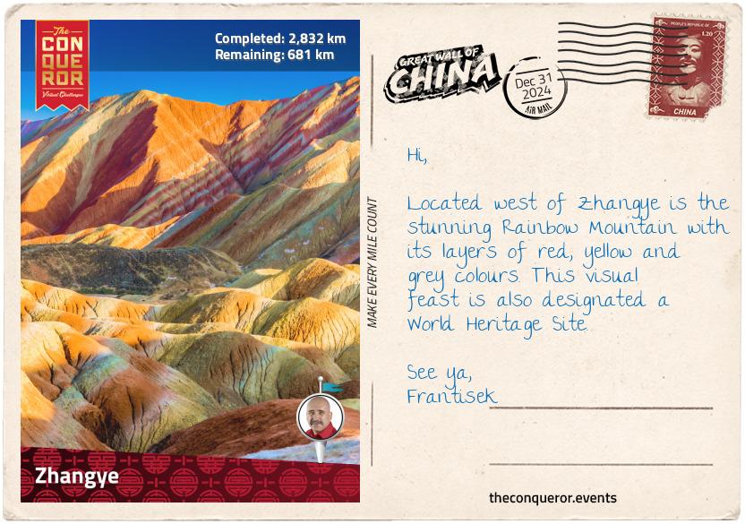
Zhangye
Zhangye is a city that sits in the centre of the Hexi Corridor and was an important outpost on the Silk Road. It was also a border town, protecting inner China from the nomads in the northwest. Across centuries, dynasties and nomadic tribes engaged in warfare in the area, such as the Han against the Xiongnu, Western Xia conquering the Uyghur Kingdom or the Mongols exterminating Western Xia.
In the city centre is the Great Buddha Temple. It was built in the 12th century during the Western Xia era when they controlled the Hexi Corridor and it is largely known for its massive reclining Buddha, stretching 115ft (35m) in length. It was rumoured that Kublai Khan, Mongol emperor of the Yuan Dynasty, was born in the temple and that the last emperor of the Song Dynasty was exiled here and became a monk. However, no evidence to corroborate either story has been found.
Southeast of the city centre is Shandan County, home to several remains of the Great Wall. Although many sections have crumbled, were mowed down, got hollowed out or even had a highway cut through, the Shandan Wall is still a fine example of rammed earth construction. Two walls, from two dynasties exist beside each other, at distances between 33-262ft (10-80m). They are both built from rammed earth at least 1,500 years apart.
The earliest, from the Han era, was built in 111 BC. Most of it has eroded or been looted, with only round mounds that were once watchtowers remaining. They are dotted alongside the sturdier and better-preserved Ming wall. A study of the two walls reveal the evolution of construction methods and the advancement of techniques and materials.
Being located on the edge of the Gobi Desert, both walls are at risk of ongoing damage or erosion, either from ongoing human interference or the harsh desert climate.
km od začátku : 3082
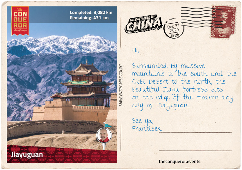
Jiayuguan
Further into the desert and at the narrowest point of the Hexi Corridor is Jiayu Pass, the first fortress at the western end of the Ming Wall. Together with Shanhai Pass near the sea and Juyong Pass near Badaling, they are the most important passes along the Great Wall.
Construction on Jiayu began in 1372 AD by General Feng Sheng, at the onset of the Ming Dynasty. It was completed 168 years later in 1540AD. The trapezoid-shaped fort has a perimeter of 2,405ft (733m) and a height of 36ft (11m). It is a complete defensive system consisting of an inner and outer city, beacon towers, corner turrets, watchtowers, barbicans and pass gates. In front of the fortress is a spring that forms an oasis, which was one of the reasons for building here.
Being in the desert, the structure of the fort is different to the brick and stone walls in the far east. The desert soil, known as loess, is rich in calcium carbonate and when mixed with water has self-cementing properties. To build the wall, the soil was tamped together in 5.5in (14cm) layers and between each layer was a spread of dried reeds that provided a drainage mechanism for the rain. This combination and the method of building made the walls tremendously strong.
South of the fortress is the ruin of the Great Wall’s first western beacon tower. When it was first built in 1539 AD, it stood 46ft (14m) high but now it is a pile of dirt, less than half the height. Although not much is left of this important outpost, it remains a marker of the Ming Wall’s western beginning.
There is a legend told of an official in charge of building the fort asking the designer how many bricks would be needed for the construction. The designer promptly answered 99,999. When the official queried if that was enough, the designer added one more brick. When the fort was finished, there was one brick left over, which was placed loosely on one of the gates where it remains today.
About 5mi (8km) north of Jiayu Pass is the Overhanging Great Wall, a 750m long, fully restored wall, snaking up the hillside to a beacon tower. When it was built in 1540 AD, the wall was twice as long. Reminiscent of the various zig-zagging sections north of Beijing, the glaring difference is the terrain. Where in the east the landscape was verdant and much steeper, here in the desert it is barren and desolate. Even the earthy-coloured stairs leading up the mountain blend into the environment.
km od začátku : 3209
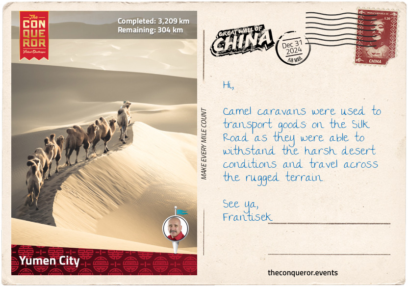
Yumen City
Located west of the Hexi Corridor on the edge of Gobi Desert is the small city of Yumen. Today it is an industrial city, primarily focused on oil drilling, wind power-generation and large-scale factories. However, 2,100 years ago, when it came under Han Dynasty control, it was a thoroughfare for merchants, warriors, diplomats and missionaries to trade goods and exchange knowledge, technology and religious beliefs.
This ancient trade route, along with several others, made up the renowned Silk Road. This overland route began in the city of Xi’an, then travelled along the northwest section of the Great Wall, over the Pamir Mountains, through Afghanistan and to the Mediterranean Sea where the goods were shipped to Europe.
At 4,000mi (6,400km) in length, the Silk Road was a melting pot of cultures and ethnic diversity. Very few people travelled it in its entirety, giving rise to a number of middlemen and trading posts along the way. Bandits were a major threat to travellers. To protect themselves, they would often join together in caravans and over time, inns to accommodate them cropped up.
Silk was one of the major goods exported by China to the west, hence the name Silk Road. Production of silk was a closely guarded secret in China and the fabric was highly prized by the Roman elite. Being of high value but low weight, silk was an ideal product to carry on long distances. Other significant items used for trade were: horses, jade, paper, spices, glassware, furs and unfortunately also slaves.
Marco Polo was one of the first Europeans to travel to China via the Silk Road. He was 17 years old when he embarked on a journey with his father to the far east. Leaving Italy by ship, they sailed to Acre, in modern-day Israel and then travelled by camel to Persia (present-day Iran) where they planned to sail straight into China. The ships, however, were not seaworthy and so they decided to continue overland through the Silk Road. During their trip, the Polos joined a travelling caravan that was soon ambushed by bandits who used a sandstorm as cover. They were fortunate to escape through a nearby town but sadly many of the caravan members were killed or enslaved. It took the Polos three years to reach Kublai Khan’s summer palace in Shangdu, China.
Trade on the Silk Road came to an end in the 15th century when transportation shifted to the sea, this became known as the Maritime Silk Road. The ability to carry more goods at a cheaper price marked the decline of the overland route.
The Silk Road could be seen as an early example of globalisation. It connected the Orient to Europe through trade and cultural exchange and at its end it inspired Europeans to cross the ocean and explore the New World (the Americas).
km od začátku : 3452
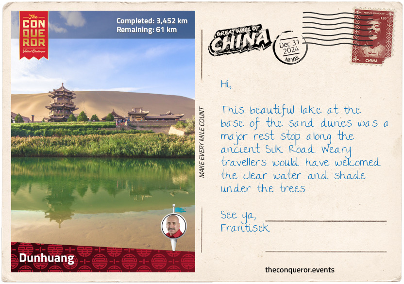
Dunhuang
The town of Dunhuang is situated in an oasis at the west end of the Hexi Corridor and the start of the Southern Silk Route. On the edge of the city is a crescent-shaped lake called Yueyaquan (aka Crescent Moon Lake) and the Singing Sand Dunes, that emit melodic sounds when the wind blows.
Originally occupied by nomadic tribes, Han Emperor Wu dispatched his military troops to expel them and by 121BC Dunhuang was brought under Han control. The emperor promptly ordered a Great Wall built, which stretched 85mi (136km) in length and consisted of 80 beacon towers. The structure of the wall was a combination of local sand and reeds, compacted together in layers.
Dunhuang, along with Jiuquan, Zhangye and Wuwei, was a frontier garrison town and played an important military role in the safety of both the region and inner China.
It benefited greatly from the Silk Road. As the intersecting city for the three main silk routes, Dunhuang was a key base for water and food supplies and a welcome sight for arriving travellers. The town prospered from the heavy traffic flow until it was plundered and destroyed by the invading Mongols. The town was rebuilt and subsequently brought under the Yuan Dynasty (Mongol Empire).
By the Ming Dynasty, Dunhuang went into decline, as the Silk Road was replaced by the Maritime Silk Route.
South of the city are the sandstone Mogao Caves. Spanning one mile (1.6km) in length, the caves were built from the 4th-14th centuries and filled with frescoes and more than 2,000 Buddha statues. One of the caves was accidentally stumbled upon by a Taoist monk in the 1900s, inside was a vast collection of written works. It is estimated that 15,000 manuscripts in several languages and 1,100 bundles of scrolls were discovered. In 1987 the site was added to the UNESCO World Heritage List.
Today Dunhuang and the Mogao Caves are threatened by the encroaching Kumtag Desert. Centuries of overgrazing has caused the desert to spread and continue expanding. Hopefully a solution can be found soon before precious archaeological sites are swallowed up.
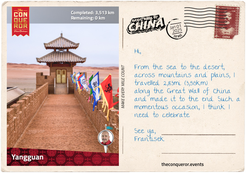
km od začátku : 3513
Yangguan
Yangguan Pass is located west of Dunhuang and it’s essentially the end of the Great Wall. It was a major stronghold on the western border of the Han Dynasty, alongside Yumenguan Pass, east of Dunhuang. Emperor Wu ordered the construction of the two passes to protect the frontier and Dunhuang. The two passes were connected by a 40mi (64km) wall interspersed with beacon towers at 3mi (5km) intervals.
Both passes served as trading posts on the Silk Road, providing food and water supplies to travellers and armies. Just like Dunhuang, Yangguan profited from the Silk Road trade, until its decline during the Ming era.
With the exception of one beacon tower, nothing else remains of the pass as it was buried beneath the sand dunes, long ago. However, there is a museum in its place exhibiting thousands of items from the two passes and the Silk Road.
The Great Wall is a remarkable structure, built by multiple dynasties across two millennia. It spans over 13,000mi (21,000km) across various parts of China. A lot of effort went into protecting the northern and northwest borders. Mountains and rivers were used as natural barriers and earth, reeds, bricks and stones were used to build and reinforce the Walls. Millions of people were conscripted to work on the Wall and many died on the job. Various ethnic groups ruled, each empire replacing the other through a series of rebellions or military campaigns.
The Great Wall is a Chinese cultural icon and a symbol of its unification. It is a representation of stoicism, cohesiveness and national pride. It has inspired paintings, poems, operas, stories and legends. But most of all it is an engineering marvel.
Let me leave you with a famous folk story called, The Tears of Meng Jiangnu:
Meng Jiangnu met and fell in love with the fugitive scholar, Fan Xiliang. Not long after they were married, Fan was found by the Imperial Guards and promptly dragged away as a prisoner to work on the Great Wall. Meng waited for him day and night. When winter came and Fan did not return, she packed some warm clothes and began her long journey to search for him. When she arrived at the Wall, she was informed that Fan had died and was buried inside the Great Wall. Devastated, she wept for days at the Wall until a section of it collapsed. There in the crumbled heap, Meng found her husband’s bones. She carefully wrapped them in his winter clothes and made the long journey home where Fan had a proper burial.
I may have started at the Old Dragon’s Head near the Bohai Sea but I think I have finally found the dragon’s tail. How about you?