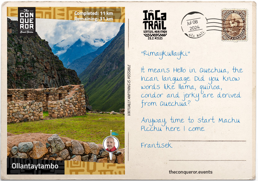
km od začátku : 0011
Ollantaytambo
Welcome to the town of Ollantaytambo, where you will begin your mountainous journey to Machu Picchu.
Surrounded by mountains, Ollantaytambo is located at the end of the famous Sacred Valley of the Incas. Conquered and razed by Emperor Pachacuti in the mid-15th century, the area was incorporated into his personal estate. Pachacuti rebuilt the town and constructed an extensive set of agricultural terraces that were farmed by yanacunas (servants of the nobility).
Up on the hill overlooking Ollantaytambo are the ruins of Pinkuylluna storehouses. Thought to have been built during Pachacuti’s reign, the structures were used to store the grain produced from the surrounding terraces. Building the storehouses high was both practical and strategic. The high altitude preserved the food due to cooler conditions and high wind, whilst the location protected the food stores in case of an attack.
The starting location is near the Ollantaytambo train station, known as Km82. Crossing the Urubamba River, the trail follows alongside the river before it commences a steep climb to the lost city of Llactapata. Re-discovered in 2003 using infrared aerial photography, Llactapata sits at the top of a steep slope amongst a small chain of ravines. Archaeological studies concluded that Llactapata was an important rest stop and roadside shrine on the journey to Machu Picchu.
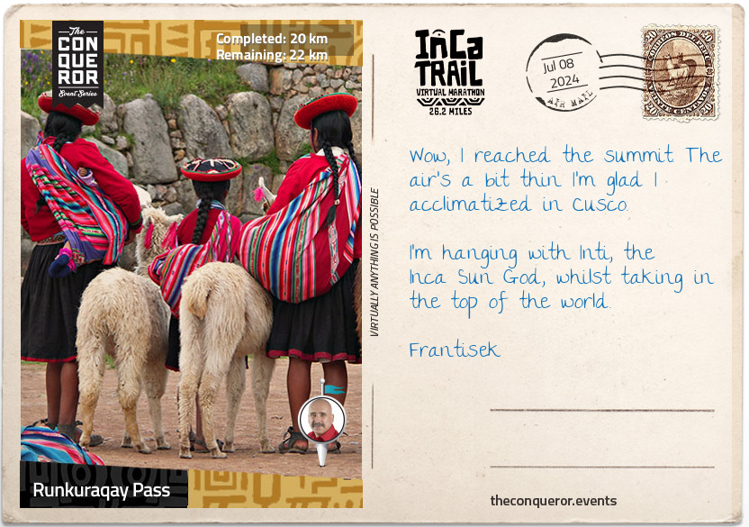
km od začátku : 0020
Runkuraqay Pass
The Inca Trail is part of a much larger road network. At the height of its power, the Inca Empire stretched 4,023km from modern-day Ecuador to Argentina. The Inca road system was one of the most advanced transportation structures of its time, linking together 40,000km of roadway. The road system provided for quick and reliable logistical support, civilian and military communication, personnel movement on official duty and control over the Empire by dispatching troops when necessary. Following the Spanish conquest in the 1500s, much of the network was abandoned and destroyed. In order to preserve the history and restore parts of the network, the Inca Road System, officially known as the Andean Road System, entered the UNESCO register in 2014.
Much of the Inca Trail is the original construction. Imagine that with every step you take, someone laid the roadway beneath your feet some 500 years ago.
The ascent to Dead Woman's Pass is both dreaded and revered. It is the most rigorous climb reaching heights of 4,215m in such a high altitude environment where the oxygen level is low, making breathing shallower and the effort needed to move forwards greater. In the same breath overcoming the difficulty and strenuousness of the climb is also the most rewarding moment.
Following a steep descent into the valley of the pass comes a second ascent to Runkuraqay Pass. On the way are the ruins of a tampu, which was an administrative and military structure used for supplies, lodgings and depositories of quipu-based accounting records.
Quipu was a record-keeping system of different knots tied in ropes attached to a longer cord. It was used in lieu of writing since the Incas did not have an alphabet-based writing system.
The tampu was served by conscripted individuals from nearby communities as part of the mit'a labor system. Mit'a was a mandatory public service used as the labor force to build roads, bridges, terraces and fortifications.
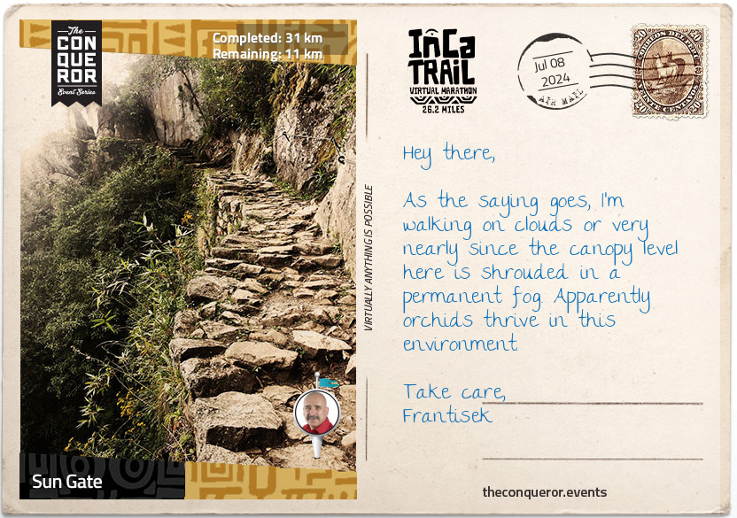
km od začátku : 0031
Sun Gate
Surfacing from the cloud forest of the Runkuraqay Pass, the trail commences its descent towards the ruins of Sayacmarca with sweeping views of the Pumahuanca Mountain.
Continue on to Phuyupatamarca, one of the most intact Inca ruins, and stop to enjoy the snow-capped view of Mt Salcantay. At 6,200m, Mt Salcantay is the tallest mountain in the region. Its Quechua name translates as wild, uncivilized, savage and, as such, is often referred to as Savage Mountain. The summit of Mt Salcantay was first conquered in 1952 by a French-American expedition. No easy feat since the "climb involves 1,800m of vertical gain, on glacier, snow, ice, and some rock."
Trek onwards to Intipata and Winay Wayna, both known for their agricultural terraces and their convex shape of the terrain, to finally reach the Sun Gate for a breathtaking aerial view of Machu Picchu. Once a fortress, the Sun Gate was the main entrance to Machu Picchu and was most likely guarded by imperial guards. Given the strict controls over entries, it is believed that only royalty and select guests were permitted to visit.
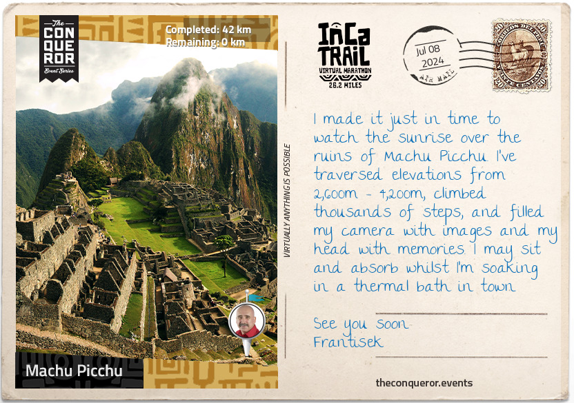
km od začátku : 0042
Machu Picchu
Voted as one of the New 7 Wonders of the World and listed on the UNESCO World Heritage Site in 1983, Machu Picchu is a 15th century Inca citadel steeped in mystery and myth. Thought to have been built on the request of the incumbent Emperor Pachacuti as a royal estate, Machu Picchu is an engineering marvel. Built without mortar, the stones are cut so precisely, they fit perfectly together. Sitting atop two fault lines, during earthquakes, the stones knock against each other and then fall back into place.
The rise and fall of the Inca Empire lasted a mere 130 years. Following the Spanish invasion of the Inca Empire in the early 16th century, Machu Picchu was abandoned, with the Spanish unlikely to have ever seen it. Left to the elements, the citadel was grown over by vegetation and forgotten over the centuries until 1911 when Hiram Bingham III of Yale University visited the site as part of an expedition in search of another city. Returning the following year, Bingham spent 4 months with local labour to clear the vegetation and the next 3 years excavating and studying discovered artifacts.
From here, the final descent into Aguas Calientes is on a hair-raising 9km zig-zag mountain road called Hiram Bingham Hwy. Barely wide enough to fit two cars and lacking guardrails, it is an unsealed road and a rough ride that is not for the faint of heart nor for those who are prone to vertigo.
Once you arrive in Aguas Calientes, book yourself into a thermal bath to rest and recover your weary body. Take a walk through the local craft market before settling in for dinner. Try the Peruvian national drink, the Pisco Sour, whilst indulging in the spicy and bold flavours of Peruvian cuisine.


