I am so incredibly excited because I have finally arrived in the seaside town of Exmouth, England. Here I will embark on a journey along the UNESCO-designated Jurassic Coast. As I travel this coastline from Exmouth to Studland, I look forward to learning about the millions of years of geology and paleontology that make up this incredible coastline.
But before I launch into talking about the Jurassic Coast, let me first tell you about Exmouth. Located at the mouth of the River Exe estuary, Exmouth is a charming port town that's been inhabited since the 11th century. It was known as Lydwicnaesse, a name derived from the Celtic word for fish. Developing as a small settlement, the town suffered from pirate raids in the 17th century, but by the 18th century, it grew into a seaside resort. Today, it is the oldest holiday resort in the county of Devon.
Exmouth has a mix of architecture from cob cottages made of natural building materials and townhouses from different eras, including Georgian, Victorian and Edwardian. There is a lovely row of period townhouses on The Beacon and another terrific collection of white, nearly uniform Victorian townhouses on the seafront promenade, distinguished only by their different coloured front doors.
A particular house of interest is A La Ronde, a quirky 16-sided house built by two spinster cousins in the late 18th century. Jane and Mary Parminter set out with Jane's sister and a friend on a European tour over several years. Returning home with trunks full of memorabilia, the cousins set about to build a home inspired by their travels and a visit to the 6th-century Byzantine Basilica di San Vitale in Ravenna, Italy. The house is three storeys high, with the attic featuring nine gorgeous dormer windows, filtering plenty of natural light. The interior contains a feather frieze in the drawing room and a shell-encrusted gallery. The two cousins were artistic and resourceful, using findings such as shells, feathers and seaweed to create their artworks. Of note was the landscape art made from sand, seaweed and shells and the bird images made with actual feathers. Among the many treasures and souvenirs are a series of incredibly detailed seashell pictures from Italy that have unbelievably survived their many bumpy road travels around Europe.
Having finished my exploration of Exmouth, I was ready to get going, take in the vastness of the English Channel and slowly peel the layers of history nestled within the coastline's towering cliffs. Made of sedimentary rock, the cliffs formed during the Mesozoic Era, also known as the "Age of Dinosaurs", spanning from 252 to 66 million years ago (mya). The era consisted of three major periods: the Triassic, Jurassic and Cretaceous. It was a time of great change that saw the rise and extinction of many plants and animals, and the layers of rock hold the story of the Earth's past.
Although there will be variables, the easiest way to picture the Jurassic Coast is that from Exmouth to Lyme Regis, I'm passing through the Triassic layer, the first period of the Mesozoic era. From Lyme Regis to Studland, I'll pass through the Jurassic layer and the most exciting period. This is where the real dinosaur action happened. Then I'll finally reach Studland with its chalky white Cretaceous layer.
I look forward to discovering this ancient landscape's mysteries, beginning with the Triassic rock as I head toward Sidmouth.
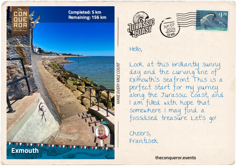
km od začátku : 0019
Sidmouth
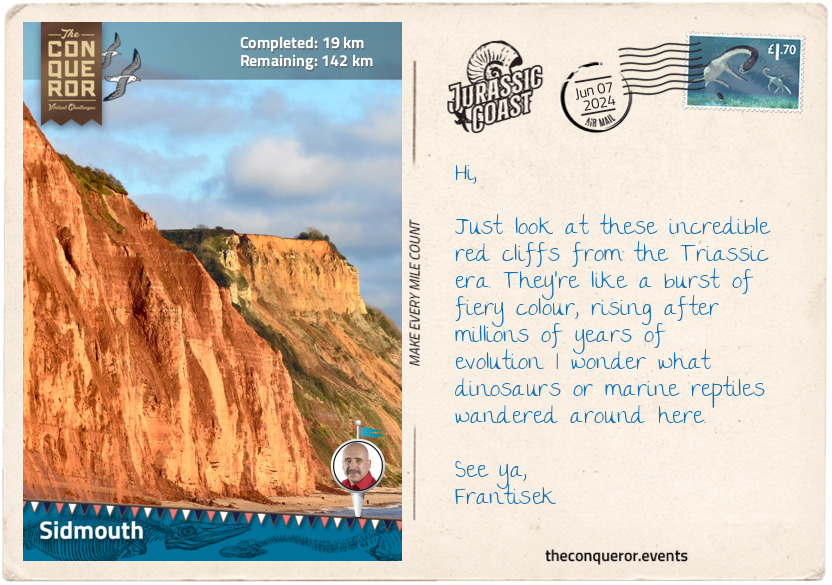
I left Exmouth along the South West Coast Path, a long-distance trail spanning the southwest of England. The Jurassic Coast makes up a portion of this path. As I passed the holiday resort in Sandy Bay, I had my first striking view of the ochre-coloured cliffs rising sharply from the sea. This was the type of coastline I travelled all the way to Sidmouth.
To explain how these cliffs formed, I need to wind back the clock a few million years when the continents were joined together in a single supercontinent called Pangaea, and Britain was in the centre landlocked. In the Triassic period (251-200 mya), southern Britain was about 20 degrees north of the equator. Today, it is around 50 degrees. Initially, the climate was seasonally strong, almost monsoonal, but later the middle of Pangaea became very hot and desert-like. It was during this period that the Triassic section of the Jurassic Coast was formed, where the rocks consist of ferric iron oxide minerals. This type of mineral contains iron and oxygen, and when the iron in the rock mixes with oxygen, it reacts and creates this reddish-brown colour seen in the cliff face. This type of deposit is referred to as New Red Sandstone, a combination of sandstone, mudstone and conglomerates, which are rocks made of rounded pebbles and large stones cemented together.
Erosion, heavy rainfalls, and changes in the rock layers impact the cliffs, making them crumbly and fragile. For instance, east of Sandy Bay is an area called "The Floors", where the cliffs formed a series of levels after several landslides. So instead of having a smooth surface, the cliffs have distinct horizontal shelves. As these shelves occur at different heights, they end up with a stepped or terraced-like appearance. These features help geologists learn about the prehistory of the area.
Past Sandy Bay was the delightful village of Budleigh Salterton, which is known for two main things. Firstly, it is the birthplace of Sir Walter Raleigh (c1554), a soldier, writer, explorer and favourite of Queen Elizabeth I. He led numerous expeditions on the queen's behalf, including to South America's fabled city of gold, El Dorado. When he was imprisoned by King James I in the Tower of London for treason, he wrote the book "The History of the World". Unfortunately, he met an untimely death by beheading.
The second thing Budleigh Salterton is known for is the shingle beach and the red-stained cliffs brimming with pebbles that were washed down from an ancient mountain range that has since vanished. Studying the cliffs up close, I can see the tough quartzite pebbles embedded in the much softer mudstone. Dating these rocks was made possible by the fossil discovery of 'the Devon rhynchosaur', an ancient herbivorous reptile. Its distinctive feature was an elongated snout that resembled a bird's beak.
As I continued my journey to Sidmouth, I marvelled at the terrific display of New Red Sandstone in the sea stacks at Ladram Bay, where the layers of red sediment compressed over millions of years were topped with green vegetation.
Walking the promenade at Sidmouth afforded me spectacular views of the English Channel, the surrounding cliffs and delightful Regency buildings. In the early 1800s, the town was a safe haven from creditors for the Duke and Duchess of Kent and their baby daughter, the future Queen Victoria. They stayed in the charming Woolbrook Cottage, known today as the Royal Glen Hotel.
Fun fact: Did you know that at one time, Great Britain was in the southern hemisphere, and it was largely submerged? We just need to roll back 514 million years to the Late Cambrian age.
km od začátku : 0032
Beer
Leaving Sidmouth, I passed a holiday resort before reconnecting with the trail. I hiked on a mix of switchbacks, leading me up and down the gentle slopes of the partially vegetated cliffs. Eventually, I reached Weston Mouth, where a small stream meandered across the shingle beach, its waters gradually finding their way into the sea. After ascending back to the cliff top, I carried on along the coastline until I again descended, arriving at Branscombe Beach.
Branscombe Beach hit the headlines in 2007 when the container ship MSC Napoli ran aground. A nasty storm cracked the hull of the vessel. Laden with more than 2000 containers filled with cargo, the ship was listing and leaking oil. At least 80 containers were washed ashore. Environmental agencies jumped into action to manage the 10,000 tonnes of spilled oil, and maritime law was enforced to prevent looting. The ship was eventually unloaded, split in two with explosives and taken away for scrapping. It took 2.5 years before the final piece of the boat was removed.
One of the highlights of my hike was reaching Hooken Undercliff. This stretch of land was formed by a massive landslide in 1790 when a 10-acre piece of land separated and slid 200ft (60m) down the cliffs, creating two distinct levels. Over time the area became a sheltered, densely vegetated spot and a haven for butterflies and birds. From the path, I could see a series of chalk pinnacles rising, reminding me of the Three Sisters in the Blue Mountains of Australia.
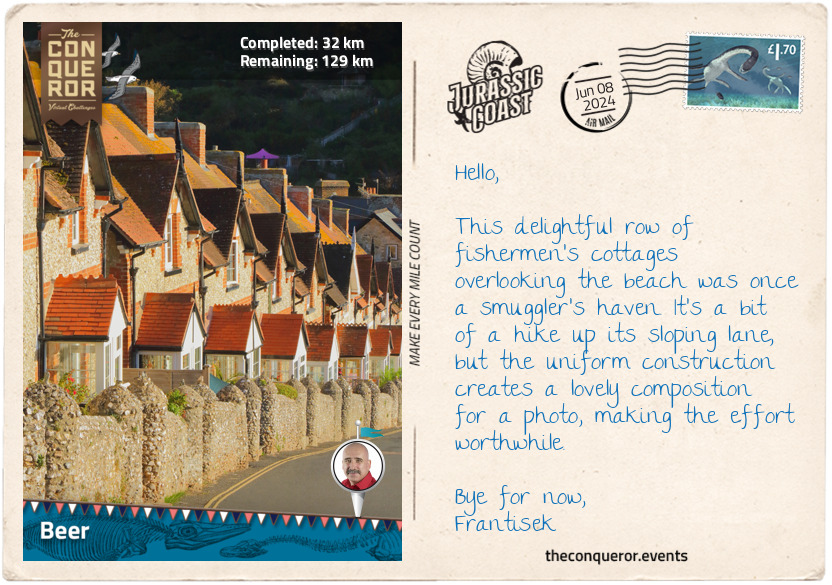
I arrived in the town of Beer, and no, it was not named after beer. It is from an Old English word 'bearu', meaning 'grove', referring to a time when the village was surrounded by forests. Anyway, the cliffs in Beer are chalk, which is usually a pretty soft and crumbly rock. However, when the chalk in Beer is quarried and exposed to air, it tends to harden, making it difficult to work with. This unique chalk type, known as Beer Stone, has been quarried in a nearby cave since Roman times. Several English landmarks, such as Westminster Abbey, Exeter Cathedral and Windsor Castle, used Beer Stone in their construction. The quarry operated for more than 2000 years. During the 19th century, local smuggler Jack Rattenbury used it to store his contraband.
What became apparent as I continued my walk was the change in the cliffs. They gradually shifted from the striking red mudstone hues to the Jurassic period's white sandstone and chalk from the Cretaceous. I was not too far from Lyme Regis and the exciting Jurassic-period coastline. Once there, I hope to engage in some fossil hunting and, if lucky, maybe find a treasure or two.
km od začátku : 0045
Lyme Regis
"The Pearl of Dorset" is how Lyme Regis is affectionately referred to. Rightly so, for many reasons. First of all, it is the heart of the Jurassic Coast and the point where the coastlines of the West Dorset and East Devon counties meet.
It was also the birthplace of renowned fossil collector and palaeontologist Mary Anning. The Lyme Regis Museum sits on the site of Mary's home. Mary was a young girl with limited education who began as a fossil-collecting assistant to her father at five. Able to read, she taught herself geology and anatomy. At 12, Mary discovered the first fossilised specimen of an ichthyosaur. More than a decade later, she discovered the complete skeleton of a plesiosaur and a few years later found the jumbled bones of a pterosaur, the first to be unearthed outside of Germany at the time. Although Mary's discoveries were attributed to scientists who purchased her fossils, she continued her scientific pursuits leaving a lasting legacy. In May 2022, a statue of Mary was unveiled in town, commemorating her contribution to palaeontology.
Many other notable figures hailed from Lyme Regis, including William Buckland and Henry de La Beche, both palaeontologists during Mary's time. Henry was a childhood friend of Mary's who painted the 1830 Duria Antiquior paleoart and sold it to raise funds for her. Joseph Lister pioneered antiseptic surgery, and Sir George Somers, an accomplished seaman and Elizabethan privateer, founded Bermuda.
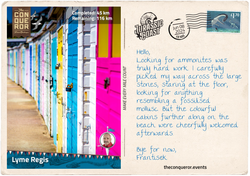
Lyme Regis is well known for its Jurrasic coastline. West of town is Monmouth Beach, where a large slab of limestone is embedded with ammonites. Dozens of huge coiled shells, some measuring up to 27in (70cm), are imprinted in the pavement, like a perfect spiral staircase. Apparently, it is the only one of its kind in the world. Behind the pavement, the cliffs are Blue Lias, a grey sequence of limestone and shale layers, with many fossils embedded within, such as the Dimorphodon that Mary discovered. The cliff's blue-grey colour results from the mineral pyrite, also known as "fool's gold", an organic matter containing pigments that give it the bluish hue.
Heading east between Lyme Regis and Charmouth is perhaps one of the best places for fossil hunting. Keen to find small ammonites or belemnites, a prehistoric bullet-shaped squid, I walked to Black Ven, a stretch of beach and cliffs between the towns. Adjacent to Black Ven is The Spittles, where Mary found the ichthyosaur. The dark-coloured cliffs of Black Ven made up of clay and shale, are continuously crumbling and falling. Because of this process, millions of fossils end up on the beach. It was here that the scelidosaurus fossil, a relative of ankylosaurs and stegosaurs, was found in 1858.
A perfect environment to hunt for fossilised marine animals, I would be happy to find a crinoid with its feather-like imprint or a gryphea, an ancient gnarled-looking oyster (aka "devil's toenails"). One thing to be mindful of when on the beach is landslides. Black Ven suffers from regular mudslide events, with 2021 being the most recent. Coastal roads are often lost during these times and cause disruptions to the South West Coast Path. As such, I made sure I stayed well away from the cliffs.
I'm off to turn over some rocks. Will write again when I get to West Bay.
km od začátku : 0066
West Bay
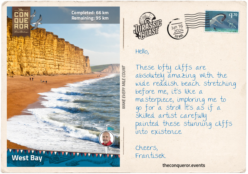
Working my way toward West Bay, I reached the highest point on the Jurassic Coast at Golden Cap. It is 626ft (191m) above sea level and gets its name from the stunning golden-coloured sandstone. From the top, I had sweeping views of the countryside as far as Chesil Beach and Chideock Beach, made of soft rose-coloured pebbles at the base of the cliff. While Charmouth is highly popular for fossil collecting, Chideock is another great location to find ammonites, especially after stormy tides when the fossils are exposed.
Five miles later (8km), I arrived in West Bay. This small port settlement became prominent after the British drama Broadchurch was filmed on location. With its expansive beach and spectacular towering sandstone cliffs, West Bay is gorgeous.
The bustling port is brimming with fishing boats and pleasure crafts, yet it's not a natural harbour. It has moved location at least three times. First, it was further inland, closer to Bridport, but the river mouth kept getting blocked by shingles from Chesil Beach. Then in the late 14th century, a new harbour was built, which prospered for half a century until the Black Death outbreak and a winter storm damaged the structure and trade. Another port was built in the 15th century until it became too small for the growing size of ships. Once again, a new harbour was made, and this time moved to its current location about 300 yards (270m) west.
I took a stroll alongside the sandstone cliffs, finding them a fascinating study. This perpendicular corrugated form has a series of ledges showcasing the layering of Lias rock. At the top is a perilous overhang threatening to crumble or fall at any minute. But what does Lias layering mean?
To understand how this layering occurred, I need to wind back 200 million years when Britain moved and ended up near a newly formed ocean that at the time covered Dorset. The ocean was inhabited by shells and ammonites, which turned into fossils when they died and settled on the ocean floor. Over time, these fossils mixed with limestone rock, forming a cement-like bond that held everything together.
Closer to shore, the bottom of the ocean consisted of sand and pebbles from rivers, which turned into sandstone. Further out into the ocean, a thin layer of mud drifted from the land and transformed into clay. Then in some parts of the ocean, remains of sea creatures mixed with a white mineral called calcite formed into limestone.
As time passed, the sea level would go up and down, and the limestone would turn into clay and then back to limestone, repeating this process with each rise and fall. So when I look at the cliffs in West Bay, I can see these different layers, like stripes, stacked atop each other. It is these striped rocks that are called lias, and each layer is a representation of the passing of time.
While the cliffs look solid, they are no safer to walk beneath than any other cliffs along the Jurassic Coast. Prone to landslips, I heed the warning, and after a short stroll close to the water's edge, I head back to the trail and ascend to travel along the cliff's grassed top, where the undulating shape of its edge moves in and out in a rhythmic pattern.
km od začátku : 0095
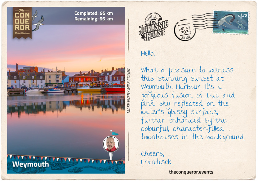
Weymouth
Weymouth is a gorgeous seaside town situated at about the halfway point of the Jurassic Coast. It has a wonderful harbour and long stretches of beach. Georgian architecture lines the promenade, while a free-standing clock tower keeps watch on the seafront. The Jubilee Clock Tower was erected in 1888 to commemorate Queen Victoria's Golden Jubilee. Made of cast and wrought iron, the clock makes a bold statement on the esplanade with its bright crimson colour.
The town's history dates back to the 12th century when it was originally two separate settlements in constant competition over trade and disputing the use of the harbour. Tired of the rivalry, Queen Elizabeth I joined the towns in the 16th century, with Weymouth becoming the prominent centre.
King Henry VIII built two castles to protect the coast from invasion. One was Sandsfoot Castle on the coast of Portland Harbour. The castle was built too close to the edge of the cliffs, and as the coast eroded, the building became unstable, forcing it to be abandoned. It eventually fell into the sea, and only a small ruined tower remains. The other was Portland Castle, a much more impressive structure built as a military fortress from local Portland Stone, a strong and durable material. The castle has a unique fan-shaped design, with a circular keep in the centre flanked by two wings. Surrounded by a moat that has since been filled in, it was accessed via a drawbridge that is no longer there.
South of Weymouth, overlooking Portland Harbour, is the National Sailing Academy. It is renowned for its sailing and watersports activities and gained prominence as the hosting venue for sailing events during the 2012 Olympic and Paralympic Games. The harbour's sheltered waters and consistent wind patterns give it excellent sailing conditions, drawing professional sailors, aspiring athletes and recreational enthusiasts to its facilities. The academy conducts sailing programs in various disciplines and regularly organises national and international sailing events, regattas and championships.
One of the main cultural markers of Weymouth is its vast amount of festivals. With more than 200 events during the year, something is always happening. Some highlight events are beach motocross, beach volleyball, dragon boat races, kite festivals, and the UK's only Sand Sculpture Festival.
As a coastal town with a commercial fishing fleet, there is no shortage of fresh seafood. With a rumbling tummy, I must now go in search of a mouthwatering serving of fish and chips or maybe a succulent lobster or a handful of plump oysters. Any delectable goody will do.
km od začátku : 0119
Lulworth Cove
The sandy beach of Weymouth eventually turned into a shingle beach. The coastline was a wonderful walk as I made my way to Bowleaze Cove, where the imposing Riviera Hotel seemed to take over the landscape. The trail passed beside the hotel and rose into low cliffs toward Osmington Hills, a pretty little holiday hamlet where a narrow path led to the rocky Hidden Beach.
Striding on, I got my first glimpse of Burning Cliff and the chalky headland of White Nothe. Burning Cliff was named after a natural phenomenon when the coastline caught on fire and burnt underground for several years. The area is composed of oil shale called Kimmeridge Clay, and one autumn day in 1826, it spontaneously combusted, emitting sulphurous fumes. The fire is thought to have been caused by heat from decomposing pyrite. A witness to the phenomenon described the event as "it threw out volumes of dense and suffocating smoke" and was followed by "bluish flames rising at times so far above the cliff as to be visible from Weymouth". Walking over Burning Cliff, I saw its charred remains among scrubland vegetation.
At White Nothe, I stopped to appreciate the picturesque views across the Channel, dotted with several cruise liners plying the waterway. The land sloped steeply toward the sea, creating a beautiful, terraced landscape. With limited access to humans, the terraced area provides a safe and secluded habitat for wildlife, like the occasional adder basking in the sun. White Nothe is composed of chalk, a pure white limestone formed from microscopic marine organisms called coccolithophores, which settle on the ocean floor and are compacted to create this type of rock. These chalky cliffs are part of the Cretaceous era when sea levels rose significantly, and the coast was submerged, allowing the coccoliths to accumulate on the ocean floor and turn into chalk.
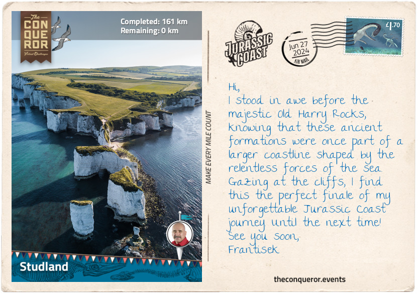
I descended from the cliffs and reached the iconic Durdle Door and its famous arch. It is composed of Portland limestone deposited 140 million years ago during the late Jurassic era. As softer rocks eroded around the limestone, it left the now-known arch. As time passes and the rock continues to deteriorate, the arch will one day collapse and Durdle Door will end up as a stack. I recall one such incident in 1990 on the Great Ocean Road, Australia, when one of the two arches on London Bridge collapsed. Following the event, the feature was renamed London Arch. What will Durdle Door be named when it becomes a stack? Will humans still be here?
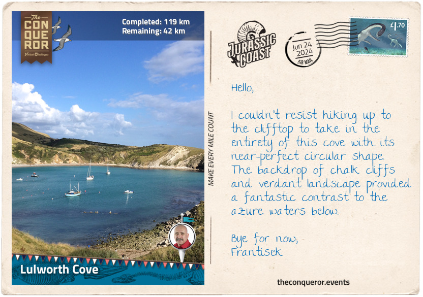
My final stop on this section of my journey was the horseshoe-shaped Lulworth Cove. This gorgeous bay featuring crystal-clear turquoise waters and steep cliffs was formed by the erosion of softer rocks, just like Durdle Door. To understand the cove's evolution, imagine the English Channel butting against layers of rock. At the front is the hardy Portland limestone (150m years old), creating a hard line where the land meets the sea. Behind it is the slightly softer rock called Puberck limestone, followed by even softer rocks like clay and greensand. A wide band of strong chalk rock is at the very back, but not as strong as limestone, making up a huge part of the cove.
The seawater slowly carved a doorway through a fault or a crack within the Portland limestone. As the water passed through, over millions of years, the softer clays and sands further inland gradually wore away, creating the cove as we see it today.
Right next to Lulworth Cove is Stair Hole, a tiny cove where the sea made a gap in the limestone rocks and started eroding the softer clays. As the sea digs away at this new cove, it will grow over time, and maybe one day, the two coves will merge. In the meantime, I envisage this is how Lulworth Cove might have looked long ago.