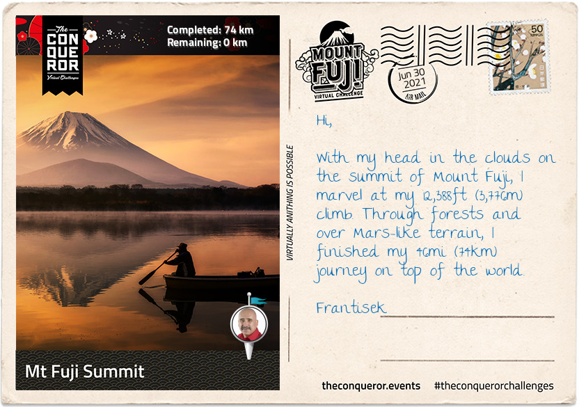
When I decided to hike Japan's tallest mountain, Mount Fuji, I pondered the best route that would capture its culture and spirit whilst travelling through its lush green landscape. The result was a 46mi (74km) journey starting at the base of the mountain, leading past lakes, caves, temples, shrines, dense forestry and ending with the final climb to the summit.
Mount Fuji is one of three holy mountains in Japan. At 12,388ft (3,776m) tall, Fuji sits atop a triple junction trench where three tectonic plates meet. Although geologists classify it as active, Fuji is a dormant volcano that last erupted in 1707. At the base it is surrounded by the Fuji Five Lakes which were formed by previous eruptions damming up the rivers with the lava flows.
Mount Fuji is a composite of four successive volcanoes meaning it's made up of layers. The first two layers were the result of an eruption more than 700,000 years ago known as Sen-Komitake and Komitake Fuji. The next eruption, about 100,000 years ago, engulfed Komitake Fuji and added the second layer creating Old Fuji. The third eruption about 10,000 years ago formed New Fuji and the summit zone producing the near perfect conical shape we know today.
Recognised as a sacred place and considered a symbol of Japan, Mount Fuji is a pilgrimage destination for practisers of Shinto. Each year between July and August, up to 400,000 tourists and pilgrims make the long trek to the summit. In 2013, Mount Fuji was added to UNESCO's World Heritage List.
Dotted throughout Japan are Shinto shrines and Torii gates. Shinto is the indigenous faith of the Japanese people and the shrines are places of worship and homes of the Kami (Gods). Practitioners come to pay their respects to the Kami or pray for good fortune. The entrance to a shrine is marked by a gate known as Torii and they symbolise the "transition from mundane to sacred". To enter through a Torii, one enters the world of the Kami (Shinto Gods).
I began my hike at the Yama Shrine near Lake Motosu, one of the Five Lakes. The third largest and deepest of the five lakes, it is subteranneously connected to Lake Shoji and Lake Saiko. Originally one lake, these three lakes were divided by one of Mount Fuji's enormous lava flows. The water temperature on Lake Motosu never drops below 39 °F (4°C) and as such it is the only lake of the five that never freezes over winter.
Northward bound, I passed by Lake Shoji, the second and smallest of the Five Lakes. On the left side of the lake you can still see large remnants of the lava flow jutting out of the water. With a greenish hue due to algae and rich in nutrients including plankton, locals can be seen standing on the lava rocks fishing.
My final stop for today was Lake Saiko, the third of the Five Lakes. With no natural outflow an artificial channel was made to connect it to Lake Kawaguchi. Lake Saiko's banks borders the Aokigahara Forest which I will write about in my next letter.
km od začátku : 0015
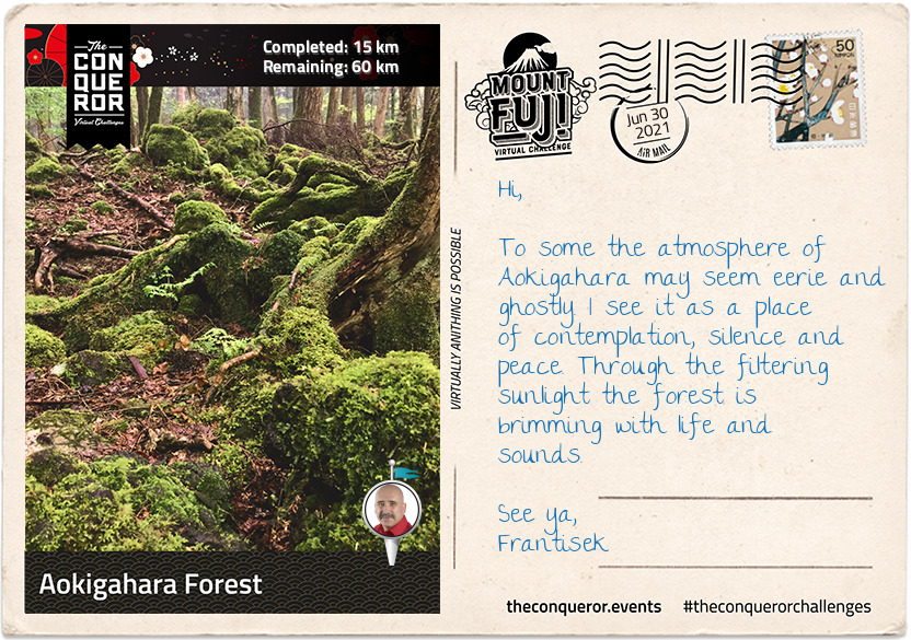
Aokigahara Forest
Aokigahara nicknamed Sea of Trees and at times infamously referred to as Suicide Forest, is a dense, moss-covered forest that sits within the Hakone Izu National Park. Registered as a National Natural Treasure the forest was born out of an eruption from Mount Fuji about 1,200 years ago, when new trees started sprouting from cooled lava. Because the forest is formed on top of dried magma, trees are unable to grow their roots deep into the ground. Although the thickness of the soil is only 10cm, the forest is filled with evergreen conifers, Mongolian oak, Fuji cherry and maple trees.
Hiking trails have been paved in the forest for visitors but anyone veering off the designated path can easily get lost and be difficult to rescue. Plastic tapes can often be seen rolled out to mark the path and assist visitors to find the way out. Then there are times when people have no intention of coming out and getting lost is a means to ending it all.
When I entered one of the trails on Aokigahara it was with the intent to find Fugaku Wind Cave and Narusawa Ice Cave. The trail was wide, well-marked and well-maintained with sunlight streaming through the canopies of the trees. I needn't worry that I might get lost.
Fugaku Wind Cave was a 659ft (201m) long lateral cave accessed via a staircase. Due to its natural ventilation and year-round average temperature of 37°F (3°C) the cave was used as a refrigerator during the 17th to early 20th century to store the eggs of silkworms.
Narusawa Ice Cave was a looped 492ft (150m) lava tube that maintained the same temperature as Fugaku and was also used as a natural fridge during the pre-electric refrigerator era. A small section of the cave was only 3ft (91cm) high where I needed to walk sideways in order to see remnants of trees from a thousand years ago. Ice pillars begin forming over the winter period here reaching their maximum size by April. They can grow up to 10ft (3m) high and as thick as 20in (50cm) wide.
Leaving the forest, trail and caves behind, I proceeded to trek through urban areas to Lake Kawaguchi.
km od začátku : 0026
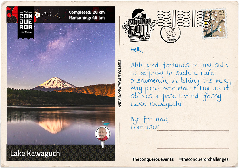
Lake Kawaguchi
Lake Kawaguchi is the second largest of the Five Lakes and has the longest shoreline of 12mi (19km). It is a popular holiday destination with well-developed resort facilities.
My hike along the southside of the lake began at Koumi Park, a sprawling green space with a narrow promenade, not particularly obvious but nicely maintained, near the shore that led to Shikkogo Park a mile away. Along the way I came across the literary monument of Junichiro Tanizaki, a popular novelist of the mid-20th century. The monument is in the form of an open book with a passage from one of his works carved in his handwriting.
I reached a cape-like place called "Sakuya Aino Kane" which translates as Sakuya Bell of Love. Near the tip of the cape is an arched structure about 13ft (4m) high with a bell hanging in the centre of it. Installed by the city of Katsuya in 2002, the arch was named after "Konohana Sakuyahime" the Shinto goddess of Mount Fuji. In Japanese mythology Sakuyahime is depicted as a blossom-princess in the image of the sakura (cherry blossom) and a symbol of delicate earthly life. It is said that if you ring the bell once love will come true and if you ring it twice your wish will come true. Of course I couldn't pass it by without ringing it at least once or maybe twice.
Veering off the promenade, I visited Fuji Omuro Sengen Shrine. The original shrine was built around the 9th century on Mount Fuji. Due to the mountain's frequent eruptions, it burnt down and was rebuilt many times. The current shrine was built on Mount Fuji in 1612 by Torri Naritsugu but in 1974 was moved to its current location for future preservation.
Naritsugu was a member of the Torri Clan, a samurai family and loyal retainers of the Tokugawa Shogunate (dynasty) from the 15th – 19th century. In 1600AD, his father Mototada changed the course of Japanese history when he refused to surrender Fushimi Castle to an oncoming enemy. With a garrison of 2,000 men, he fought valiantly against an army of 40,000, until he was the last man standing. As was custom rather than being taken alive, Mototada performed seppuku (suicide). This final stand gave his Shogun Tokugawa Ieyasu (commander-in-chief) sufficient time to escape. Ieyasu went on to raise an army of 90,000 and successfully won the Battle of Sekigahara, resulting in the unification of Japan and a ruling dynasty for the next 268 years.
Set within a dense old forest at the base of Fuji is "Kitaguchi Hongu Fuji Sengen" shrine complex. Covering 24 acres, the complex is one the largest forest shrines in Japan. The first shrine was built more than 1900 years ago when Yamato Takeru on an expedition to the east came across Mount Fuji and began worshipping Konohanasakuya-hime, Goddess of Mount Fuji. When the Edo Period (17thC) began Fuji-ko (Mount Fuji religion) spread and worshippers would begin their pilgrimage up the mountain from here using the Yoshida Route, one of four trails to the summit. Around the main shrine, trees were selected in each corner to designate the border of the area. About 1000 years old, only three trees remain today. With girths measuring 75ft (23m) the trees are believed to protect the shrine and are classified natural monuments.
Yamato has an interesting story or perhaps more like a legend himself. Born around 72AD he was the second son of Emperor Keiko, the first being his twin brother. He began his military career by first murdering his brother, simply because the Emperor was dissatisfied with his brother for failing to have his meals with the imperial household. At 16 Yamato was sent to quell a rebellious tribe. He succeeded by infiltrating the tribe dressed as a housemaid with a hidden holy sword, one of three Imperial Regalia. Upon his return home, the Emperor sent him on another mission. With his wife in tow, Yamato needed to cross the sea but a storm was hindering the voyage. His wife sacrificed herself to the sea in the hope the storm would die down and according to legend it did. Seven days later her comb washed ashore and a tomb was built around it. Yamato proceeded with his campaign and when the rivals saw his approach they surrendered immediately. Yamato never arrived home. He died of exposure at the age of 30. His aggrieved father built a mausoleum where his son died and it is believed that his soul transformed into a white bird and soared to Heaven.
km od začátku : 0040
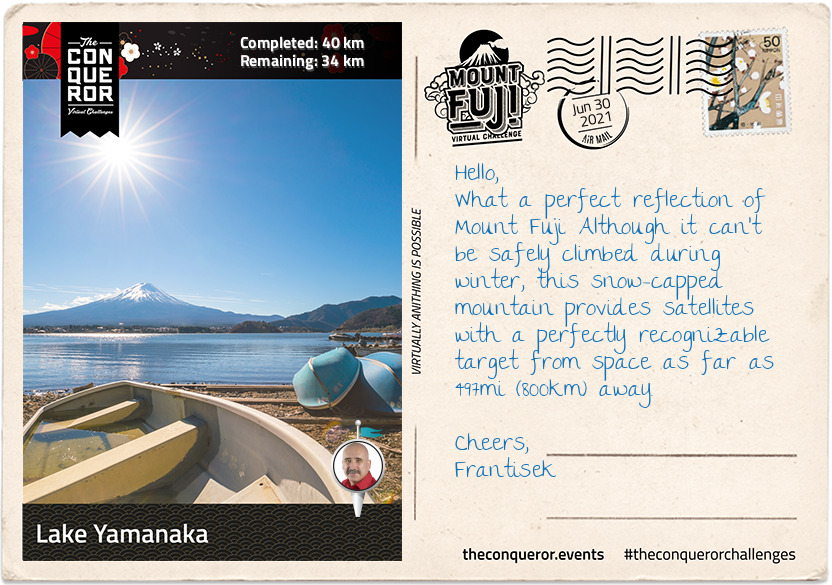
Lake Yamanaka
Just over halfway and I made it to Lake Yamanaka, the largest and the last of the Five Lakes. The lake is the only one of the five with a natural outflow, draining into Sagami River. Yamanaka is a popular recreational site for all types of watersports, boating, fishing and around the lake there are restaurants, parks, a small teddy bear museum and even a waterpark.
Back in 1985 aquatic adventurer Lynne Cox, was the first woman to swim across all Five Lakes. A long-distance open water swimmer, as part of her Swim Around the World in 80 Days quest, Lynne undertook a series of swimming challenges of which the Five Lakes was one of them. She is most famous for achieving the first diplomatic swim across Bering Strait (1987) and being the catalyst at opening the US-Soviet Border for the first time in 48 years, accomplishing the swim in 2:06hrs in 38°F (3°C) water.
There are several parks around the lake but Hana no Miyako Park is a wonderful 74 acres floral park. Every season is a kaleidoscopic display. Imagine tulips in spring; cosmos, zinnia, blue salvias or a field of sunflowers in summer; orange-red-russet colours of autumn; and whilst the soil is resting in the winter preparations are made for spring in the greenhouse.
Grapes are also harvested here to create Koshu wine, a white wine variety. Koshu wine is described as soft, fruity and aromatic with citrus overtones and considered a good match for Japanese cuisine. Yamanashi the prefecture that this Park sits within had the first proper winery established in the late 19th century. Locally grown grapes grew dramatically by the mid-late 20th century, so much so that more than 80 wineries can now be found in Yamanashi, producing 40% of Japan's domestic wine.
On a clear day Mount Fuji majestically reflects off Lake Yamanaka but right now I am more excited about finally starting the climb up the mountain.
However, before I go here's a final story. It's of Kakozaka Shrine that is on the way to the trail. The shrine is dedicated to Lord Fujiwara (Hamuro) Mitsuchika. In the early 13th century the retired Emperor Go-toba had his political manoeuvres blocked by the Kamakura shogunate. Wanting the power he believed was rightfully his, he conspired to overthrow the shogunate by gathering his allies. Lord Hamuro it seems, presented himself to the Emperor ahead of expected time, seeking an audience that was denied. He then decided to write a proposal on how to pursue the regent of the shogunate. The conspiracy was leaked to the shogunate who then launched an offensive and crushed the opposition with the force of his army. Unfortunately Lord Hamuro was captured and executed for his role in the conspiracy. His grave near the shrine has been protected by the people of Subashiri and a memorial service is held every May.
km od začátku : 0060
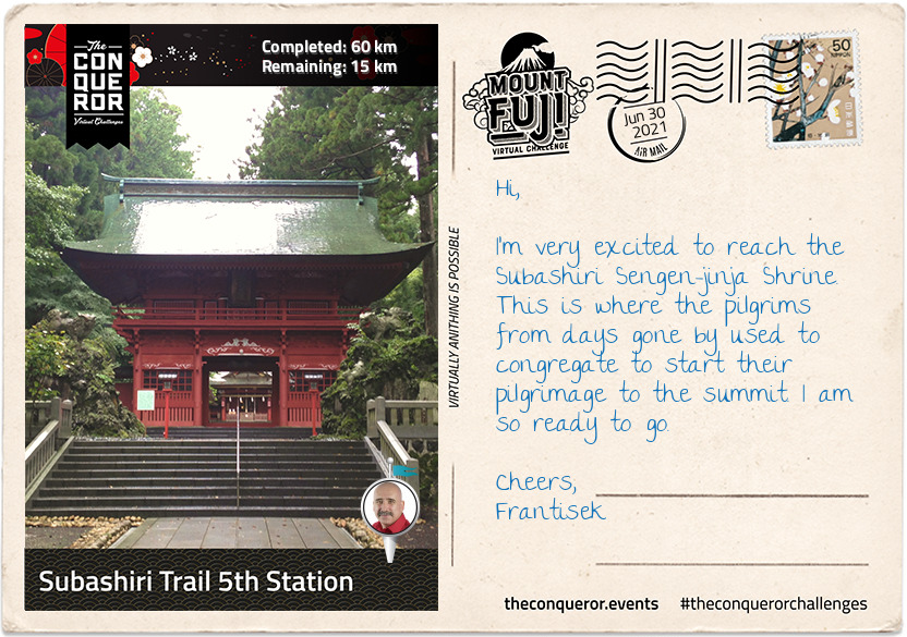
Subashiri Trail 5th Station
There are four trails to choose from to climb Mount Fuji. The most popular trail, Yoshida Trail, gets a whopping 150,000 climbers a year. Looking for more solitude and introspection I chose the less trodden trail called the Subashiri Trail, which sees an average 25,000 climbers per year. Where the Yoshida climb is from the north of the mountain, the Subashiri climb is from the east.
My target was to reach the 5th Station where the actual trail to the Summit really begins. Reaching the 5th Station can be made by vehicle but during the climbing season, which is July to September, private vehicles are prohibited from using the road. A shuttle buses services the area ferrying climbers from the base of the mountain to the station.
The ascending route to the 5th Station started at the Subashiri Sengen-jinja Shrine which was tucked away amongst giant pine trees. According to legend the shrine was built in 807AD and although it was damaged during the 1707 eruption, it was rebuilt in 1718. Followers of the Fuji-ko religion, a fusion of ancient Japanese mountain worship and Buddhism, congregated at this shrine to commence their pilgrimage to the summit. They continue to do that today and are usually seen dressed in white robes and carrying pilgrims' staffs.
Heading southwest, just before the Subashiri turn off, was a monument commemorating Prof Frederick Starr. He was a New Yorker who in the late 19th century took up a position as professor of anthropology with the University of Chicago. Upon request to undertake field work in Japan circa 1909, the Professor would eventually become a "student of Japan" visiting the country 15 times in his lifetime. He had a deep love of Mount Fuji having climbed it five times. His ultimate wish was to be buried in a place where he could always see Mount Fuji. In his words: "By climbing Mount Fuji, I found heaven on earth".
The road up to the 5th Station was a gently sloping, straight section with a beautifully manicured tree-lined road. Two miles (3km) in the landscape morphed into tall, dense pine trees until the road took a sharp, left turn and continued in a zig-zag fashion for the next 5mi (8km) up to the station. Halfway up the zig-zag the trees changed again taking on a rugged appearance indicating the kind of forest trail I will be travelling through on part of my climb.
The 5th Station is far less developed than the Yoshida Trail with limited amenities and shops, however near the main trail was a short hiking trail to a small peak called Kofuji (Little Fuji). Kofuji is a secondary peak that formed on the side of Mount Fuji and stands at 6,492ft (1,979m) tall. Access was via a nature trail through the forest. A twenty minute walk, I eventually emerged onto the peak of Kofuji. It was a large, long, oblong clearing with a beautiful 360 degree view of a lush forest, the peak of Mount Fuji to the west, Lake Yamanaka to the east and Fujiyoshida city to the north.
km od začátku : 0074
Mt Fuji Summit
I've enjoyed several days exploring the lakes, the forest, the ice caves and seeing Mount Fuji with its perfectly shaped cone from all angles but today was the day for the final climb to the summit.
Shortly after leaving the 5th Station I reached a fork in the trail. To the right was the trek to Fujiko. Heading left, I soon arrived at the Komitake Shrine, named after old Komitake Mountain which is now buried deep beneath Mount Fuji. The Shrine is important to many worshippers who each year on 1 July attend the Kaizansai festival and celebrate the opening of Mount Fuji.
From here to the 7th Station the trek weaved its way through a shady and dense forest. On hot summer days the forest provides a welcoming relief. The path itself was narrow and rough with rocks jutting out and tree branches stretching across the pathway. As with any climb sure-footedness was essential alongside some duck and weaving around branches. There were trail sections resembling carved out channels instead of just flat paths. I can imagine on foggy days this trail would be quite challenging with low visibility and for those who climb at night in order to catch the sunrise at the summit could run the risk of getting lost if not careful. Thankfully ropes line the route providing guidance and assistance up the mountain. Occasional openings in the forest canopy gave me glimpses of Fuji's peak, like small teasers of what is yet to come.
Leaving the forest zone behind, there were no more trees, just very low shrubs with small white flowers. The ground became more rocky and gravel-like, making it looser underfoot. It makes me realise that although Mount Fuji is not a technically difficult climb, it does however, present its own set of challenges such as a sudden change in weather, the steep inclines, long switchbacks and more importantly the potential for altitude sickness because the oxygen density is only two-thirds of the normal oxygen thereby making it more difficult to breathe.
I forged my way onto the 8th Station where my trail merged with the very popular Yoshida Trail. As expected it became quite congested. Taking a slow and steady approach it was time for the final push. The terrain here was barren, vegetation seemed non-existent.
I knew the summit was near when I made my way through the white Torii gate, which stood proudly on a set of steps signifying that "heaven on earth" is within my grasp.
Reaching the summit though was not the end, yet. The final part was a walk around the crater on the Ohachimeguri Trail. The crater has a 2,560ft (750m) surface diameter and a depth of 790ft (240m). With its jagged edge, the crater is encircled by eight sacred peaks, each with their own name: Oshaidake, Izudake, Jojudake, Komagatake, Mushimatake, Kengamine, Hukusandake, and Kusushidake.
My quest ended at the Kusushi Shrine near the last station. Here I stood to absorb the aerial views, reflecting on my journey and contemplating my descent but that's a story for another time.
On a final note, did you know that the top 1,312ft (400m) of Mount Fuji is actually private property? Here's an online excerpt explaining how this ownership evolved:
"... belongs to Fujisan Hongu Sengentaisha, a Shinto shrine. The land originally belonged to Tokugawa Ieyasu, the founder of the Edo Shogunate (1603 - 1867), and the area of Mt. Fuji from the 8th station to the top is said to have been given to this shrine as a gift by the Tokugawa clan in 1779. The land was re-designated as national property for a time after 1871, when the Tokugawa Shogunate relinquished power to the Imperial Court, but has since been returned to the Fujisan Hongu Sengentaisha. The Hongu (Main Shrine) of the shrine is at the foot of Mt. Fuji, and the Okumiya (Rear Shrine) is located at the mountain peak."