When I heard about the ‘City of Presidents’, I was intrigued and wanted to know more. To satisfy my curiosity, I booked a trip to Rapid City, South Dakota, USA.
Nestled in the eastern foothills of the Black Hills mountain range, the city was founded in 1876 by a group of settlers during the Black Hills Gold Rush. As prospectors, miners and entrepreneurs flocked to the area in search of wealth, the city prospered and became an important regional centre for commerce and a transportation hub.
The land that Rapid City occupies, which is within the boundaries of the Black Hills region, was originally inhabited by Native Americans, particularly the Lakota Sioux, who dominated the territory. A treaty was signed in 1868 between the United States and the Lakota Sioux, Yanktonai Dakota and the Arapaho Nation, establishing the Great Sioux Reservation that included the Black Hills. The discovery of gold in 1874 led to the terms of the treaty being broken by the United States, and the Black Hills were eventually taken from the Lakota Sioux.
When the gold rush declined, the city’s economy moved from prospecting and mining to agriculture, ranching, and tourism. The economy was further helped by the establishment of the Ellsworth Air Force Base and the presence of several government agencies, which serve as major employers.
These days, Rapid City is the second-largest city in South Dakota, and its major driver is tourism because of its proximity to Mount Rushmore, Crazy Horse Memorial, Custer State Park, and the Black Hills National Forest. All attractions I look forward to exploring on my journey.
The highlight of the city is a series of life-sized bronze statues of former presidents from George Washington to Barack Obama. Occupying 43 of downtown’s street corners, the statues were the brainchild of Don Perdue, a local businessman who wanted to “honor the legacy of the American Presidency” and bring some interest to the city’s main streets. The first installation of four presidents took place in 2000, and four more were added each year until 2010. At the time, it was decided that new presidents would only be added after they left office - Barack Obama was added in 2019, and Donald Trump is currently being sculpted. A wonderful feature of these life-sized statues is that each one matches the real president in height and weight, except for one that was trimmed to make the needed bronze more affordable. The sculptor spends significant time researching the habits, mannerisms, and interests of each president, which then helped them decide on the pose, the clothing and the unique details found on each statue, like Thomas Jefferson signing the Declaration of Independence or John F. Kennedy holding a small plane in one hand and his young son’s hand in the other.
As I walk up and down the street, I will spend some time checking out the small details of each president and maybe take a photo or two.
km od začátku : 0029
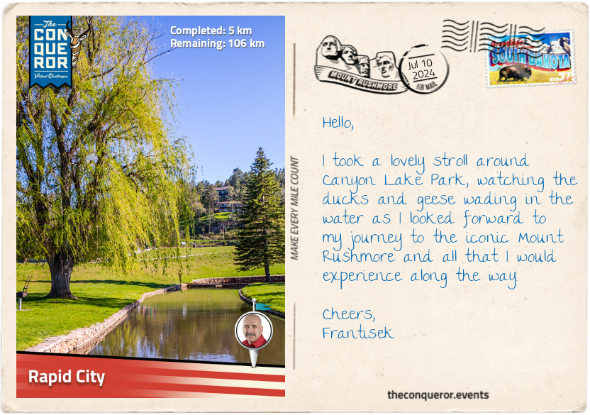
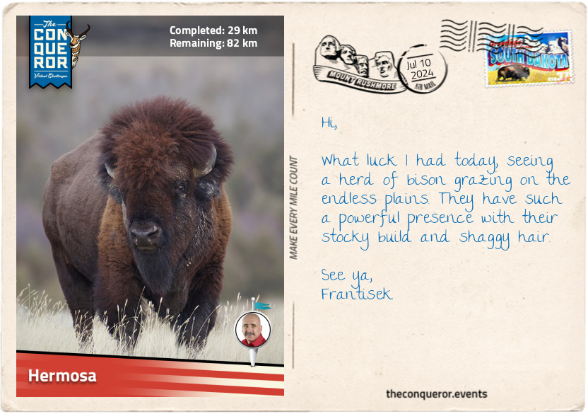
Hermosa
Having left Rapid City, I travelled south along the Heartland Expressway. I was amazed at the vast expanse of flat land, the odd farmhouse or ranch here or there, just miles and miles of open road. It felt desolate, yet amazingly peaceful, as I travelled in solitude toward Hermosa.
I can imagine, though, a time when this vastness was filled with bison freely roaming the landscape, with no roads to interfere with their crossings. These herbivorous creatures were nearly hunted to extinction by European settlers in the late 19th century, reducing the population from tens of millions to just over 1,000.
Bison were an important resource for Native Americans, who utilised every part of the animal: first as a food source, then the skin to make the teepees, the hide turned into a blanket, coat or bed, the horns were repurposed as utensils, sinews were transformed into bowstrings and thread, and the list goes on. The bison was sacred to many Native Americans, who cherished its value and treated it with deep respect.
This land I was travelling through is part of the Great Plains (the Plains). It is a massive region that stretches across the central part of the North American continent. Covering nearly a third of the United States, it extends from Texas in the south all the way into Canada in the north. Its main features are flat, wide-open spaces, extensive grasslands, gently rolling hills and few natural barriers, which makes the Black Hills mountain range rising from these plains an interesting anomaly.
Before European settlement, the Plains were home to Native Americans and held many benefits. Following the migratory patterns of bison, the Native Americans adopted a nomadic lifestyle, sourcing fresh grazing areas for their horses while hunting as needed. The Plains provided a trading network between Native American tribes, exchanging goods, culture and ideas. The flora on the Plains was fashioned into medicinal remedies, used as a food source, and turned into functional items like baskets.
Today, the Plains is an important agricultural landscape, producing various crops. In South Dakota, west of the Missouri River, ranching is the main activity, and tourism dominates closer to the Black Hills. The nearby Badlands National Park, with its otherworldly rock formations, and Custer State Park, with its lush forest and pristine lakes, showcase the Plains’ incredible diversity.
Hermosa is the eastern gateway to the Black Hills and Custer State Park. While it is a small community, one of its main attractions is the Custer County Fair, which has been running annually in Hermosa for nearly 80 years. Here, the townsfolk gather to participate in various activities such as livestock exhibitions, agricultural displays, car shows, and competitions while indulging in delicious home-baked goods and local refreshments.
Here, I will take a short break before heading into the Black Hills.
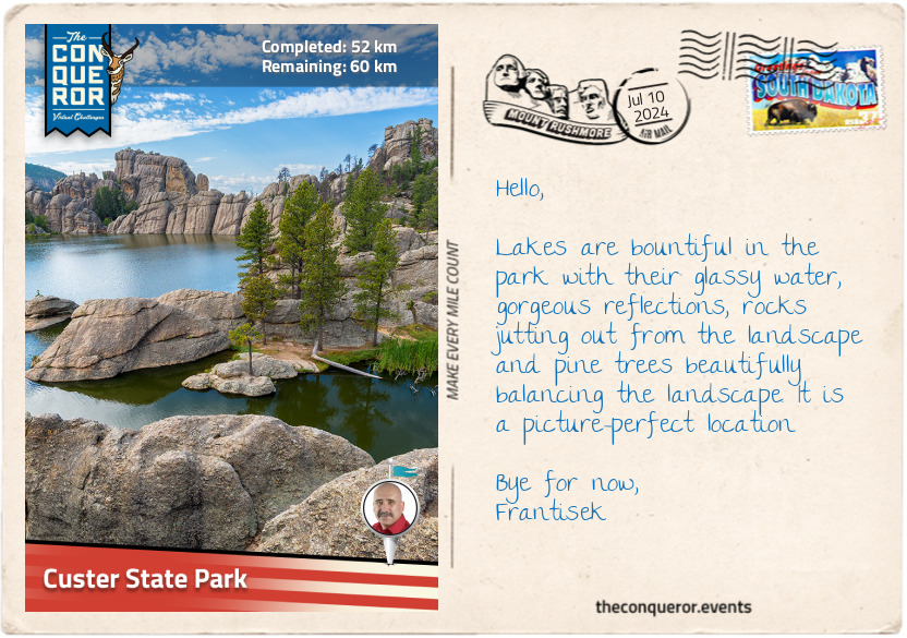
km od začátku : 0052
Custer State Park
As I entered Custer State Park, I was immediately awed by the beautiful ponderosa pine with its tall, straight trunk, distinctive bark, long needles and especially its sweet and slightly vanilla-like scent. The fragrance is quite calming, and since it’s reminiscent of the outdoors, it’s not surprising that it is a popular choice for scented products such as candles.
But there are many wonderful species within the park, from spruce trees with their evergreen needles and conical shapes to aspen groves and their yellow and gold foliage explosion during the fall. Paper birches make an interesting appearance with their papery white bark, peeling off the trunk in thin sheets, while willows thrive near streams where beavers busily use them to make dams or munch on the bark. Native Americans made medicine from willow bark because it contains a chemical similar to aspirin.
Among the trees and in the open plains are a variety of native grasses where bison, elks, big horn sheep and pronghorn graze. Native to South Dakota, the pronghorn is the fastest mammal in the Western Hemisphere, reaching speeds of 55 mph (88.5 km/h). Their unique anatomy allows them to adapt to such speeds, having large lungs and hearts and specialised leg muscles that store energy, allowing them to maintain high speeds for long distances.
The cheekiest ‘immigration’ to the park occurred in 1924 when six mountain goats escaped a small zoo. They loved the park so much that they stayed, and their descendants, numbering over 400, populate it today. Perhaps the wild burro (donkey) is the most humorous wildlife that continues to entertain visitors. Originally brought to the region by miners working the Black Hills in the mid-1870s, their descendants roam part of the park, often blocking the road, unashamedly approaching vehicles begging for food. Unsurprisingly, they are referred to as Begging Burros.
Custer State Park is a special place in South Dakota, being the oldest and the largest state park, covering an area of 71,000 acres. When travelling through the park, a wonderful experience is driving on the Needles Highway, a winding, narrow road passing rugged terrain, granite spires, rock formations and dense pine forests. A bit of excitement gathers when heading through a couple of single-laned low-clearance tunnels so tight that if I were to put my hand out of a car window, I’d be able to touch the rock wall. The tightest is the Needles Eye Tunnel, 8'9" wide by 9’8" high (2.7m x 3m), and the highlight near here is the Needle Eye, a unique rock formation that looks like a needle’s eye because at the top is an opening that was eroded by wind and rain.
Since I am heading toward Crazy Horse Memorial, I will give the highway a miss at this time and continue on the main road.
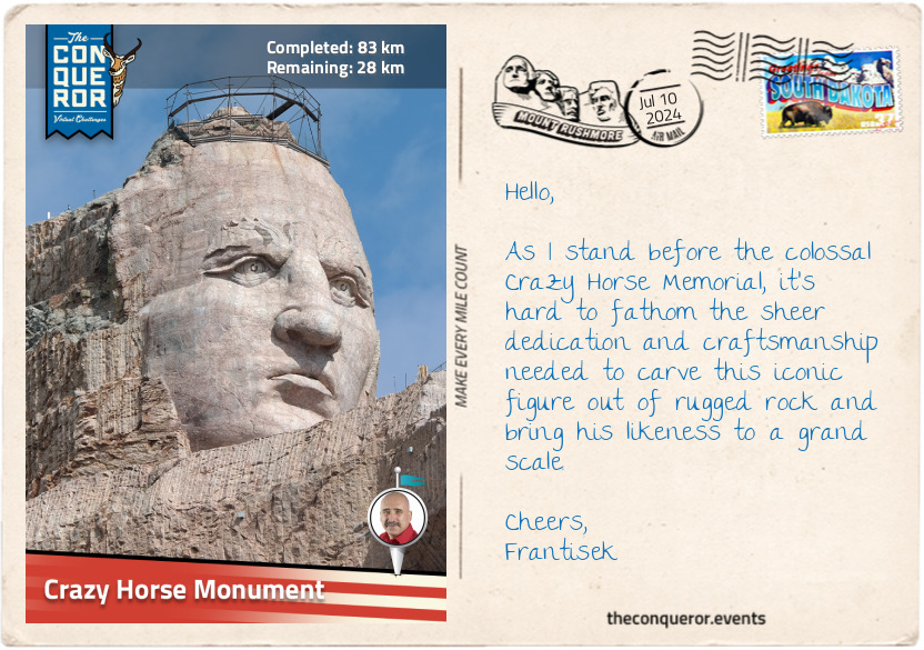
km od začátku : 0083
Crazy Horse Monument
The size of the Crazy Horse Memorial was astounding. Seen from more than 1.5mi (2.4km) away, this ongoing mountain carving project is dedicated to Crazy Horse, a Native American leader of the Oglala Lakota Nation. He played a key role in the resistance against the encroachment of European settlers on Native lands in the latter 19th century.
Crazy Horse, known as Tȟašúŋke Witkó in Lakota Sioux, was born sometime in the 1840s – the precise date is in dispute. He demonstrated bravery from a young age, and when he was a teenager, he had a vision of a man on horseback who told him not to wear a war bonnet, not to tie up his horse's tail (even though it was common Lakota practice), and never to take trophies in battle. Instead, he should rub dust on his body before going into battle. The most surprising part was that the man said Crazy Horse would not die at the hands of an enemy or from a bullet.
Crazy Horse took these instructions to heart and followed them throughout his life. His exceptional warrior skills and tactical leadership earned him respect within his tribe and beyond. Wanting to protect his tribal lands and preserve Lakota culture, he opposed treaties that led to that loss. Crazy Horse participated in the Battle of Little Bighorn in 1876, also known as Custer’s Last Stand, where he fought against the U.S. Army's 7th Cavalry Regiment led by Lieutenant Colonel George Armstrong Custer. He and other tribal leaders, including Sitting Bull, coordinated the defensive strategy and tactics that ultimately led to the defeat of Custer and his regiment.
A year later, defeated in another battle and pursued by the military, Crazy Horse knew that surrender was inevitable, leading his followers to Fort Robinson, Nebraska. While in captivity, a confrontation broke out and, shortly after, he was fatally wounded and passed away later that day. Crazy Horse became a symbol of Native American resistance and pride, and various memorials were established in his honour, such as the Crazy Horse Memorial.
The idea for the memorial was conceived by Henry Standing Bear, a Lakota elder, in the early 1940s. Construction began in 1948 with Korczak Ziolkowski as the principal designer, who also worked on Mount Rushmore. Korczak dedicated the rest of his life to carving Crazy Horse’s likeness into Thunderhead Mountain, a legacy his family continues today, with his daughter leading the project.
Since there are no known photographs of Crazy Horse, Korczak had to rely on historical accounts and individual descriptions such as facial features, hairstyle and clothing. He consulted significantly with Native American elders, aiming to capture his spirit and a portrayal of his face. As such, the memorial is an artistic representation and interpretation.
The memorial is a long way from completion, but when it is completed, it is expected to be the largest in the world, measuring 641ft (195m) long and 563ft (172m) high. The final design is intended to depict Crazy Horse riding a horse with his outstretched arm pointing into the distance.
The nearby cultural centre features a museum illustrating Native American history, and outside the building is a large model of the planned sculpture.
However, the memorial is not without controversy. Some Native American groups believe that the memorial is not an appropriate way to honour Crazy Horse and that it further disrupts sacred land. Others feel the project provides an educational opportunity about Native American history and culture.
Crazy Horse lived and died in a complex period in North American history, and his story and legacy are preserved through oral traditions, which elders and storytellers pass down to younger generations.
km od začátku : 0095
Black Hills
The Black Hills is an isolated mountain range that rises abruptly from the surrounding landscape, setting it apart from the nearby Rocky Mountains to the west and the Great Plains stretching to the east. Comprised of granite and metamorphic rock, these mountains bear a dark hue, which inspired their name, “Black Hills”.
The range holds immense spiritual and cultural significance to Native Americans, particularly the Lakota Sioux, who refer to them as the Pahá Sápa (Black Hills) or Ȟe Sápa (Black Mountains) in their language. According to Native American traditions, the Black Hills mark the sacred centre of the universe, where Earth meets the sky. Here, ceremonies, prayers, and cultural practices were held. The hills provided a place for gathering food, medicinal plants and building materials.
The highest point in the Black Hills and the United States east of the Rockies is Black Elk Peak, with an elevation of 7,244ft (2,208m). It was formerly known as Harney Peak; however, in 2016, it was renamed to honour Nicholas Black Elk, a highly respected Lakota medicine man and spiritual leader, for his contributions to preserving Native American heritage and in recognition of the mountain’s importance to Native Americans.
A stone fire lookout tower was built in the 1930s on the peak’s summit, which today is accessible for panoramic views of the diverse landscape, such as the towering granite spires and rocky outcrops jutting from the forested terrain. At the tower’s base are the interred remains of Valentine McGillycuddy, a surgeon who came to Crazy Horse’s aid when he was wounded and who was known for his “effort to build a sustainable relationship between the United States and the Native American people”. Oglala Lakota leader Red Cloud, nicknamed Valentine Wasicu Wakan, meaning Holy White Man, words noted on the installed plaque. Initially, Red Cloud was not fond of Valentine, but with time, observing Valentine’s efforts to help the Lakota, he grew to respect him and bestowed him with a Lakota name.
The Black Hills has a fascinating landscape and complex geology built in layers. At its core is ancient granite, formed about 1.8 billion years ago, surrounded by older metamorphic rocks and topped with sedimentary layers formed over different geological eras. When the uplift began around 80 million years ago, igneous rocks stacked themselves on top of the original ones along with gravel along its slopes, creating a visually captivating environment.
The Ponderosa pine dominates the hills, and as the name suggests, Black Hills spruce, known for its evergreen needles and conical shape, is native to the area and thrives here. Among these two primary tree species, the quaking aspen, paper birch and bur oak bring variety to the landscape, while flowers such as bergamot, blackeyed Susan and pasqueflower bring a pop of colour and mountain meadows are scattered through the hills.
Within this varied environment, the wildlife is just as wide-ranging. White-tailed and mule deer are often spotted foraging in forested areas. At the same time, elk are frequently seen in open meadows grazing. Elusive predators like mountain lions keep a close eye on their prey and stay in the shadows. Among the bird species found exclusively in the region are the pinyon jay, three-toed woodpecker, ruffled grouse, and the American dipper.
A journey through the Black Hills is filled with wonder, history, nature and abundant wildlife. It’s a visual feast brimming with unusual rock formations, lakes, winding roads, challenging trails, and a heady fragrance released by the ponderosa pine forest.
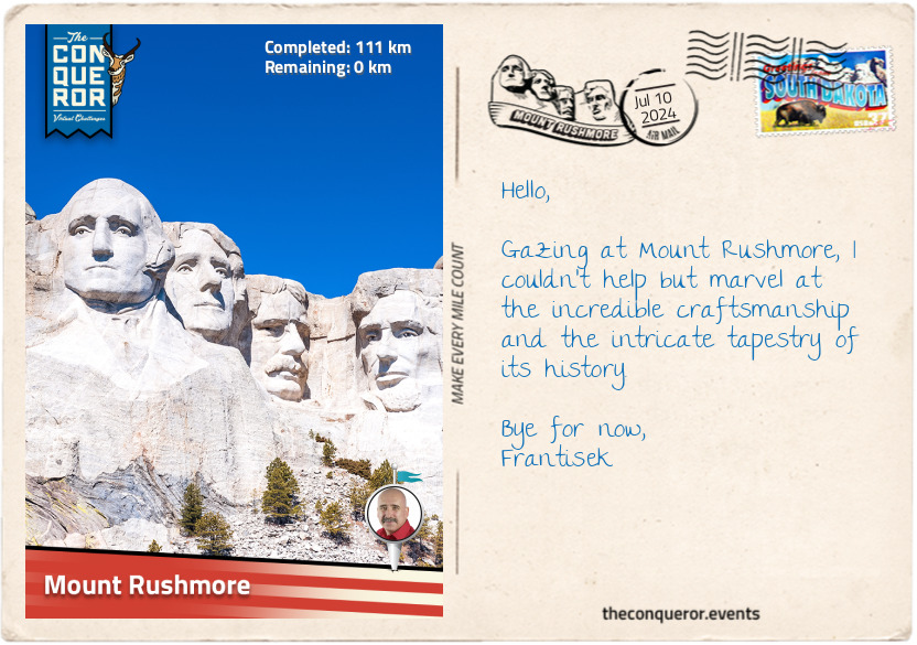
km od začátku : 0111
Mount Rushmore
Known by the Lakota Sioux as Tȟuŋkášila Šákpe Pahá, or Six Grandfathers Mountain, the granite formation that would later become known as Mount Rushmore, is located just south of the United States geographical centre. It's not surprising that Native Americans considered it the centre of the world. For the Lakota Sioux, the Six Grandfathers represents the "supernatural forces responsible for Lakota creation: North, South, East, West, the sky above, and the Earth below." It was a sacred mountain reserved for prayer and devotion, where the spirits of dead warriors lived, and young braves went on vision quests.
In the early 1920s, a South Dakota historian named Doane Robinson had an idea to sculpt a grand monument into a mountainside, hoping to draw visitors to the state. Robinson reached out to the renowned sculptor Gutzon Borglum, who travelled to South Dakota to assess the possibility of the construction on Mount Rushmore. Borglum concluded that the hard granite was ideal for carving a visually striking sculpture that could endure the elements and stand the test of time.
Borglum also sought a site easily accessible from nearby towns and appreciated that the mountain faced southeast, receiving sunlight most of the day. With that in mind, he selected four presidents to carve, each representing an important event in the country’s history:
George Washington – the birth of the United States
Thomas Jefferson – the growth of the United States
Theodore Roosevelt – the development of the United States
Abraham Lincoln – the preservation of the United States
Construction began in 1927. Initially, Borglum envisioned carving the monuments down to the presidents’ torsos. However, he underestimated the challenges of working with hard granite, and financial constraints were an ongoing difficulty. The carving process began with extensive rock blasting, after which sculptors utilised sling seats to hang in front of the cliff and shape the sculptures.
When Washington’s carving was finished, Borglum hired another sculptor to carve Jefferson while he was abroad. Unfortunately, Jefferson, carved on the left of Washington, was an incorrect size, leading Borglum to blast Jefferson off the cliff and reposition him to the right of Washington. When carving Roosevelt, they faced challenges due to cracks in the rock. They had to remove a huge amount of stone, leaving only 30ft (9m) before reaching the canyon behind. Undeterred, Borglum pressed on and successfully added Roosevelt’s likeness, including a fine outline of his glasses.
Borglum passed away six months before Mount Rushmore's completion. His son, Lincoln, continued the work, adding the finishing touches. In October 1941, Mount Rushmore was declared completed. The monument stands approximately 60ft (18m) high and took Borglum and 400 workers fourteen years to complete.
Walking toward the viewing terrace, I passed through the Avenue of Flags, a pathway bordered by 56 flags representing the 50 states, districts, commonwealths, and territories of the United States. To get a closer look, I walked the Presidential Trail that brought me right beneath the colossal structure.
Finishing my walk back at the viewing terrace, I took the time to contemplate all I had encountered and learned on this journey, understanding that history is full of challenging situations, such as the complex relationship between the United States and Native Americans. Mount Rushmore's location in the Black Hills, a region sacred to the Lakota Sioux, is a reminder of the struggles that have shaped the country and its stories and shared history are etched into the granite faces of the presidents and the landscape itself.