Australia, known as the "Land Down Under," boasts a coastline spanning 37,000mi (59,000km) and more than 20,000 beaches. Due to its geographic isolation and evolutionary history, its incredible coast varies significantly from east to west and north to south. The eastern seaboard is all about sandy beaches, lush national parks and rocky headlands. The west coast has mostly rugged cliffs, secluded bays, and arid land, while the north is tropical, and the south is quite cool. These diverse regions have developed wonderfully unique flora and fauna found nowhere else on Earth.
Exploring any part of Australia is a huge endeavour, given the sheer vastness of this continent and choosing which part of the coastline to explore is a monumental task in itself. Taking into consideration the various options, I settled on the New South Wales (NSW) coast with its closely nestled seaside towns, numerous national parks, including the heritage-listed Royal National Park, Sydney's iconic landmarks, Hunter Valley wine region and, of course, the endless beaches, white sand, surf and watersport options.
To embark on this journey, I arrived in the charming town of Eden, the most southerly town in NSW. Located halfway between Sydney and Melbourne, Eden was once considered a potential site for the Australian capital. While the capital was built elsewhere, Eden became a very important whaling centre in the country.
Whaling ships have been gracing these waters since 1791, with the first whaling station established in 1828. Initially, orcas (killer whales) were seen as a nuisance when, during migration season, they would arrive in Twofold Bay in Eden looking for food and got in the way of the whalers' catch. Whalers discovered a special connection between the Thaua People and the orcas, known as "Beowa." These orcas helped herd baleen whales into the harbour for the Thaua people. In return, the orcas were given the lips and tongue of the prey as food, leading to the unspoken rule, "Law of the Tongue". Observing the success of the Thaua People, whalers developed an unlikely partnership with the orcas, especially with the pod leader known as Old Tom, a male orca measuring 22ft (6.7m) and weighing 6 tonnes. They helped each other for the next 40-odd years until Old Tom, distinguished by his long dorsal fin with a bend at the top, was found washed ashore in 1930. He was so revered and respected that one of the whalers funded the Eden Killer Whale Museum to preserve and display Old Tom’s skeleton.
As I wandered around the museum checking out the displays on shipping, whaling, fishing and anything else maritime-related, including Old Tom’s story, a sound went off, alerting visitors that a whale was seen in the bay. Not losing any time, I took a short sprint to the whale-watching platform near Aslings Beach and squinted toward the horizon, watching for any whale breaching. This is the perfect place for such an experience, as Eden is one of the best whale-watching spots in Australia, as humpback whales make their way south to Antarctica or baleen whales with calves in tow spend a few days in the area feeding and playing before continuing on what is affectionately called as the Humpback Highway.
I finished my day in Eden at the Aslings Beach Rock Pool, a short hike from the whale-watching platform. The rock pool is a beautiful natural wonder with crystal-clear seawater surrounded by stunning pink and white cliffs. After a nice dip in the water, I relaxed at one end of the pool, enjoying the brilliant view of the Tasman Sea, sandy beach and rugged coastline.
km od začátku : 0029
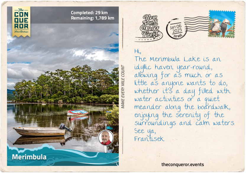
Merimbula
I left the tranquil coastal town of Eden and headed north toward Merimbula, eager to explore whatever I encountered.
My first stop was at Pambula Lake to take an oyster farming tour because I had heard that the Sapphire Coast is where the best oysters can be found. Some say they are the best in the world, and there’s nothing like having the renowned Sydney Rock oyster straight from the lake. Of course, I had to earn my oyster by learning to shuck it safely, wiggling the knife between the shells until it popped and then gently loosening the oyster from the shell. A squeeze of lemon amplifies the flavour, which is easy to carry when out on a lake. However, if I were in a restaurant, I’d be asking for Oysters Kilpatrick because I love the flavour of tomato sauce (ketchup) mixed with Worcestershire Sauce drizzled on the oysters, topped with bacon bits and baked in the oven. Hmm, I can practically taste it already.
After the lake, I passed through the historic town of Pambula, where the nearby Panboola Wetlands are brimming with birdlife. But before the wetlands existed, the area was home to the Thaua people, who thrived on the abundance of seafood from the Pambula River and rich wetland vegetation. The Thaua were deeply connected to the land through their cultural practices and spiritual beliefs. With the arrival of European settlers in the 1830s, the land was developed until the mid-1990s when a local resident purchased a parcel of land to establish a waterbird sanctuary. Further purchases over succeeding years helped develop the current Panboola Wetlands, where a wide range of birds, such as royal spoonbills and purple swamphen, call it home, and birdwatching and bird photography are a favourite pastime. Bird sculptures are dotted throughout the reserve, and winding paths offer cycling and bushwalking opportunities alongside mangroves, swamp marshes, grassy plains and a freshwater billabong.
Merimbula is a holiday hotspot during the summer months, as families on road trips descend on the town for their vacation. Arriving during a quieter time, I wasted no time immersing myself in the many watersport activities on Merimbula Lake. I challenged myself on a stand-up paddleboard, requiring a significant amount of core strength, followed by a kayak paddle and finished with a refreshing swim.
Once back on dry land, I meandered around the lake’s edge on a boardwalk, passing mangrove forests, eucalyptus trees, and nearby oyster estuaries. It was an easy 2mi (3.4km) return walk, ending my day at Mitchie’s Jetty. I savoured a delicious serving of fish and chips as I watched the sun dip below the horizon. It was a moment of sheer delight, satisfied with my day of exploration.
km od začátku : 0098
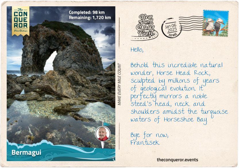
Bermagui
Leaving the sunset behind in Merimbula, I started my morning on the road again, excited about today’s adventure. I traveled through Bournda National Park, a wonderful park featuring the large saltwater Wallagoot Lake. The traditional owners of the land are the Dhurga and Yuin people, who lived off the land for thousands of years and quarried to make tools. The name ‘Bournda’ means ‘place of tea tree and kangaroos’, evident in the tea-tree-stained lake and ample kangaroos roaming the park. The park also features Bondi Lake, a freshwater lake close to the ocean, and Bournda Lagoon, a half-freshwater and half-saltwater swimming hole that occasionally opens to the ocean. Right next to the lagoon is access to Wallagoot Beach, which leads directly to the lake. In between all this are numerous hiking tracks.
My next stop was Tathra, a small seaside resort home to the last coastal steamer wharf in NSW. Built in the 1860s, the wharf was the last departure point for the iron steamer Bega, a reliable vessel that for 25 years plied the south coast shipping lanes from Eden to Sydney. Bega found its fateful end when it departed Tathra in April 1908 heading for the Commonwealth Bank, laden with cargo, livestock and gold coins, and succumbed to instability, possibly due to incorrect packing, although this was never determined with certainty. Shortly after its departure, the vessel began listing, taking on water at the bow, which slowly entered the deck spaces below. Unable to rebalance, the captain ordered everyone onto lifeboats. Sadly, an elderly passenger died after suffering a heart attack during the commotion. Staying afloat in boats and rafts overnight, the remaining 61 passengers made it to shore more than 12 hours later. The wreck was discovered in 2004, 76 metres below water, north of the town. Bega is now a protected wreck under the Historic Shipwrecks Act, and diving to the site requires a permit.
Continuing my journey, I passed through Mimosa Rocks National Park, which is significant to the Yuin people. The park got its name from the paddle steamer Mimosa that ran aground at its northern end in 1863. The rocks in this area have a fascinating, craggy, castle-like appearance, shaped by the forces of folding, fracturing, and new rock formations. It's said that catching the sunrise at Bunga Head transforms these red lichen-covered rocks into a stunning sight against the backdrop of the pink morning hues.
The park is close to the Ulladulla to Merimbula Important Bird Area, where swift parrots rely on the forest’s spotted gums and flowering eucalypts for food. At 10in (25cm) long, the swift parrot is primarily green with a turquoise crown and red patches above and below the beak. Breeding in Tasmania during the summer, the species migrates across the Tasman Sea yearly to the Australian mainland in search of food. Voted Bird of the Year in 2023, these critically endangered birds are found only in southeastern Australia.
As I entered Bermagui, I headed straight to Blue Pool, another ocean-fed rock pool. It is one of 100 along the NSW coast, and I’m sure I’ll experience many more along my travels. I climbed down the cliff to find an Olympic-sized swimming hole, which was expanded to its current size in the early 1930s. Diving in for a refreshing swim, I dipped my head underwater to find the pool floor teeming with marine life, such as anemones, sea snails and crabs.
After a splash in the pool and some underwater exploration, I dried off and wrapped up my day at two nearby ancient rock formations. The Horse Head Rock, which, no matter the angle viewed, clearly resembled a horse, and the Camel Rock, aptly named after the camel hump-shaped feature. At 500 million years of age and created by underwater avalanches, they are some of NSW's most ancient rock structures.
km od začátku : 0132
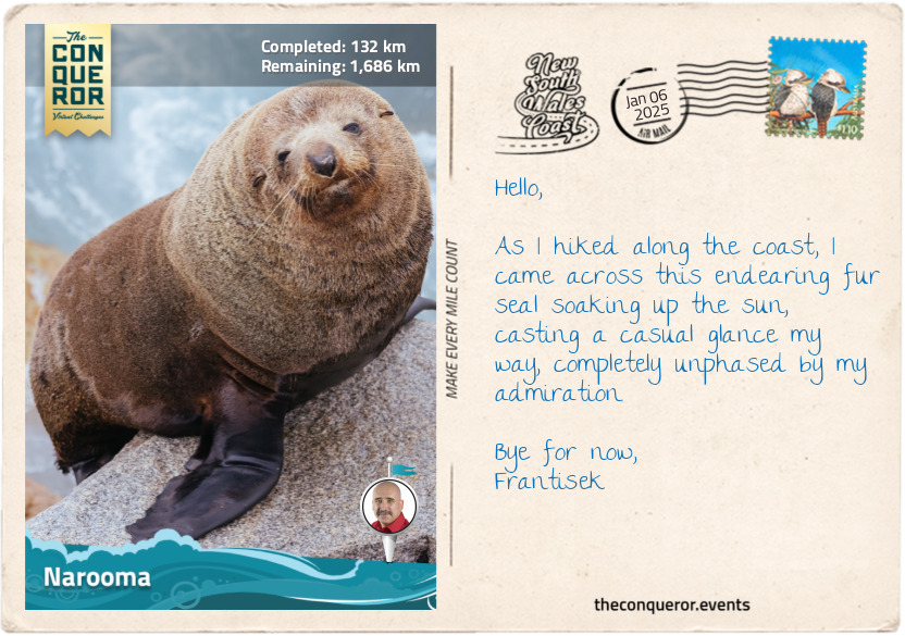
Narooma
Narooma was a delightful coastal town surrounded by the ocean, lakes and rivers. As I strolled along Wagonga Beach, shaped like a graceful fan, I was mesmerised by the twinkling, azure waters flowing between the breakwaters into the ocean.
Venturing to the opposite side of the beach, I walked to the hilltop lookout, letting the soft breeze brush my face and ruffle my hair as I breathed in the warm, salty air. At the bottom of the lookout was a rock formation naturally carved in what seemed like the shape of Australia, which, unsurprisingly, was called Australia Rock. But it was the lively inhabitants of Seal Rocks that truly stole my heart as I watched the local seals bask in the warm sunlight, playfully frolic in the water, and engage in friendly sparring, each vying for their spot to laze upon the sun-drenched rocks.
Eager to explore the waterways of Narooma, I hopped on a boat ride to enjoy the tranquility of Wagonga Inlet and the native greenery lining the shores. As the boat glided across the inlet, I imagined casting a line into the water. Reeling in a nice catch would have made for a terrific barbie, as they say in Oz (BBQ for most folks), with a squeeze of lemon and a Mediterranean marinade of garlic, paprika, cumin, tomatoes, onion, and capers. Hmmm, finger-licking good.
Instead, binoculars in hand, I scanned the skies and the horizon, hoping to catch a glimpse of herons or ibises, and I was rewarded with an osprey. Have you ever seen them swoop above the water to catch their prey? From heights as high as 100ft (30m), they pluck the fish from the water with their curved claws, then cleverly carry them headfirst to minimise wind resistance.
However, the highlight of my journey was a short side trip to Montague Island, where hundreds of fur seals frolicked among the island's granite rocks. Eager to swim with them, I donned my snorkeling gear and jumped in the crystal-clear waters surrounding the island. To my delight, the playful seals were not shy at all. They came in droves, curious to investigate me, a strange creature in their midst, with arms as flippers and legs as fins. It was a truly magical experience, made even more special by the wonderfully sunny day that bathed the underwater world in bright, clear light.
Eventually, as the day drew to a close, I reluctantly bid farewell to the seals and Narooma. With my heart filled with cherished memories, I continued up the coast toward Moruya.
km od začátku : 0209
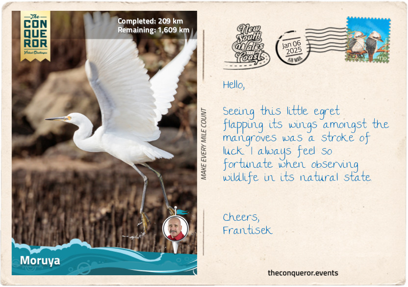
Moruya
A name like One Tree Point Lookout must raise anyone’s curiousity, including mine. I was delighted to discover this lovely spot in Tuross Head, overlooking the ocean flanked by pristine beaches with a single tree at the end centre of it. It’s a great place to picnic under the shade of the tree while whale watching or dolphin spotting.
The waterways here are a true paradise for watersport enthusiasts. Tuross Head is on a headland between Tuross Lake to the south and Coila Lake to the north. As Tuross River meanders into Tuross Lake and toward the ocean, it develops a system of channels and backwaters that become the perfect playground for kayakers and anglers.
I arrived in Moruya, situated on the banks of the Moruya River. It is a quiet town steeped in history, especially surrounding Granite Quarry, which was highly regarded for the quality of the granite. In the early 20th century, around 250 stonemasons from Australia, Scotland and Italy moved to Moruya, where they quarried over 173,000 blocks of granite to dress the pylons and piers of the iconic Sydney Harbour Bridge. The quarry closed in 1932 after 7 years in operation.
Today, Moruya is known for its weekly farmers market, where local producers offer fresh and locally grown and harvested goods. After buying some fresh veggies for my cheese, I took a gentle paddle on the river to observe birds frolicking. My highlight was the Australian pelican stretching its incredible wings. Primarily white, the pelican has black wings with a wingspan of up to 10ft (3m). It’s also known to have the longest bill of any bird in the world, with the longest on record measuring 20in (50cm). After a few cormorants, black swans (a native of Western Australia) in flight and a sunken sand barge, I wound up my day and headed for the local bakery, where I’m told that the lemon-filled doughnuts are a must-have.
The next destination is the very popular Batemans Bay.
km od začátku : 0249
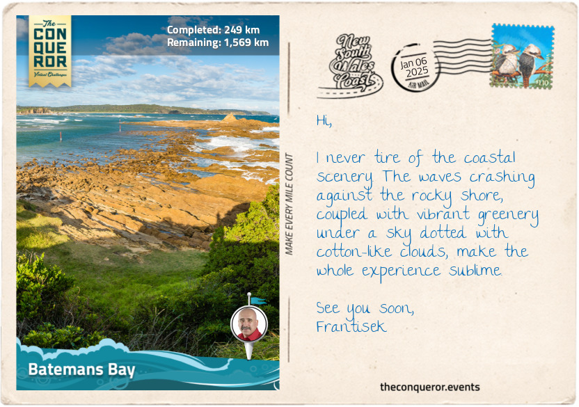
Batemans Bay
Located on the Eurobodalla Coast, Batemans Bay is the largest town in the region and a popular beach destination, particularly for travellers from Canberra, the capital, owing to its proximity. The town lies within Walbunja Country, traditionally owned by the Walbunja people.
The bay’s name was given by explorer James Cook while on his first expedition in the late 18th century when he was charting and naming landmarks as he saw them. It is unclear what prompted this particular name and whether it commemorated anyone he knew. During colonisation, NSW was separated into 19 counties, of which Moruya was the official southernmost point. Settlers could not obtain land outside these boundaries, mostly because of the wilderness and unknown dangers. However, it didn’t take long before squatters crossed these boundaries to graze their large numbers of livestock.
These days, Batemans Bay is home to the Sculpture for Clyde Festival, an annual exhibition of large-scale sculptures, from which the winning artworks are permanently installed on the Clyde River as part of the Sculpture Walk trail. The best way to explore it was to take a leisurely ride and stop at the ones that intrigued me the most. My favourite was Tides by Joel Adler because the sculpture was made from steel that was once part of the historic Batemans Bay Bridge. The artist used two main pieces of the bridge's structure as the base of the sculpture, keeping it mostly unchanged and maintaining some of its historical features. Another clever design was Buoyansea by Jesse Graham, who used a buoy as the base of the artwork and attached tentacles to it, now resembling a 6ft (1.8m) tall upside-side octopus.
I continued my leisurely ride until I reached Caseys Beach in Batehaven to dip in the beautifully clear waters and snorkel. As I explored the rocky reefs and swam among the seaweed beds, I was treated to a few species of fish, such as the red morwong with its large fleshy lips, the large-tailed bluish-grey luderick, and bream, which, if cooked, has a nice meaty, rich flavour without the strong fishy taste. I reveled at my encounters while I was hoping, although to no avail, also to encounter lobsters or gropers.
Having built up a healthy appetite, I sourced a restaurant in the marina with gorgeous water views. I feasted on fresh seafood, starting with Sydney Rock Oysters from Narooma topped with wakame seaweed and a good squeeze of lime, followed by a fisherman’s basket with delicious crumbed calamari and prawn cutlets, beer-battered fish, hot, crispy chips (fries) and tartare sauce for dipping.
My next stop is Pebbly Beach to look for the water-loving kangaroos.
km od začátku : 0282
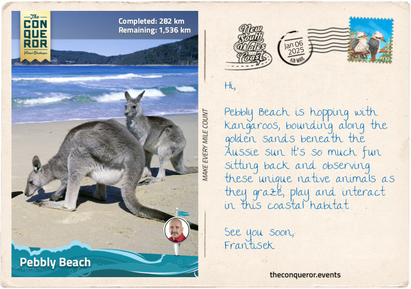
Pebbly Beach
Aside from being a picturesque spot on the coast, a very good reason to visit Pebbly Beach was to enjoy the beach-loving eastern grey kangaroos. Lounging about and grazing on the nearby grassy area, the kangaroos weren’t particularly fussed by the presence of humans, probably because they are accustomed to human visitors on this sheltered beach within the Murramarang National Park.
Eastern grey kangaroos are the second largest and heaviest marsupials native to Australia. They are usually found in the eastern third of the country, from the northernmost point of Queensland down to a few parts of Tasmania. One fascinating fact about these mammals is that they are very good swimmers, hence very comfortable hanging around Pebbly Beach. They will take to water to evade predators and then attempt to lure them in. If they succeed, the predator swiftly becomes the prey because the kangaroo will hold its head underwater until it drowns. The strong muscular body, hind legs and powerful tail are not to be trifled with, even when they seem docile and tolerant of people. Interaction in the wild is best done at a distance, but if an opportunity arises in a safe environment to touch their soft coat, know that it is a wonderful experience only surpassed by seeing a joey pop out from the mum’s pouch to check out the surroundings before tucking itself away and out of view.
Murramarang National Park stretches along the coast for 27mi (44km) and is one of the rare places where spotted gums, endemic trees to eastern Australia, grow all the way down to the ocean. Spotted gums are a small group of eucalypts, and it is a fascinating study as their smooth, mottled bark peels away in patches. Beneath the bark is a creamy white to grey surface. Run your hands over the smooth trunk next time you get a chance. Because the bark grows back at different rates, the trunk gets a colourful spotted pattern that can create a beautiful abstract image when photographed.
“Old Blotchy” is a well-known tree to locals near Temeil because it is supposedly the oldest surviving spotted gum, estimated at 400 years old. Having been around so long, its girth measures 36ft (11m), is 193ft (59m) high and, as such, made it into the National Register of Big Trees. While its crown is a fair way up the trunk, it is interesting that some of its limbs have grafted together, creating fascinating twists and knots along its branches, a phenomenon known as limb inosculation.
km od začátku : 0410
Hyams Beach
After admiring the sheer size of ‘Old Botchy’ and feeling somewhat small-sized in comparison, I made a beeline for Booderee National Park in Jervis Bay, which has a unique status as a territory on its own.
Jervis Bay has a governance structure separate from New South Wales and is strategically important as a deep-water port and naval base. The Australian Navy's HMAS Creswell, located near Jervis Bay Village, serves as a training facility and plays a vital role in the country's defense capabilities.
Within its territory and at the heart of Booderee lies its botanical jewel, the Booderee Botanic Gardens, the only Aboriginal-owned botanic garden in Australia. The site was originally a farm owned by piano manufacturer Octavius Beale, aimed at growing timber for piano frames, but the plantation failed. In the mid-20th century, the Australian National Botanic Gardens developed it as a botanic garden until 1995, when it became independent, and the local Koori community became its owners. The gardens are spread over 80 hectares and focused on the Aboriginal use of plants for bush food and medicine.
The park's name means 'bay of plenty' in the Dhurga language, and it is home to more than 450 species of native plants, including beauties like Eucalyptus summer red, a flowering gum tree with gorgeous pinkish-red flowers that are rich in nectar, thereby attracting bees and nectar-loving birds like New Holland honeyeater. Another interesting-looking plant is the Kangaroo tail, a grass tree with a tall, dark, spear-like central trunk covered in tiny, densely packed white flowers that produce sweet nectar. Indigenous Australians soaked the flower in water to make a sweet drink, and the resin exuded from the flower’s spide was used as an adhesive to make tools and as lacquer for furniture.
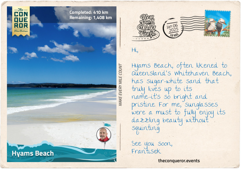
Aside from the village and the territory’s defence role, Jervis Bay is also an oceanic bay that is incredibly beautiful with its white sands and turquoise waters. Just a stone's throw away from Booderee, back in NSW, lies Hyams Beach, a spot of paradise renowned for its pristine white sand.
I took a short walk behind the beach, on a trail through coastal forest and sand dunes, to do a little more birdwatching. I kept my eyes peeled for the colourful crimson rosellas and the eastern spinebills, which were a little harder to find since they were only 6in (15cm) long. Once finished, I returned to the village via the beach and enjoyed listening to the squeakiness of the sand beneath my feet.
km od začátku : 0465
Nowra
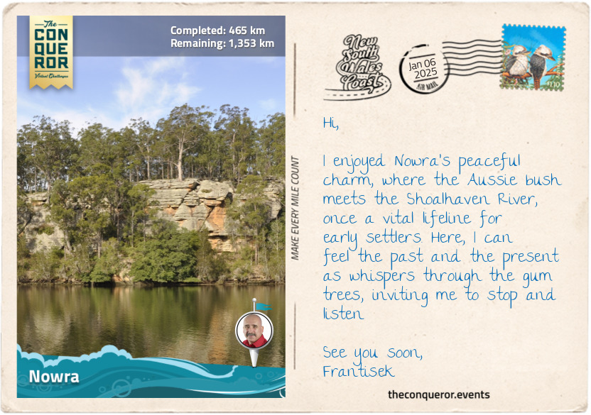
Leaving the coastal area, I followed the Shoalhaven River inland to Nowra, the regional hub for the Shoalhaven district. Nowra was settled by Europeans in 1857, with dairy farming and timber as the main industries. Prior to settlement, Nowra was inhabited by the Wodi-Wodi tribe of the Yuin nation, to whom the town’s name meant black cockatoo.
There are several renowned historical figures in and around Nowra, beginning with Mary Reibey, who appears on Australia’s $20 note. Originally born Molly Haydock, Mary was convicted for stealing a horse in England when she was 13 and shipped to Australia in 1792 to serve as a nursemaid. She married at 17 and built a successful enterprise across various industries with her husband. Mary applied for a land grant in the early 1800s in Burrier, west of Nowra, where her descendants continue to live. Highly respected for her charitable works, Mary’s property in Macquarie Place, Sydney, was the founding location for the Bank of NSW.
On the northern banks of the Shoalhaven River stands the Bundanon homestead, a double-storey 19th-century sandstone house, once the home of famous artist Arthur Boyd. Purchased in the 1970s and expanded to include a home studio, Boyd painted many Shoalhaven landscapes, capturing the region’s essence. His most significant work is the Great Hall Tapestry in Parliament House, Canberra. Measuring 65ft (20m) long by 30ft (9m) tall, the work features a forest of towering eucalyptus trees from Boyd’s home and pays homage to Australia’s distinctive bush landscape.
Adjoining Bundanon are several other properties, including Eearie Park, once occupied by equally famous artist and Boyd’s brother-in-law, Sir Sidney Nolan, known for his series of 27 paintings depicting bushranger and outlaw Ned Kelly. Another one of his significant works is the 65ft (20m) long mural of the 1854 Eureka Stockade, a miners’ uprising against oppressive mining licences and authority and the struggle for rights and reforms during colonial Australia. A very important event in the country’s history, the painting style was influenced by indigenous Australians’ sandpainting technique using a finger-and-thumb stroke. The artwork hangs in the Reserve Bank of Australia’s Melbourne office.
The last famous figure from the area is a Thoroughbred racehorse named Archer. One of the year's biggest events is the Melbourne Cup, where the city itself comes to a standstill as people flock to Flemington Racecourse not just for the race itself but also for the vibrant atmosphere, fashion, socialising, and celebrations accompanying this iconic event. Anyway, Archer was a reddish-brown stallion who arrived in 1860 at Nowra to be trained by Etienne de Mestre. A year later, Archer entered the inaugural 2mi (3km) Melbourne Cup. Neither Archer nor Etienne, as the trainer, was favoured at the races until Archer took first place, winning the very first Melbourne Cup. He won it once again in 1862. Archer has had 8 major wins in his racing career and, in 2017, was inaugurated in the Australian Racing Hall of Fame, while Etienne was added in 2002.
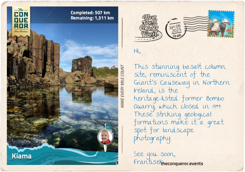
km od začátku : 0507
Kiama
Entering the Illawarra region, I headed to Kiama to check out its two blowholes. Unsurprisingly, the word Kiama is derived from the Aboriginal word ‘kiarama’, meaning ‘place where the sea makes a noise’, which refers to the blowholes.
Before European settlement, the land was occupied by the Wodi Wodi people. Evidence of midden shells, an accumulation of discarded shells, is found near Bass Point, indicating indigenous settlement from more than 17,000 years ago. Once the Europeans arrived in the 1800s, the area was initially used for wheat farming because of the nutrient-rich volcanic soil and abundance of rain. However, it was unsuccessful, and the community switched to dairy farming. The Kiama Pioneer Butter Factory was the first Australian factory to successfully send butter to Great Britain for consumption instead of to make soap. The factory was also the first to use cream separators to ensure consistent fat content and efficient dairy production.
By the early 20th century, the town was booming, quarrying basalt for road paving and railway ballast and developing a harbour for steamships to transport blue metal stone to Sydney for construction. A highlight of this booming era can be seen through the row of wooden terraces along Collins Street. The weatherboard houses, featuring gabled iron roofs, small-paned windows and simple verandahs, were built in the late 1870s as quarry workers’ cottages. Among them were properties that served as an inn and the town’s post office. Following the Depression Era and World War 2, the quarries closed, and the houses fell into disrepair, being threatened with destruction. Fortunately, a local company saw their potential and saved the properties. They were restored and converted into shops, although a few are used as private homes, that continue to grace the street today. In the 1980s, they were protected by being added to the National Trust of Australia register.
Leaving history behind, I walked past the Kiama Lighthouse and down to a lookout platform where the largest blowhole in the world was putting on a show, spewing water as high as 98ft (30m) up in the air from an 8ft (2.5m) opening. Next, I followed the coastal trail to yet another rock pool, where I took the opportunity to relax and take a refreshing dip.
km od začátku : 0555
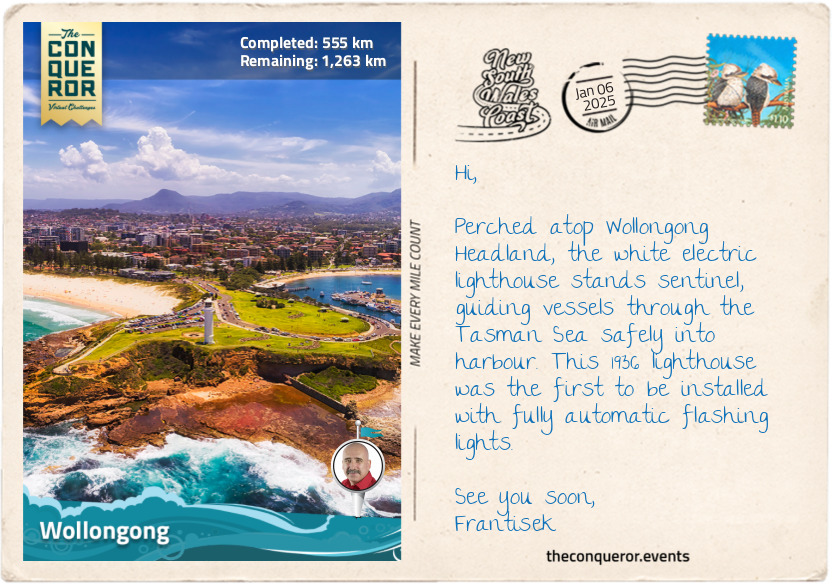
Wollongong
The further north I headed, the more I realised how much closer I was getting to Sydney and its urban expanse. Only 50mi (80km) south of Sydney, I arrived in Wollongong, the state’s third-largest city and Australia’s tenth-largest. Nestled between the rugged Illawarra Escarpment and the Pacific Ocean, Wollongong was first occupied by the Dharawal people. The name "Wollongong" is derived from an Aboriginal word meaning "sound of the sea" or "ground near water”.
George Bass, an explorer and surgeon, and Matthew Flinders, a navigator and cartographer, both with the British Royal Navy, were the first people to explore the southeastern coast of Australia, more specifically, their 1796 expedition navigating and charting parts of the coastline around present-day Wollongong. Their insight into the Illawarra region helped with its development and opened up the area for eventual colonisation.
Coal mining and steel industry accelerated the city’s development in the late 19th and early 20th centuries. Throughout the 1900s, the city's economy continued to evolve in the healthcare, tourism and education sectors. Most notable was the establishment of the University of Wollongong in 1951, which grew into a well-regarded educational and research institution in information technology, engineering and environmental sciences.
One of the major community highlights in Wollongong is the annual Illawarra Folk Festival held at the Bulli Showground each January. Launched in 1985 as an opportunity to celebrate folk music and dance, the festival has grown to a four-day extravaganza, attracting thousands of attendees to join in the community spirit, attend workshops, and interact with artists while enjoying an international lineup of a wide range of folk music genres. Close to 100 artists put on a show, be it singing, poetry readings, yarn spinning (‘yarn’ is Aussie slang for telling tales), indigenous performances and even circus gigs.
A little southwest of Wollongong in the suburb of Berkeley is Fo Guang Sha Nan Tien Temple, the largest Buddhist temple in the Southern Hemisphere. Set amidst a sprawling landscape, the temple complex features the Nan Tien Institute, an accredited educational centre focused on Buddhist studies, meditation and retreat lodgings, a beautiful 8-storey pagoda with curved eaves, and a pond densely filled with blooming lotuses. The centrepiece of Nan Tien Temple is its magnificent main shrine hall, adorned with intricate traditional Chinese architectural elements, ornate decorations, and thousands of small Buddhist statues on the walls.
As I usually enjoy finishing my day’s journey near the ocean, I wandered to Wollongong Head, from where I could explore a few more landmarks, including two lighthouses, the only ones on Australia’s east coast to be so close to each other, the heritage-listed harbour precinct, and three 68-pounder guns, now defunct, from the former military Flagstaff Hill Fort.
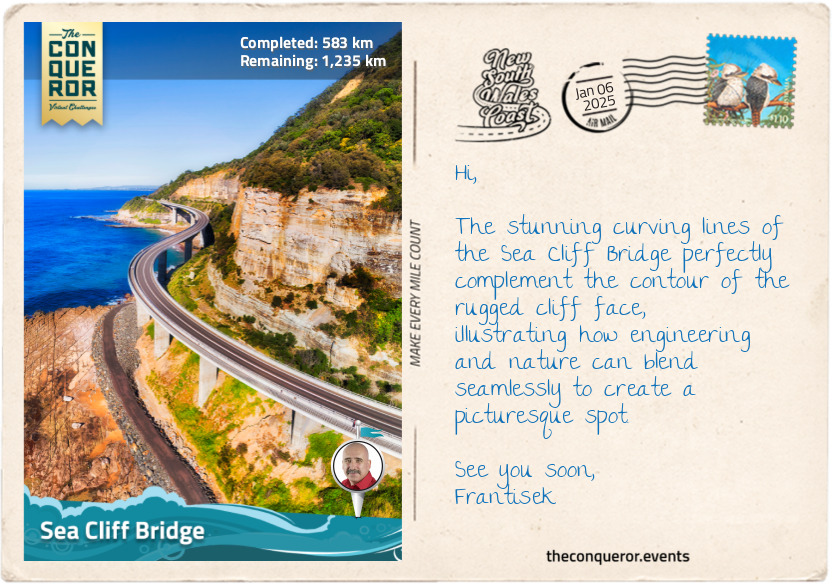
km od začátku : 0583
Sea Cliff Bridge
I always marvel at the engineering feat of building any kind of bridge, including its design, functionality, and the complexity of connecting two landmasses. Structures like the Navajo Bridge in the Grand Canyon, 476ft (145m) above the Colorado River, or what seems like a rickety suspension bridge when crossing Hillary Bridge in Nepal on the way to Everest Base Camp, but find that it is sturdy with dazzling views over Dudh Koshi River, or the mind-boggling 22mi (35.7km) long Hangzhou Bay Bridge in China built to shorten the highway route between two cities, never cease to amaze me.
Then there are the architectural beauties around the world like the UNESCO-listed cantilever Firth Bridge in Scotland, carrying 200 trains per day, the famous suspension Golden Gate Bridge in San Francisco that’s featured in more movies than any other bridge in the world, or the cable-stayed pedestrian Helix Bridge in Singapore inspired by the double helix of DNA.
The commonality of all these bridges is the need to cross some form of waterway. However, there are instances where a bridge must navigate around a cliff face while maintaining a safe distance to avoid falling rocks. The Sea Cliff Bridge between the small coastal towns of Clifton and Coalcliff is one such example.
The section between Clifton and Coalcliff was originally serviced by the Lawrence Hargrave Drive, a scenic road regularly prone to rock falls, erosion and mudslides, especially after high rainfall. When a large embankment slip caused the road's closure in 2003, restricting access between towns and large centres like Wollongong, the local community strongly protested and an alternate plan was developed.
Building the bridge was a complex task. Engineers conducted detailed geological studies to deal with falling rocks. They also needed to protect the coastal environment, ensuring marine and land habitats were not harmed. Specific design methods were chosen so the bridge could withstand strong winds and saltwater conditions. Furthermore, the steep and rough terrain made construction difficult, requiring special techniques and equipment.
The result was a 2185ft (665m) long curving bridge around the contour of the cliff face, 135ft (41m) at its highest point. It opened in 2005 with two lanes, shoulders on either side and a pedestrian walkway. The bridge’s lifespan is estimated at 100 years.
Experiencing this engineering marvel on foot was a must. I strolled across the bridge, taking my time, absorbing the vastness of the Pacific Ocean to one side and the dramatically rising cliff face on the other. I almost felt suspended between the ocean and the cliffs. Add a sunny day to this, and the experience was pure bliss.
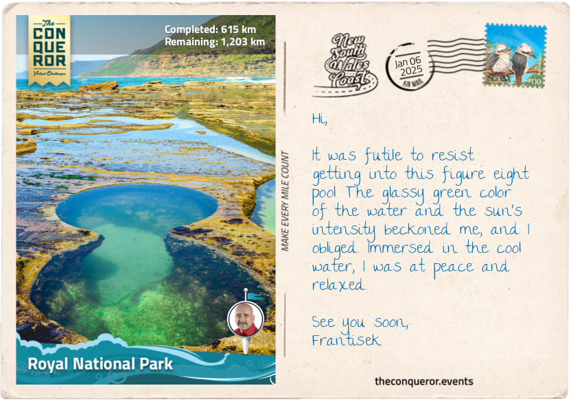
km od začátku : 0615
Royal National Park
Shortly after crossing the Sea Cliff Bridge, I arrived at the southern end of the Royal National Park. Inaugurated in 1879, it is Australia’s first national park and the world’s second oldest after Yellowstone in the United States. Originally known only as National Park, in 1955, it was renamed after Queen Elizabeth II passed by in a train on her Australian tour.
I started with the Coastal Track, excited to explore the rugged cliffs and native bushland. My first destination was the Figure Eight Pools at the base of the cliffs, which required quite a bit of backtracking to get to it but was worth the effort. As the name suggests, the pools, carved out of the relentless pounding of the waves, were indeed in the shape of the number 8. The water was crystal clear. Tempted, I stepped in for a refreshing dip.
I carried on, sometimes above the cliffs, sometimes at sea level on a beach, until I reached Eagle Rock, a fabulous rock formation jutting out into thin air, which, when seen from a certain angle, indeed resembled an eagle’s head. Nearby, the Curracurrong Falls plunged 328ft (100m) into the ocean below.
The track followed close enough to the cliff’s edge, giving me the most incredible panoramic views of the ocean and the shrub-covered landscape. As I marvelled at the sights before me, I stumbled upon Wattamolla Falls, cascading into the emerald-coloured water below. A viewing platform at the top gave me a perfect vantage point to admire its beauty, but I was unable to resist the allure of the falls. I descended to the base, where I indulged in a ‘waterfall shower’, letting the cascading water wash over me in a moment of utter joy.
At Marley, I turned inland for a hike on the Marley Track, a rugged and narrow trail through heathland. It was a solitary and tranquil experience, allowing me to immerse myself fully in the natural surroundings. Along the way, I kept my eyes peeled, hoping to come across the Gymea lily, a magnificent Australian native plant known for its spectacular red flowers and unique appearance.
From Marley Track, I connected with the Winifred Falls Track, which led me through dense forestry of eucalyptus trees and down a steep descent to the pools at the base of the falls. Winifred Falls, though not particularly tall, was quite attractive as the water gently tumbled over an overhanging slab of rock. While resting, I was delighted to spot a sulphur-crested cockatoo. These striking birds, native to Australia, are known for their bright white plumage and distinctive yellow crest, which they raise when alarmed or excited. They are highly intelligent and social birds, often seen in noisy flocks. It was a treat to observe it in its natural habitat.
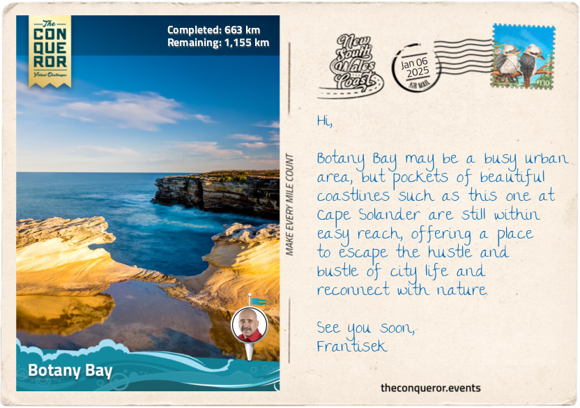
From here, I followed the trail a little further until I reached the suburban outskirts of Sydney, heading toward Botany Bay.
km od začátku : 0663
Botany Bay
Botany Bay (Kamay in Dharawal, the indigenous name) is steeped in the history of Australia’s colonisation days. It is a tale of two eras, where the untouched natural beauty first witnessed by Captain James Cook in 1770 starkly contrasts with today's bustling urban landscape. To appreciate Botany Bay’s evolution from an untamed landscape to an industrial and residential hub, I need to step back in time before I fast forward to the present day.
Let’s take a look at Botany Bay in 1770. Imagine standing on the deck of the HMS Endeavour as it approached the pristine shores of Botany Bay in April 1770. Captain James Cook and his crew were the first Europeans to set foot on the land. They were greeted by a landscape of unspoiled beaches, dense forests, and a cacophony of bird calls. Cook initially named it "Stingray Harbour" due to the abundance of stingrays. It was later renamed "Botanist Bay" and then settled on Botany Bay after the unique plant life catalogued by the ship’s botanists, Joseph Banks (the flower Banksia was named after him) and Daniel Solander.
When Joseph Banks returned to Britain, he became interested in colonisation. He recommended Botany Bay as a suitable site for a penal colony. The First Fleet of 11 ships arrived in January 1788, filled with more than 700 convicts. When Governor Arthur Phillip arrived on his ship HMS Supply, he swiftly concluded that the land was unsuitable due to insufficient fresh water, being too swampy, water too shallow to anchor ships and trees too hard to cut down. The fleet relocated further north in Port Jackson. A year later, Captain John Hunter, who would later succeed Phillip as governor, found Botany Bay suitable and began the area's settlement.
Now, let’s fast forward to the present day, where Sydney Airport’s runways extend into the bay. The skyline is dominated by the towering cranes and container ships of Port Botany, one of Australia’s largest and busiest ports. The untouched shores are long gone, though the sandy beaches are still present, albeit dotted with pathways and recreational facilities.
The dense forests that once lined the bay have largely given way to urban development. Patches of green remain in the form of protected parks and reserves, such as Botany Bay National Park, preserving some of the nature that Cook saw more than 250 years ago. The birds that flitted in the eucalyptus forests are still around, perhaps not as many or as diverse. However, the unmistakable screeching sound of the cockatoos or glimpses of vibrant parrots can still be experienced, having adapted to the urban environment.
Throughout Botany Bay’s history, the Dharawal people have been the Traditional Owners of the land, having lived here for thousands of years. Today, the Dharawal people continue to contribute to the identity and care of Botany Bay, ensuring their legacy continues and their traditions and stories are preserved.
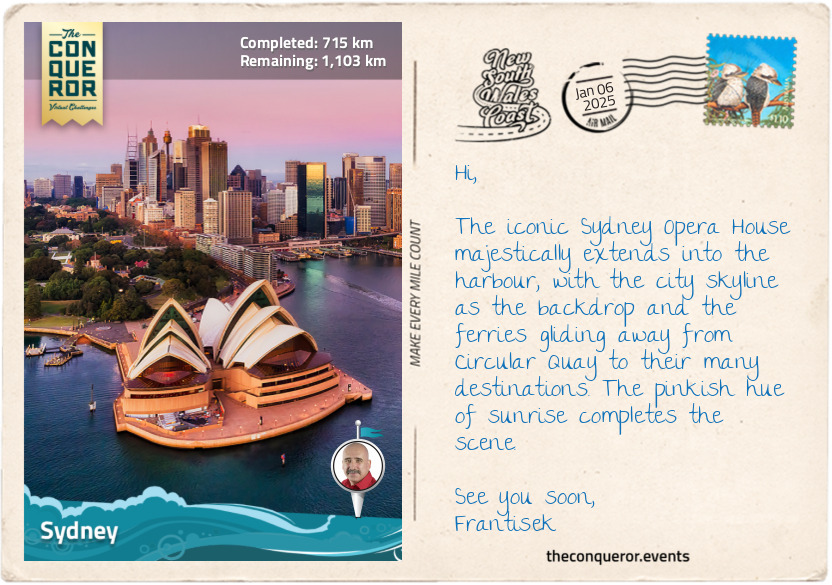
km od začátku : 0715
Sydney
There is no greater cosmopolitan location on the NSW Coast journey than the state’s capital, Sydney. As the largest and most iconic Australian city, it is widely known for two of its most famous landmarks, the Sydney Opera House and Sydney Harbour Bridge.
Sydney is a complex landscape, given its extensive waterways and varied topography. It is a sprawling urban area with the Pacific Ocean to its east, national parks to its north and south and stretching west all the way to the Blue Mountains. The Paramatta River cuts through the landscape as a major tributary of Sydney Harbour (also known as Port Jackson). The natural harbour is one of the largest and most picturesque in the world.
Bridges and tunnels connect various parts of the city for vehicular transportation, while water taxis and a network of ferries connect commuters from their suburban homes to downtown. Catching one of the commuter ferries from Circular Quay is a great and economical way to explore Sydney and visit attractions like Taronga Zoo or its prettier suburbs, like Manly or Watson Bay.
With so much water surrounding the city, it is expected that it will have an endless supply of gorgeous beaches, from the famous Bondi Beach with its vibrant beachfront scene to Manly Beach, known for its laid-back atmosphere, Coogee Beach, popular with families and Palm Beach, where the long-running TV show “Home and Away” is filmed.
There are so many points of interest in a very contained space that it would require an independent journey to Sydney alone to cover its extensive history from early colonisation to the financial and commercial hub it is today. But a roundup of some highlights would include exploring The Rocks, Sydney's oldest neighbourhood steeped in colonial history, marvelling at the architectural wonder of the Sydney Opera House, and for the courageous, climbing Sydney Harbour Bridge to take in the views from the top. My favourite activity is a wander around Darling Harbour to visit the elegant Chinese Gardens and check out the historic vessels at the Maritime Museum, particularly the tall ship James Craig.
The city’s business centre juxtaposes historic buildings and modern skyscrapers. The Queen Victoria Building is a stunning example of Victorian architecture, housing boutique shops and cafes, contrasted by the sleek, glassy facades of the commercial buildings, upscale restaurants and luxury boutiques in the Barangaroo precinct.
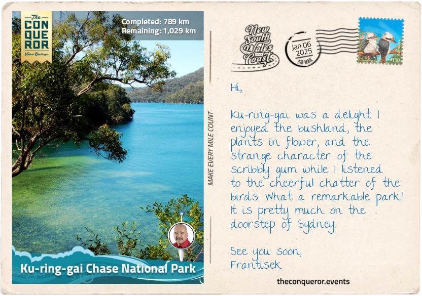
Much as I wished to continue exploring Sydney, the rest of the coast awaited, so I pushed on to my next destination, Ku-ring-gai Chase National Park.
km od začátku : 0789
Ku-ring-gai Chase National Park
While not completely out of Sydney, I am, however, on its outskirts, visiting the third oldest Australian national park. Established in 1894, Ku-ring-gai Chase National Park is beautifully located south of the Hawkesbury River. The park is a wonderful display of untouched bushland, sheltered coves, and sparkling blue water views.
Ku-ring-gai’s plant life is quite diverse, with more than 1000 species recorded. It features low, shrubby heathland, eucalypt trees such as Sydney peppermint and red bloodwood, whose sap was used in traditional medicine to heal open wounds, burns and sores. The small area of rainforest includes the dense, glossy-leaved Lilly Pilly, an evergreen tree with pink summer flowers and edible winter fruit. The fruit varies from tart to sweet, and its high acid content makes it a perfect candidate for homemade jams or preserves.
A quirky eucalypt tree found in the park is the scribbly gum, so-called because of the scribbles found on its smooth trunk made by moth larvae. The moth grub tunnels between the old and new bark, and as the old bark sheds, the new marks appear. The trunk of the tree was often used by Aboriginal people to make coolamons (vessels) or, in Wiradjuri, known as guliman. The coolamons were vessels used to carry water or collect bush tucker, like fruit and nuts. Cuts were typically made on the south side to minimise stress on the tree, as evidenced by the scars on the tree. The tree's usefulness extends further by providing a home in its hollows and nectar from its flowers to possums, flying foxes, owls and parrots.
There is no shortage of wildlife in the park, but many are shy, nocturnal creatures like possums, gliders, bandicoots and swamp wallabies. Then there’s the common bent-wing bat that managed to colonise itself over the last 15,000 years from southern Europe to Asia, Africa and all the way south to Australia. More than 100 species of butterflies inhabit the park, with beauties like the Delias nigrina (common Jezebel) with white and black-tipped topside and a black, yellow and red underside.
The park is on the traditional lands of the Guringai Nation, from which the name is taken. A very important place is the Red Hands Cave at the park's northern tip. It provides physical evidence of their ancestors through a red handprint on the rock, engravings in the soft sandstone on the ground by the Garigal people of the Gurangai Nation, and a spiritual connection to their past.
Ku-rang-gai was vast, with many tracks through the bush, some leading to secluded beaches or expansive views of the central coast. From the highest point on the Willunga Track, the outline of Sydney and the suburb of Chatswood was visible to the south.
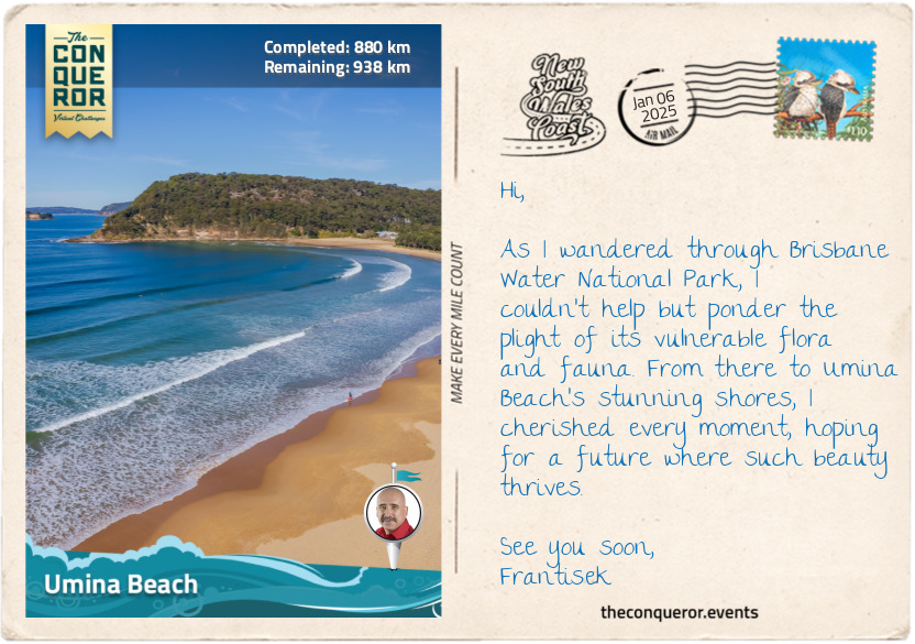
km od začátku : 0880
Umina Beach
Soon after leaving Ku-ring-gai National Park, I arrived at the Peats Ferry Bridge. Opened in 1945, it connected Sydney to the Central Coast until 1973, when the adjacent Hawkesbury River Bridge replaced it as part of the Pacific Motorway (M1). The bridges span the Hawkesbury River, a 75mi (120km) long tributary that, together with the Nepean River, nearly encircles Sydney’s metro region. The Hawkesbury River is a water lover’s haven with deep gorges and lush, forested banks – allowing anything from boating, fishing, and kayaking.
Not far from the bridge is the Brisbane Water National Park (est. 1959), containing several rare and endangered flora. The Grevillea shiressii is a vulnerable plant species with clusters of flowers that start green, turn blue-grey and then become a translucent cream. It is endemic to NSW, found only in the park’s surrounding area. Several other vulnerable plants exist, such as Camfield’s stringybark, Somersby mintbush with pale mauve flowers and Thick-leaf Star-hair. One flower that was thought to be extinct, the Donkey Orchid, so-named because of its ear-like petals, has reappeared.
In addition to its flora, the park is also a sanctuary for rare and endangered fauna, such as the nocturnal squirrel glider that likes the hollows of Acacia trees and Banksia shrubs; the spotted-tail quoll, the second-largest carnivorous marsupial in the world, after the Tasmania devil; and the cuddly-looking, fluffy-eared koala that is typically found snoozing in a eucalyptus tree or chewing on its leaves.
One of the park's highlights is the Kariong Brook Falls. Off the main track, the waterfall is hidden in dense bushland, but once there, it is a perfect, secluded spot to swim, soak in the atmosphere, and watch it cascade over the cliffside.
Continuing my journey, I passed by Pearl Beach, a quaint coastal village and hiked up to Mount Ettalong Lookout for panoramic views of Broken Bay, Lion Island and my constant companion, the Pacific Ocean stretching before me. I stopped at a picnic table beneath the towering Sydney Red Gums for a snack and captured a few photos for my collection.
As the afternoon sun began to dip, I reached Umina Beach, an ideal coastal town with a long and wide stretch of unspoiled beaches. Umina is known for its excellent surfing conditions, and I watched, seated on the beach, as the surfers effortlessly rode the waves or diligently waited for the next one.
I finished the day at the nearby ferry terminal as I waited to catch a ferry ride across Broken Bay to Wagstaffe on the Bouddi Peninsula.
km od začátku : 0941
Norah Head
From Wagstaffe, I set off towards Norah Head with my first stop at Bouddi National Park, tackling the 5mi (8km) trail from Putty Beach to Macmasters Beach. It was an incredible, rugged track, just like the coastline, with a nice lookout at Gerrin Point. The sea was wild as it smashed against the coastline, showing its powerful force. The trail descended onto the beach at Maitland Bay, named after SS Maitland, a paddle steamer that wrecked offshore in 1898. The park’s boundary extends about 984ft (300m) into the Tasman Sea and is frequented by whales, dolphins, and seals.
Keeping an eye on the sky, I was hoping to see an osprey or sea eagle as I ventured on northbound until I reached The Entrance, a small town where Tuggerah Lake meets the Pacific Ocean through a narrow tidal channel. Pelican feeding is a major attraction, a tradition that started in the late 20th century, and so is fishing, with catches including whiting, bream and flathead.
Next, I circled around Tuggerah Lakes, a wetland system consisting of three interconnected lakes, with Tuggerah Lake being the largest. Interestingly, while all three lakes are quite large, with a combined perimeter of 65mi (105km), none exceed 6.5ft (2m) in depth, making them quite shallow. Because of the shallow water, it has extensive beds of seagrass attracting waterbirds like sharp-tailed sandpipers, chestnut teals and black swans.
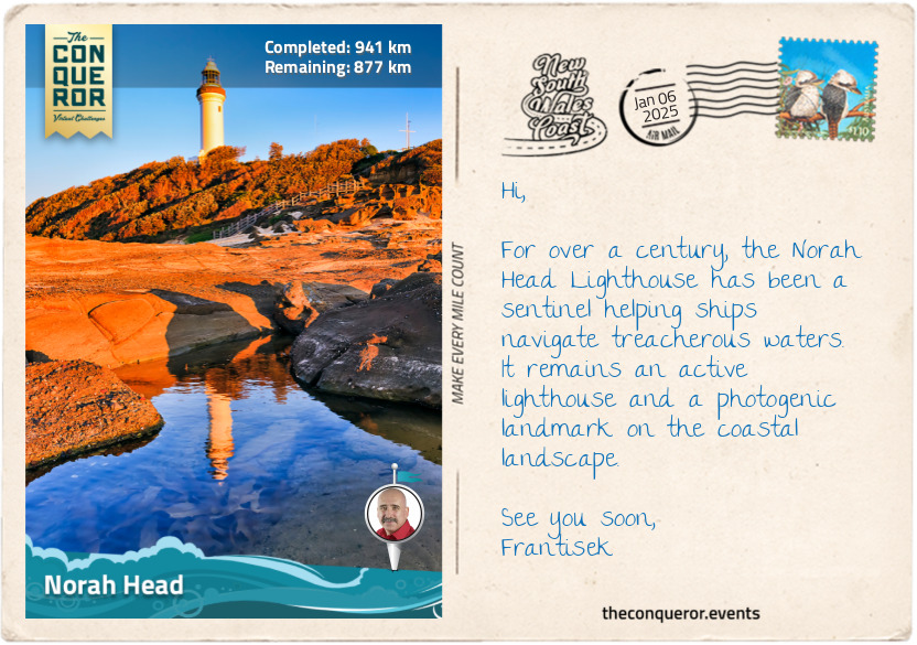
I finished my day’s wanderings at Norah Head, a sleepy coastal village and headland home to the historic 1903 Reflections Norah Head Lighthouse. During World War II, several naval battles occurred near here, resulting in the sinking of the Nimbin in 1940 and the fishing trawler Millimumul in 1941. When the SS Iron Chieftain was sunk by a submarine in 1942 near Manly, NSW, the surviving crew floated on one of the life rafts until they were rescued and reached shore at The Entrance a day later. I found myself at Soldiers Beach, listening to the rhythm of the waves, as I ended another perfect day.
km od začátku : 0985
Lake Macquarie
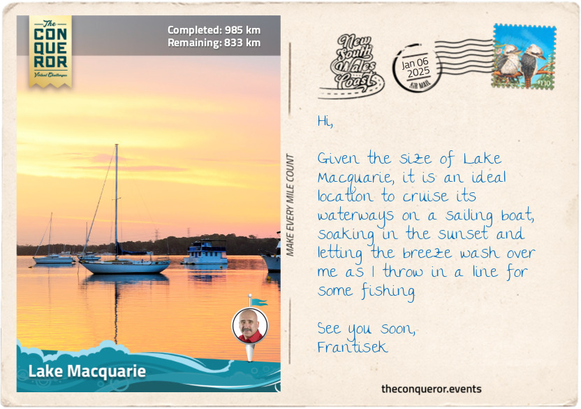
About 6mi (10km) north of Norah Head lies the beginning of the largest coastal saltwater lake in the Southern Hemisphere. With a shoreline stretching about 108mi (174km), Lake Macquarie is part of a larger catchment area that includes rivers and creeks flowing into it. The lake contains several islands, including Pulbah Island, designated a nature reserve and home to goannas. The lake was formed during the last Ice Age when the area was a river valley carved by the flow of a river. As the Ice Age ended and the glaciers melted, sea levels rose, causing the ocean to flood the river valley and transform it into a coastal lake.
As I travelled along a narrow strip of land between the lake and the sea, I arrived at Swansea and the entrance to Lake Macquarie via the narrow Swansea Channel. The area surrounding Lake Macquarie was originally inhabited by the Awabakal people, a strong and determined clan who practiced fire-stick farming (controlled burning) that helped them with hunting and navigating through dense shrubland.
To the east of Swansea is Reids Mistake Head, and east of that is Moon Island. The story of how the headland got its name goes back to 1800 when Captain William Reid was sent to Hunter River, further up north, to obtain a cargo of coal. Reid sailed to Moon Island, thinking it was Nobby’s Head at the mouth of the Hunter River. He loaded his ship with coal and returned to Sydney. It was upon his return that Reid discovered his mistake, having not sailed far enough north and had instead reached another river, the entrance to Lake Macquarie, which happened to be another source of coal.
This area became known as Reid’s Mistake, a name applied to the lake’s entrance and eventually to the whole lake. It wasn’t until 1826 that it was renamed Lake Macquarie, after Governor Lachlan Macquarie, a Scottish officer recognised for his efforts of leading NSW from being a penal colony to a free settlement. And so, Reid’s Mistake remains the official name of the southern headland.
km od začátku : 1030
Worimi National Park
Had Captain Reid sailed up a little further, he would have come across Nobby’s Head. On the other hand, maybe just as well he didn’t because in the same year at Broken Bay a gang of 15 convicts seized the sloop Norfolk and sailed northwards, wrecking it at the entrance to Hunter River. They then seized another boat in nearby Newcastle. They carried on in their attempt to escape, but nine of them were eventually captured. The peninsula near the Norfolk wreck was subsequently named Pirate Point after the convicts’ piratical act. The area seemed prone to piracy as a further seven ships were illegally seized from Newcastle in the first half of the 1800s.
Pirate Point carries a dual name, where the Traditional Owners, the Worimi people, know it as Burrabihngarn. The dual naming convention of geographical features and cultural sites illustrates the NSW Government’s support and recognition of the Aboriginal cultural heritage.
Hopping on a ferry, I sailed across the Hunter River into Stockton, a suburb of Newcastle, to venture down the break wall where the remnant of Adolphe, which sunk in 1904, is still visible, probably because it’s actually resting atop SS Wendouree, wrecked in 1898, SS Lindus in 1899 and somewhere further below is the steamer Colonist wrecked in 1894.
Returning to shore, I walked along Stockton Beach, where, at one time, the 700ft (200m) Norwegian bulk carrier MV Sygna ran aground in 1974 after a heavy storm with swells 56ft (17m) high battered the port entrance. Fortunately, all 30 crew were rescued. When salvage operations commenced, the back unfortunately split in two. While the bow was towed away, the stern settled deeply into the sand and, over decades, slowly decayed while visible from the beach. In 2016, the structure finally collapsed and sunk into the ocean, with only a small section above the waterline.
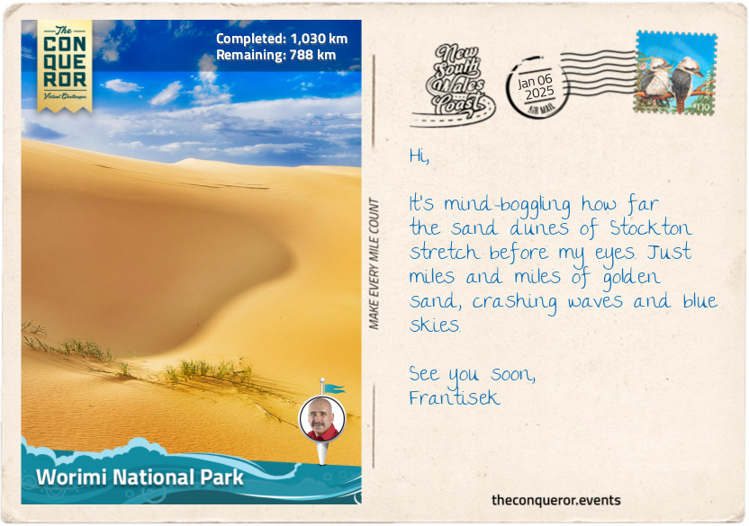
From the beach, I continued along the shore until I reached the Stockton Bight Sand Dunes within the Worimi National Park. It stretches an incredible 20mi (32km) parallel to the park and contains a forest of blackbutt, smooth-barked apple gums and paperbark. The sand dunes are the largest moving coastal dunes in the Southern Hemisphere. This is one place for serious quad biking or 4WD adventuring while tossing in a sandboarding ride or two. For an extra experience, there’s a visit to Tin City, built as a squatter’s village during the 1920s Depression Era. Made up of a bunch of small tin shacks half buried by the shifting sands, the shacks have a post-apocalyptic feel about it, almost like a scene out of a Mad Max movie.
And now, onto Hawks Nest to check out some dolphins.
km od začátku : 1101
Hawks Nest
I swung inland after Stockton to circle around Port Stephens Bay, travelling through several small towns. Karuah is supposedly known for its fresh local oysters, but I didn’t stop to find out even if I would have been partial to a serving of Oysters Kilpatrick topped with crispy bacon bits and Worcestershire sauce.
When I passed through Tea Gardens, all I could think of was sitting outside at a café on a balmy afternoon with a pot of tea and a lamington, an Aussie favourite with various stories of its origins. While there is no conclusive evidence of how it came into existence, one thing is certain: the recipe for the famous lamington was discovered in a 1900 issue of the Queensland Country Life newspaper, making it more than 100 years old and most likely named after the then Governor of Queensland, Lord Lamington. How the town got its name is also a mystery. Some suggest it was after an attempt to grow tea in the 1820s, albeit unsuccessfully, or because of the tea trees along the Myall River near the town.
I arrived in Hawks Nest on the northern shores of Port Stephens Bay, which has a long and colourful story. The bay resulted from a submerged estuary of the Karuah and Myall Rivers. It was initially occupied by the Worimi people, who lived along its shores. Early explorers were attracted to the bay’s clear waters. When Captain James Cook sailed by in 1770 on the Endeavour, he named the bay after his friend Philip Stephens, the Secretary of the Admiralty. The HMS Salamander was part of the Third Fleet, transporting convicts to Sydney, and the first to enter the bay in 1791. Then, in 1795, HMS Providence arrived. The captain was surprised to find five convicts living with the Worimi people, who escaped from the Sydney area but got wrecked in the bay. By the early 1800s, the area was a haven for escaped convicts, and a garrison was established at what is now known as Soldiers Point.
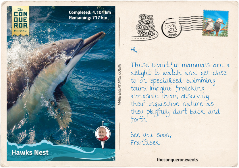
These days, the Port Stephens region is a holiday getaway. Its greatest draw is the resident pod of 150+ bottlenose dolphins, hence the bay’s claim as the “Dolphin Capital of Australia. These magnificent animals are super-intelligent with a hearty appetite, eating up to 22lbs (10kg) of fish per day. They are also ‘conscious’ breathers, unlike humans, who breathe automatically, needing to surface every few minutes to breathe. When asleep, only half of their brain is at rest while the other half is awake to manage breathing and staying alert.
km od začátku : 1159
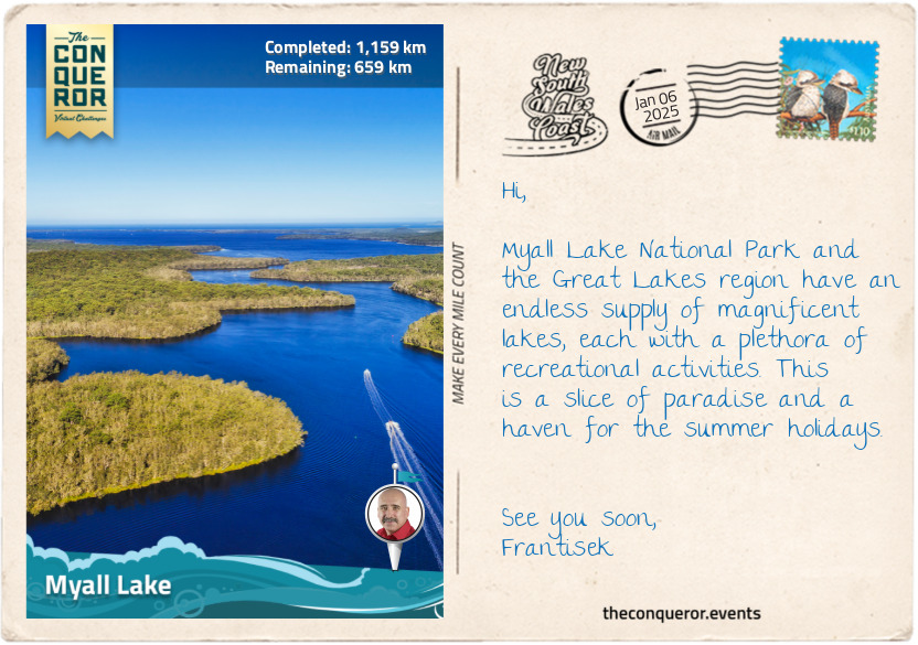
Myall Lake
As I wound along the winding coastal road, I veered inland again, arriving at Bombah Point, the gateway to Myall Lakes National Park. I could smell the now-familiar scent of eucalyptus and looked forward to exploring a series of lakes within the park and extending further into the Great Lakes region.
Within the park are a series of interconnected freshwater lakes – Bombah Broadwater, Boolambayte Lake, and Myall Lake. As the lakes are connected, this was a fabulous opportunity to explore them on a small boat, meandering from one to the other. When I reached Myall Lake, the largest of the three, I found the water to be tannin-coloured, a result of decomposed plant material from the surrounding wetlands. Despite its tea-like colour, I was compelled to hop in for a refreshing dip. The water was calm and crisp on my skin.
The shore was lined with native shrubs and trees, such as the paperbark trees with their distinctive peeling bark, thriving in wetland areas, and the Casuarina trees, also known as she-oaks, with their needle-like foliage and sturdy trunks, which help prevent erosion by stabilising the soil. A favourite flowering shrub is the Banksia because of its hardy cone-like flowering, appearing in varying shades from brown and red to orange and gold.
Myall Lake is also part of the Great Lakes region due to its proximity to Smith Lake, separated by a narrow piece of land, and Wallis Lake, the largest of the three. With so many waterways, it’s not surprising that fishing is a significant pastime in the area. A line can be thrown in from the beach, a lake or a river and may be lucky enough to catch bream, whiting, Australian salmon or mullet. While waiting for the fish to hook, sit back, relax, and look out for the birds occupying the wetlands. One example is the brolga, a huge bird from the crane family with a wingspan of up to 7.5ft (2.2m). They are easily recognised by the band of red skin atop their small head. They are also known for their unusual ritual dance when searching for a mate. Cultures like China have stylised these moves to incorporate them into their kung fu martial arts (think of the crane kick in the 1984 Karate Kid movie). Closer to home, the Aboriginal people have incorporated it into their own dance rituals. Sydney-based author Rod Clement was inspired to illustrate and write the children’s book Olga the Brolga, telling the story of a keen bird just wanting to dance.
The best place to finish my exploration was in the twin towns of Forster and Tuncurry at the end of the Great Lakes. Looking for a place to eat, I settled on another Aussie favourite, the chicken parmigiana. If you haven’t had one, it’s a must-try. It’s a chicken schnitzel topped with tomato sauce and melted cheese and served with a good dose of hot chips.
km od začátku : 1231
Native Flora
Australia has a very harsh and unforgiving climate. Just consider the vast expanse of desert outback to the lush coastal regions. For plants to survive in these environments, they need to be tough and adaptable, and over thousands of years, they have found a way to evolve and thrive. The result is a unique and diverse range of flora, of which I will cover three well-known species.
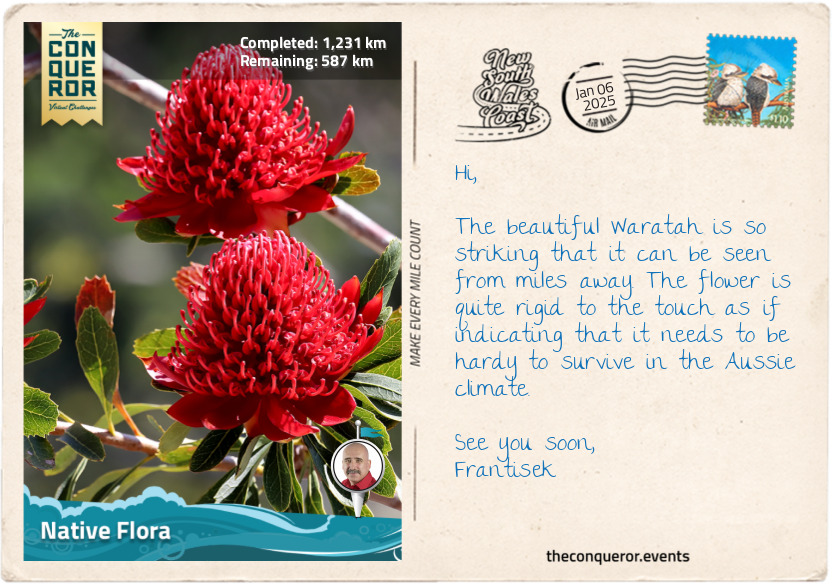
The first one is the Waratah, a striking native plant endemic to and, since 1962, the floral emblem of NSW. The plant features large, vibrant red flower heads made up of many small individual flowers densely packed together, measuring about 4in (10cm) in diameter. Growing up to 13 feet (4m) high, the Waratah thrives in moist, well-drained soils of forests, woodlands, and heathlands, particularly in regions with higher rainfall, such as the Blue Mountains and Sydney. Waratahs provide essential habitat and food to wildlife, attracting nectar-feeding birds like honeyeaters. However, this gorgeous plant doesn’t do well in a competitive environment with dense undergrowth. They do much better in dappled sunlight, preferably beneath eucalypt trees and with plenty of open space.
One of the strangest-looking plants and one that warrants a closer inspection is the Kangaroo Paw. Originally native to Western Australia, it is now found all over Australia and even in the Singaporean Botanical Gardens. The flower on this plant has a paw-like tubular shape. It comes in various colours, ranging from deep crimson to scarlet, pale lemon to golden or soft peach to intense tangerine. Less prevalent are the green tones, often tinged with yellow or red.
Quintessentially Australian and the national flower, the Wattle, when in bloom, is a beautiful splash of bright yellow fuzzy flowers bursting into colour each spring and lasting for several weeks. Besides being an important Australian symbol, the plant is believed to help improve soil by absorbing nitrogen from the air and releasing it as nutrients through its roots. The plant was also used as bush tucker by grinding the wattleseed into flour for damper, but these days, it can be found in a range of foods like muffins, teas or coffee substitutes.
Other interesting native plants are Billy buttons, with bright yellow globe-shaped flowers growing on long stems and the Bottlebrush, named for its cylindrical flower spikes resembling a bottlebrush in shades of red, mauves, yellow and green.
km od začátku : 1296
Native Birds
State emblems, such as the Waratah as the floral emblem for NSW, encourage regional pride and identity while raising awareness about native species and conservation. They serve as representations of a state’s unique characteristics. As such, NSW has three distinct animal emblems: the kookaburra, the platypus and the eastern blue groper.
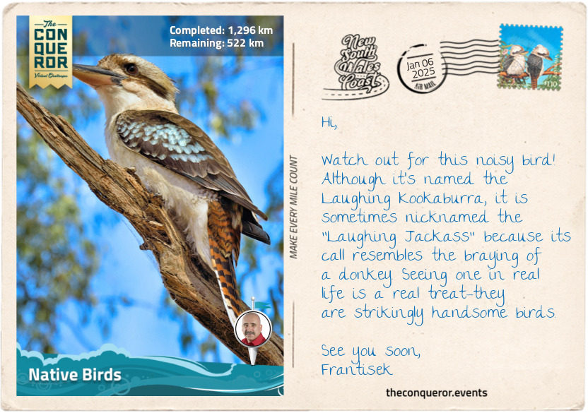
The laughing kookaburra is the state’s bird emblem. It is one of ten kingfishers in Australia and the largest in the world. This iconic Aussie bird is known for its distinctive, laughter-like call, often heard at dawn and dusk. They play an important role in Aboriginal folklore, symbolising joy and the voice of the forest. The kookaburra is recognised by its sturdy body, and the brown and white plumage helps it blend into the environment. They live in eucalypt forests but are adapted to urban areas. Although not necessarily welcomed in the suburbs, given their fiendish laughter, they can wake any person from a deep slumber, hence their “bushman’s clock” nickname.
The platypus has to be one of the strangest-looking animals on the planet. This duck-billed, otter-footed, beaver-tailed mammal seems to have an identity crisis. Its uniqueness also extends to being one of two mammals that lays eggs – the echidna is the other. A nocturnal animal, the platypus is an agile swimmer that eats nearly its own weight in food a day and is a little dangerous if provoked. The male has a spur on its hind legs that can deliver a painful venom. Although not lethal to humans, it does cause severe pain and swelling. Usually, though, they are shy and avoid human interaction.
NSW was the first to have a fish as a state emblem, selecting the eastern blue groper. The fish is native to the coastal waters of eastern Australia. It was once an endangered species due to overfishing, but legislative changes and protection of the species allowed it to recover, and it is currently classified as near-threatened. The groper has a robust body, large scales, and powerful jaws used to feed on crustaceans, mollusks, and other hard-shelled invertebrates. They are born females until they reach 20in (50cm) when they transition to males. Adult males are easily recognised by their cobalt blue colour, while females and juveniles are typically golden to greenish-brown. Extremely territorial, they inhabit rocky reefs, often seen around kelp beds and underwater caves. Friendly and curious, gropers are popular with divers and snorkelers.
km od začátku : 1349
Port Macquarie
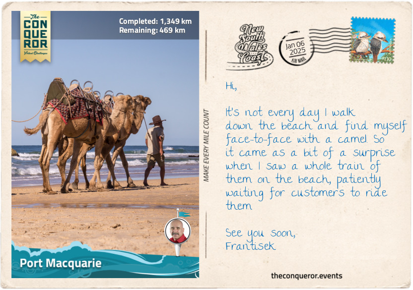
Beautifully located on Hastings River’s south side, Port Macquarie, a once sleepy haven, is now a popular holiday getaway. I can’t blame it given its extensive beaches, each connecting to the next. I figured the best way to experience it was by taking a leisurely stroll along the entire length of the city’s coastline.
But before I could set foot on the sandy shores, my attention was caught by a group of camels led by their handlers. Approaching them for a closer look, I couldn’t help but notice the nonchalant air about them. One of them, a towering creature with a sandy-coloured coat, crouched on all fours carrying a somewhat bored expression, its lips moving rhythmically, chewing on a mouthful of dry grass before spitting out a wad of cud with remarkable accuracy, all the while batting those long eyelashes. As I passed the caravan of camels, their presence seemed almost at odds against the backdrop of the Australian landscape. Yet, I recalled they were introduced to Australia in the 1840s and played an important role in exploring the continent's vast interior. When they were no longer needed for transportation, the camels were released into the wild, and more than a million feral camels occupied the Northern Territory, wreaking havoc on native vegetation.
As I contemplated the conflict presented by the camels with the Aussie landscape, I continued my journey following the sandy expanse of Lighthouse Beach until I reached the historic Tacking Point Lighthouse. Before its construction in 1879, the area had very few lighthouses, and shipwrecks were a common sight. One of the earliest was the 1823 wreck of the schooner Black Jack, privately owned but used by the colonial government when it ran aground due to pilot error. The owner petitioned for compensation and received the schooner Isabella, which unfortunately was seized by convicts in Port Macquarie, who promptly escaped.
I wound around the lighthouse trail through dense coastal scrub and fragrant eucalyptus forests. Along the way, I encountered a wooden boardwalk in the Sea Acres Rainforest, where the path was elevated 23ft (7m) above the forest floor, and enjoyed the bird’s eye view of the canopy. The rainforest was an important resource for the Birpai people, who used the python tree, the second hardest wood in the world, to make weapons and forage for bush food. With each step, I watched for signs of wildlife, hoping to glimpse the elusive goannas that prowled among the underbrush. But the promise of encountering the scarlet robin, with its vibrant red breast and striking black and white plumage, truly piqued my interest.
Pressing onward, I passed Nobby's Beach and Flynns Beach, where novice surfers braved the waves. Then, I took the steep path down to the isolated and pebbly Rocky Beach before finishing at Town Beach, located next to the city centre.
As dusk descended on the town, I grabbed a bag of piping hot fish and chips, with their favourite accompaniments: potato cake and dim sim. I savoured these simple pleasures as I watched the last vestiges of daylight fade into the night.
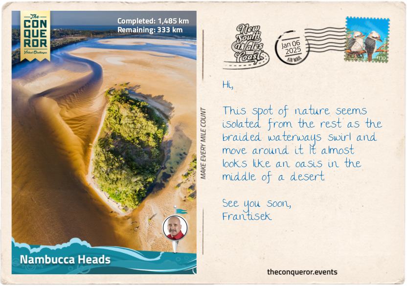
km od začátku : 1485
Nambucca Heads
Long before the Europeans arrived, the small coastal town of Nambucca Heads was the proud homeland of the Gumbaynggirr people. At least a thousand strong, the Gumbaynggirr spoke a common language, passed down through generations, and celebrated initiations that marked the transition from youth to adulthood. Their stories echoed across the valleys and hills.
Yet, loyalty ran deeper than mere tradition. Each clan was fiercely loyal to its own “jagun” (homeland). The Bagabaga lived near the Nambucca River, the Baanbay thrived atop the high plateaus of the Great Dividing Ranges, while the Wiigulga people flourished further north on the Clarence River. Each clan guarded its sacred paths and passed on their dreaming stories only to those who belonged or were kin to each place. The women, strong and resilient, married outside their own clans but within the Gumbaynggirr tribe. Through these unions, the land itself became a living tapestry, binding the clans together through stories and traditions.
The Nambucca Heads Surf Club is one of the oldest in Australia, but it is much more famously known for establishing the Nippers program, a junior lifesaving program for ages 5-13. Australia is surrounded by rugged coastlines, strong rips and surf, and this program helps kids learn how to read surf conditions, how to escape rips, and beach safety while participating in a variety of fun activities that build the necessary skill sets. The program, launched in 1961, was a roaring success that spread out to all the surf clubs around the country, and more than 60,000 children participate every summer. The Coogee Surf Club (near Sydney) has the biggest turnout, with more than 1000 children hitting the sand and surfing every Sunday morning.
There are three viewing platforms around the headland, all with spectacular views of the ocean and a number of waterfront walks. The Lions Riverfront Walk was particularly interesting, as it led to the “Graffiti Gallery”, where the breakwater wall made up of a series of large boulders has been painted with artworks by local artists. This third-of-a-mile (500m) stretch of art features poems, professional and amateur paintings, and great pieces of graffiti. It makes walking the path a visual delight.
Another incredible piece of art is the mosaic wall that wraps around a corner street stretching 196ft (60m). Mosaic artist Guy Crosley scoured the local area for unique pieces of pottery, tiles, china and any other interesting pieces that could be used on the project. He engaged volunteers to help with the project, which took four years to complete. The sculpture features marine animals, mythical creatures, waves and a great octopus gobbling everything up in its path.
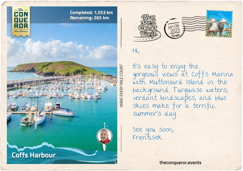
km od začátku : 1553
Coffs Harbour
One of Australia’s quirks is its extensive list of big things. Ever heard of the Big Pineapple, the Big Prawn or Big Ned Kelly? At least 230 big or giant things are scattered around the country, enticing travellers to visit and take pics in front of them. Tourist trap? Possibly, but many of them have become beloved icons. Of course, Coffs Harbour is no different, given its well-known landmark, the Big Banana. Part of an amusement park set within a banana plantation, the Big Banana measures 49ft (15m) in length. It was built in 1964 and is one of Australia’s first Big Things. So important are the Big Things in the country’s culture that in 2007, Australia Post issued a series of Big Things postage stamps that included the Big Banana.
South of Coffs Harbour is the town of Sawtell, which runs the hottest food festival each July. Its focus is the Chilli Festival, where food vendors cook up a storm of spicy dishes. Are you game to join in on the chilli chicken wing eating competition? Sizzling and spicy. May need the fire hose to put out the fire. Maybe dial it down with a chili dog topped with onion, sauerkraut, mustard, pickles, cheese and a bit of hot sauce, or a lot.
Coffs, as it’s known locally, is the largest urban centre on NSW’s north coast, easily accessible by car or air from major cities. It has a beautiful, sheltered harbour with extensive walkways along the south break wall and the northern marina walkway that leads onto Muttonbird Island Nature Reserve. The island is a breeding ground for wedge-tailed shearwaters (aka. muttonbirds). Each year, the birds migrate to the Phillippines and then return to the same burrow in pairs and take responsibility for raising the chick.
Between the two walkways is the historic Coffs Harbour Jetty. It was once a timber wharf where ships moved timber from the hinterland. A nice walk along the 984ft (300m) long jetty offers great views of the surrounding harbour and nearby landscape.
Encircling the city are many national parks, each with its own wildlife and plant life. For instance, Ulidarra National Park, northwest of Coffs, is the place to see masked owls, wompoo fruit doves or the infamous dingo, preferably from a distance. South of Coffs is Bongil Bongil National Park, a migratory refuge where more than 160 bird species have been recorded. It is also home to the largest koala population in the state. Another example is the Cascade National Park, a hilly rainforest park popular with mountain bikers and hikers.
Coffs is wonderfully located as a base to explore the extensive verdant hinterland.
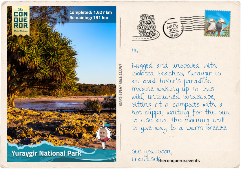
km od začátku : 1627
Yuraygir National Park
Except for a few camping spots and tiny beach villages, Yuraygir National Park protects the longest stretch of undeveloped coastline and untouched bushland in NSW. At 65,000 hectares and a 40mi (65km) coastline, Yuraygir is a merger of two previous national parks, making it the largest coastal park in NSW.
The coastline is dotted with pale sandy beaches, interspersed with rocky headlands, sand ridges, and cliffs, and divided by river estuaries. Further inland, the landscape features lakes, bogs, and swamps formed by sea level changes over millions of years. Notably, the lakes of Minnie Water and Hiawatha are perched freshwater lakes surrounded by massive dunes.
For long-distance hikers, bushwalking the length of the coast through a series of trails, beaches and rock platforms would be the highlight. It takes about 4-5 days to thru-hike, starting in Red Rock and ending in Angourie. However, extra time must be added when the sea is rough, as some beaches may be unpassable even at low tide.
The landscape is a mix of coastal rainforest, dry eucalypt forest with blackbutt and red bloodwood, and wetlands with swamp mahogany, swamp oak and melaleuca with yellow flowers similar in shape to bottlebrush.
Wildlife is abundant, mostly smaller animals, but at dawn or dusk, there’s a chance to see eastern grey kangaroos or red-necked wallabies. Reptiles like the spiky eastern bearded dragon, lace monitor, and skinks scurry around on the ground. Birdwatchers will appreciate catching a glimpse of the red-tailed black-cockatoo—a large, beautiful parrot with distinctive red panels on the male’s tail and stripey orange-yellow markings on the female. Their raucous call has been likened to a "rusty windmill".
A declining and isolated population of coastal emus, numbering fewer than 60, inhabits the low-lying heathland and scrub within the park. These emus are genetically distinct from other emus due to their centuries-long isolation. Unfortunately, their limited genetic variation poses challenges for adapting to ongoing environmental changes. However, while they are still around, these 6.5ft (2m) tall emus are hard to miss and a pleasure to see across the landscape. They are flightless birds and the second largest in the world after the ostrich. They live in pairs, and the male rears the young until they are 2 years old. Don’t try and race these birds. They may not fly but can run up to 31mi/h (50km/h). In some urban areas, they’d get speeding tickets at this rate.
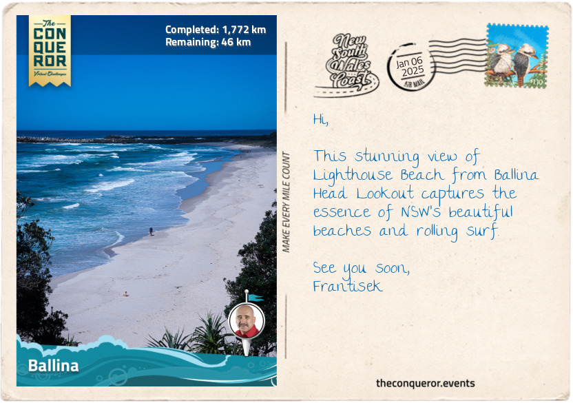
km od začátku : 1772
Ballina
“The Best Catch in Ballina is the Big Prawn”
Remember when I was in Coffs Harbour and mentioned Australia’s passion for big things? Now, I’m in Ballina, facing the Big Prawn directly across the street from Bunnings Warehouse, one of Australia’s largest hardware stores. If you visit on a Sunday, many Bunnings stores host a sausage sizzle, with funds raised going back into the community—a tasty way to fundraise while accumulating steps as you wander around the huge warehouse.
Bunnings went a step further in helping the community when it purchased the site where the Big Prawn stood. This concrete and fiberglass landmark was built in 1989 without a tail atop a service station by Hungarian brothers who constructed service stations around the NSW region, figuring that adding big things as features would draw visitors' attention. They also constructed the Big Merino in Goulburn and the Big Oyster in Taree.
The brothers hired art student James Martin to design the Big Prawn. Martin studied prawns in detail and scaled his final plan to 30,000 times larger than a real prawn. When it first opened, the prawn had an internal staircase allowing visitors to climb inside its head and view the surroundings through its perspex eyes.
While Australia has a thing for big things, the Big Prawn was also built to commemorate the local prawn industry, as Ballina is where the method of netting prawns was pioneered. When the service station closed in 2010, the local council agreed to demolish the prawn. However, locals opposed the demolition vehemently, and this is where Bunnings stepped in, buying the site. They removed the prawn, refurbished it, added a tail, and propped it up on a steel frame, ensuring it continued to be listed as one of Australia's Big Things.
Ballina is located on the north bank of Richmond River and serves as the gateway to Byron Bay, where my journey will end. The traditional owners are the Bundjalung people, who have occupied the area for over 6000 years. European settlers arrived in 1828 aboard the HMS Rainbow when Captain Henry Rous explored Richmond River as far as Broadwater, about 15mi (25km) southwest of Ballina. The next round of settlers were cedar-cutting parties who travelled up from Clarence River, arriving onboard the Sally. They would soon be joined by other parties trekking overland.
In 1928, Sir Charles Kingsford Smith, an Australian aviation pioneer, crossed the Ballina coast when he piloted the first transpacific flight. In 1973, the Las Balsas Expedition, consisting of three rafts made from balsa trees, left Ecuador to sail 8,600mi (13,850km) across the Pacific Ocean to Australia. Blown off course from their original destination in Queensland, the rafts reached Ballina. Two were towed into port, while the third was too waterlogged and cut loose. After 178 days at sea, the 12-man crew stepped safely onto terra firma. One of the rafts is displayed in Ballina’s Maritime Museum.
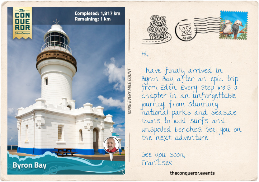
km od začátku : 1817
Byron Bay
Recognised as the traditional lands of the Arakwal, Minjungbal and Widjabul people, who have lived here for 22,000 years, Captain James Cook anchored in Cape Byron, naming it after Vice-Admiral John Byron, known for his attempt to circumnavigate the world in the 18th century. Incidentally, John Byron is the grandfather of Lord Byron, the author of the famous poem Don Juan.
Byron Bay's early days were like many other settlements, with timber as the main industry, followed by farming, fishing, whaling, and a brief stint in gold mining. However, it was the 1960s that truly marked a turning point for the town, as longboard surfers discovered the exhilarating waves around the cape, putting Byron Bay on the map.
During this time, hippies and those seeking alternative lifestyles flocked to the area, drawn by its natural beauty and laid-back atmosphere. This era defined Byron Bay as a haven for free spirits and creatives. Yet, as the 1980s approached, development gained momentum, attracting affluent travelers and shifting the town's character toward luxury accommodations and upscale amenities.
It's hard to believe that this town, with its population of just 5000 permanent residents, hosts over 2 million visitors annually. But as I explore the town and head up to Cape Byron Lighthouse (c. 1901), I understand why people from all walks of life are drawn to this coastal haven.
Certainly, the sweeping views from the lighthouse are absolutely breathtaking. I accessed several vantage points via a well-paved track. I walked through the rainforest of Bangalow palms and ancient burrawangs (cycad), then down to Wategos Beach to watch the surfers before heading to the most easterly point of the Australian mainland.
Back at the lighthouse, I took a moment to appreciate the structure and its role as a navigational landmark along the NSW coast. It provided safe passage to marine vessels as they plied the waters, trading up and down the coast. I eased into a weathered bench, the sun warming my face, and reflected on how far I had come since I began my journey in Eden. My travels led me through a tapestry of national parks, endless stretches of beaches and charming coastal towns. With each step, I catalogued a long list of native flora and fauna, illustrating the wonderfully rich land and the diversity of its inhabitants.
As I take out my packed lunch of none other than an Aussie classic, the Vegemite sandwich, and pour a cuppa from a flask, I plug in my earphones to capture the last essence of Australian culture through another classic, the 1981 Men at Work song Down Under.