The Pacific Crest Trail (PCT) is located on the westside of the United States. The PCT is part of America’s National Trails System that connects 88,610mi (142,600km) of scenic, historic and recreational trails. The PCT in the west and the Appalachian Trail in the east were the first to become part of the National Scenic Trails. Joined by the Continental Divide Trail, together they form the Triple Crown of Hiking in the US.
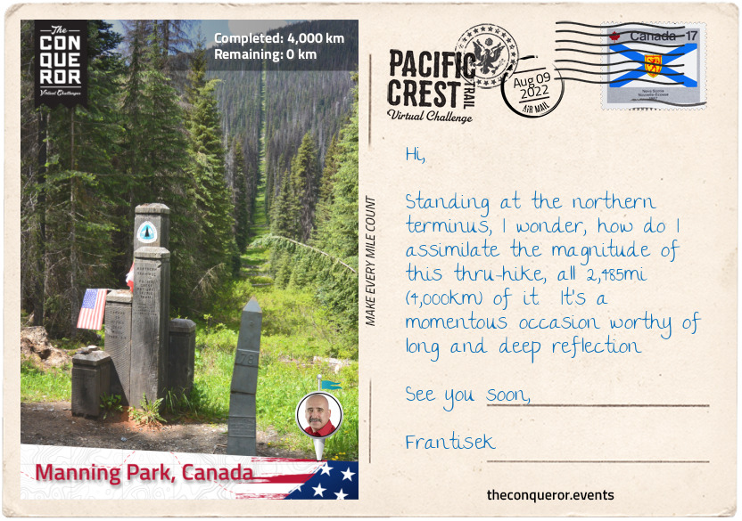
The PCT commences in Campo on the border of United States and Mexico and travels north through California, Oregon and Washington states terminating in Manning Provincial Park in the province of British Columbia, Canada.
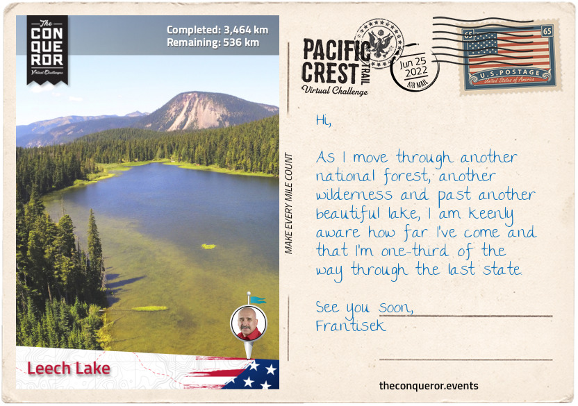
The trail passes through 25 national forests and 7 national parks with the highest elevation at 13,153ft (4,009m). Almost two-thirds of the trail will be spent in California. The midpoint is near Butt Mountain to the west and the town of Chester to the east.
A thru-hike on the PCT takes approximately five months which is pretty much the entire snow-free season, averaging 15mi (24km) per day, give or take and not taking rest days into consideration. Starting any earlier or later increases the risk of encountering snow conditions which could prove deadly or needing to quit the thru-hike.
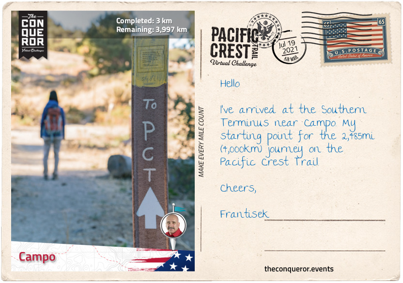
To begin this journey, I arrived in Campo, a small community of approximately 2,700 residents. Campo was once a military town during WW2 and home to the “Buffalo Soldiers” who were an all-black regiment established by Congress in 1866. Many of the Buffalo Soldiers served as the first national park rangers in California’s Sierra Nevada. The oldest serving Buffalo Soldier was Mark Matthews, who joined the 10th Cavalry Regiment at age 15 in 1909 and lived to 111 years of age, passing away in 2005.
Campo is home to the Pacific Southwest Railway Museum showcasing a collection of locomotives and railroad cars, retired railroad signals demonstrating how they work and a railway library containing the second largest collection of railroad history in California.
One and a half miles (2.4km) south of Campo is the Southern Terminus monument. The monument together with its northern twin was originally erected in 1988 to commemorate the National Trail System Act’s 20th Anniversary. In January 2016 the rotted five fir pillars were replaced with new ones designating the beginning of the PCT. Here, with the border wall as a demarcation of the two countries, on a dusty desert trail I start my trek northward bound.
km od začátku : 0167
Warner Springs
Leaving Campo, the trail passes through Lake Morena County Park, a lakeside camping site known for its fishing, picnicking, hiking and boating. Located southwest of Laguna Mountains the park is a combination of desert, coastal and mountain habitat. Bobcats, bald eagles and waterfowls can be seen within the park’s thick and dense shrubs.
The trail swings beneath Interstate 8 at Boulder Oaks and snakes its way through to the rim of Mount Laguna. A small town of 57 residents, Mount Laguna sits at 5,777 ft (1,761 m) within a forest of Jeffrey pines (Pinus jeffreyi), which are large coniferous evergreen trees that grow between 82-131ft (25-40m) tall. The trees were named after 19th century Scottish botanist John Jeffrey, who discovered this species of tree in 1852. With a general store in town this is a perfect place for restocking supplies.
Skirting around Monument and Garnet Peaks the trail occasionally travels along county highway S1 until it veers right around the base of Granite Mountain and meets up with county highway S2. Highway S2 is known as the Great Southern Overland Stage Route because it follows the former route of the Southern Emigrant Trail, an immigration route into California from the eastern United States during the gold rush era in the mid-1800s.
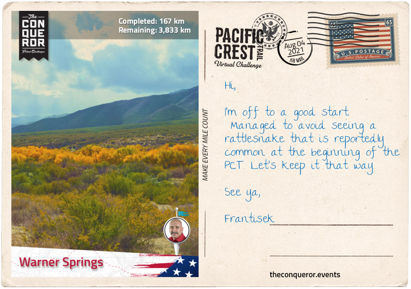
Crossing highway 78 in the San Felipe valley, the trail winds its way through the San Felipe hills all the way to Warner Springs. About 3mi (5km) before reaching town, to the right of the PCT is the natural formation known as Eagle Rock. Made of a collection of giant boulders, this formation takes the shape of an eagle with its wings spread as if ready to take flight. It stands majestically on a hill surrounded by a expanse of grassland and mountains in the distance.
Leaving Eagle Rock, the grassland trail eventually merges into a thicket of shrubs followed by groves of old oak trees before it reaches a town at Hwy 79.
Warner Springs was originally occupied by the Cupeno people, a Native American tribe. When the Spanish missionaries arrived they founded a small community in 1818. St Francis of Assisi chapel was established in 1830 which continues to exist today and still conducts service.
Near Warner Springs is the historical landmark Warner Ranch House. Built in 1849 it served as a way station for the emigrants on the Southern Emigrant Trail between 1849 and 1861. It was owned by American citizen John Trumbull Warner who was a fur trader from Connecticut. He became a Mexican citizen in 1844 and changed his name to Juan Jose Warner. Shortly after he obtained rights to Rancho San Jose del Valle where he established a successful cattle ranch. Most of his workforce was made up of the Cupeno people who were living in a nearby village.
Juan Jose lost his land and ownership transferred to John G Downey in 1880 who began legal proceedings to have the Cupeno people evicted from the ranch. The Cupeno lost the case and in 1903 were relocated to Pala Indian Reservation.
km od začátku : 0324
Cabazon
Crossing Hwy 79 from Warner Springs, the trail winds and climbs passing east of Coombs Peak with a short quarter mile (400m) hike to the summit from the PCT. Marked by frequent cairns (heap of stones) along the way, the hike is a challenge largely due to loose rocks and steepness. However, views of Salton Sea to the east, Lake Henshaw to the southwest, San Jacinto and San Gorgonio mountains to the north make it a worthwhile side trip.
The trail continues crossing a couple of small dirt roads before reaching Hwy 74 with Cahuilla Reservation to the west and the Santa Rosa Reservation to the east. Both reservations are home to the Native American people of the Cahuilla Nation. The town of Anza in the Cahuilla Reservation was named after Juan Bautista de Anza, a Spanish officer who led an expedition into California in the late 18th century.
Crossing Hwy 74 the trail ascends onto the ridge of the San Jacinto Mountain Range. Through a series of switchbacks the trail passes Pine Mountain Ridge to the east. The ridge is made up of thick layers of sandstone that are particularly hard and resistant to weathering. Its ecoregion is split into chaparral (thick shrubs/dwarf trees) on the lower slopes and thick pine forest and incense cedars (a type of conifer) on the upper slopes.
Staying atop San Jacinto’s ridge the trek continues through the woodlands of the San Bernardino National Forest passing several peaks to the west at over 7,000ft (2,100m) such as Palm Peak View, Spitler Peak, Apache Peak and Antsell Rock before reaching Tahquitz Peak at nearly 8,800ft (2,680m). The trail then dips slightly trekking through Saddle Junction swinging westward to Strawberry Junction and entering Mount San Jacinto State Park. The trail passes several 10,000+ft (3,048m) peaks to the east with San Jacinto Peak being the highest at 10,834ft (3,293m). For sea level dwellers it would not be unusual to experience altitude mountain sickness.
One of the highlights of the State Park is the Palm Springs Aerial Tramway. Opened in 1963 it is the largest rotating aerial tramway in the world. Ascending from Coachella Valley to San Jacinto Peak the tramway takes 12.5 minutes to reach the top. It passes a sheer mountain face, travelling through five life zones. The trip starts in the desert and ends in an alpine forest.
Coming upon Fuller Ridge the trail starts its descent through some very tight switchbacks into Snow Creek, a small village in a valley. A little further along is Interstate 10 (I-10) and swinging west is the town of Cabazon.
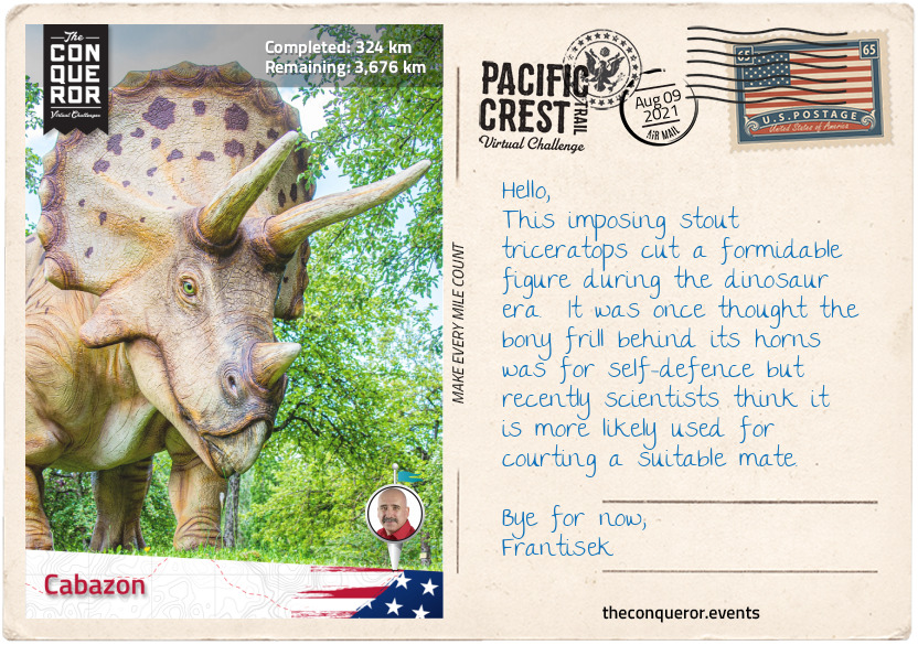
Cabazon is a small town of about 2500 residents but what it is really known for is its dinosaur roadside attractions. Two enormous steel-and-concrete dinosaurs are seen from I-10. One is a 150ft (46m) long Brontosaurus and the other a 65ft (20m) tall T-rex. Built by sculptor Claude Bell in 1964, its original purpose was to attract customers to his nearby restaurant. Today it’s a museum with 50 robotic dinosaurs, a dinosaur dig and fossil panning.
km od začátku : 0526
Crowder Canyon
Back in the woodlands the trail crosses the Whitewater Canyon, home to bighorn sheep, deer and bears. The nearby Whitewater Preserve is 2,851 acres and the Conservancy Association proactively engages in the conservation and preservation of the area, restoring wilderness, purchasing land to retire grazing cattle and removing neglected buildings and non-native diseased trees. One of their great success stories is transforming the Whiteware River from “black water cattle wallows into crystal clear waters”.
Travelling north on a single track through a narrow pass the trail hooks left towards the city of Big Bear Lake. Located on the banks of Big Bear Lake and surrounded by San Bernardino National Forest, the city is known for its ski resorts and recreational lake. At 7mi (11km) long and 1mi (1.6km) wide, the lake is popular with anglers due to the abundance of fish.
Hollywood film producers used the location for the films Gone with the Wind, Daniel Boone and Paint Your Wagon (1969) musical with legends Lee Marvin and Clint Eastwood.
Jordan Romero, a native of Big Bear Lake, is known for his summit of Mt Everest at the tender age of 13 (2010) and completing all 7 Summits by the time he was 15.
The trail passes Delamar Mountain and winds its way until it crosses a fishing spot on Deep Creek. Swinging right, the trail travels north along the creek to Aztec Falls, a crisp swimming hole with a short cascade feeding the pool.
For the next 15mi (24km) Deep Creek remained a constant companion first to the east and then crossing to the west of the PCT, never too far if I needed access to water. However, there’s nothing like taking a load off to bask in natural hot springs at Deep Creek Hot Springs just off the PCT. Great way to rejuvenate and soothe the weary body and battered soles.
Deep Creek and I parted ways when I turned left to travel to Silverwood Lake, a large reservoir built in 1971 as part of the Cedar Springs Dam construction. The construction inundated the town of Cedar Springs and as such all its residents had to be relocated.
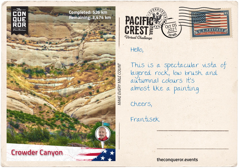
After another 15mi (24km), I arrived at Crowder Canyon next to Interstate 15. In the early-mid 19th century the canyon served as a trade route connecting Santa Fe, New Mexico to Los Angeles and Southern California. It was an arduous 700mi (1,100km) route. Following in the footsteps of these early traders, I crossed beneath the Interstate leaving San Bernardino National Forest behind and entered the Angeles National Forest.
km od začátku : 0697
Agua Dulce
The Angeles National Forest was established in 1908 and it was the first National Forest established in California. It is located within the San Gabriel Mountains to the east and Sierra Pelona Mountains to the northwest. About 100mi (160km) of my trail travels through the forest from east to west.
Just north of the densely populated Greater Los Angeles, this 700,176 acres forest offers five wilderness areas that are federally protected under the Wilderness Act. The Act describes wilderness as "an area where the earth and community of life are untrammelled by man, where man himself is a visitor who does not remain" and "an area of undeveloped Federal land retaining its primeval character and influence, without permanent improvements or human habitation, which is protected and managed so as to preserve its natural conditions."
Hollywood film producers used the location for the films Gone with the Wind, Daniel Boone and Paint Your Wagon (1969) musical with legends Lee Marvin and Clint Eastwood.
The forest is home to several wild animals such as black bears, cougars, bighorn sheep, coyotes and rattlesnakes.
The landscape is primarily chapparal shrub with oak woodlands along with trees such as coulter pine, California walnut and big cone Douglas-fir. About 4% is old-growth (primary forest) with a collection of Jeffrey pine, mixed conifer, ponderosa pine, white fir and lodgepole pine.
The San Gabriel Mountain Range lies between Los Angeles Basin and the Mojave desert with the San Andreas Fault as its northern border. It consists of 20 mountains/peaks ranging from the smallest, Echo Mountain (3,210ft/980m) to the tallest Mt San Antonio (10,064ft/3068m).
Some notable mountains are:
● Mt Baden-Powell named after the founder of the World Scouting Movement, Robert Baden-Powell. The PCT passes within a quarter mile (400m) of the summit;
● Mount Burnham named after military scout Frederick Russell Burnham who taught scoutcraft to Robert Baden-Powell;
● South Mount Hawkins was named after Nellie Hawkins, a famous waitress of the Squirrel Inn (no longer exists). The fire lookout tower, the only all-wooden tower in Southern California, stood here for 67 years until a forest fire destroyed it in 2002.
● Mount Disappointment unfortunately got its name when USGS surveyors thought it was the highest peak in the immediate area to then disappointingly discover that San Gabriel Peak half a mile (800m) away was taller. It was also the site for Nike missiles between 1955-1965.
To the right of the PCT is the Mountain High Ski Resort West, East and North. The west resort was originally known as Blue Ridge and it is one of the oldest ski resorts in the country starting operations in 1937. The east resort was opened in 1948 and a ski ticket in the 1960s was $1.50. The north resort often lacks in snow so it is primarily used as a ski school, tubing and for snow play.
The trail descends onto Soledad Canyon Road and crosses the Santa Clara River. This 83mi (134km) long river starts in Gleason Canyon flowing north before winding west through Soledad Canyon and continues until it empties into the Pacific Ocean.
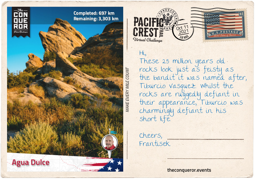
Finishing the last 10mi (16km) I arrive in Agua Dulce, a small town with a population of about 3,300 residents. It is located in the Sierra Pelona Valley with the Vasquez Rocks within it. The Rocks are known for their unique formation, a result of sedimentary layering and seismic uplift. It is a very popular filming location and historically known as the hideout for the famous bandit, Tiburcio Vasquez.
km od začátku : 0877
Tehachapi Pass
Heading north from Agua Dulce the trail enters the brushy landscape of Sierra Pelona, a mountain ridge that borders the San Andreas fault to the north and lies within the Angeles National Forest. Divided from San Gabriel Mountains by the wide Soledad Canyon, Sierra Pelona is flanked by Santa Clarita valley to the south and Antelope Valley and Mojave Desert to the north beyond the Fault. It has a Mediterranean climate and it is covered in chaparral shrubs, yucca, short grasses and scrub oak trees.
Swinging west the trail passes by several rural towns such as Green Valley, Lake Hughes, Three Points and Neenach. Three Points lies southwest of Antelope Valley which encompasses the western tip of the Mojave Desert. The valley has a desert ecosystem and is home to a wide range of plants notably the California Juniper, Joshua tree, creosote bush, the small evergreen California Scrub Oak and the wildflower California poppy.
Common species found in the valley are squirrels, mule deer, rattlesnakes, hawks, mountain quail and Stellar’s jay, a charming bird with a black head and upper body and blue on the bottom half, closely related to the Blue Jay.
Interestingly the valley was named after a species called pronghorn because they looked like antelopes which they are not. They are however colloquially referred to as American antelope. Pre-19th century the pronghorn grazed in the valley in large numbers until they were hunted for their fur by settlers and eventually migrated to Central Valley.
After 56mi (90km) in the woodlands of Sierra Pelona, the trail heads north once again for a hot and dry hike across the San Andreas Fault Zone and western arm of the Mojave Desert. The San Andreas Fault is the sliding boundary between two tectonic plates. The Pacific Plate to the west moving northwards and the North American Plate to the east moving southwards. It runs for approximately 750mi (1,200km). The Vasquez Rocks in Agua Dulce are evidence of the San Andreas fault at work. The most striking and noticeable section of the fault line lies in the Carrizo Plain, a long treeless plain where the fault presents itself like a deeply cut and raised scar.
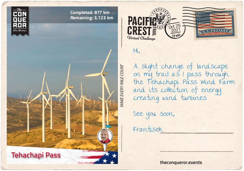
Passing by several wind farms the trail climbs to Tehachapi Pass, a mountain pass that crosses the Tehachapi Mountains and marks the boundary with the Sierra Nevada range. Before American settlement in the 19th century the pass was a trade route for the Kitanemuk people who lived in the Tehachapi Mountains and the Antelope Valley.
km od začátku : 1008
Walker Pass
Crossing State Route 58 via an overpass, the trail enters the Sierra Nevada range. This 400mi (640km) long and 70mi (110km) wide mountain range stretches from the Tehachapi Pass in the south to Fredonyer Pass in the north. It is home to 3 National Parks, 10 National Forests, 27 protected Wilderness Areas, the largest tree in the world by volume, largest alpine lake in North America and the highest peak in the contiguous United States.
The name “Sierra Nevada” which translates as Snowy Mountains was a term originally given in 1542 describing a less familiar mountain range in the interior. However, when Pedro Font, a Franciscan missionary and diarist, saw the ranges he applied the name on his 1776 Mar del Sur map and it stuck. As an expert at navigational equipment, Pedro joined Juan Bautista de Anza on a trek to Alta California. Maintaining a diary he kept a detailed account of Anza’s expedition to establish a Spanish base on the North American west coast. His diary can be found at the John Carter Brown Library, Rhode Island.
This section of the PCT from Tehachapi Pass to Walker Pass treks through the southern part of the Sequoia National Forest. Named after the giant sequoia tree, the “forest protects the largest concentration of giant sequoias on the planet” and various environments from semi-arid canyons to granite peaks. Originally established in 1893 by President Benjamin Harrison it was known as the Sierra Forest Reserve and it was the largest reserve with over 4 million acres. When President Theodore Roosevelt added land by Presidential Proclamation the Reserve was encompassed within the National Forest.
The National Forest has 38 distinct groves of giant sequoias including different species of pine and fir trees and six wilderness areas of which Kiavah Wilderness is on this section of the PCT.
Kiavah Wilderness is within the Scodie Mountains, a low mountain range which rises out of the Mojave Desert. The 88,290 acre wilderness was created in 1994 as part of the California Desert Protection Act and it is only one of two protected areas that support the pinyon-juniper woodland in California. Joshua trees, canyon oak, Mormon tea, sagebrush are some of the plants found here with a wildflower display during the spring period. The “Walker Pass milkvetch” is a rare wildflower endemic to the area. It was discovered in 1982 when a new section of the PCT was constructed. Some 17mi (27km) of the PCT runs through the wilderness. The plant is so rare that there’s very little information about it. There are less than ten populations of this plant found and all within the same county.
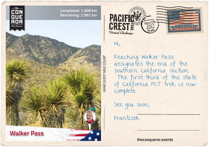
This section of the trail ends at Walker Pass which is designated a National Historic Landmark. It was named after John Rutherford Walker, a 19th century mountain man and scout, who after learning of the pass from Native Americans charted a route and mapped it. Nine years later he returned and led an immigrant wagon train through the pass.
km od začátku : 1180
Crabtree Meadows
Continuing through the Sequoia National Forest the trail meanders around the side of Morris Peak, gains a little more elevation skirting Mt Jenkins to the west and passes through the western side of Owens Peak Wilderness. At its centre is Owen Peak the highest point (8,452ft / 2,576m) in the southern Sierra Nevada Mountains.
Owens Peak was named after explorer Richard Owens by John C Fremont, another explorer who was also a military officer and politician. Fremont undertook five expeditions into the western United States during the 1840s and Owens accompanied him on his third expedition in 1845. Fremont held Owens in high regard and as such also named a valley, river and lake after him. During the Mexican-American War from 1846-1848, Owens served as Captain in Fremont’s California Battalion.
From Owen Peak the trail winds significantly laterally gaining and losing altitude until Sawtooth Peak when it swings northwest and crosses Chimney Creek, into Chimney Creek Campground, past Chimney Peak Wilderness to the west and Chimney Peak to the east. I can’t help but think that’s a lot of Chimneys.
Traversing relatively dry terrain, the trail reaches the South Fork Kern River near Kennedy Meadows. This 95mi (153km) river is a tributary of the Kern River and the southernmost river on the western slope of Sierra Nevada. The lower part of the river was once inhabited by Native Americans, however, when gold was discovered in the area in the mid-1850s and permanent settlement was built, conflict ensued until the US Army established a military post and controlled the area.
Crossing the South Fork Kern River on Kennedy Meadows Bridge, the route begins an ascent of 3,300ft (1,000m) to Cottonwood Pass alternating between large meadows and conifer forests, crossing the river once again just before reaching Deer Island. Of course it’s not actually an island, it’s a peak surrounded by vast plains and Cow Canyon.
The Olancha Peak is a fascinating mountaintop. When viewed from certain angles the ridge gives the impression of a human profile. Depends how one perceives the view it could be the face of a man and hence referred to as “Indianhead” or the figure of a woman lying on her back referred to as “the Sleeping Maiden”.
Passing through Golden Trout Wilderness, Mulkey Pass and Trail Pass, then skirting around Trail Peak the trail arrives at Cottonwood Pass at an elevation of 11,200ft (3,413m). Slightly to the northwest of Cottonwood Pass is the scenic Chicken Spring Lake nestled in a cirque. To the south the lake is covered in rocky meadows and foxtail pines whilst to the north and east sheer granite cliffs rise above its shores.
The last 14mi (23km) meanders at the same altitude with subtle undulations to Crabtree Meadows. This lush green meadow with a creek running through it is surrounded by a dense forest of pine trees with views of Mount Whitney’s west face just beyond.
km od začátku : 1453
Tuolumne Meadows
A short hike from Crabtree Meadows is the John Muir Trail. The trail with its southern terminus at the summit of Mt Whitney descends the western slopes and joins the PCT. Mt Whitney is the tallest mountain in contiguous United States with an elevation of 14,505ft (4,421m). It was named after Josiah Dwight Whitney, an American geologist whose extensive experience made him the foremost authority of his day in economic geology.
The mountain is partially dome-shaped with jagged ridges flanking the sides. Its west slope is in Sequoia National Park whilst its east slope is in Inyo National Forest. With its alpine climate very few plants grow near the summit except for the colourful sky pilot, a perennial plant that grows 4-16in (10-41cm) with blue or pink flowers and the cushion plant that grows low to the ground.
On Whitney’s summit is the Smithsonian Institution Shelter, a stone hut built in 1909 after a hiker was struck by lightning whilst having lunch.
The John Muir Trail joins the PCT for the next 169mi (272km) travelling over eight named passes that exceed 11,000ft (3,352m) and a collection of 17 named lakes. Forester Pass at 13,153ft (4,009m) is the highest point on the PCT and it sits on the boundary between Sequoia National Park and Kings Canyon National Park. The lakes up in the High Sierra, are a result of glaciers creating basins that filled with water. There are thousands of lakes and pool ponds in this region. The trail crosses several creeks and around several unnamed lakes.
No roads travel through the boundaries of the Sequoia National Park making it accessible only by foot or horseback riding. About 84% of the park is designated as wilderness making it home to an abundance of wildlife such as bobcats, foxes, mule deer and rattlesnakes and a rich landscape of various pine trees including Pinus Lambertiana, the tallest pine tree with the longest cones of any conifer tree.
One of the major highlights in the park is the giant sequoia tree known as General Sherman for being among the tallest, widest and one of the oldest trees on Earth. It stands at 286ft (86m) with a circumference of 113ft (34m) and estimated to be between 1800-2700 years old. The tree was named after American Civil War general William Tecumseh Sherman.
The Kings Canyon National Park was originally named General Grant National Park when it was established in 1890 and it was renamed in 1940. The General Grant sequoia tree, the second tallest sequoia tree, sits within this park and stands at 268ft (87m) with a circumference of 107ft (82m) and estimated to be around 1,650 years old. Named after the 18th US President, Ulysses S. Grant, in 1926 the tree was designated as the "Nation's Christmas Tree".
The two parks are managed together as Sequoia and Kings Canyon National Parks and in 1976 it joined the UNESCO Biosphere Reserve list.
North of King Canyon National Park is the Sierra National Forest followed by Yosemite National Park. The Sierra National Forest was established in 1893 and at the time the largest national forest with an area covering six million acres. By 1908 it had been broken up to make a series of other forests or parks. The John Muir Wilderness sits within this forest and the PCT travels through it.
Yosemite National Park is home to Devil Postpile National Monument, a basalt rock formation and Rainbow Falls, a 101ft (31m) high waterfall both within easy reach of the PCT. Yosemite was listed a UNESCO site in 1984 and it is 94% designated wilderness. It is one of the most famous parks known for its “granite cliffs, waterfalls, clear streams, giant sequoia groves, lakes, mountains, meadows, glaciers, and biological diversity”.
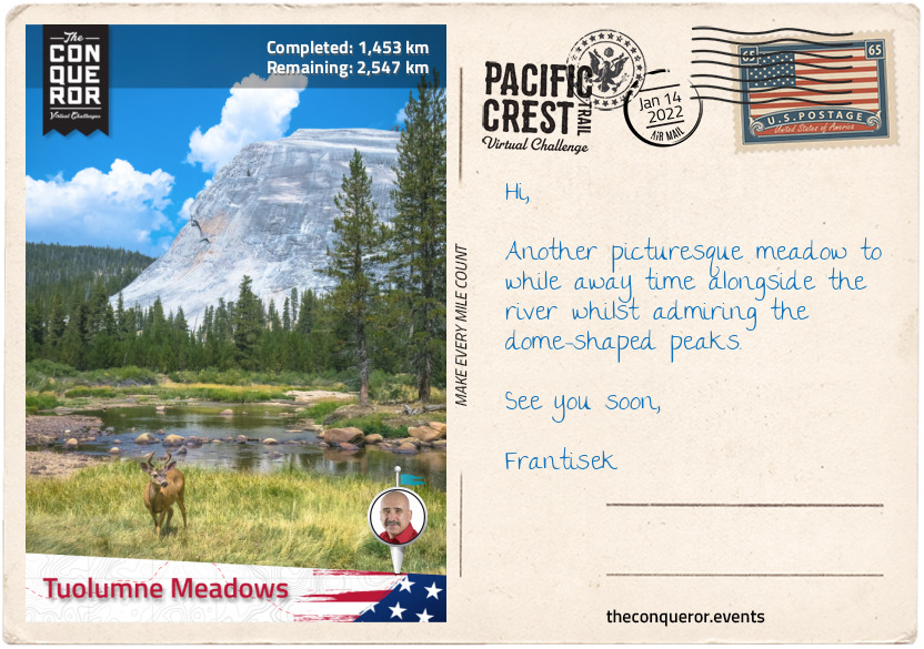
This section of the trek finishes at Tuolumne Meadows in Yosemite alongside Tuolumne River and at the junction of Tioga Pass Road, the highest paved through road in California’s State Route System. During the Gold Rush era the pass served as a pack trail for prospectors circa 1849 and by 1875 it was a wagon road extending to Yosemite Valley.
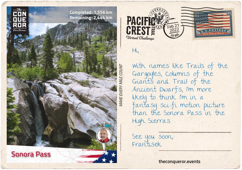
km od začátku : 1556
Sonora Pass
Leaving Tuolumne Meadow the trail reaches the confluence of Cold Canyon, Conness Creek and the Tuolumne River. Crossing a bridge over the river, the trail heads north before swinging west wading across Return Creek.
As it winds its way around past several peaks and waterways, of particular visual interest was the deeply snaking Matterhorn Creek as it flowed and carved its way through the landscape. Parting ways with the creek the trail then crossed the rather barren Benson Pass and onto Smedberg Lake to the right and Volunteer Peak to the left. Although Volunteer Peak isn’t high, famous or difficult to climb it is widely regarded for its stunning views.
Three miles (4.8km) further the trail crosses Piute Creek which less than half a mile (700m) away to the left of the PCT empties into Lake Benson. With a broad, sandy beach the lake sits at an elevation of 7,578ft (2,310m) with Piute Mountain rising above the lake to the northwest.
Arriving at Wilma Lake the trail meets with Falls Creek, a 24mi (39km) tributary of Tuolumne River. Northbound the creek becomes a constant companion for the next 8mi (13km), at times meandering away into the landscape before reappearing alongside the trail, until it veers off to its source on the east side of Dorothy Lake and the PCT to the west of the lake.
The trail passes through Dorothy Lake Pass, then sidles along the second half of Lake Harriet and onto Kennedy Canyon Trail Junction where views of wildflowers in bloom contrast with the surrounding granitic and volcanic mountains. The trail moves through the canyon like an arc and exits into Stanislaus National Forest and the Emigrant Wilderness.
Stanislaus Forest was established in 1897 and is one of the oldest national forests. Within its 898,000 acres the park has 78 lakes, 811mi (1,032km) of rivers and streams and 1,100mi (1,770km) of trails. A landscape of Lodgepole pine, Jeffrey pine and White Fir, the forest contains about 15% of old growth otherwise known as primary forest that has attained great age without human interference or disturbance.
The final stage of this section takes the PCT past Leavitt Peak and nearby Leavitt Lake, Leavitt Creek and Leavitt Meadow. The namesake is for Hiram Leavitt who in 1863 established a hostel near Sonora Pass for travellers passing through.
The Sonora Pass at 9,624ft (2,933m) is the second highest highway pass in the Sierra Nevada connecting the Sonora and Bridgeport communities. Back in the 1860s when gold and silver was discovered both towns on either side of the pass pushed to have a road built for easier transportation and trade. By 1865 a road was established and in use. Today the road over the pass is quite steep, narrow and winding making the traverse unsuitable for vehicles that are wide, heavy or long. During the winter period due to snow accumulation the pass is closed to traffic.
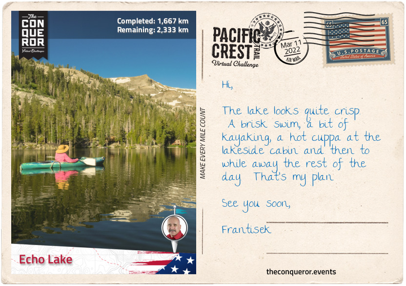
km od začátku : 1667
Echo Like
Heading northwest from Sonora Pass the trail rounds Sonora Peak and treks alongside East Fork Carson River in a valley till it commences an ascent and passes several peaks to Wolf Creek Pass and the nearby Asa Lake, a spring-fed lake located amongst woods and meadows.
Moving in and out of woodlands, the trail passes between Tryon Peak and Highland Peak with Noble Lake at the base next to the PCT and on to Ebbetts Pass.
Elevated at 8,736ft (2,663m), Ebbetts Pass is a high mountain pass and one of two passes that is traversed by State Route 4. Registered as a California Historical Landmark, the pass was named after John Ebbetts, a fur trader turned guide for California Gold Rush prospectors circa 1851. He thought the pass would be a viable place for a transcontinental railway but upon later examination he deemed it unsuitable. Although he wanted to return and survey the area further he unfortunately died in a steamer explosion three years later.
Just north of the Pass a little off the PCT is a lookout with views of the Kinney Reservoir below. With a little uphill hike, the trail then descends with Ebbett’s volcanic peak to the left followed by Sherrold Lake right next to the PCT. Another mile further (1.6km) are the Lower and Upper Kinney Lakes and together with the Reservoir are known to be popular fishing spots for brook, rainbow and trout.
Interestingly the 1864 Silver Mountain Mining District map has the two lakes marked as Silver Lakes. Sometime in the 1890s, Silver Creek was dammed to create the current Kinney Lakes and the reservoir, utilising it for irrigation purposes in Carson Valley. The dam for the lower lake was completed in 1926, and the upper lake in 1990. Several other reservoirs were built by 1912 to serve the agriculturists in the area.
Rounding Raymond Peak, the trail moves up and down gaining and losing about 400ft (120m) of elevation until I reached Wet Meadows Reservoir and realised how spoilt for choice I am on this section with a multitude of lakes on either side of the trail. There’s the Reservoir, Summit Lake, Lilypad and a Tamarack Lake to the left and Upper Sunset Lake (which joins with Lower Sunset Lake) plus two unnamed lakes to the right.
The trail climbs up the southside of Nipple Peak to 9,000ft (2,743m) and travels along the ridge with spectacular views of the Blue Lakes, Twin Lake and Meadow Lake below and the peaks of Markleeville and Jeff Davis to the northeast and east.
The two mile (3.2km) hike along the ridge is in the open on desolate landscape with no shade to escape to until it descends slightly near the headwaters of West Fork Carson River and there’s a short reprieve through chapparal woodland.
Crossing Forestdale Divide the trail meanders down into a valley, climbs across the Elephants Back mountain, past Frog Lake, through Mokelumne Wilderness and into Carson Pass. The Elephants Back is a volcanic rubble that is easily recognisable from Carson Pass and although it is overshadowed by its neighbours Round Top and The Sisters, it provides great views over Carson Pass and the Mokelumne Wilderness.
From Carson Pass the trail treks through Dixon Valley, past Showers Lake, through woodland and gently descending to 7,600ft (2,300m) straight into Echo Lake. The small community of Echo Lake is near the glacial lake of the same name. This 2mi (3.2km) long lake is divided into Upper and Lower lake and sits within the Eldorado National Forest.
Established in 1910, the Eldorado forest ranges from 1,000ft (300m) in the foothills to over 10,000ft (3,000m) along the Sierra crest. The forest is broken up with many steep canyons with plateaus at the base between them. Desolation Wilderness and Mokelumne Wilderness can be found within its boundaries. Most of the forest is made up of chapparal, oak woodlands, pine trees, fir trees and old-growth.
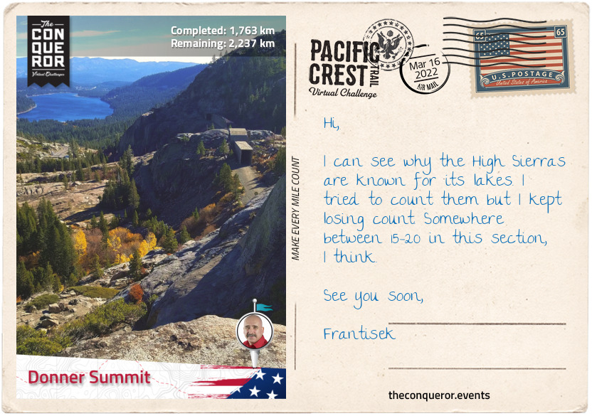
km od začátku : 1763
Donner Summit
Departing Echo Lakes, I travelled 24mi (38km) with a plethora of lakes as constant visual delights. Between Ralston Peak and Keiths Dome, beside each other in the basin are a tamarack lake and Ralston Lake. Both Ralston Peak and the Lake were named after William Chapman Ralston, who founded the Bank of California in 1864 making it the first commercial bank in western US and the second richest bank in the nation.
The path then followed the mountaintop through some snow with Lake Margery to the right and Lake of the Woods to the left, through Desolation Valley, passed Cracked Crag peak and the very large Lake Aloha, a backcountry reservoir within the Desolation Wilderness area. The lake was created in 1875 by damming Pyramid Creek as a year-round water source for grazing cattle.
Turning right from Lake Aloha, the trail descends to Heather Lake, then southside of nearby Susie Lake. As I skirted around Susie, I almost missed the fact that Susie is the source of a stream that culminates in a waterfall plunging down the mountain over several tiers flowing into Grass Lake below. Only the brink of the waterfall is visible from the PCT as the best view is from Grass Lake.
Halfway along the right side of Susie Lake, the trail turns left and winds its way through the landscape to Gilmore Lake. Ascending the western slope a third of the way down from the ridge, the trail hugs the side of the mountain to the right with a steep escarpment to the left with spectacular views of Half Moon Lake below flanked by Jack’s and Dick’s Peaks.
Crossing Dicks Pass at 9,200ft (2,800m) the trail descends to Dick’s Lake which is pressed against Dick’s Peak on the opposite side of Half Moon Lake. A third of a mile away (480m) from Dick’s Lake is Fontanillis Lake and just a little further along are the Velma Lakes. The PCT passes the Middle Velma Lake with Upper and Lower Velma Lakes just beyond. All these lakes are popular fishing spots for anglers who come up from Tahoe.
From here the trail descends to 7,600ft (2,300m) between Middle Mountain and Phipps Peak for a fairly straight northbound trek to Lost Corner Mountain to the east followed by Richardson Lake with Sourdough Hill opposite the lake. A short hike up Sourdough Hill is a must with expansive views of Lake Tahoe.
Back in the woods I forged onto Barker Pass, climbed a few switchbacks and followed the ridge line for about 2.4mi (3.9km) to Ward Peak. In the winter, a keen skier has a varied terrain to choose from at Alpine Meadows or Squaw Valley Ski Resorts which are to the east of the PCT.
Alternatively just off Interstate 80 at Donner Summit where this section of the PCT ends, are Sugar Bowl or Boreal Mountain Ski Resorts. Leading up to I-80 were another three picturesque lakes nestled amongst the rocky mountain and scattered woodland: Lake Angela, Flora Lake and Azalea Lake.
These resorts along with a few others off the PCT are part of the Lake Tahoe area within Tahoe National Forest, famous for winter sports, summer activities and surrounding scenery. A large portion of its economy is reliant on the winter season and ski resorts.
Lake Tahoe itself is an extraordinary ancient lake at least two million years old. It is the second deepest lake in the US with a depth of 1,645ft (501m). The lake is 22mi (35km) long, 12mi (19km) wide and has a shoreline of 72mi (116km). The California-Nevada state line runs right through the lake.
Naming the lake was quite the story. It’s first known name was Lake Bonpland but it never took. It was changed to Mountain Lake and then Fremont’s Lake which also didn’t stick. Fallen Leaf Lake (there is one now such named lake just south of Lake Tahoe) and Lake Bigler were both names given by the same person. Eventually in 1862 it was named Tahoe but it also didn’t seem to be favoured so it swung like a pendulum between Tahoe and Bigler until 1945 when it was affirmed by the California State Legislature as the official name – Lake Tahoe.
Donner Summit is the end of the central California section. This completes two-thirds of the PCT in the state of California.
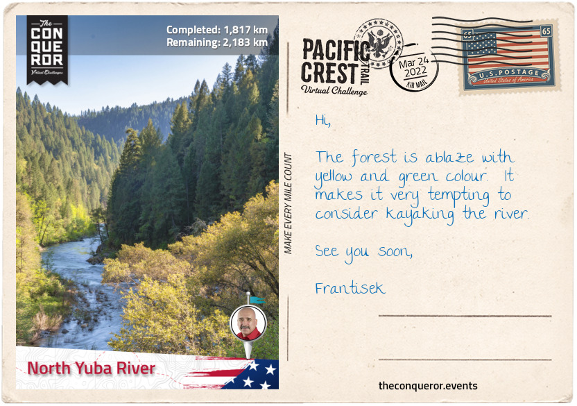
km od začátku : 1817
North Yuba River
Taking the underpass beneath I-80 the trail swings left past West Lakes and commences its northwest direction through thick woodland, over a crest and down, skirting Round Valley at the base of Basin Peak to the north and Castle Peak to the south. The two peaks are nicely connected via a trail atop the ridgeline at 9,000ft (2,743m) with views of the PCT and Round Valley below to the left and Frog Lake and Prosser Reservoir to the right.
After the valley the trail moves through several switchbacks within woodland, across North Creek via a bridge, up the mountain slope, descending to ford White Cross Creek, through Bear Valley and past the eastside of Jackson Meadows Reservoir.
The Reservoir is a result of damming Middle Yuba River in 1965 in order to control flooding and irrigation water storage. The dam is 195ft (59m) tall and 1,530ft (466m) long and it is part of the Yuba-Bear Hydroelectric Project.
At an elevation of 6,100ft (1,859m) the Reservoir has nine camping grounds of which Little Lasier Meadow is reserved for campers with horses and Jackson Point for boat-in campers.
Travelling through a densely wooded ravine alongside Milton Creek, the trail gently descends as it nears North Yuba River near Sierra City to 4,600ft (1,400m). Just beneath the bridge that crosses the river is Loves Falls, a small waterfall filled with rocks and boulders. North Yuba River is 61mi (98km) long and it is the main tributary of the Yuba River. As it drains westward through Sierra Nevada and the Sacramento Valley, the river takes a sharp southern turn and flows through New Bullards Bar Reservoir and into Middle Yuba River and finally forming the Yuba River.
The nearby Sierra City is located in the canyon of North Yuba River with a population of 220 residents. Originally settled in 1850 by Philo A. Haven and Joseph Zumwalt, three years later the settlement was completely destroyed by an avalanche. As gold mines were being developed in the area, Sierra City was rebuilt. In 1869, a gold nugget weighing 106 pounds (48kg) was discovered at the Sierra Buttes Mine, now known as the “Monumental Nugget”.
Towering over the town are the Sierra Buttes Peaks, a cluster of sheer rock peaks at 8,587ft (2,617m) with views of Mount Lassen and Mount Shasta in the Cascade Range.
This section of the trail is entirely within Tahoe National Forest located northwest of Lake Tahoe. Established in 1905 it has a total area 871,495 acres. The forest contains hundreds of lakes, reservoirs, river canyons, hiking trails and the Granite Chief Wilderness, and it provides water supply to several nearby towns including Reno and Sparks in Nevada.
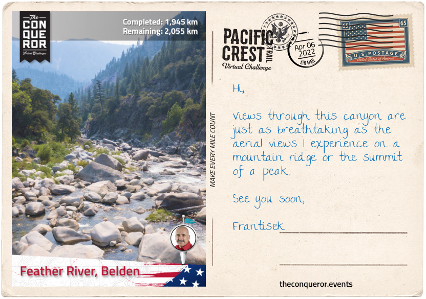
km od začátku : 1945
Feather River, Belden
A mile (1.6km) after crossing North Yuba River, the trail, through a series of tight switchbacks, sharply gains 1,400ft (426m) and continues to climb as it rounds the flanks of Sierra Buttes Peaks some 2,000ft (610m) above the town of Sierra City.
Travelling along the ridgeline, I’m taken by the vast views especially the large Gold Lake flanked by Deer Lake and Long Lake to the east of the trail and a little further along the lovely peaks of Mount Elwell and Mount Washington.
As I reach McRae Ridge (elevation 7,200ft/2,194m), I leave Tahoe National Forest behind and enter Plumas National Forest. The forest was established in 1905 by President Theodore Roosevelt. Within its boundaries is Bucks Lake Wilderness. Named after a primary watershed, Rio de las Plumas (translating as Feather River), the forest has a land area of 1,146,000 acres of which 127,000 acres are old-growth, mostly mixed conifers. Due to extensive logging during the gold rush era into modern times much of the original timberland has disappeared.
Descending into a valley to 6,000ft (1,829m) the trail skirts around the foot of Beartrap Mountain, then around the two closely located Mounts Stafford and Etna, across Bunker Hill Ridge to swing around Pilot Peak and then continue with a long, gradual descent to Grass Valley Bald Mountain and Little Grass Valley Reservoir below. The reservoir, accessed via Bald Mountain trail, is an artificial lake created when the dam was completed in 1961. Used as a recreational area the lake is 2mi (3.2km) long, one mile (1.6km) wide and 65ft (20m) deep. It’s shoreline is 14.5mi (23.3km).
Travelling through woodland across a ridgeline the trail further descends to 3,000ft (914m) alongside Onion Valley Creek where the trail crosses Middle Fork Feather River via a bridge. A major river, Middle Fork is nearly 100mi (160km) long of which just over three-quarters are designated National Wild and Scenic River. A remote and rugged landscape with huge boulders, cliffs and waterfalls it is seldom visited due to the difficulty of navigating the terrain and river.
Back in the forest the trail travels up and down, across Bear Creek and onwards to Bucks Lake and Bucks Lake Wilderness. Encompassing 21,000 acres the Wilderness was established in 1984. Filled with conifers, oaks and red firs, the Wilderness is littered with lakes to the east and small meadows to the west. It’s elevation is from 2,000ft (610m) in the Feather River Canyon to 7,017ft (2,139m) at Spanish Peak. The lake is a result of damming Bucks Creek in 1928.
Passing Spanish Peaks on the right the trail travels along a steep escarpment with views of Silver Lake below, onto Mount Pleasant, then Three Lakes to the left before a long and gradual descent to 2,400ft (731m) at Feather River near Belden.
At its main stem Feather River is 73mi (117km) long and is a major tributary of the Sacramento River. Starting at Lake Oroville the River is joined by its four branches: South, Middle, North and West Branch Feather Rivers. During the 19th century the river and its forks were a centre for gold mining. Today it provides water to the state and hydroelectricity generation.
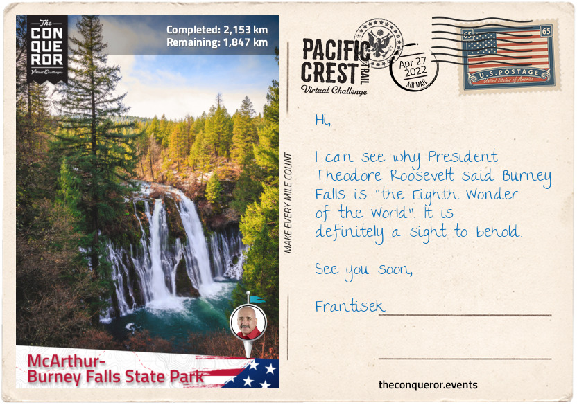
km od začátku : 2153
McArthur-Burney Falls State Park
Trailing along the mountain slope alongside Chips Creek, I have now entered Lassen National Forest. Named after pioneer, Peter Lassen, the forest was formed in 1905. A wide variety of animals are found in the forest including, black bear, coyote, cougar, chipmunk, woodpecker, salamander and wolves. The forest surrounds Lassen Volcanic National Park which includes the active volcano, Lassen Peak.
Whilst not near the trail it’s worth noting that Lassen Peak is where the Cascade Range starts, leaving Sierra Nevada behind. Lassen Peak rose 27,000 years ago out of a now-collapsed Mount Tehama. It has an elevation of 10,457ft (3187m) and its lava dome shape is the largest one on earth. Lassen last exploded in 1915 destroying nearby areas and spreading volcanic ash 280mi (450km) away. The National Park was created to protect the affected areas, to observe and study it and inhibit anyone from settling too close. The Peak is monitored by California Volcano Observatory.
At Humboldt Peak, the trails arcs to the right across Carter Creek Saddle, over the ridge near Butt Mountain on the left with views of Ruffa Ridge to the right.
Weaving through the woodland the trail descends to 4,400ft (1,341m) over Soldier Creek and ten miles (16km) later over North Fork Feather River, one of the Feather River branches. The trail remains wooded till I reach Little Willow Lake with Sifford Mountain and Kelly Mountain on either side of the lake.
A short hike off the PCT is Willow Lake a rare and special botanical environment. The shore is filled with a type of moss that has no soil so it becomes more like a wet meadow called a fen. The moss is known as sphagnum and it supports unusual plants such as American Scheuchzeria, a perennial plant with greenish-yellow flowers that once was thought to have been extinct until it was discovered at Willow Lake in 1988. Carnivorous plants such as English sundew and roundleaf sundew busily feast on trapped flies whilst Douglas spiraea and other herbs provide colour to the fen with their blooming flowers. Due to its fascinating environment, Willow Lake was designated a Botanical Special Interest Area.
Back on the PCT less than a mile (1.6km) northeast from Little Willow Lake is the Terminal Geyser spewing bubbling water from beneath. Another mile further on the PCT is Boiling Springs Lake an interesting geothermal feature. The milky froth surface of the lake is a result of an underground heat source producing hydrochloric acid and sulphurous fumes that are combined with water. Along the shore of the lake are boiling mud pots.
Hiking through Warner Valley and crossing King’s Creek the trail travels between Swan Lake on the right and Upper and Lower Twin Lakes on the left, around the base of Fairfield Peak, Prospect Peak, circling Badger Mountain and then up a steep slope using long switchbacks. Trekking along the edge of the slope, the trail descends into Plum Valley before ascending on the opposite side following the contour of the mountain, around a canyon and onwards till it finally descends again near Cinder Flats State Wildlife area, a woodland for bald eagles and deer nesting habitat, birdwatching and wildlife viewing.
Having reached Baum Lake, now was the final push to end this section. A slight off-route jaunt to see Lake Britton Bridge that featured in the 1986 Stand By Me movie and finishing up at Burney Falls in the McArthur-Burney Falls State Park. The park is the second oldest state park in California. The falls, 129ft (39m) high, are located on Burney Creek at the entrance of the park. It was named after Samuel Burney a pioneer settler from the 1850s. The descendants of the McArthur family who arrived in late 19th century saved the waterfall from development by buying the property and gifting it to the state in the 1920s. In 1954 it was designated a National Natural Landmark.
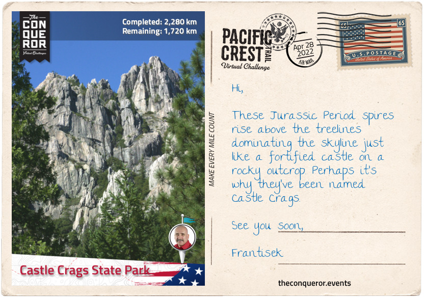
km od začátku : 2280
Castle Crags State Park
Having entered the Cascade Range, before I take off on my hike, let me give you an insight into this extensive mountain range. Running from north-south, the range is 700mi (1,100km) long and 80mi (130km) wide. It starts in British Columbia, Canada extending through Washington, Oregon and Northern California. With its highest peak in Washington State, the range is also home to several volcanic mountains. The Cascades are part of the Pacific Ocean’s “Ring of Fire” which are volcanoes and earthquakes that occur around the rim of the Pacific Ocean. The last two eruptions on contiguous US were in the early 20th century; Lassen Peak had its largest eruption in 1915 and Mount St Helens in 1980.
Crossing the dam at Lake Britton the trail begins to follow the contour of the mountains over DeLucci Ridge, along Rock Creek to JNM Falls to the left and shortly after Rock Creek Falls to the right. Gently ascending to 4,800ft (1,463m) the trail starts to climb further up to 5,400ft (1,645m) after crossing Peavine Creek.
The trail moves between forest and large open meadows around the edges of the mountains up to Mushroom Rock and just below Grizzly Peak offering stunning views of the valleys below between these two peaks. From Grizzly Peak the trail descends into a valley travelling alongside Deer Creek for about 5mi (8km) then crosses Butcher Knife Creek, past Doodlebug Gulch and then across McCloud River via a bridge.
McCloud River is a 77mi (124km) river named after hunter and trapper Alexander Roderick McLeod who once explored the area in 1830 and the river’s spelling was initially McLeod River. However, eventually the river’s name spelling changed partly to honour Ross McCloud an early pioneer settler of the mid 1850s who was instrumental in the improvement of roads and rail in the area.
The trail continues up and down through the thick woodland of Shasta-Trinity National Forest. Originally two separate forests, both established in 1905, they were merged in 1954 and their names combined. The forest encompasses 2,210,485 acres and within its boundaries it has five Wilderness designated areas, hundreds of mountain lakes including Shasta Lake, Mount Shasta (elevation of 14,179ft/4,322m) and a total of 6,278mi (10,103km) of streams and rivers.
Shasta Lake is the largest man-made lake in California and is a result of damming Sacramento River by Shasta Dam. The building of the dam started in 1937, providing much needed jobs at the time given the Great Depression era. Construction finished in 1945 a good 26 months ahead of schedule. It is 602ft (183m) high making it the 8th tallest dam in the US but at the time of completion it was the second tallest dam after Hoover and considered an engineering marvel. During WW2 the dam played a vital role by providing electricity to California factories as manufacturing efforts were redirected towards the war effort and California became a major ship and aircraft builder.
Reaching the slopes of Girard Ridge it was worth climbing up to Girard Lookout at 4,809ft (1,466m). Built in 1931 and used by the Forest Service untill 1981, the lookout is now a great place to get spectacular views of Sacramento River Canyon below, Mount Shasta to the north and Castle Crags to the west.
Another 10mi (16km) and the trail descended to 2,200ft (670m) across Sacramento River and into Castle Crags State Park. Sacramento River is a principal river in Northern California and the largest in California. It flows in a north-south direction for 400mi (640km), rising in the Klamath Mountains and flowing into San Francisco Bay. The river was named in 1808 by Spanish explorer Gabriel Moraga and when gold was discovered the river had an influx of people arriving to mine for gold. When gold mining ceased the settlers turned to farming and ranching in the area. By the 20th century large dams were built to impound the river and provide water to Central and Southern California. This changed the river’s original state greatly reducing the fish that inhabited the river.
Within the Castle Crags State Park are the grey spires of Castle Crag, dramatic rock formations from the Jurassic Period that rise up to 7,200ft (2,194m) at the summit of the highest crag. The formations were sacred to the Native Americans and the area an important source of clean water and food. However as the gold rush emerged, miners were filling the river with mud damaging the salmon run and killing the wild game for food thereby reducing the natural source of food for the Indian people. Conflict arose between the Indians and the immigrants giving way to the 1855 Battle of Castle Crags.
Following excessive mining and lumber operations land was purchased in 1933 to protect the area and a further parcel was purchased by the State ten years later which was the beginning of the State Park. Bordering the park is the Castle Crags Wilderness, an area of mixed conifers and 300 species of wildflowers, including Castle Crags Bellflower which only blooms here.
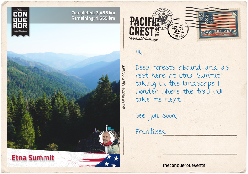
km od začátku : 2435
Etna Summit
Having climbed to 5,000ft (1,524m) and traversed most of Castle Crags Wilderness the trail wound its way around the mountain slopes and climbed further up to Devil’s Pocket. Heading west just below the ridgeline the trail was above a wide valley with views of Echo Lake at the base of Boulder Peak on the opposite side of the valley.
The trail takes a northerly direction past White Ridge and between Porcupine Lake to the left and Toad Lake to the right reaching an elevation of 7,400ft (2,255m). Traversing another slope, over a crest and past Deadfall Lakes, it then circles around the interior slope of a mountain with the peak of South China Mountain to the northwest.
Zig-zagging around and over to Bull Lake and the southside of Cory Peak, I continued to Kangaroo Lake which is located within the Klamath National Forest. Nestled amongst trees this 21 acre lake is known for its fishing of brook trout, a freshwater fish member of the salmon family.
Established in 1905, Klamath National Forest encompasses 1,737,774 acres of forest with a combination of pines, firs, cypress, cedar and old growth. There are four wilderness designated areas within its boundaries.
The historic church building, Sawyers Bar Catholic Church was built within the forest in 1855 by Father Florian Schwenninger and the first Mass was held in 1857. Graves dating as early as 1850 can be found on the churches grounds. The church was added to the National Register of Historic Places.
The trail winds southwest to Scott Mountain, around the southside of Eagle Peak then swinging north again to Russian Peak that sits within the Russian Wilderness Area at an elevation of 8,196ft (2,498m).
Russian Wilderness consists of 12,000 acres and it protects Russian Mountain, over twenty named lakes and the watershed of Scott River and North Fork Salmon River. Connecting to Trinity Alps Wilderness to the south and Marble Mountain Wilderness to the north, the Russian provides an important corridor for migrating wildlife.
From Russian Peak the trail continues north past Paynes Lake, across a rocky slope with Smith Lake below and descending to 6,000ft (1,829m) at Etna Summit where this section ends.
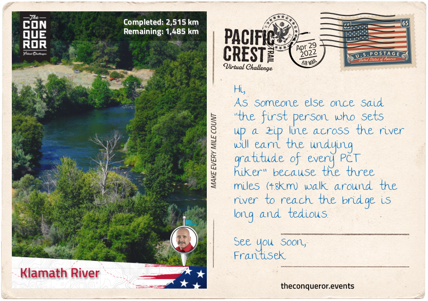
km od začátku : 2515
Klamath River
The next 15mi (24km) were quite uneventful travelling either on the ridgeline or just below until I arrived atop a crest with views of Cliff Lake in the large valley below and Campbell Lake beyond. Another 5mi (8km) along I come across Sky High Valley below with three lakes near each other: Upper and Lower Sky High Lakes and Frying Pan Lake. Looking north from up here I can see the striking white rocks of Marble Mountain above the treelines.
As the PCT reaches the junction with Marble Mountain Trail it veers to the right and descends into Little Marble Valley and then over white rocky terrain that is an extension of the mountain cliffs above. Marble Mountain sits within the Marble Mountain Wilderness. Besides the usual mix of oak, fir, pines and hemlock, at 225,114 acres the wilderness has a whopping 89 lakes. Wildlife such as bears and deer are plentiful. The PCT crosses the entire wilderness for 32mi (51km).
Marble Mountain is located in the heart of the Klamath Mountains and its bright white cliffs made of glacially polished granite are a sight to behold. Although the highest peak is the nearby Black Marble Mountain at 7,429ft (2,264m) what makes Marble Mountain’s peak interesting is its “long, curving, escarpment with numerous points along the rim”. It is broken into two segments separated by Marble Gap near the centre. To the east the mountain has a gradual slope which is where the PCT traverses it across Marble Valley, however, on the western side are sheer cliffs with Rainy Creek and Elk Creek at the base.
After Marble Mountain the trail passes Paradise Lake with Kings Castle Peak behind it then across Big Ridge, down into Cliff Valley and alongside Grider Creek till Klamath River where the trail skirts around the river bend and terminates this section in Seiad Valley at an elevation of 1,388ft (423m).
Flowing for 257mi (414km), the Klamath River travels through Oregon, Northern California and then empties in the Pacific Ocean. It is the second largest river in California by discharge. It begins in the high desert, flows through the Cascades and Klamath Mountains before reaching the sea. Inhabited by Native Americans for 7000 years, the river’s fish migration of salmon, steelhead and trout were their source of food. With the Europeans arriving the 1820s the Indians were, within a few decades, forced into reservations. Soon after the gold rush began and with the influx of miners the river became polluted. Steamboats operated in the upper basin untill the railroads arrived at which point it the area turned agricultural and dams were built to provide irrigation and hydroelectricity. Today the river is a recreational area and continues to provide water for agriculture.
Seiad Valley is a small community of 350 residents and only a mere 15mi (24km) south of the Oregon border. I will be taking a load off at the historic Wildwood Tavern and Lodge. Opened in 1929 as a one-story building and bar, it was sold, bought and remodelled many times across the decades except for the 24ft (7.3m) bar that has been lovingly preserved for the last 90 years. Today it continues to serve passing travellers.
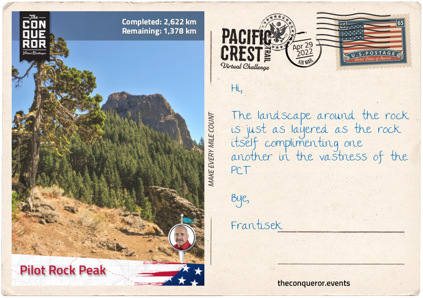
km od začátku : 2622
Pilot Rock Peak
The climb out of Seiad Valley was challenging to say the least with a 3mi (4.8km) steep ascent of 2,000ft (610m) and it continues climbing although a little gentler towards Kangaroo Mountain at 5,800ft (1767m) before descending down its southern flank and traversing at the foot of the mountain.
The trail takes a north-easterly direction past Lily Pad Lake to White Mountain Peak. At 14,252ft (4,344m) the peak is the third highest peak in California and one of two peaks over 14,000ft that is not in the Sierra Nevada. The University of California has three research stations on White Mountain at different altitudes in order to study the effects of altitude in physiology.
A few miles further I skirted around the southside of Condrey Mountain and then to the California-Oregon border. The border crossing was a point of celebration as it indicated completion of the PCT in California and two-thirds of the entire hike. Oregon should be a breeze in comparison.
Trekking through woodland to Observation Gap the terrain changed to a dry and barren landscape open to the elements. It continued like this through Jackson and Wrangle Gaps then a few scattered woods to Siskiyou Gap before reaching Siskiyou Peak where a quick amble up to the peak afforded spectacular views of Mount McLoughlin, Ashland, Shasta and Eddy.
Three miles (4.8km) away is Mount Ashland. At 7,536ft (2,297m) it is the highest peak in the Siskiyou Mountains and it’s named after the city of Ashland. During winter it turns into a ski resort with 200 acres of skiing trails, however, during summer it has a lengthy wildflower season with a variety of blossoms.
The next stretch of the hike winds through forest to the base of Pilot Rock, a 25.6 million year old volcanic plug that protrudes some 570ft (170m) above the treeline and is distinguishable as far as 40mi (64km) away. It is one of the older formations in the Cascades and it is a protected area by the Cascade-Siskiyou National Monument. When Pilot Rock’s magma broke through the earth’s crust it solidified beneath the surface creating the plug. The columnar jointing (layers of rock) that was created when the magma cooled are now tilted 20 degrees due east, a result of Siskiyou Mountains gradual uplift, giving the peak a unique appearance along the PCT.
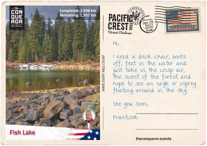
km od začátku : 2698
Fish Lake
The Cascade-Siskiyou National Monument is a forest reserve encompassing 114,000 acres established in 2000 by President Bill Clinton’s presidential proclamation and further expanded by President Barack Obama in 2017. It’s located at the junction of the Cascade Range and Siskiyou Mountains.
The Monument has a diverse ecosystem and it’s the first one in the US to be put aside for the preservation of biodiversity. It has a catalogue of at least 200 known bird species including the threatened Northern Spotted Owl and its water resource is critical to the salmon in the Klamath River. Flora such as Green’s Mariposa Lily and the critically endangered Gentner’s Fritillary are both endemic to the area. The much more widely distributed Blue Elderberry shrub can also be found here and its flower blossoms can be used to make tea whilst its fruit can be eaten.
As the trail winds its way past Keene Creek Reservoir and Little Hyatt Reservoir, I came across the 8 square miles (21 square km) catchment of Hyatt Reservoir. Dammed in 1923 the lake supports large population of fish and each year it is stocked with 250,000 young rainbow trout. With a shoreline of 7.5mi (12.1km) and a maximum depth of 38ft (12m), the lake is a recreational area with camping facilities and various activities including boating, fishing and wildlife watching.
Less than 3mi (4.8km) further is the even bigger Howard Prairie Lake with its 79 square mile (205 square km) catchment. Created in 1958 it is another recreational area with large numbers of trout and bass for anglers alongside hiking and cycling around the lake. Whilst surrounded by fir and pine the lake also consists of three islands: Buck, Doe, and Fawn.
I trekked through dense forest for another 15mi (24km) until I reached the southside of Brown Mountain. Skirting around the western foot of the mountain over solidified lava with sparse trees, the trail in this section finishes at Hwy 140 and the nearby Fish Lake.
Brown Mountain is a cinder cone at 7,344 feet (2,238 m) above sea level. Although the mountain seems reasonably young in age, it has been dated to 12-60 thousand years old. The solidified lava across the western slope that the PCT crosses is a result of an eruption 2000 years ago. It spewed enough lava to create a depth of over 250ft (75m). Whilst the base is covered in old growth forests, the summit is devoid of vegetation giving the visitor views of Mt McLoughlin to the north, Fish Lake to the northwest and Lake of the Woods to the east.
Fish Lake was initially a small natural lake until the Fish Lake Dam was built in 1898 to supply water to Rogue Valley. In early 1900s it was decided to connect the lake to Fourmile Lake for added water storage which is located diagonally across from Fish Lake with Mt McLoughlin in the middle of it. Constructing a canal in 1915, the two lakes were connected by bringing water from Fourmile Lake to Fish Lake. Today Fish Lake is a recreational area for trout fishing, boating and swimming.
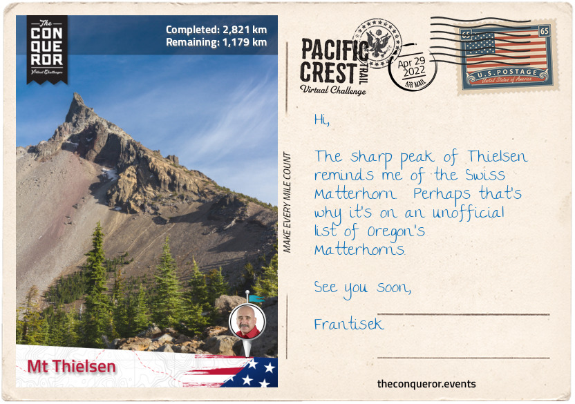
km od začátku : 2821
Mt Thielsen
Highway 140 runs between Brown Mountain and Mt McLoughlin with Fish Lake to the west of the two mountains. Crossing the highway, the trail climbs around the east flank of Mt McLoughlin and enters the Sky Lakes Wilderness area. At 9,493ft (2,893m) this dormant steep-sided volcanic mountain overshadows its neighbouring Brown Mountain. The mountain was named after John McLoughlin, a trader with the Hudson Bay Company who later ran a general store that was known as the last stop on the Oregon Trail.
To the north-east of McLoughlin is Fourmile Lake which is connected to Fish Lake via a canal. With a surface area of 483 acres and a depth of 170ft (52m), the lake is substantially larger than its neighbouring Fish Lake. The connecting canal allows excess water to be drained into Fish Lake for extra storage. Fourmile Lake sits within the Fremont-Winema National Forest. The forest is a merger of Fremont and Winema forests with a combined area of 2.25m acres.
Fremont National Forest was founded in 1908 with nearly 45% of its 1.2 million acres being old growth. There are two former uranium mines and a mining company within the forest which under federal law has been cleaned-up and restored. The forest was named after John C Fremont, an explorer, military officer and politician. Although controversy surrounded John Fremont’s army and political careers, as an explorer he was largely recognised as the man who opened the American west to immigrants and pioneers through detailed narrations of his expeditions, published maps and botanical records. He was often referred to as The Pathfinder. An enormous amount of places, organisations and plants are named after him.
Winema National Forest was founded in 1961 and of its 1.04 million acres, 68% of it is old growth. More than half of the forest was formerly an Indian Reservation of the Klamath people. When more than three-quarters of them voted to withdraw from the tribe, the US government purchased about 635,000 acres from the tribe and incorporated it along with three other national forests to form Winema National Forest.
The Sky Lakes Wilderness is one of four Wilderness areas within the Fremont-Winema National Forest. The Wilderness encompasses 116,300 acres and it has a staggering 200 pools of water of which a number of them are classed the “most chemically pure water known of all lakes in the world”. Two main basins within the Wilderness are: Sky Lakes Basin to the east of the PCT, below Luther Mountain and Seven Lakes Basin further along on the PCT to the west near Devil’s Peak. Sky Lakes is enriched with 14 lakes within its basin including the two larger ones, Marguerette and Trapper Lakes. Whereas the Seven Lakes has the extremely pristine Alta Lake that is so long and thin it could easily be mistaken for a river and Cliff Lake sitting directly below two peaks. A few of the Seven Lakes are visible from the summit of Devil’s Peak.
Although the trail takes a wide berth around Crater Lake it is worth noting that this amazing circular lake is visible from space. With a depth of 1,949ft (594m) it is the deepest lake in the United States. The lake is a result of Mount Mazama collapsing 7,700 years ago and forming a 2,148ft (655m) deep caldera. The lake is recognised for its deep blue colour and water clarity. The lake has two islands: Wizard Island and Phantom Ship.
The trail swings past Red Cone Peak, Grouse Hill Peak, the edge of Pumice Desert and ends at Mount Thielsen, a 290,000 year old extinct volcano. The steep slopes and horn-like peak of Mount Thielsen are a result of glaciers eroding its structure which during winter months become black diamond (advanced) skiing trails. When explorer Jon Hurlburt saw the mountain, he named it after Hans Thielsen, an engineer who was prominently involved in the construction of the California-Oregon Railroad.
km od začátku : 2887
Diamond Peak
Departing from the western flank of Mount Thielsen, the trail navigated north at above 7,000ft (2,134m), through Mount Thielsen Wilderness, down and over Windigo Pass and back up onto a ridge where I could enjoy views of Windigo Lakes below.
A few miles later the trail wound around the west side of Cowhorn Mountain. At 7,591ft (2,314m) the upper portion of the mountain was completely exposed and the hike to the summit a little challenging given the loose scree and scrambling needed to get to the top. However, the effort was worth it for the surrounding views and especially of Crescent Lake. Shaped like a crescent, hence the name, the lake has a surface area of 4,547 acres and a shore length of 12.4mi (20km). It is a natural lake with a dam located within Deschutes National Forest.
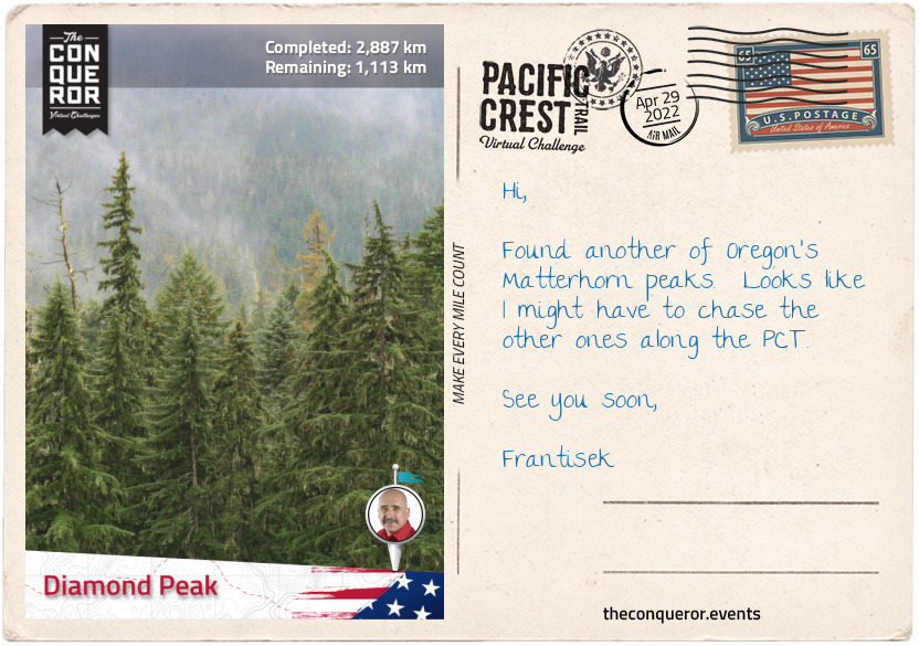
Continuing along the ridge through woodland and descending to 5,600ft (1,707m), the trail skirted the west end of Summit Lake for about a 1.5mi (2.4km), past several tarns to the base of Diamond Peak. Gradually climbing the trail ended on the eastern flank of the peak.
Diamond Peak is a 100,000 year old volcano that last erupted about 11,000 years ago. It has an elevation of 8,748ft (2,666m) with steep slopes and “andesitic volcanic cone that contains pyroclastic materials at its core”. Glaciers have eroded its slopes creating several cirques which are amphitheatre-like valleys. The mountain is located in the Diamond Peak Wilderness within the Deschutes and Willamette National Forests. It is surrounded by a coniferous forest.
Diamond Peak Wilderness has an area of 52,611 acres ranging from an elevation of 4,790-8,748ft (1,460-2,666m) of which Diamond Peak is the highest point. Three other peaks over 7,000ft (2,100m) are within the Wilderness: Mount Yoran, Lakeview Mountain and an unnamed peak. The vegetation is a combination of pine, firs and hemlock trees along with flowers such as mimulus, lupine, heather and Indian paintbrush. The forest is home to deer, elk, bears, foxes and squirrels, whilst ravens and woodpecker crows may be found in the sky with bufflehead and goldeneye ducks nesting near lakes.
Willamette National Forest was founded in 1933 when two forests were combined. Within its boundaries, the forest contains 8 wildernesses, 7 major peaks and several National Wild and Scenic Rivers. One-fifth of its area is designated as wilderness. The forest was at the centre of the controversy between the logging industry and environmentalists who worked at saving the endangered northern spotted owl. The resolution was to restrict logging in areas that could be spotted owl habitats.
Deschutes National Forest was established in 1908 from parts of three other forests and it contains 5 wildernesses, six National Wild and Scenic Rivers, a conservation area and recreation area. Of its 1.596 million acres about 20% is old growth and it has over 250 known caves.
km od začátku : 3016
McKenzie Pass
Skirting the eastern slope of Diamond Peak at around 7,200ft (2,194m) the trail descended and passed Odell Lake near Willamette Pass.
Odell Lake is a natural lake without a dam that fills a basin carved by a glacier. It has a surface area of 3,582 acres and shoreline of 13mi (21km). The lake was named after William H. Odell who was a surveyor general in Oregon. Various fish such as trout, salmon and whitefish can be found in the lake. The most significant catch was in 1984 when a trout weighing 40lb (18kg) was caught.
Although not visible from the PCT the nearby Waldo Lake is known for its exceptionally clear water which on a clear day can be seen to a depth of 120ft (36m). The lake was named after John B. Waldo, a judge who helped push preservation of the Cascades which eventually became a national forest in 1893. North of the lake is the Waldo Lake Wilderness.
Travelling through woodland, the trail emerges regularly at various lakes butting the PCT such as: Desane, S Lake, Mac, Horseshoe and Cliff Lakes, then through a meadow beside Ledge Lake. There’s an even longer list of lakes on either side of the PCT just out of view.
The trail then cuts through another meadow that from the air it looks like a ring-donut, with a circular collection of trees in the middle of the nearly round meadow.
Entering the Three Sisters Wilderness, the trail skirts around the west side of the Three Sisters, which are three closely spaced volcanic peaks named South, Middle & North Sisters, each over 10,000ft (3,000m) high. The peaks are the 3rd, 4th and 5th highest in Oregon and are prone to frequent snowfall and wild temperature variations between seasons.
Whilst North and Middle Sisters haven’t erupted in 14,000 years and are unlikely to ever again, South Sister’s last eruption was 2000 years ago and believed to very likely erupt again in the future. A tectonic uplift discovered in 2000 has increased monitoring of the peak.
Several glaciers can be found on the mountains but the beauty amongst all this is the highest lake in Oregon, known as Teardrop Pool, which can be found on South Sister’s summit crater.
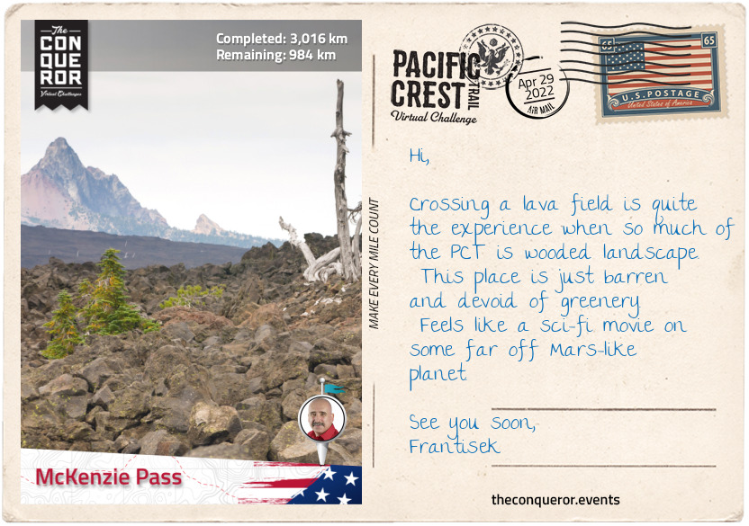
At the far end of North sister is the basalt covered Opie Dilldock Pass with a short, steep and angled climb to it. Descending slightly the trail forged on and skirted the foot of Yapoah Crater, a small cinder cone whose name translates as “isolated hill”. The hill is so barren, with the exception of a few specks of trees, that it almost looks polished with its fine basalt rock. It’s worthy of a climb to the top to see inside the smooth crater and take in the view of several prominent peaks.
Back on the trail, I finish this section at McKenzie Pass traversing solidified lava. Nearby is the Dee Wright Observatory, an open shelter structure made out of lava stones. The observatory is located in the middle of a lava flow and the viewing windows were designed to showcase and identify different peaks in the Cascades.
km od začátku : 3187
Mount Hood
A good 5mi (8km) was spent trekking over an old lava flow with its barren and grey terrain to the base of Mount Washington (7,795ft/2,376m). Another of Oregon’s Matterhorns due to its jagged peak, Mt Washington is a deeply eroded volcano that last erupted more than 250,000 years ago. The surrounding area is designated a wilderness but given the mountain’s extremely barren landscape it has very little wildlife and vegetation is mostly pine and shrubs. In 1926 a group of six boys were the first to scale the mountain to the summit.
Not far from the PCT is the very interesting flat-topped Hayrick Butte. Viewed from the sky the Butte takes on a near-perfect shape of a love heart. As a tuya, a type of subglacial volcano, Hayrick’s plateau of nearly half-a-mile (800m) across sits atop 700ft (210m) vertical walls. The north facing slope of Hayrick is rich in forestry, however, it seems to thin out towards the southern end of it with sparse trees and mostly meadows and shrubs in between. Although not as popular as the nearby Hoodoo Ski Resort, Hayrick’s summit offers views of the nearby Big Lake, Mount Washington, Mount Jefferson, Black Butte and its neighbour Hoodoo Butte.
Crossing Santiam Pass, the trail leads to Three Fingered Jack, a shield volcano that’s about 200,000 years old. At 7,844ft (2,391m) high, the mountain is inactive and highly eroded. It’s another peak within Oregon’s Matterhorn unofficial list. Skirting around its western slopes the trail climbs onto the north face with views of Canyon Creek Meadows to the east.
The trek from Three Fingered Jack covers a large section of open and barren terrain passing Wasco Lake, through Minto Pass, around Coyote Lake and to the base of Mount Jefferson and back into woodland.
The trail travels around the entire west side of Mount Jefferson which is about 10mi (16km) from the southside of the mountain to the northside. At 10,502ft (3,201m) high, Mt Jefferson is the second tallest mountain in Oregon. With incredibly rugged surrounds the mountain is difficult to access and hence highly regarded for mountaineering and backpacking excursions. The forest is a mix of fir, hemlock, pine and cedar trees. Formed about 730,000 years ago, the glacial erosion on the mountain seems to have carved a slice out of the western flank creating steep ridges and deep ravines in between.
Named after the 3rd President Thomas Jefferson (also famous author of the Declaration of Independence), the mountain is located in Warm Springs Indian Reservation to the east and Mount Jefferson Wilderness to the west. The Wilderness consists of 111,177 acres and a collection of over 150 lakes. A good 40mi (64km) of the PCT travels through the wilderness.
Trekking over a ridge at the north end of the mountain, the trail travels along the entire west side of Olallie Lake, a recreational lake and into Mount Hood National Forest, ending this section of the hike at Mount Hood.
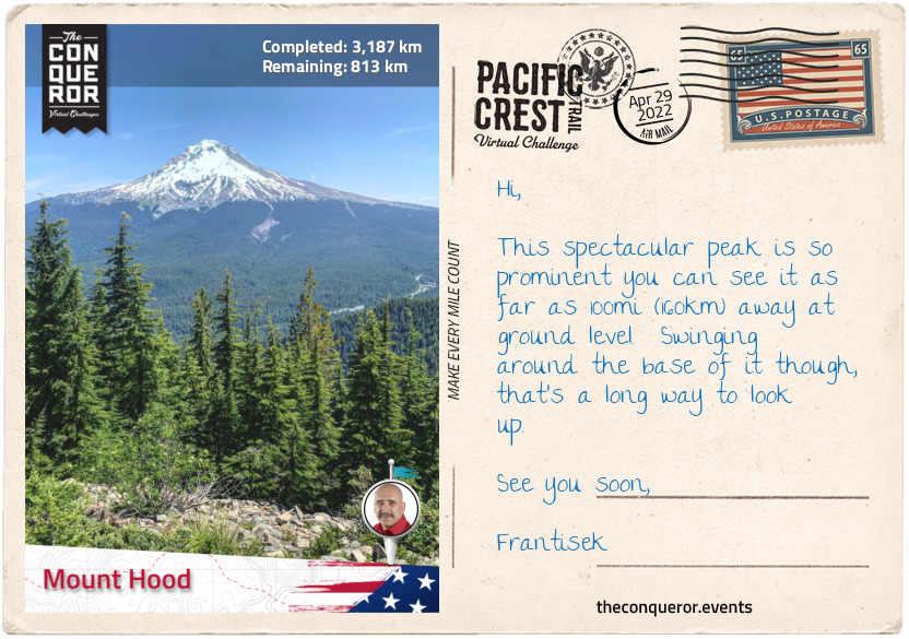
Mount Hood National Forest was first established under a different name in 1892 and changed to its current name in 1924. It has 8 designated wildernesses and of its 1.07 million acres, 32% are classed as old growth forest. The forest is one of the busiest in the US with a whopping 4 million visitors per year. Within its borders is Oregon’s tallest and most popular peak, Mount Hood at 11,249ft (3,429m).
Mount Hood is a dormant volcano with 12 named glaciers and 4,600 acres of skiable terrain. The mountain is estimated to be about 500,000 years old and its last major eruption was around 1865. First sighted in 1792, the name was bestowed by Lt William Broughton, a British naval officer, and named after Samuel Hood, a British Admiral at the Battle of the Chesapeake. Two US naval ships have been named after Mount Hood despite the namesake being of an enemy commander. First one was an ammunition ship in 1944 that was destroyed when its explosive cargo ignited and the second was another ammunition ship in 1971 that was decommissioned 28 years later.
A man-made feature just as significant at Mount Hood is the Timberline Lodge, a 70 room hotel located on the southern face only a few hundred feet from the PCT. Built during the Great Depression between 1936-38 the building was dedicated in 1937 by the 32nd President Franklin D. Roosevelt. What makes this building important is the handiwork of hundreds of artisans from stonemasons, blacksmiths and wood carvers to weavers. The interior of the building speaks volumes of the craftsmanship as wood carved animals adorn the stairwell, the drapes and carpets are handwoven, carved panels, mosaic murals, hand built furniture, wrought-iron gates, fire screens made of tyre-chains and a six-sided stone chimney stack 90ft (27m) high and 14ft (4m) in diameter. In 1977 the Lodge was designated a National Historic Landmark.
km od začátku : 3259
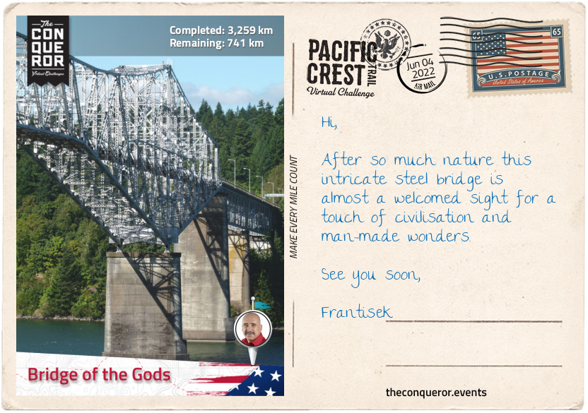
Bridge of the Gods
Traversing the southwest flank of Mount Hood, the trail dips down into Little Zig-Zag Canyon and back up, then 2mi (3.2km) further it fords Zig-Zag River between Zig-Zag Falls to the right and Middle Zig-Zag Falls to the left.
Zig-zagging away from Mount Hood through woodland atop a ridge, the trail wraps around Wahtum Lake. A recreational destination the lake is located in a cirque at 3,727ft (1,136m) and it is the deepest lake in Mount Hood’s National Forest at 184ft (56m).
The trail ascended towards the west end of Chinidere Mountain, but a detour off the PCT to the summit offered 360 degrees uninterrupted views of Mount Hook, Wahtum Lake below, the Columbia Gorge area and from as far as Mount Jefferson to the south to Mount Rainier in Washington State to the north.
Rejoining the PCT, the trail stayed on the ridge for the next 6mi (9.6km) before gradually descending out of the mountain area and into the city of Cascade Locks, alongside the Columbia River. With a population of 1,144 residents, Cascade Locks is the largest city directly on the PCT.
The city was named after a set of locks (canals) built in 1896 to help steamboats on the Columbia River to bypass the Cascade Rapids. It operated for 42 years when Bonneville Lock and Dam replaced it 4mi (6km) downstream. In 1938 the locks were submerged.
Columbia River is 1,243mi (2,000km) long and it is the largest river in the Pacific Northwest. The river starts in Canada’s Rocky Mountains flowing northwest before making a sharp turn to flow south through Washington state and then west for the last 309mi (497km) forming the boundary between Washington and Oregon states. The river empties in the Pacific Ocean, over the Columbia Bar, a shifting sandbar that makes navigating the mouth of the river extremely dangerous and is often referred to as the “Graveyard of Ships” due to the hundreds of nearby shipwrecks.
Crossing the Columbia River is via a steel truss, cantilever bridge named, Bridge of the Gods. When the bridge first opened in 1926 it was 1,127ft (344m) long, however, after the construction of the Bonneville Dam, the bridge needed to be raised 44ft (13m) and extended to the current length of 1,858ft (566m).
The bridge was named after a geologic feature of the same name which was a natural landslide that occurred sometime early in the first millennia (scientists have not been able to agree on an exact year). Named the Bonneville Slide, large amounts of debris from Table Mountain and Greenleaf Peak, both located on the northwest side of the river, tumbled into the river creating a natural dam and blocking Columbia River. The dam was about 200ft (61m) high and 3.5mi (5.6km) long. With the river impounded it created a lake so large that it drowned a forest for about 35mi (56km). Eventually the river broke through the dam and washed most of it away.
Standing on the bridge I dare not look down as the roadbed is not asphalt but an open metal grate with views of the mighty Columbia River rushing below. The bridge is also barely two-lanes wide with no sidewalk for pedestrians. Hikers cross at their own risk and pay a toll for the privilege. However, here in the middle of the bridge I am at the lowest elevation point on the PCT. A mere 170ft (50m) above sea level. Crossing the remainder of the bridge I farewell Oregon and welcome Washington.
A sidenote - many hikers take the alternate Eagle Creek Trail from the PCT for the last 14mi (22km) into Cascade Locks for all the waterfalls this route offers. The trail is squeezed between narrow canyons and on one occasion it even travels behind a waterfall. A total of ten waterfalls are accessible via this route including the spectacular Punch Bowl Falls which plunges 35ft (11m) into a large bowl that resembles a punchbowl, hence the name.
km od začátku : 3464
Leech Lake
Washington state starts with a plethora of lakes just across the Bridge of Gods. As the trail turns west, the PCT passes Ice House Lake and whilst no other lake is visible there is a fair collection beyond the woods next to each other with Wauna Lake as the largest, neighboured by Black, Evergreen and Fern Lakes.
The trail travels through woodland untill it circles around Gillette Lake and the west flank of Table Mountain which together with nearby Greenleaf Peak are responsible for shearing off their south face and damming Columbia River 600-800 years ago.
This section of the trail is entirely within the Gifford Pinchot National Forest. One of the oldest forests in the United States. It runs from Columbia River at the Washington-Oregon border to Mount Rainier National Park in the north. It encompasses 1,312,000 acres consisting of several wildernesses, numerous major rivers, lakes and various peaks. The forest was named after Gifford Pinchot, a forester and politician who was friends with Theodore Roosevelt and together convinced Congress to establish the US Forest Service.
The PCT travels through four wildernesses, of which three are connected to each other and all within this particular section. Indian Heaven is the first one which encompasses 20,782 acres of forested plateau and about 150 small lakes. The second one is Mount Adams Wilderness which is home to the west side of Mount Adams and its peak (the east side is part of the Yakama Nation territory). The third wilderness is Goat Rocks at the north end of this section across both Gifford-Pinchot forest and Okanagan–Wenatchee National Forest.
Mount Adams is 12,276ft (3,743m) tall and it is the highest peak in the Gifford-Pinchot forest and second highest peak in the state. It is a very large, broad mountain with a diameter base of 18mi (29km). Although it’s a volcanic mountain and its last eruption was 920AD, today it is still considered active. It has 12 named glaciers of which Adams Glacier is the second largest in the Cascades. It is a climber’s paradise with 25 different routes ranging in level of difficulty. The easiest non-technical route is from the south, whereas the north and west are a game changer with their steep headwalls, where crampons and ice axes are generally required. However, the relatively flat summit affords amazing panoramic views of at least nine other volcanic peaks, including St Helens, Jefferson, Rainier, Hood, Three Sisters and Baker. The mountain was named after 2nd President John Adams, one of the founding fathers of the United States, a leader of the American Revolution and contributor in the drafting of the Declaration of Independence. The PCT traverses the western flank of the mountain.
Trekking onto Goat Rocks Wilderness, the trail travels up and down along the western slopes of Goat Rocks, an extinct volcano which features several rugged peaks such as Gilbert, Ives, Old Snowy, Tieton, Johnson, Bear Creek and Hogback. It was named after the numerous goats that are found in the area. Various mineral resources can be found on Goat Rocks, such as coal, copper and lead.
Whilst each peak is moderately tall, the highest is Gilbert Peak at 8,202ft (2,500m). Gilbert Peak has two glaciers: Meade Glacier to the south and Conrad Glacier to the east. McCall Glacier is located to the east between Ives Peak and Snowy Mountain. The trail then crosses Packwood Glacier, northwest of Snowy Mountain, up onto a ridge until it descends northeast into woodland through Tieton Pass. Another ascent up the southwest slope of Hogback Mountain and over to traverse most of the barren, east flank of the mountain, back into the woods and down to Leech Lake.
Located at the summit of White Pass, within Wenatchee National Forest, Leech Lake is a fly-fishing-only lake. It has 1.5mi (2.4km) loop trail around the lake which is accessible year round either for hiking or snowshoeing.
km od začátku : 3611
The Summit at Snoqualmie
Heading north in Wenatchee National Forest the trail passes several lakes and through a broad valley with Fryingpan Mountain to the left. The Wenatchee Forest has six wilderness areas of which three are traversed by the PCT being: William O. Douglas, Henry M. Jackson and Goat Rocks which was in the previous section.
Crossing Bumping River near Fish Lake, the trail starts a steep 250m ascent through several switchbacks passing Buck Lake to the right, Crag Lake further up to the left with Crag Mountain peak on the opposite side. For several miles the trail weaves between Mount Rainier National Park and Wenatchee National Forest. It passes the nearby Anderson Lake then the PCT crosses a stream that connects the large Dewey Lake on the right to a small unnamed lake on the left.
Climbing up over a crest the trail skirts the foot of Naches Peak to the east, then alongside Hwy 410 before veering off and climbing past Sheep Lake and over Sourdough Gap. Trekking on the side of a ridge the trail reaches Brown Gap within the Mt Baker-Snoqualmie National Forest and the Norse Peak Wilderness. The Gap is the midpoint of a mountain range shaped like a horseshoe. The trail heads right past Pickhandle and Crown Points, with views of Crystal Mountain Ski Resort on the opposite side. The carved ski trails are prominent as they weave down the mountain funnelling at the bottom near the ski lifts.
Mt Baker National Forest was established in 1907 and Snoqualmie National Forest in 1908. They were combined as one in 1974. Together they encompass 1,724,229 acres and nearly half is designated wilderness with a total of 10 separate wilderness areas. Almost 42% of the overall forest is old-growth. The forest is home to the largest number of glaciers outside of Alaska. As at 1998 count there were a total of 287 glaciers within the forest. Due to warming conditions many glaciers have disappeared prior to this count consequently warming rivers and reducing their flow. This in turn affects fish species that rely on this ecosystem.
Travelling through Norse Peak Wilderness, the trail flanks east of Norse Peak through Green Pass and across the ridge of Blowout Mountain. From here the trail commences a long and steady descent from 5,698ft (1,737m) passing Snowshoe Butte, Mirror Lake, Silver Peak and ending at The Summit at Snoqualmie at 3,200ft (975m).
Snowqualmie is a ski resort with a skiable area of 1,994 acres. The resort has 62 runs of various levels across 4 different areas. Of its 62 runs more than half are advanced or expert ski runs and its longest run is 1.2mi (1.9km) long. The PCT runs along the west side of the Summit, whereas most of the ski runs are on the east side. Only the last half a mile (800m) of the trail is traversed beneath the ski lifts and over the ski runs.
km od začátku : 3714
Stevens Pass
Taking the underpass beneath the I-90, the next 7mi (11km) was an upward climb to the ridge gaining 2,600ft (792m) to Kendall Katwalk. I circled the ridge with Alaska Lake below, crossed over a crest to circle another ridge with Joe Lake below to the right and Edds Lake to the left.
The trail traverses the southern and eastern flank of Huckleberry Mountain with its sharp peak (6,320ft/1,930m) and treks over a crest to traverse the southwest flank of Chikawee Mountain (7,000ft/2,100m) and its neighbour Four Brothers (6,489ft/1,978m).
The three peaks are within the Alpine Lakes Wilderness. Encompassing 394,000 acres the wilderness is home to woodland consisting of firs, cedar, pine and hemlock to expansive meadows and more than 700 lakes that dot the glacier carved terrain the PCT travels through.
Crossing a crest the trail descends into a wide valley before starting an upward climb on tight switchbacks and continues zig-zagging until it goes down again, gaining and losing about 2,297ft (700m) then a straight stretch to Waptus Lake. Trekking the full length of the lake, the trail swings left into a canyon alongside Spinola Creek which empties into nearby Deep Lake, then up a handful of switchbacks to Cathedral Pass and the east side of Cathedral Rock.
Traversing a valley the trail passed the full length of Daisy Lake and its north-westerly neighbour Deception Lake. I wound my way up the west side of Surprise Mountain (6,330ft/1,930m) to its north face and then back down northeast passing Glacier Lake, then crossing the terrain diagonally to climb back over another crest and traverse the flank of a mountain slope with Trap Lake below.
Moving north-easterly, the trail passes next to several more lakes such as Hope, Mig and Josephine Lakes and straight through Stevens Pass Ski Area crossing the saddle between Cowboy Mountain (5,845ft/1,782m) to the left and Big Chief Mountain (5,600ft/1,600m) to the right.
Stevens Pass has 1,125 acres of skiable terrain that includes 37 ski runs. The area around it is prone to avalanches and it bears the mark of the worst avalanche in US history. In 1910, the small community of Wellington experienced nine consecutive days of severed blizzard, with snow of up to a foot (30cm) falling every hour and on the worst day 11ft (3.4m). Two trains were trapped in the depot, one of them a passenger train with all the passengers and crew staying aboard. Due to lightning strike, a slab of snow broke loose that was 10ft (3m) high, half-mile (800m) long and quarter-mile (400m) wide and tumbled toward town. With a recent fire ravaging the slopes the avalanche had complete freefall with nothing standing in its way. It hit the trains in the depot and tossed the trains 150ft (45m) downhill into the valley. A total of 96 people died in the wreckage and 23 survived. The town was renamed to Tye to remove the stigma of the previous name. When the Cascade Tunnel finished construction in 1929 the town was eventually abandoned.
km od začátku : 3893
Rainy Pass
About 2.8mi (4.5km) from Stevens Pass, the trail circles Lake Valhalla and rising steeply above this glacial lake to the east is the rugged peak of Lichtenberg Mountain (5,844ft/1,781m). The west side of Lichtenberg is a much gentler slope with Lichtenwasser Lake at the base.
Trekking over Union Gap the trail descends into a valley to Janus Lake. This body of water is only 40ft (12m) deep at its centre and it sits at the base of Jove Peak (6,007ft/1,839m). The lake was named after the two-faced Roman God because it was thought that the lake drained west as shown on maps but it actually drained east. The peak was named after Jupiter, Jove for short, the Roman God of sky and thunder. Both the peak and the lake were named by Albert Hales Sylvester, associating it to the nearby features that were also named after Roman Gods, ie Minotaur & Theseus Lake and Labyrinth Mountain.
Albert himself was a fascinating character. As a pioneer surveyor, explorer and forest supervisor in the later 19th century, Albert was largely responsible for naming more than 1,000 features in Washington state. Together with Gifford Pinchot they recognised that naming features and producing detailed maps was an important task in order to protect forests from wildfires. Through the naming process it made it easier to provide the correct location of fires to the firefighters. With so many features unnamed, Albert took it upon himself to explore, map and name the natural features. He was often the first to climb these peaks as part of his surveying work.
The trail continues over a crest and follows along on a ridge through Wenatchee Pass to Pear Lake and Fortune Mountain (7,382ft/2,250m) behind it. The peak was named after Fortune Creek which is where Queen of the Hills gold mine and Ruby Mine were located.
The trail then traverses the east slope of Skykomish Peak (6,368ft/1,941m) located within the Henry M. Jackson Wilderness. The volcanic ash found on Skykomish is a result of the nearby volcanic Glacier Peak. Creating fertile soil the slopes of Skykomish are filled with wildflowers and meadows.
The wilderness itself consists of 103,297 acres and it is “rich in mining history with several acres of patented mining claims within its borders.” There are 30 lakes within the wilderness with the most striking being Blanca Lake due to its turquoise green color, a result of silt-filled melt water. With a combination of tall forest and broad meadow, the wilderness has a mix of cedar, firs, spruce, hemlock and at higher elevations, alpine meadows.
Tucked in a cirque along the PCT is Lake Sally Ann looking mighty inviting for a dip. Pushing on though the trail reached Kodak Peak through its southside, along its eastern ridge and then traversing its eastern flank through Indian Pass. As the name suggests Kodak Peak offers wonderful views of the surrounding area, particularly the dominating Glacier Peak to the northeast and some of the smaller ones such as, White Mountain to the north and Johnson Mountain to the west.
Trekking between White Mountain, Portal Peak and White Chuck Cinder Cone, all in close proximity, the trail descends 2,296ft (700m) into a densely forested valley at the base of Glacier Peak within the Glacier Peak Wilderness. The peak at 10,525ft (3,207m) is one of five stratovolcanoes and fourth tallest peak within the state. Formed a million years ago, Glacier Peak is one of the most active volcanoes having explosively erupted at least five times in the last 3,000 years. There are 11 significant glaciers on the peak.
Circling the north side of the peak, then on the flanks of Vista Ridge, the trail crosses Suiattle River. Sometime in 2003 a flood washed away the original bridge leaving the PCT without any safe crossing. It wasn’t until 2011 that a new bridge was installed. Until then a large tree trunk that fell across the river was used as a makeshift bridge. Crossing it standing up was dangerous with no railings to rely on, so straddling the trunk and scooching across was the favoured method.
The trail follows the river for 4mi (6.5km) and then turns left to wind its way on the slopes of Plummer Mountain and its neighbour Sitting Bull Mountain. Descending into a valley and alongside South Fork Agnes Creek the trail is flanked by the rising peaks of Needle Peak, Saddle Bow Mountain and Agnes Mountain. The creek joins Agnes Creek in the aptly named Agnes Gorge where the trail follows alongside it to the base of McGregor Mountain where it forks off. Agness Creek travels right joining Stehekin River. Taking the left fork along the continuation of Stehekin River, the trail carries on until it turns right alongside Bridge Creek, past Rainy Lake and terminates at Rainy Pass, a mountain pass on State Route 20.
Although not on the PCT an interesting feature east of McGregor Mountain is Lake Chelan. This incredibly narrow and very long lake looks like a very wide river when seen from a satellite. It has a shoreline of 109mi (175km), length of 50mi (81km) and a depth of 1,486ft (4539m). It’s total water volume is a staggering 15,800,000 acre feet.
km od začátku : 4000
Manning Park, Canada
From Rainy Pass, I crossed the road and entered the valley along Porcupine Creek and Porcupine Peak to my left. Climbing a few switchbacks, the trail traversed the south end of Tower Mountain, a non-volcanic mountain with prominent jagged peaks, then over a crest and down into a valley beside Methow River for the next 5mi (8km).
Turning left at Azurite Peak, the trail ascended and traversed the south slope of Tatie Peak. I left the PCT for a quick scramble to the summit for a complete view of the North Cascades. Back on the PCT, I followed the trail across the flank of Slate Peak, then down to the foot of Tamarack Peak and up the east slope of Devil’s Backbone.
After descending into Holman Pass, I ascended again weaving between Holman Peak, Powder Mountain and Three Fools Peak towards Lakeview Ridge and reaching the ridge of Devil’s Stairway (6,800ft/2,073m). Circling along the ridge, I was enjoying the near perfect circular Hopkins Lake below. Once I trekked through Hopkins Pass, the trail descended to 6,000ft (1,829m) and traversed the western slope of Blizzard Peak, then further descending to 5,200ft (1,585m) as it passed the west side of Mt Winthrop for the next 3mi (4.8km) to the Canadian border.
Entering the province of British Columbia, I travelled through the valley to Windy Joe Mountain and completed the final stretch by crossing Similkameen River and ending this most extraordinary journey in Manning Park at an elevation of 3,937ft (1,200m).
It would have been impossible to capture all the peaks, passes, gaps and lakes throughout these writings but it does raise the curiousity that is perhaps best illustrated in a statistical roundup:
Clinton Clarke, the “Father of the PCT”, was an avid hiker and great visionary when in 1932 he proposed the idea of creating a wilderness trail from Mexico to Canada, along the crest of the Pacific Coast mountains for the preservation and protection of its wilderness from human interference. It would take 61 years before the Pacific Crest Trail was officially completed. As he beautifully encapsulated the meaning of the PCT in these words, he left a masterpiece to be enjoyed for generations to come.
“In few regions of the world … are found such a varied and priceless collection of the sculptured masterpieces of Nature as adorn, strung like pearls, the mountain ranges of Washington, Oregon and California. The Pacific Crest Trail is the cord that binds this necklace.”
- Clinton C. Clarke, Pacific Crest Trailway Compilation, 1945