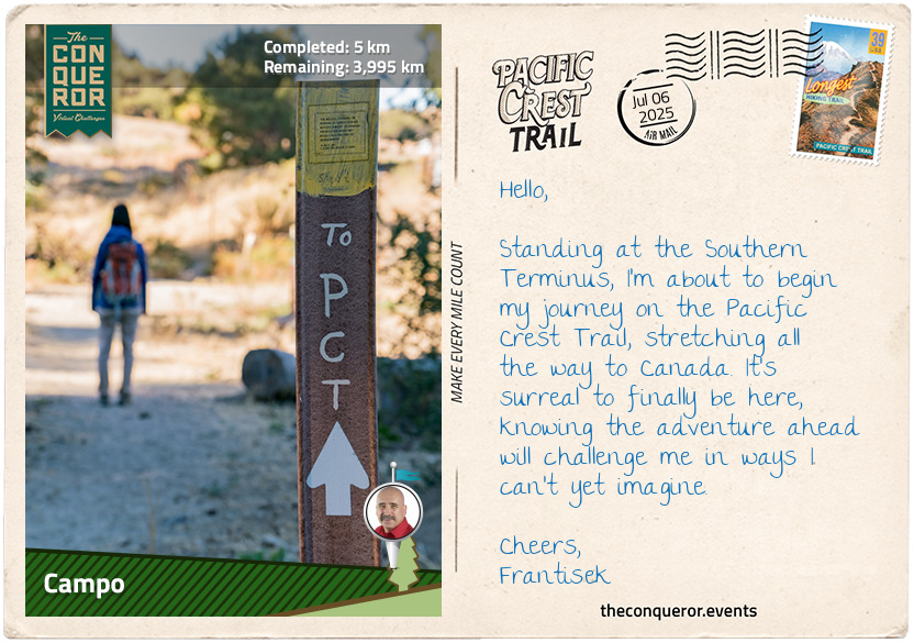
Standing at the Southern Terminus of the Pacific Crest Trail (PCT) in Campo, California, I take a deep breath. The desert air is warm, the landscape dry and rugged, stretching endlessly toward the horizon. This is it—the start of a journey stretching 2,650mi (4,265km) from the U.S.-Mexico border to Canada. The PCT is one of America's great long-distance trails, part of the Triple Crown of Hiking alongside the Appalachian and Continental Divide Trails. It winds through deserts, forests, and mountains, crossing 25 national forests and seven national parks. Along the way, I'll climb to 13,153ft (4,009m) at its highest point and push through landscapes that most people only ever see in photographs.
Campo, where it all begins, is a quiet little town with a deep history. During World War II, it was a military base, but before that, it was home to the Buffalo Soldiers—an all-Black regiment formed in 1866, many of whom became the first national park rangers in California's Sierra Nevada. The oldest known Buffalo Soldier, Mark Matthews, joined the regiment at just 15 years old in 1909 and lived to be 111. The town is also known for the Pacific Southwest Railway Museum, where old locomotives and railway signals tell stories of another era. But today, my focus isn't on history—it's on the journey ahead.
The Southern Terminus, marked by five wooden pillars standing next to the border wall, is about 1.5mi (2.4km) south of Campo. The pillars were first placed here in 1988, marking the start of this epic trail. With the desert stretching ahead, the enormity of what I'm about to do slowly sinks in, and I suddenly feel the need to check my gear just one more time. My essentials include a custom-fitted, sturdy backpack, lightweight tent, warm sleeping bag, map and water filter. My food resupplies are carefully planned, with stops in trail towns where I can grab a hot meal and some extra snacks. Water sources will be scarce in certain sections, especially in the desert, so staying hydrated will be a top priority.
I plan to thru-hike in about five months, averaging 15mi (24km) per day, assuming reasonable and preferably snow-free mountain conditions. The first stretch through the Southern California desert will be gruelling—hot days, cold nights, and long distances between water sources. Then come the towering Sierra Nevada peaks, where possible snow and altitude will bring different challenges. Once I enter Oregon, it should offer some relief with its flatter terrain and enough recovery to tackle Washington with its rugged climbs and unpredictable weather.
Through it all, I know I won't be alone, as I'll meet hikers from all walks of life, each with their own reason for taking on this journey. Some will thru-hike like me, while others will tackle the trail in sections. Trail angels, kind strangers who leave water, food, or even offer a place to rest, will remind me that this journey isn't just about the miles but about connection. And since there's no way to predict what this experience will bring, I am ready to embrace the challenges, the exhaustion, and the unknown—while reminding myself to appreciate every moment and keep a sense of wonder.
Right now, Canada feels impossibly far away, but I'll take it one step at a time, embracing every sunrise, every challenge, and every quiet night under the stars.
My boots are laced, my pack is ready, and the trail is calling. Time to go.
km od začátku : 0167
Warner Springs
Leaving Campo behind, I noticed the landscape shift as the trail led me through Lake Morena County Park, a peaceful spot for camping, fishing, and hiking. Its mix of desert, coastal, and mountain habitats made it a wildlife haven. Western bluebirds flitted through the trees, and bald eagles soared overhead. I kept my eyes peeled for bobcats, hoping to glimpse one among the shrubs. I'd also heard striped skunks could appear here, but given their less-than-appealing aroma, I was happy to avoid crossing paths with one.
As the trail continued, it swung beneath Interstate 8 at Boulder Oaks, where the sounds of the highway faded, and the path wound its way toward the Laguna Mountains. The climb began in earnest here, with the air cooling as I gained elevation. Reaching the peak of Mount Laguna, I was greeted by towering Jeffrey pines stretching high into the sky. The small town of Mount Laguna had fewer than 100 residents, but the general store offered a welcome chance to grab some snacks before continuing.
Skirting around Monument and Garnet Peaks, I followed the trail as it briefly ran alongside County Highway S1. Monument Peak opened to sweeping views of the Anza-Borrego Desert, while Garnet Peak stood out with its steep, rocky terrain. There's a separate trail leading up to its summit, short but tough, with loose gravel and a steep incline. The views from the top are said to be incredible, though I chose to keep going as the wind picked up. The path then veered toward Granite Mountain, its rugged slopes dotted with massive boulders.
Eventually, I reached Highway S2, the Great Southern Overland Stage Route, once followed by pioneers heading to California during the Gold Rush. It was humbling to walk in their footsteps, imagining their long, treacherous journey across this arid land. My hike, challenging as it was, felt like a luxury in comparison.
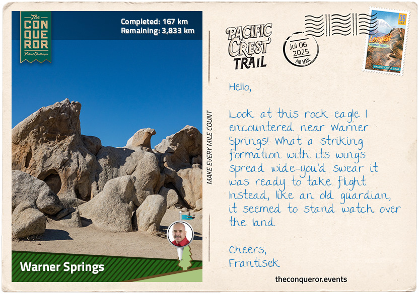
As I neared Warner Springs, I came across Eagle Rock, a stunning natural formation of giant boulders shaped like an eagle. The trail wound through grassy fields and thick groves of oak trees before arriving in town. Warner Springs, originally home to the Cupeno people, saw Spanish missionaries arrive in 1818, and by 1830, the St. Francis of Assisi Chapel was established, still holding services today. Nearby, the Warner Ranch House, built in 1849, served as a way station for emigrants on the Southern Emigrant Trail. The history of the place is heavy, especially the story of Juan Jose Warner, a fur trader turned rancher, and the tragic relocation of the Cupeno people in 1903.
km od začátku : 0323
Whitewater
Crossing Highway 79 from Warner Springs, I step onto the trail, feeling the familiar crunch of dirt and rock beneath my boots. The path winds and climbs steadily, leading me east of Coombs Peak. The thought of a short quarter-mile side trek to the summit tempts me, but I know it won't be easy—the loose rocks and steep grade demand attention. I press on, rewarded with sweeping views of the shimmering Salton Sea to the east, the calm expanse of Lake Henshaw to the southwest, and the towering silhouettes of San Jacinto and San Gorgonio to the north. The climb is worth every effort.
The trail meanders through rolling terrain, crossing a few dusty dirt roads before reaching Highway 74. To the west lies the Cahuilla Reservation, and to the east, the Santa Rosa Reservation—both home to the Cahuilla people. Passing through this land, I think about its history, the echoes of those who lived here long before my footsteps joined the trail. The town of Anza, just beyond, carries the name of Juan Bautista de Anza, the Spanish officer who once led expeditions into this rugged territory.
Beyond Highway 74, the trail begins its ascent onto the San Jacinto Mountain Range. The switchbacks come in quick succession, each turn revealing a new layer of the landscape. Pine Mountain Ridge rises to my right, its stubborn sandstone layers holding firm against time. The lower slopes are blanketed in chaparral, but as I climb higher, the air turns crisp, and the scent of pine and incense cedar fills my lungs. The steady exertion of the climb is softened by the beauty surrounding me.
Staying high along San Jacinto's ridgeline, I navigate the rugged terrain of the San Bernardino National Forest, passing peaks that soar beyond 7,000ft (2,100m), like Palm View Peak, Spitler Peak, Apache Peak, and the jagged Antsell Rock. When I finally reach Tahquitz Peak at nearly 8,800ft (2,680m), I pause, catching my breath and taking in the vast, untamed wilderness stretching below. The elevation is steadily gaining, and I can feel the air thinning the further up I hike, a subtle reminder that altitude sickness isn't uncommon here.
I descend through Saddle Junction and veer westward into Mount San Jacinto State Park. The towering peaks around me, some soaring over 10,000ft (3,048m), including San Jacinto, the tallest peak, are a wondrous sight. Encountering snowy conditions would not be unusual here, and being prepared with an ice axe, crampons, and snow travel skills would be essential. As I feel the crisp bite of the higher altitude, I am grateful that I don't need to deal with any snow and can move more freely through this rugged terrain.
One of the highlights ahead is the Palm Springs Aerial Tramway, a marvel of engineering that whisks visitors from the desert floor to an alpine wonderland in just over 12 minutes. I stick to the trail, knowing my descent is near.
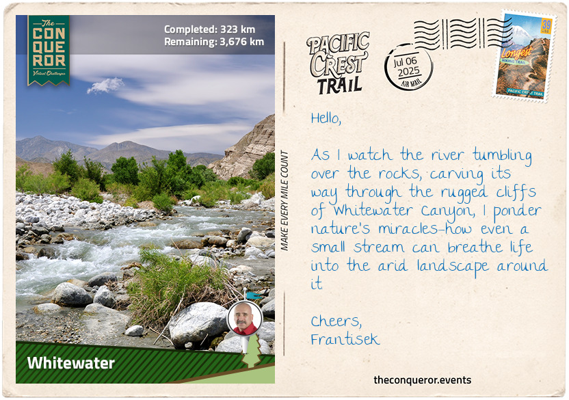
Reaching Fuller Ridge, the trail plunges downward in tight switchbacks into Snow Creek, a remote valley village. As I cross Interstate 10 into Whitewater, I imagine the weary travellers in the mid-19th century stopping here for a rest, much like I am now, before continuing their journey across the desert in search of fortune.
km od začátku : 0526
Crowder Canyon
Returning to the trail and gradually ascending, I hiked deeper into the wilds of Whitewater Canyon. Carved by the Whitewater River from the San Bernardino Mountains, the canyon was raw and untamed. It was hard to believe that this rugged gorge had once been overrun with cattle, the river murky and neglected. As I watched the crystal-clear water flow by, it felt like a small miracle, a result of tireless efforts from the Conservancy Association, who had worked to restore the wilderness by removing non-native diseased trees, demolishing abandoned structures, and retiring grazing cattle. The wildlife here, from bighorn sheep to the occasional black bear, seemed to thrive in this untouched land. I paused by the river, letting the cool air wash over me, soaking in the serenity of a place preserved for generations.
The trail ahead beckoned, narrowing as it wound its way through a rocky pass, and I felt a growing sense of anticipation. As I moved north, each step became harder, my legs protesting the steady climb. Yet, the promise of reaching Big Bear Lake kept me going. I could feel the crisp mountain air as I neared the high-altitude town. Big Bear—its name alone filled me with a sense of adventure. I smiled at the thought of the Hollywood magic created here, with scenes from classic movies like Gone With the Wind, Daniel Boone, and Paint Your Wagon filmed in the area. I could imagine the Hollywood legends walking the same trails.
After crossing Delamar Mountain, the trail twisted and turned, leading me toward Deep Creek. The sound of rushing water filled my ears as I neared Aztec Falls, a small cascade that fed into a deep, inviting pool. The heat from the sun pressed down on me, and the temptation to dive in was almost unbearable. But I pushed forward, knowing that something better was ahead. For the next 15mi (24km), Deep Creek was my constant companion, the rhythmic flow of its waters providing a comforting backdrop to my hike.
When I finally arrived at Deep Creek Hot Springs, I couldn't wait to slip into the warm, mineral-rich waters. The soothing heat relaxed my aching muscles, and for a moment, I simply let go. I closed my eyes, letting the warmth seep in, feeling utterly content. It was one of those rare moments when everything fell into place, and the miles I'd walked were completely worth it.
Refreshed and renewed, I followed the creek until it eventually veered off, leading me toward Silverwood Lake. The cool, glassy water was a welcome sight, especially after another lengthy, dusty trek. The creation of the lake, brought about by the construction of the Cedar Springs Dam in 1971, led to the flooding of the town of Cedar Springs. Residents were forced to relocate as the dam created the reservoir, submerging their homes and the surrounding land. On the positive side, it provided much-needed water resources to the region.
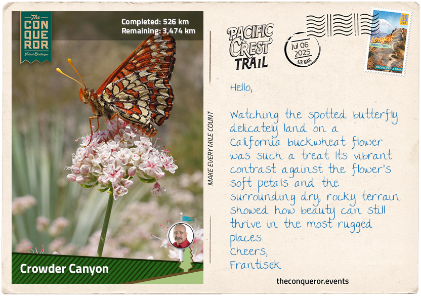
Another 15mi (24km) later, I reached Crowder Canyon near Interstate 15. It struck me that 19th-century traders had once travelled this very route, linking Santa Fe to Los Angeles on a gruelling 700mi (1,100km) journey. Following in their footsteps, I crossed beneath the Interstate, leaving the San Bernardino National Forest behind me. Ahead lay the Angeles National Forest, a new chapter in my journey, and I felt a flicker of excitement at the thought of what was to come.
km od začátku : 0697
Aqua Duke
The Angeles National Forest has been a part of California's landscape since 1908, stretching across the San Gabriel and Sierra Pelona Mountains. As I set off on this stretch of the PCT, I know I have a good 100mi (160km) ahead of me, weaving through these mountains, climbing ridges, and descending into valleys, all with Los Angeles just beyond the horizon. It's strange to think that just north of one of the busiest cities in the world, this vast wilderness remains untouched, protected under the Wilderness Act. Here, I am merely a visitor passing through, aware that the forest and its wild inhabitants—black bears, cougars, and rattlesnakes—have called this place home long before me.
The landscape changes as I go, with chaparral shrubs dominating the lower elevations, giving way to oak woodlands, coulter pines, Douglas fir, and California walnut. The trail is rugged, and I feel the weight of my pack pressing on my shoulders as I climb toward the high ridges of the San Gabriels. Each ascent intensifies, with my quads burning and calves twitching with every step I take. Looking up, I am rewarded with sprawling views of the city behind me and the Mojave Desert stretching endlessly ahead, its vastness framed by the San Andreas Fault. The effort is intense, but the sprawling scenery makes it worthwhile.
A few of the mountains I pass stand out. Mount Baden-Powell, named after the founder of the World Scouting Movement, is just a short detour from the PCT. Mount Burnham honours a military scout who influenced Baden-Powell's teachings. Then there's Mount Disappointment, with its unfortunate name. Surveyors once believed it to be the highest peak in the area, only to be let down when San Gabriel Peak proved taller. History lingers here, even on South Mount Hawkins, where a fire lookout tower once stood for 67 years before it was claimed by a wildfire.
To my right, I catch glimpses of the Mountain High Ski Resort that has welcomed skiers since 1937. It's hard to imagine now, under the summer sun, but this place comes alive in winter with skiers carving down the slopes. Can you believe that a ski ticket here once cost just $1.50?
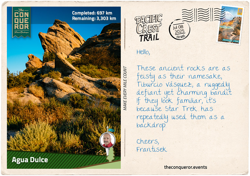
The trail eventually descends, crossing Soledad Canyon Road and the Santa Clara River. The final 10mi (16km) led me into Agua Dulce, a small town in the Sierra Pelona Valley. Just outside of town, the Vasquez Rocks rise dramatically from the earth due to seismic uplift. They're a familiar sight, having appeared in countless films, but they hold a deeper history as a hideout for the legendary bandit Tiburcio Vasquez.
As I settle in for the night, I pitch my tent and slip off my boots, and the cool air on my feet is a welcome relief. After assessing my boots' integrity for support and cushioning, I give my legs and feet a good rubdown to work out the aches. I pull out a dehydrated meal of savoury beef stew. I added boiling water to the pouch and waited for it to rehydrate. As I take that first bite, the warmth and comfort settle in, and for a split moment, the day's effort fades away. The quiet of the wilderness surrounds me, bringing with it a sense of calm and tranquility.
km od začátku : 0877
Tehachapi Pass
Waking up from a deep sleep, I popped out of my tent to see that the sun had already begun peering through the trees. I stretched, feeling the stiffness in my legs from the day before, and then brewed myself a strong cup of coffee. The morning air was crisp, and the warmth from the coffee seeped into me, giving me the jolt I needed. Breakfast was simple — a mix of oats and peanut butter, enough to fuel me for a few hours. Packing my tent, I checked that all was in place and readied for the day's hike.
As I gathered my things, I was glad to see that my food was safe. I'd hung it using the recommended bear canisters and the hanging method, and everything remained untouched. It felt like a small victory after the effort of getting it all sorted. These precautions are necessary on the trail because, in areas like this, wildlife is always on the lookout for food. Bears, in particular, are quite clever and known to get bold, often trying to access unprotected food. Using a canister and hanging food high on a tree branch is the best way to avoid this. It protects my food and ensures that the bears' natural behaviour remains intact, preventing them from becoming reliant on human food.
With my pack secured, I set off. The trail quickly entered the brushy expanse of Sierra Pelona, a mountain ridge bordering the San Andreas Fault to the north, with the wide Soledad Canyon separating it from the San Gabriel Mountains. The climb began almost immediately, my calves protesting as I gained elevation. The scent of dry earth and chaparral filled the air, while yucca plants thrived in the harsh desert climate, their deep roots reaching underground for moisture.
As I continued, I moved into the vast expanse of Antelope Valley, where the Mojave Desert seemed to stretch forever. This section of the trail followed the Los Angeles Aqueduct for miles, a long, covered concrete channel snaking through the barren land. Hiking beside it was both surreal and exhausting. This critical waterway, bringing life to millions, cut through one of the driest stretches of the trail. The path here was relentless, exposed, and hot, with little shade from the sun's intensity. Hikers before me had warned of the challenge, expecting long miles over cracked earth, with only the occasional breeze to offer relief.
Despite the harshness, life still thrived. I spotted mule deer grazing, hawks circling overhead, and, in a burst of colour, a Steller's jay darted through the trees, its blue feathers vivid against the desert's muted tones.
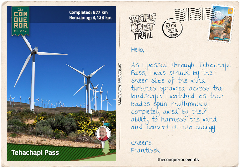
After the woodlands of Sierra Pelona, the trail heads north for a hot, dry hike across the San Andreas Fault Zone and the western Mojave Desert. The San Andreas Fault, a boundary between two tectonic plates, stretches for about 750mi (1,200km), with its most striking section in the Carrizo Plain, where it forms a deep, raised scar. Passing wind farms, the trail climbs to Tehachapi Pass, which crosses the Tehachapi Mountains and marks the boundary with the Sierra Nevada range. Before American settlement, the pass was a trade route for the Kitanemuk people.
km od začátku : 1009
Walker Pass
Crossing State Route 58 via an overpass, I step into the Sierra Nevada range, my boots pressing into the dusty trail. The climb begins gradually, the land shifting from the dry, open terrain of the Mojave Desert into rugged foothills. It's hard to believe that this mountain range, stretching 400mi (640km) north to south, holds such extremes—North America's largest alpine lake, the highest peak in the contiguous U.S., and the biggest tree by volume.
The name "Sierra Nevada" translates to Snowy Mountains, though today, under the weight of my pack and the heat radiating off the rocks, snow feels like an impossible concept. In 1776, Pedro Font, a Franciscan missionary, saw these same peaks and scrawled the name onto his map, a name that would outlive him by centuries. He was a navigator and a recorder of history, much like I try to be with my own trail notes. I push uphill, wondering what it must have been like to see these mountains for the first time without knowing what lay ahead.
This stretch of the PCT winds through the southern part of the Sequoia National Forest. Named for the towering giant sequoias, the forest holds the largest concentration of these trees on Earth. It's humbling, knowing that some of them have stood for thousands of years, their roots gripping the granite while I struggle to find my footing on the loose dirt. The National Forest has 38 distinct groves of giant sequoias alongside different species of pine and fir trees. It also contains six wilderness areas, including the Kiavah Wilderness, which I'll pass through on this section of the trail. The forest was established in 1893 and later expanded by Theodore Roosevelt—another man who understood the need to protect wild places. I take a deep breath, filling my lungs with air scented by pine and warm earth, grateful that this land was preserved.
Moving into the Kiavah Wilderness, the terrain shifts again. The Scodie Mountains rise from the Mojave, and I find myself walking through a blend of pinyon-juniper woodland and desert flora. Joshua trees stretch their twisted limbs toward the sky, and patches of sagebrush release their sharp fragrance as I brush past. Spring would bring a burst of wildflowers, including the rare Walker Pass milkvetch discovered by accident when a new section of the PCT was constructed. The plant is so rare that very little information is available about it.
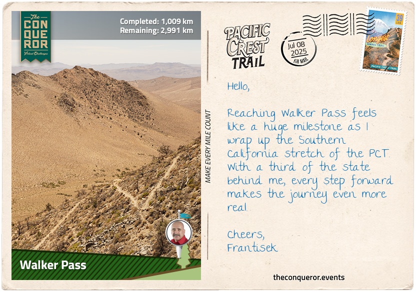
Walker Pass marks the end of this section of the trail. It's a National Historic Landmark, named for John Rutherford Walker, a 19th-century mountain man who relied on Native American knowledge to navigate and establish a route through these mountains. Nine years later, he led an immigrant wagon train through this very pass. As I take a break, letting the cool breeze dry the sweat on my back, I think about the countless footsteps that have passed through here before mine. And then, adjusting my pack, I add my own to the trail's long history.
km od začátku : 1180
Crabtree Meadows
The trail winds through the Sequoia National Forest, twisting around the side of Morris Peak. The incline isn't too bad, but I can feel the steady pull of elevation as I move higher. Mt. Jenkins looms to the east, and soon, I find myself passing through the western edge of the Owens Peak Wilderness. Owens Peak, the highest point in the southern Sierra Nevada, stands at the heart of it all. I pause briefly, taking in the rugged landscape stretching beyond me. It's hard not to feel small out here.
Owens Peak is named after Richard Owens, an explorer who accompanied John C. Fremont during his 1845 expedition. During the Mexican-American War (1846–1848), Owens served as a captain in Fremont's California Battalion. Fremont evidently held Owens in high regard as he went on to name a valley, a river, and a lake after him.
The trail takes on a rolling rhythm from Owens Peak, gaining and losing altitude like a slow breath. By the time I reach Sawtooth Peak, my legs are starting to feel the effort, but the changing scenery keeps me going. The path turns northwest, dropping toward Chimney Creek and into the Chimney Creek Campground, with Chimney Peak Wilderness rising to my left and Chimney Peak to my right. A lot of chimneys, indeed.
The terrain becomes drier as I approach the South Fork Kern River near Kennedy Meadows. The river, a tributary of the Kern, is the last major waterway on the western slope of the Sierra Nevada. Its banks once sheltered Native American tribes, but the gold rush of the 1850s brought settlers and conflict. It's a stark reminder of how landscapes hold the weight of history.
I take a slight detour from the trail to head into Kennedy Meadows, a small rural resupply outpost. At the general store, I pick up the resupply box I sent at the start of my hike—packed with nuts and trail mix, energy bars, dehydrated meals, and, of course, more coffee. But the most anticipated item? A new pair of already broken-in boots. After more than 600 miles (1,000 km) of hiking, I could feel the cushioning and support of my current pair wearing thin. It was time for a change.
Back on the trail, I cross the Kennedy Meadows Bridge, where the real challenge begins: an ascent of 3,300ft (1,000m) to Cottonwood Pass. The climb is relentless, alternating between wide meadows and dense conifer forests. I pause to catch my breath, the thin mountain air filling my lungs as I take in the sight of Deer Island—misleadingly named, as it's a peak, not an island, surrounded by plains and Cow Canyon.
Olancha Peak captures my imagination. From certain angles, the ridge resembles a human face—some see a man called 'Indianhead', while others see a woman lying on her back, known as 'the Sleeping Maiden'. I stare at it, trying to make out the forms before pushing on through the Golden Trout Wilderness. My legs burn as I cross Mulkey and Trail Pass, finally reaching Cottonwood Pass at 11,200 ft (3,413 m). The view is worth every step, with Chicken Spring Lake shimmering to the northwest, rocky meadows and foxtail pines to the south, and sheer granite cliffs rising to the north and east.
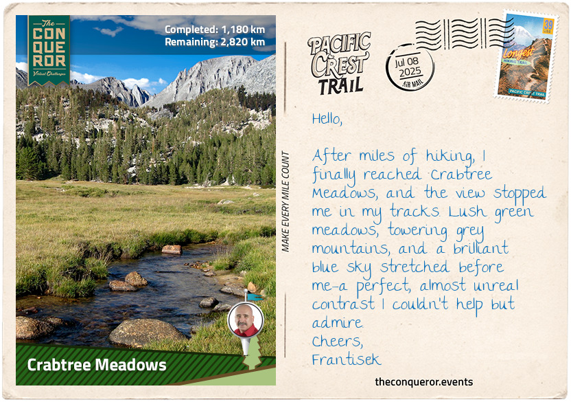
The last 14mi (23 km) to Crabtree Meadows feels almost leisurely, with the path undulating gently. A creek winds through the green expanse, pines standing tall around me. Just beyond, Mount Whitney's face rises into the sky.
km od začátku : 1453
Tuolumne Meadows
A short hike from Crabtree Meadows is the John Muir Trail. With its southern terminus at the summit of Mt Whitney, the trail descends its western slopes. Mt Whitney was named after Josiah Dwight Whitney, an American geologist whose extensive experience made him the foremost authority of his day in economic geology. On its summit is the Smithsonian Institution Shelter, a stone hut built in 1909 after a hiker was struck by lightning while having lunch. This shelter is a stark reminder of how wild and unpredictable this mountain can be, especially considering the tragic event that led to its construction.
The John Muir Trail merges with the PCT for a good stretch of 169mi (272km), and the beauty doesn't stop. There's no shortage of challenging terrain, either. The trail crosses at least eight passes that rise above 11,000 feet (3,352m), and I'm especially mindful of Forester Pass, the highest point on the PCT at 13,153ft (4,009m). The pass sits on the boundaries of Sequoia National Park and Kings Canyon National Park. The higher I climb, the more the landscape opens up—clear creeks, crystal lakes formed by glaciers, and alpine vistas stretching forever.
I've been hiking through Sequoia National Park, where no roads interrupt the wilderness. It's just me, my boots, and the trail. There's something humbling about this place, where bobcats and foxes roam freely, and the towering pines stand like silent sentinels. The biggest highlight here, of course, is General Sherman, a sequoia tree so vast it seems to touch the sky.
Continuing on, I enter Kings Canyon National Park, where the rugged beauty persists. The General Grant tree, named after President Ulysses S. Grant, stands just as impressively as its counterparts and, in 1926, was designated the "Nation’s Christmas Tree”.
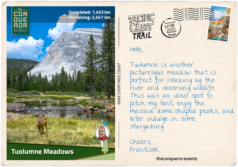
As I push forward, the Sierra National Forest and Yosemite National Park lie ahead. With its famous granite cliffs, waterfalls, and rich biodiversity, Yosemite is a place I’ve long dreamed of visiting. The trek finishes at Tuolumne Meadows in Yosemite, alongside the Tuolumne River and the junction of Tioga Pass Road, the highest paved through road in California's State Route System. Once a pack trail for prospectors during the Gold Rush, this road became a wagon road by the mid-1800s, extending all the way to Yosemite Valley. I find a sheltered spot in the meadows, pitch my tent, and finally catch my breath. Reflecting on the journey, I realise the high point of the trek is behind me—but the adventure is far from over.
km od začátku : 1556
Sonora Pass
Leaving Tuolumne Meadows, the trail quickly takes me to the meeting point of Cold Canyon, Conness Creek, and the Tuolumne River. Crossing a bridge over the river, I feel the rush of cool mountain air as I head north, swinging west and wading across Return Creek. The water flows around my boots, adding a refreshing coolness that helps ease my exertion as I continue my journey.
As the trail weaves past several peaks and waterways, I can't help but be drawn to the deeply winding Matterhorn Creek. Its serpentine path through the landscape is mesmerising, carving out its place in the wilderness. The moment I leave the creek behind, the trail becomes less forgiving, climbing steadily toward the barren expanse of Benson Pass. My legs burn with the effort, but the reward is in the beauty that unfolds as I approach Smedberg Lake and Volunteer Peak. Though Volunteer Peak isn’t high, famous, or particularly challenging to climb, it’s renowned for its stunning views.
Three miles (5km) further, I cross Piute Creek, which empties into Lake Benson a short distance away. With its broad, sandy beach, the lake stretches before me, its clear water mirroring the towering Piute Mountain above. I stopped for a bit to enjoy the stillness. The only sounds are the distant hum of nature—the whisper of the wind through the trees, the gentle lapping of water against the shore—a peaceful reward for the effort it took to get here.
Arriving at Wilma Lake, the trail joins Falls Creek, a long tributary of the Tuolumne River. For the next 8mi (13km), the creek is ever-present, sometimes drifting off before reappearing, guiding me through the landscape. The sound of the creek is soothing, and its rhythm helps carry me along.
As I pass Dorothy Lake Pass and follow the trail along Lake Harriet, vibrant wildflowers create a striking contrast against the rugged granite peaks. The trail arcs through Kennedy Canyon, eventually leading me into Stanislaus National Forest. The forest, established in 1897, is vast, with nearly 900,000 acres of pine, fir and old growth.
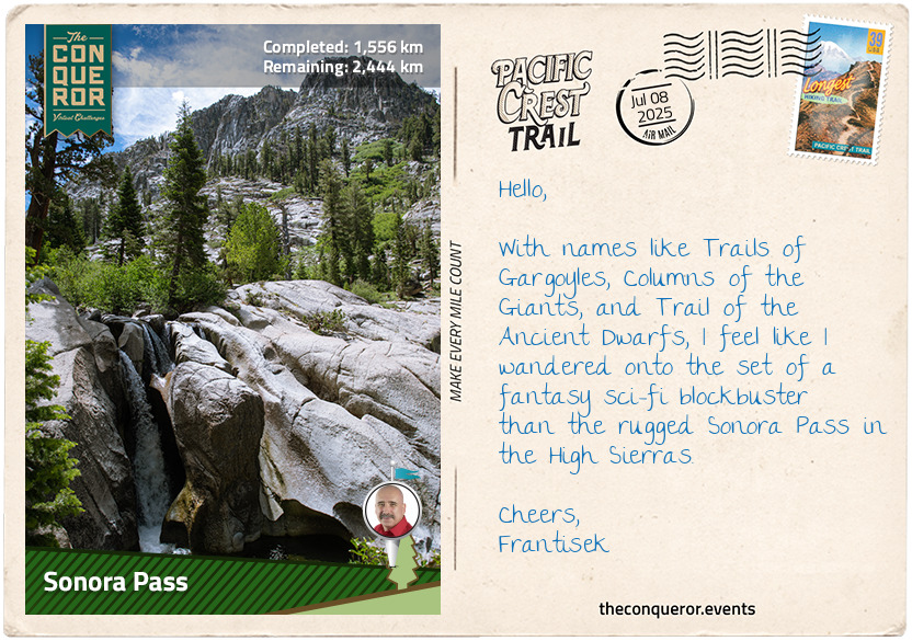
The final stretch takes me past Leavitt Peak and Leavitt Lake, each named for Hiram Leavitt, who once accommodated travellers crossing Sonora Pass. At 9,624ft (2,933m), it is the second-highest highway pass in the Sierra Nevada, linking the Sonora and Bridgeport communities. When gold and silver were discovered in the 1860s, both towns lobbied for a road to improve transport and trade, a goal realised in 1865. Yet its narrow, winding path remains a challenge even today, closing each winter under heavy snowfall.
km od začátku : 1667
Echo Lake
The trail northwest from Sonora Pass starts gently, tracing the East Fork Carson River through a valley before climbing into the high country. The first few miles eased me in, and the sound of rushing water was a steady companion. But soon, another ascent begins, and my legs feel the strain as the path winds through rocky terrain and sparse woodland. The air thins as I gain elevation, and I often pause to catch my breath, hydrate and replenish my energy with a protein bar while taking in the views.
I reach Ebbetts Pass, a place with a name tied to the Gold Rush era. John Ebbetts, a fur trader turned guide, led prospectors through this rugged terrain in 1851, believing it could be a viable route for a transcontinental railway. But later surveys deemed it too steep and treacherous. He planned to return for further exploration, but fate had other plans—three years later, he was killed in a steamer explosion. Standing at the pass, I try to picture him seeing a land full of promise yet relentless in its challenges.
As I round Raymond Peak, the trail rolls up and down, gaining and losing elevation as I approach Wet Meadows Reservoir. I’m struck by the number of lakes on this stretch, each with a delightful name—Lilypad, Summit, and Sunset—evoking peace and serenity. After pushing myself up the south side of Nipple Peak, I finally reach the ridge, where the blazing sun beats down without a hint of shade. The exposed trail feels never-ending, but just when I think I can't take it anymore, it dips near the West Fork Carson River, and a patch of chaparral woodland offers a much-needed moment of relief.
I finally reach Carson Pass, once a key point along the California Trail, travelled by thousands of emigrants during the Gold Rush. Later, it became part of the Eldorado Trail, linking the Sierra foothills to the bustling mining towns.
Nearby is the Devil’s Ladder, a landmark etched into the region’s history. The climb up from Red Lake, marked by Devil’s Ladder, was notorious for its brutality. Wagons had to be unloaded, and their contents were carried uphill by men while oxen teams winched the empty wagons up the steep slopes. The physical marks of this effort—rope scars on trees and wagon ruts carved into granite—are still visible in the landscape.
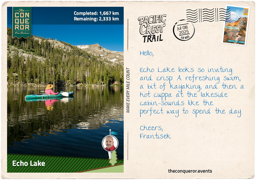
From Carson Pass, I ventured through the expansive Dixon Valley, skirted the serene shores of Showers Lake, and slowly descended into Echo Lake, a quaint community nestled near the glacial waters in the heart of Eldorado National Forest. The forest itself is a stunning landscape, stretching from the foothills at 1,000ft (300m) to the towering peaks of the Sierra crest, reaching over 10,000ft (3,000m). It’s a mix of dramatic canyons and vast plateaus, with the land covered in chaparral, oak woodlands, and dense forests of pine, fir, and ancient old-growth trees.
km od začátku : 1762
Donner Summit
The trail wound through the rugged terrain, and soon, I was surrounded by a series of pristine lakes, each offering its unique beauty. Among them was Ralston Lake, situated beneath Ralston Peak, named after William Chapman Ralston, a key figure in California’s history. He founded the Bank of California in 1864, the first commercial bank in the western U.S. and once the second wealthiest in the nation.
Ralston’s influence extended beyond banking, building the luxurious Palace Hotel in San Francisco. The hotel was one of the most lavish and technologically advanced of its time, boasting modern amenities like indoor plumbing, electric lighting, and a sophisticated heating system. It quickly became a symbol of the wealth and grandeur that defined California’s growing status. Unfortunately, Ralston’s financial empire collapsed only days before the hotel’s opening. While the bank collapsed, the hotel endured, remaining an iconic part of San Francisco’s landscape.
Crossing Dick's Pass and descending to Dick's Lake at the base of Dick's Peak, I was sure there was a story behind the name. It turns out that all these places are tied to the legend of Captain Richard "Dick" Barter, the "Hermit of Emerald Bay".
This eccentric 19th-century Englishman lived in complete solitude in Emerald Bay off Lake Tahoe for at least a decade, working as a caretaker. Known for his oddities, he built himself a rock grave on the bay’s only island and crafted a 7ft (2m) model of a steam frigate. With time on his hands, Dick also built a full-sized boat named Nancy. Partial to bourbon, he regularly rowed 16mi (25km) to Tahoe City for a few social drinks. One night, 6mi (10km) into his return journey, his boat capsized. Tying a bowline around his chest, he swam back to shore, tucked himself into bed, and went to sleep. The next day, he woke to frostbite on his toes, which he then amputated himself. Good ol’ Dick thought nothing of it, regaling his drinking buddies with stories of the ordeal. He wasn’t so lucky the next time, though, when his boat was found smashed to pieces. Having never found his body, Dick was presumed dead.
Pushing onward, I got a fabulous view of Lake Tahoe. Somewhere in the deep blue below, Tahoe Tessie was probably watching, but she stayed out of sight—perhaps not a fan of hikers. A distant cousin of Scotland’s Nessie, Tessie is said to lurk in the lake’s depths, surfacing just often enough to keep the legend alive. Maybe she enjoys the solitude, much like the old hermit Captain Dick, or perhaps she’s just waiting for the right moment to prove she’s more than a ripple in the water.
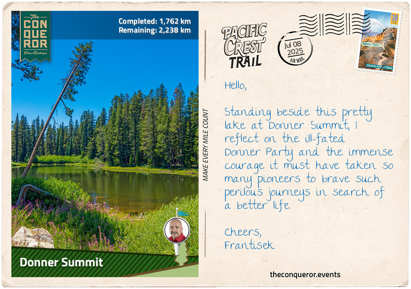
Reaching Donner Summit was a cause for celebration. Two-thirds of the PCT in California was now behind me. With the Central California stretch complete, I could reflect on how far I’d come. The miles had tested me, but standing there, I was proud of my accomplishment.
Yet, this place holds a much darker history. In the winter of 1846-47, the Donner Party became trapped by heavy snowfall, their hopes dashed by the harsh conditions that led to starvation and tragedy. As I stood there, with the wind howling through the pines, it was impossible not to think of their isolation and desperation. For me, the trail stretched on, but for them, this was the end of the road.
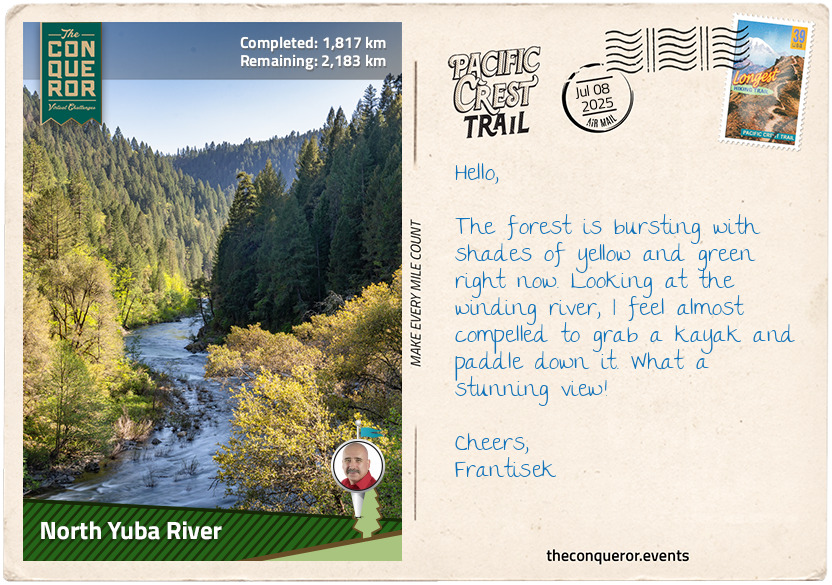
km od začátku : 1817
North Yuba River
The trail beneath I-80 is quiet, save for the occasional rustling of leaves as I make my way through the underpass, moving from the bustle of the highway into the peaceful woodland. The trail turns left, guiding me past lakes and through thick forest. As I crest the rise and descend, the landscape unfolds, revealing a valley between Basin and Castle Peaks. The two mountains form a striking natural bridge, their ridgelines connecting in a dramatic, seamless arc. From up here, I can see the PCT winding below beside Frog Lake and Prosser Reservoir.
As I navigate switchbacks through the dense forest, each turn demands more of my energy. The burn in my legs is relentless, my calves and shins protesting with every step as the steep incline forces them to work harder. Each movement sends a wave of discomfort, a constant ache that builds with every upward stride. Yet, despite the pain, I press on, feeling the weight of the trail pushing me deeper into this wild landscape, where the forest grows thicker, more untamed with every upward stride.
At North Creek, I’m fortunate to cross a solid bridge before continuing my ascent, the mountain slope rising steadily beneath my feet. But my luck runs out at White Cross Creek. The bridge is nowhere in sight, and I’m faced with fording the shallow, cool waters. Reluctantly, I sit on a nearby rock, pulling off my boots to save them from getting soaked again. The cold water chills my toes, but it’s the least of my worries as I carefully test each step, searching for stable rocks beneath the surface. My heart races a little as I manoeuvre, balancing myself and watching the current swirl around my legs. Each step feels like a small gamble, the slippery stones threatening to send me tumbling, but I steady myself and make it across. With my boots back on and my legs a little wobbly, I’m ready to continue the climb.
As the trail winds through Bear Valley and skims the Jackson Meadows Reservoir, I pause to take it all in. The history of this place isn't immediately apparent, but knowing that this reservoir was created by the damming of the Middle Yuba River gives it a deeper sense of life and purpose. The dam was part of the ambitious Yuba-Bear Hydroelectric Project, a critical piece of infrastructure that helped support the growing needs of the surrounding communities. The project, which involved the construction of several dams and power plants along the Yuba and Bear River systems, was designed to control flooding, provide irrigation water and generate hydroelectric power for the region. It’s one of many engineering feats that shaped the area, transforming it from a rugged wilderness into a resource-rich backbone of the local economy. The Jackson Meadows Reservoir itself became an important part of this network, storing water for both agricultural use and electricity generation.
The trail continues, guiding me through a dense ravine, the trees thickening as I descend towards the North Yuba River. Sierra City, just a short distance away, feels like a time capsule. In 1850, Philo A. Haven and Joseph Zumwalt were among the first to settle here. Three years later, disaster struck when an avalanche buried the town, sweeping away what little had been built. But the settlers, like many others during the Gold Rush, were determined to rebuild, driven by the promise of gold. The effort paid off when a 106lb (48kg) gold nugget was discovered, sparking a renewed rush of prospectors.
Entering Tahoe National Forest, the trail winds through this vast expanse, hugging the western edge of Lake Tahoe. The contrast between the lush, forested lower elevations and the jagged, high-elevation terrain of the Granite Chief Wilderness is striking. The rugged wilderness, with its towering granite outcrops, provides a vital nesting ground for birds of prey, including golden eagles and peregrine falcons.
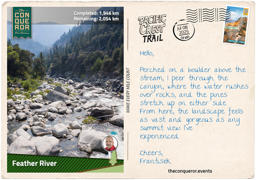
km od začátku : 1946
Feather River
After crossing North Yuba River, the trail begins to climb sharply, gaining 1,400ft (426m) through tight switchbacks. As with any climb, it’s another strenuous ascent, but before long, I am on the flanks of the Sierra Buttes Peaks, some 2,000ft (610m) above Sierra City. The town, with its small population, is now just a distant speck.
I truly enjoy walking along ridgelines. There’s something about how the views open up, offering a sense of freedom. From here, the landscape stretches out in every direction. Below me, I can see a series of lakes nestled amidst the peaks of Mount Elwell and Mount Washington. I pause, taking it all in.
At McRae Ridge, I exit Tahoe National Forest and enter the historic Plumas National Forest. Sprawled over a million acres, this forest has more than 127,000 old-growth trees. As I take in the views, I reflect on how the landscape has been shaped by centuries of logging. It started during the gold rush when timber was vital for mining, fuel, and construction. This expansion continued into the 20th century, leading to the felling of much of the original old-growth to meet growing demand. The loss of these ancient trees and their deep root systems that stabilised the soil profoundly impacted the ecosystem. While younger trees have since emerged, they can’t replace the complexity and biodiversity of the original forest. Debates over protecting the remaining old growth while balancing economic needs continue to evolve.
Moving on, the trail winds through woodland and descends alongside Onion Valley Creek. Here, I cross the Middle Fork Feather River via a bridge. This major river, at nearly 100mi (160km) long, has been designated a National Wild and Scenic River, protecting it from future developments, such as dams. Though rarely visited due to its remoteness and challenging terrain, the designation guarantees the preservation of its natural landscape.
From Mount Pleasant, I begin a long, gradual descent to Feather River near Belden. As a major tributary of the Sacramento River, it was at the heart of gold mining in the 19th century. It continues to serve as a crucial water source, supporting hydroelectric generation. This is the perfect spot to fill up my water bottles, and I take care to filter them. Water filtration is essential here, as it removes harmful bacteria, viruses, and contaminants that can lead to illness. It’s a necessary step to ensure the water is clean and safe to drink, especially in remote areas like this where access to reliable water sources is limited.
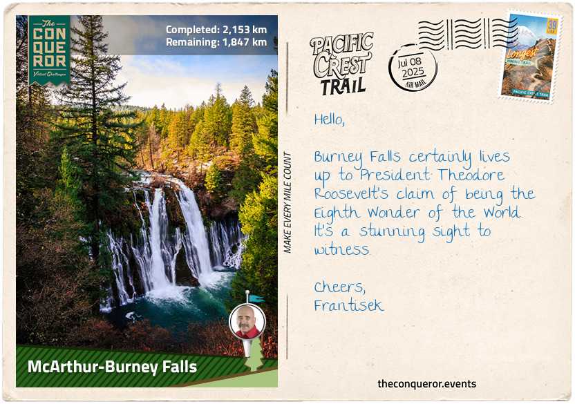
km od začátku : 2153
McArthur-Burney Falls
Trailing along the mountain slope alongside Chips Creek, I’ve entered Lassen National Forest, named after pioneer Peter Lassen. Born in Denmark, Lassen emigrated to the United States in the early 1800s, looking for a fresh start in the expanding frontier. At the time, California was a melting pot of cultures—Native Americans inhabited the land, Russians held territory on the coast, Mexicans were in control, and British and North American settlers vied for a stake in the land. In this diverse, often conflicting environment, Lassen’s Danish background made him stand out, yet it didn’t stop him. He became a guide and prospector, playing a key role in opening up northern California through his work on the Lassen Trail, an offshoot of the California Trail. His resilience and ability to forge through challenges made him a true frontiersman.
The forest wraps around Lassen Volcanic National Park, with Lassen Peak as its highest point. Although not directly on the trail, it's worth noting that Lassen Peak marks the end of the Sierras and the start of the Cascade Range.
As I reach Humboldt Peak, the trail curves, skirting the ridge near Butt Mountain. The air cools, offering a refreshing change, and the sound of rushing water fills the air. The trail dips into the valley, running beside the North Fork Feather River. After crossing the creek, I ascend the opposite slope. The climb grows steeper, and each step takes more effort. I pause now and then to peek at the views through the trees.
The forest remains thick until I arrive at Little Willow Lake, a rare and special botanical spot. The shore is covered in sphagnum moss, transforming the area into a fen, a wet meadow without soil. This unique habitat supports plants like American Scheuchzeria, which was once thought extinct until its rediscovery here in 1988. Carnivorous plants like English sundew and roundleaf sundew feast on flies, while blooming herbs add colour to the fen. Because of its rarity, Willow Lake has been designated a Botanical Special Interest Area.
After soaking in the beauty of Willow Lake, I return to the PCT and soon encounter the Terminal Geyser, spewing water from deep beneath the earth's surface. Just ahead, Boiling Springs Lake catches my eye with its milky surface, resulting from an underground heat source that produces hydrochloric acid and sulphurous fumes. As I approach the shore, the air is thick with the scent of minerals, where boiling mud pots bubble and hiss, adding to the eerie and fascinating geothermal landscape.
The trail then takes me through Warner Valley, winding past lakes and peaks and circling Badger Mountain. It climbs steeply with long switchbacks, offering a challenging yet rewarding ascent. At the top, I follow the slope before descending into Plum Valley, then rise again, contouring around a canyon before dropping down near the Cinder Flats State Wildlife Area, a peaceful haven for birdwatching. Reaching Baum Lake marks the end of this section, with the journey culminating at Burney Falls in McArthur-Burney Falls State Park, California's second oldest state park. Named after pioneer Samuel Burney, the falls were preserved in the 1920s by the McArthur family and, in 1954, was designated a National Natural Landmark.
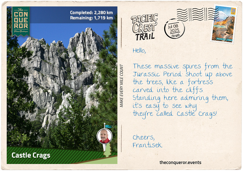
km od začátku : 2280
Castle Crags
Having entered the Cascade Range, before I take off on my hike, let me give you an insight into this extensive mountain range. Running from north-south, the range is 700mi (1,100km) long and 80mi (130km) wide. It starts in British Columbia, Canada, extending through Washington, Oregon and Northern California. With its highest peak in Washington State, the range is also home to several volcanic mountains. The Cascades are part of the Pacific Ocean's "Ring of Fire", a zone of volcanoes and earthquakes circling the Pacific. The last two eruptions in the contiguous U.S. were in the early 20th century when Lassen Peak had its largest eruption in 1915 and Mount St Helens in 1980.
Crossing the dam at Lake Britton, I follow the trail that winds over DeLucci Ridge. The climb is gradual, ascending to 5,400ft (1,645m). The mix of forest and large open meadows makes the journey feel ever-changing. I catch my breath near Mushroom Rock as I approach Grizzly Peak. The valleys stretch out below, a patchwork of green and rugged terrain.
From Grizzly Peak, I descend into a valley to follow Deer Creek for about 5mi (8km), passing through Doodlebug Gulch before crossing a bridge over McCloud River. The river, named after hunter and trapper Alexander Roderick McLeod, had its spelling changed over time, partly to honour early pioneer Ross McCloud, who helped improve the region’s roads and railways in the mid-1800s.
The trail winds up and down through the dense woodland of Shasta-Trinity National Forest. As I reach the slopes of Girard Ridge, I climb to its historic lookout for the spectacular views of the Sacramento River Canyon, Mount Shasta and Castle Crags.
After another 10mi (16 km), the trail descended to 2,200ft (670m), crossing the Sacramento River and entering Castle Crags State Park. As the principal river of Northern California, the Sacramento originates in the Klamath Mountains and flows south for 400mi (640km) into San Francisco Bay. When gold was discovered, prospectors flooded its waters in search of fortune, forever altering the landscape.
Within the park, the grey spires of Castle Crags rise dramatically, rock formations dating back to the Jurassic Period. This land was once sacred to Native Americans, who relied on the Sacramento River for its abundant fish and the surrounding wilderness for game. But the Gold Rush brought disruption. Miners muddied the river, depleted wildlife, and in 1855, growing tensions led to violent conflict. Thanks to conservation efforts, the land was protected in 1933, and today, it thrives as a refuge for nature, home to 300 species of wildflowers, including the rare Castle Crags Bellflower.
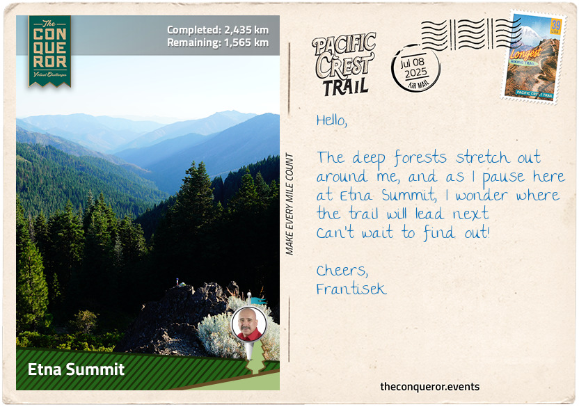
km od začátku : 2435
Etna Summit
As I climbed higher into Castle Crags State Park, I thought about the early explorers who crossed these rugged mountains, their stories etched into the rocks around me. One of the most influential was John C. Fremont, whose detailed maps of California and the Oregon Trail played a crucial role in the westward expansion. His explorations opened the way for settlers to reach the Shasta Valley, just beyond Castle Crags, and laid the groundwork for the Transcontinental Railroad.
But long before Fremont's expeditions, this land was home to the Yurok and Karuk people. These tribes knew the land intimately, relying on its rivers, lakes, and forests for sustenance and spiritual practices.
Continuing north, I passed between two lakes, contemplating the difficulty of the terrain. It’s a wonder at the courage of those who attempted to traverse it. Many didn’t make it, but one of them who did was Father Florian Schwenninger. An Austrian from Innsbruck, Father Florian migrated to the U.S. in 1844. A few years later, he entered the wilds of Klamath National Forest and built the Sawyers Bar Catholic Church in 1855. The church, still standing today, was a beacon for those who ventured into these remote mountains in the mid-1800s, seeking fortune and solace. Father Schwenninger’s first Mass, held in 1857, marked the beginning of a spiritual journey and devoted service.
Climbing toward Russian Peak, I entered the Russian Wilderness, established as part of a larger effort to protect untouched landscapes from logging and development. This 12,000-acre area safeguards Russian Mountain and connects to the Trinity Alps Wilderness and Marble Mountain Wilderness, forming a vital corridor for migrating wildlife. Early conservationists like Bob Marshall and Aldo Leopold were instrumental in advocating for wilderness areas like this, stressing the importance of preserving such places for future generations.
Bob Marshall, a wilderness advocate, and Aldo Leopold, a renowned ecologist, were central to founding the Wilderness Society and pushing to protect wild landscapes. Thanks to their efforts, the organisation helped create the 1964 Wilderness Act, which led to the creation of the National Wilderness Preservation System, now protecting 109 million acres of U.S. public wildlands.
By the time I reached Etna Summit, I couldn’t ignore the delicate balance between human progress and wilderness preservation. We push forward, expanding and building, yet these wild places remind me that not all growth should come at nature’s expense. The real challenge is finding a way to move ahead without losing sight of what makes these landscapes so invaluable—where development and conservation aren’t at odds but in harmony.
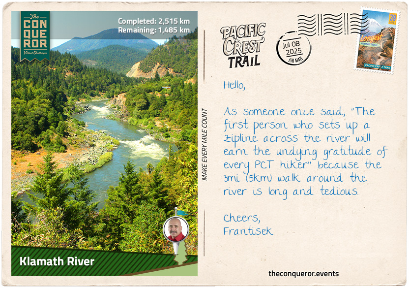
km od začátku : 2515
Klamath River
The next 15mi (24km) were relatively quiet as I followed the trail along the ridgeline. Then, I reached a crest with views of Cliff Lake in the large valley below and Campbell Lake peeking out beyond it. As I continued another 5mi (8km), I came across Sky High Valley, where three lakes sat close together. Looking north from here, the striking white cliffs of Marble Mountain rose above the treeline, standing out against the green.
When the PCT met the Marble Mountain Trail, I veered right and began the descent into Little Marble Valley. The terrain shifted, with white rocky slopes stretching above the mountain cliffs. Marble Mountain, part of the Marble Mountain Wilderness, was just ahead. This wilderness spans 225,114 acres and is home to 89 lakes, surrounded by oak, fir, pines, and hemlock.
As I hiked, I marvelled at Marble Mountain’s bright white cliffs, their glacially polished granite standing out against the landscape. Its peak’s curved escarpment caught my attention. The escarpment is split into two segments, with Marble Gap near the centre, giving it a distinctive shape. The mountain’s gradual eastern slope, where the PCT runs through, offered sweeping views of Marble Valley, while the western side was dominated by sheer cliffs with streams rushing at their base.
Flowing for 257mi (414km), the Klamath River stretches across Oregon and Northern California before reaching the Pacific Ocean. It’s the second-largest river in California by discharge, its waters winding through the Cascades and Klamath Mountains. The river, once a vital food source for Native Americans through its salmon and steelhead runs, has dramatically changed since European settlers arrived in the 1820s. Over the years, mining, the gold rush, and the construction of dams transformed its ecosystem.
As I neared Seiad Valley, a small town of just 350 people, I realised I was only 15mi (24km) from the Oregon border. Ready for a break, I stopped at the historic Wildwood Tavern and Lodge. Nearly 100 years old, the tavern is best known for its 24ft (7.3m) long bar, which has been preserved through various remodels and ownership changes. There is no better place to unwind as it still welcomes passing travellers like me.
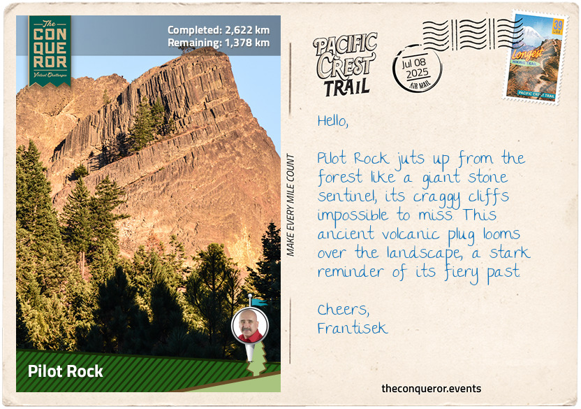
km od začátku : 2622
Pilot Rock
The climb out of Seiad Valley was challenging, to say the least, with a 3mi (5km) steep ascent of 2,000ft (610m). It continues climbing, although a little gentler, towards Kangaroo Mountain before descending its southern flank and traversing along the foot of the mountain.
I passed by Lily Pad Lake and headed towards White Mountain Peak, which, at 14,252 feet (4,344 m), is the third-highest peak in California. It's one of the only two peaks in the state over 14,000ft (4,267m) outside the Sierra Nevada. The University of California even runs research stations here at various altitudes to study how the body reacts to higher elevations.
A few miles later, I skirted around the south side of Condrey Mountain, then crossed into Oregon. This was such an exciting milestone. I stopped at the border and did a little dance, celebrating this momentous occasion because it marked my completion of the California portion of the PCT and two-thirds of my journey. Oregon’s flatter terrain and shorter distance should be a breeze to get through.
The landscape shifted as I trekked through the woodland toward Observation Gap, where it suddenly opened up to a dry, barren terrain fully exposed to the elements. The change was stark, and I could feel the sun's intensity on my skin, the wind picking up as I ventured into the open. The weight of being so exposed made me feel small like the landscape was swallowing me whole. There was nowhere to hide from the elements. I took a moment to hydrate, have a protein snack, and carry on through several gaps before taking a quick jaunt off the trail up to Siskiyou Peak. The view from the top was becoming familiar—an expansive, verdant landscape stretching out with lakes and mountain after mountain, a reminder of the vastness of this place.
Just 3mi (5 km) away stood Mount Ashland, the highest peak in the Siskiyou Mountains. In winter, it transforms into a ski resort blanketed in snow, with skiers and snowboarders carving down its slopes. But in summer, the landscape bursts into colour with a superbloom of wildflowers. Lupines, Indian paintbrush, and mountain buttercups spread across the meadows, turning the slopes into a vibrant patchwork of purples, reds, and yellows.
Continuing, the trail wound through the forest to the base of Pilot Rock, a 25.6-million-year-old volcanic plug that juts 570ft (170m) above the tree line. You can spot this massive rock as far as 40mi (64km) away. As one of the oldest formations in the Cascades, it stands protected in the Cascade-Siskiyou National Monument. The rock formed when magma broke through the earth's crust, solidified beneath the surface, and then cooled, creating striking layers. Over time, the Siskiyou Mountains' gradual uplift tilted the rock about 20 degrees due east, giving Pilot Rock its distinctive appearance.
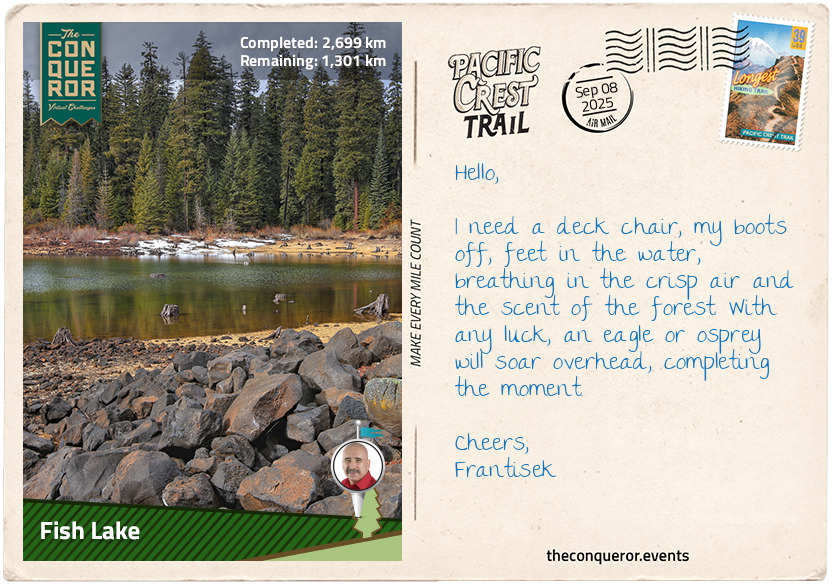
km od začátku : 2699
Fish Lake
Hiking through the Cascade-Siskiyou National Monument, I was very aware of how diverse this place is. Established in 2000 and further expanded in 2017, it protects over 114,000 acres at the meeting point of the Cascade Range and the Siskiyou Mountains. Unlike most national monuments often designated for historical or geological significance, this one was set aside specifically to preserve biodiversity. With over 200 bird species, including the threatened Northern Spotted Owl, and waterways critical to salmon in the Klamath River, it’s a haven for wildlife. Some plants exist nowhere else, like Green’s Mariposa Lily and the critically endangered Gentner’s Fritillary. More common but still useful, the Blue Elderberry shrub grows along the trail. Its flowers can be brewed into tea, and its berries are edible.
Passing a couple of reservoirs, I reached the catchment of Hyatt Reservoir. Created in 1923, it’s stocked annually with 250,000 young rainbow trout, drawing anglers from far and wide. Usually bustling with campers and boaters, today, it was quiet. I took the time to swim and cool off. A few miles later, I arrived at the even larger Howard Prairie Lake. Surrounded by fir and pine, the still water and towering trees made for a peaceful stretch of trail as I pressed on.
After another 15mi (24km) of trekking through dense forest, I reached the south side of Brown Mountain. The PCT skirted around its western foot, cutting across a vast field of solidified lava. The dark volcanic rock, with only a few sparse trees scattered across it, was a stark contrast to the thick greenery I’d been hiking through. Brown Mountain, a cinder cone at 7,344ft (2,238m), looks relatively young, but its origins date between 12,000 and 60,000 years. Its last eruption, about 2,000 years ago, left behind lava flows over 250ft (75m) deep. While the base is cloaked in old-growth forests, the summit is mostly bare, opening up views of Mount McLoughlin to the north and Fish Lake to the northwest.
Fish Lake was originally a small natural lake until a dam was built in 1898 to supply water to Rogue Valley. In the early 1900s, engineers connected it to Fourmile Lake for extra water storage. Today, it’s a peaceful recreation spot popular for trout fishing, boating, and swimming. After miles of rugged terrain, the sight of calm water was a welcome change, and I decided it was a good place to pitch my tent for the night.
km od začátku : 2821
Mount Thielsen
Crossing Highway 140, I find myself between Brown Mountain and Mt McLoughlin, with Fish Lake shimmering to the west. The trail climbs steadily, wrapping around the east flank of McLoughlin, a steep-sided, dormant volcanic giant. The mountain was named after John McLoughlin, a trader with the Hudson Bay Company who played a key role in the history of the Oregon Trail. As the Chief Factor of the Hudson’s Bay Company at Fort Vancouver, he provided food, medical aid, and supplies to pioneers arriving in the Oregon Country. His generosity earned him the nickname “Father of Oregon”. Later, he set up a general store in Oregon, which became a major stop for settlers at the end of their long journey west.
Further along, I reach Fourmile Lake; its vast 483-acre expanse is significantly larger than the neighbouring Fish Lake. A canal connects the two, allowing excess water to flow into Fish Lake for storage. The surrounding Fremont-Winema National Forest was formed by merging two forests. Fremont National Forest was established in 1908, and nearly half is still covered in old-growth trees. It’s also home to ancient lava flows and fault-block mountains. Two former uranium mines within the forest have been cleaned up and restored. Winema National Forest has a different story. Once a Klamath Native American Reservation, it now includes vast wetlands that provide a crucial stop for migratory birds along the Pacific Flyway.
The trail leads into the Sky Lakes Wilderness. This pristine sanctuary with over 200 pools of water has some of the purest lakes in the world. As I hike through Sky Lakes Basin, Marguerette and Trapper Lakes glisten in the sunlight, their surfaces rippling with the breeze. Further along, the trail winds towards the Seven Lakes Basin, where I catch glimpses of the strikingly narrow Alta Lake, so long and slender it could be mistaken for a river. Nearby, the still waters of Cliff Lake rest in the shadow of two towering peaks, their jagged, craggy silhouettes reflected perfectly on the calm surface.
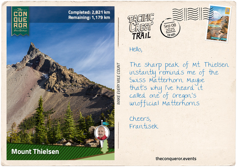
The path continues past Red Cone Peak and Grouse Hill before skirting the edge of the Pumice Desert, a stark, open landscape shaped by ancient volcanic eruptions. The journey eventually leads to Mount Thielsen, an extinct volcano rising sharply against the sky. Its jagged, horn-like peak results from centuries of glacial erosion, transforming it into a challenging black-diamond ski run in winter. Explorer Jon Hurlburt named the peak after Hans Thielsen, a railroad engineer involved in constructing the California-Oregon Railroad. I wonder if Hurlburt saw something in this peak, its sharp, deliberate rise mirroring the precision and ambition of laying tracks through untamed wilderness.
km od začátku : 2887
Diamond Peak
I set off from the western flank of Mount Thielsen, the trail leading me north through the Mount Thielsen Wilderness. I passed over Windigo Pass, the path descending and rising again as I reached a ridge that allowed me to pause and enjoy the view of Windigo Lakes below.
A few miles later, I hiked around the west side of Cowhorn Mountain. The upper portion of the mountain was fully exposed to the sun, and the hike to the summit proved challenging. The scree was loose beneath my feet, making each step feel uncertain. I had to scramble over rocks, carefully finding my footing as I climbed higher. The effort was exhausting. My heart was pounding, my quads burning, and my muscles twitching from the strain. I sat to recover, letting the fatigue settle while taking a long swig of my electrolyte water. As I caught my breath, I snapped a few photos of Crescent Lake below, its crescent shape curving gracefully around a sandy shoreline, a gorgeous contrast against the deep green of the surrounding forest.
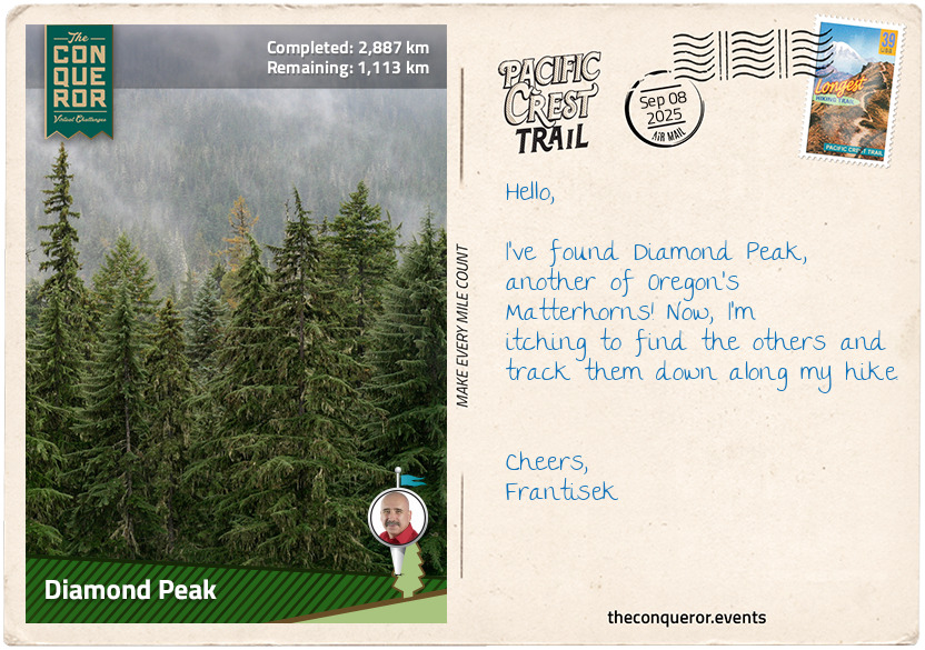
I continued along the ridge, the trail weaving through the woods as I descended. The path skirted the west end of Summit Lake for about 1.5mi (2.4km), passing tarns scattered across the landscape before I arrived at the base of Diamond Peak. As I climbed higher, the air grew thinner, and the landscape became more dramatic, the slopes of Diamond Peak rising steeply before me.
Diamond Peak, a 100,000-year-old volcano, loomed in front of me. I marvelled at the steep, craggy slopes and the sharp ridges cutting across the mountainside. Glaciers had carved deep cirques into the rock, leaving behind dramatic amphitheatre-like valleys. Making my way up the eastern flank of the peak, I looked up at its full height, feeling somewhat small standing there. The wilderness around me was alive with conifers, flowers, and wildlife, including the occasional raven soaring overhead.
The mountain sits within the Deschutes and Willamette National Forests, both established in the early 20th century. Willamette National Forest was created by merging two forests, with one-fifth of its land designated wilderness. It became a focal point in the battle between loggers and environmentalists working to protect the endangered northern spotted owl, which led to logging restrictions in its habitat. Deschutes National Forest, formed from parts of three forests, is known for its old-growth areas and over 250 documented caves, ranging from lava tubes to ice caves, some of which provide a unique habitat for bats and other wildlife.
km od začátku : 3016
McKenzie Pass
As I skirted the eastern slope of Diamond Peak, the trail began to descend, leading me past the serene Odell Lake near Willamette Pass. The lake, a natural basin carved by a glacier, is home to trout, salmon, and whitefish. A 40lb (18kg) trout was one of the most famous catches. Though not visible from the PCT, the nearby Waldo Lake is known for its incredibly clear water, which can be seen to a depth of 120ft (36m) on a clear day. The lake is named after Judge John B. Waldo, a surveyor general from Oregon who helped preserve the Cascades, eventually leading to the creation of a national forest.
I entered the Three Sisters Wilderness, eager to hike along the west side of the Three Sisters, comprising the towering volcanic peaks of the South, Middle, and North Sisters. The path wound through rocky terrain, offering stunning views of these giants, each more imposing than the last. As I reached the far end of North Sister, I encountered Opie Dilldock Pass, where the trail steepened sharply, demanding a short but challenging climb. My muscles burned with effort as I crested the rise, but the payoff was immediate as I descended slightly and reached Yapoah Crater. With its smooth, polished basalt surface, this small, barren cinder cone looked almost otherworldly. I couldn't resist the urge to scramble up to the top to peer inside the crater.
Back on the trail, I finished this section at McKenzie Pass, crossing a vast expanse of solidified lava. Nearby, the Dee Wright Observatory stood—an open, lava-stone structure built into the flow. The observatory’s windows were designed to offer views of the surrounding Cascade peaks. I took a moment to marvel at the landscape before continuing.