It's been a great first day. When I arrived in Iceland at Keflavik International Airport, instead of going straight to Reykjavik, it was recommended that I take a side trip to the geothermal spa named Blue Lagoon. It is located in a lava field and the water is supplied by the nearby geothermal power plant. This man-made lagoon has a milky blue colour which is largely due to the high content of silica (a chemical compound containing oxygen and silicon). The lagoon is also high in algae and salt. Bathers with psoriasis have found it beneficial to their skin to bathe in the lagoon.
Having spent a couple of hours in the lagoon, a great way to rejuvenate from my flight, I headed into Reykjavik for some exploration. Reykjavik is the capital city of Iceland and the world's most northernmost capital. The first settlement was in 874AD and the city itself was founded in 1785 as a trading town which steadily grew and expanded to become the national centre it is today.
I headed to Grandi Harbor as several points of interest are located there and started with a visit at the Whales of Iceland, a wonderful museum exhibiting 23 man-made life size models of various whales. I was particularly taken by the 25m (82ft) long blue whale model. It's a tactile experience as each hand-painted model is designed to be soft and squishy and accessible to visitors.
Nearby is the Maritime Museum exhibiting Iceland's maritime history including displays of 100-year old fishing boats. What makes this visit interesting is the decommissioned Coast Guard and rescue vessel Óðinn moored near the museum providing visitors an opportunity to see and learn about its custom design and special duties patrolling Iceland's territorial fishing grounds. During its service (1960-2006) the vessel towed 200 ships to safety, rescued stranded crews and twice saved the lives of crews from sinking ships.
At the north-east edge of Grandi is a small dome shaped hill with an encircling path to the top. This art installation with a fish drying shed on top is a lovely contemplative spot with a terrific view of the harbour and the glistening honeycomb design of the Harpa Concert Hall.
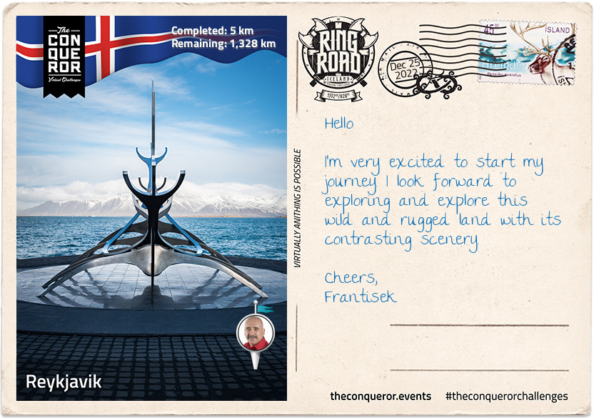
As I made my way along the shore, I came across the Sun Voyager, a stainless steel sculpture designed by Jón Gunnar as a commemoration of the city's 200th anniversary. Often mistaken as a Viking ship, the artist describes the work as "...a dream boat, an ode to the sun. It symbolizes the promise of undiscovered territory, a dream of hope, progress and freedom."
With that in mind, I forge ahead and commence my 1,332km (828mi) round-the-island journey on Route 1 better known as Ring Road.
Take care and I'll write again soon.
See ya,
Frantisek
km od začátku : 0078
Borgarnes
The Ring Road can be enjoyed in any direction, so I decided to go north and arrived in Borgarnes. It was fun travelling beneath Hvalfjörður fjord through the Hvalfjörður tunnel to get here. This 5.8km (3.8mi) long tunnel connects Reykjavik to the western and northern parts of Iceland. Apparently it reduces the travel by 45km (28mi). I also crossed Iceland's second longest bridge at 521m (1700ft) known as Borgarfjarðarbrú just before entering town.
Borgarnes is the gateway to Snaefellsnes Peninsula and the National Park within it holds Snaefellsjökull, a cone-shaped 700,000 year old glacier-capped stratovolcano that is often referred to as the “crown jewel of the peninsula" and it's the famous setting for Jules Vernes' novel Journey to the Centre of the Earth.
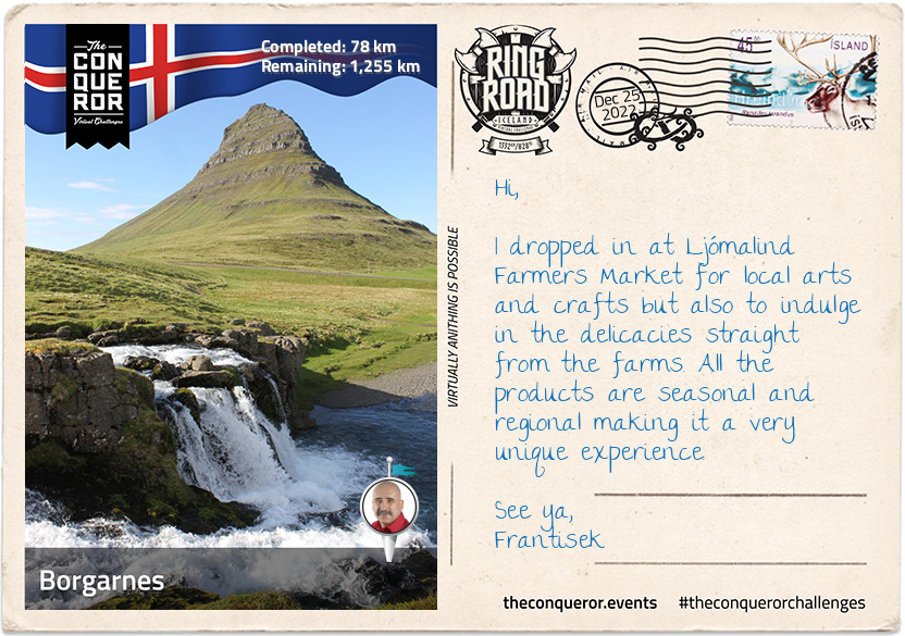
North of the Peninsula is the most photographed Kirkjufell Mountain. At 463m (1519ft) high the mountain beckons hikers to its summit for a breathtaking view but it's only suitable to hikers who don't suffer vertigo and are fit enough to take on the treacherous climb near the top. For movie buffs, Kirkjufell features in Games of Thrones (Season 6 & 7).
Nearby Borgarnes are several waterfalls, each with their own characteristics, such as Glymur, Glanni, Hraunfossar and Barnafossar Waterfalls. Glymur, accessed via a rugged trail, is the second tallest in Iceland with a cascade of 198m (649ft) falling into a canyon. Glanni sits near an ancient lava field but it is also said to be the home of elves and trolls. Hraunfossar and Barnafassor are near each other and both stream out of Hallmundarhraun, a lava plain created by volcanic eruptions on Langjökull, the second largest ice cap in Iceland.
There are four national forests within the region with a mix of birch woods and native conifers, however, some of the tallest and oldest birch trees can be found in Borgarnes. Anyone familiar with Iceland, will probably know that it is quite a treeless landscape largely a result of deforestation during Viking settlement, sheep contributing to soil erosion which couldn't support trees and lastly volcanic eruptions covering areas that previously were fertile areas. Fortunately reforestation projects have been underway for the better part of the century including incentives offered to farmers who can obtain a grant if they create a section of woodland on their land.
Bye for now,
Frantisek
km od začátku : 0193
Laugarbakki
Laugarbakki may be small but they were forward thinking when they converted an old school into a hotel with modern Nordic designs. With all necessary amenities on the premises, I settled in for a few days and explored the surrounding area.
My first stop was the nearby Folk Museum which houses Ófeigur, the 19th century ship that refined oil from the sharks it caught and sent it to Europe to use in their streetlamps well before the age of electricity. Built in 1875, the preserved vessel is the last of its kind in Iceland. Imagine 10 men hauling this vessel into freezing icy waters in the middle of winter in search for the Greenlandic sharks which they fished for meat and liver oil. The meat was cured and fermented to create Iceland's national dish Hákarl which is still made today. The Museum also exhibits rural living at the turn of the 20th century, displaying living arrangements, cooking during these times, criminal cases and women's history.
In need of some lore, I was curious about the gorge Kolugljufur that legend says was dug out by a troll called Kola. Living in a nearby cave Kola hunted and cooked salmon from the river Víðidalsá which cascades into this narrow but deep canyon forming the Kolufossar waterfalls. The lore ends with Kola eternally resting amongst her treasures on a nearby hill.
On my way to Vatnsnes Peninsula I took a small detour to see the Borgarvirki volcanic plug. Made of basalt strata in a columnar shape, it stands 177m (580ft) above sea level. Although a natural phenomenon, evidence of walls, stairs and other additions indicate that it was once used as a fortress. The Icelandic Sagas (circa 9th-11th century) mention that Borgarvirki was used for military purposes.
To add to my volcanic mood, I did a quick stop in Blönduós to have a look at the church on the hill that was built to resemble a volcanic crater. Made of concrete it has a strong and striking look showcasing Iceland's modern architectural designs that is ever-present throughout the island and particularly through their churches.
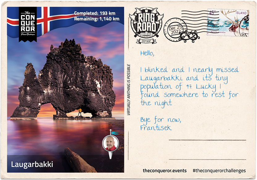
Having made it on Vatnsnes Peninsula, I was particularly interested in seeing the Hvítserkur rock formation that some refer to as an elephant shape and others as a rhino. I think it looks more like a triceratops drinking water. A little more lore, it is said that the rock formation is really a troll frozen in the light of day. This 15m (49ft) tall basalt rock protrudes from Húnaflói Bay and is the nesting ground for various birds. The three large holes may have been carved by cascading sea water but its foundations have become brittle and it has since been reinforced with concrete to protect it.
I finished my day with a picnic watching the seals lazing on the rocks and the pups playfully frolicking in the water.
Regards,
Frantisek
km od začátku : 0299
Varmahlíð
Travelling through Vatnsskarð mountain pass on the way to Varmahlíð, I came across Stephan G. Stephansson's monument. Stephan was a renown Icelandic poet and farmer from the region who suffered from insomnia. As such he would write all night after finishing his farming work. A self-educated man, he only wrote in Icelandic even though he emigrated when he was 19 years old to Wisconsin, USA and later to Alberta, Canada. He returned to Iceland for the first time 45 years later when he was 64 years old and although none of his poetry has survived only his letters, he is highly regarded and considered "as one of Iceland's foremost men of letters".
The village of Varmahlíð is home to 140 residents. Small it may be but it is not to be underestimated. Living on the slope of a hill, the village is in the centre of the most prosperous agricultural region, rich in geo-thermal water and contains a number of greenhouses that grow tropical and sub-tropical fruit and vegetables.
The village is home to Iceland's most famous men's choir, Karlakórinn Heimir. Originally founded in 1927 it travels the world singing. In its 93 years, the choir has only had three conductors of which the second conductor held his position for 40 years.
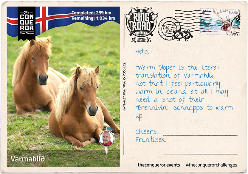
The region's main industry is the Icelandic horse. A pure breed described as small almost pony-like, yet sturdy and hardy horse. Native to Iceland they have few diseases and due to Iceland's strict no horse-import policy they are not vaccinated against potential diseases. Although Icelandic horses are exported, once they leave the country they cannot return. Unique to these horses are their gaits. Known for their sure-footedness and ability to cross rough terrain the horses have an additional two gaits. Although difficult to articulate have a look at this link that describes their special gaits and history on how they arrived during the Viking Age in the 9th-10th centuries. https://en.wikipedia.org/wiki/Icelandic_horse
Just north of Varmahlíð is the Glaumbær Farm and Museum, exhibiting 18th-19th centuries rural living in turf-roofed farmhouses. Turf was used as building material which first appeared over 1,000 years ago when the Vikings arrived. As timber was sparse and slow to regrow, the Vikings used turf to lay over a timber structure to form walls and a thick roof. The turf was sturdy and easily available providing insulation from the cold climate. However, due to its biodegradability and erosion from the harsh climate the turf needed to be replaced every 20 years.
Of course no daily trip is complete without a stop at a waterfall. Only 7km (4mi) from Varmahlíð, is Reykjafoss waterfall which is a result of Huseyjarkvisl river cascading 20m (69ft) over two wide steps into the river below and flowing onwards to the Atlantic Ocean. The Huseyjarkvisl river is one of the top sea trout rivers. Large fish are caught each year with one of the biggest measuring 96cm (3ft) and weighing as much as 6kg (13lb). Catch and release practices were introduced in 2000 which is one of the reasons for such large fish and the double digit catches.
Bye,
Frantisek
km od začátku : 0394
Akureyri
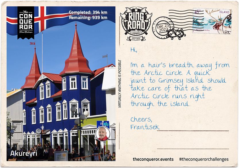
I've arrived in Akureyri, the largest town outside the heavily populated south-west corner of Iceland. Nicknamed the capital of North Iceland, Akureyri was originally settled in the 9th century by Norse Viking Helgi Eyvindarson. Danish merchants used it as a trading port during the 17th century but always returned to Denmark during the winter. Permanent settlement began in the 18th century largely due to the ice-free nature of the port and rich agricultural conditions in the region.
During WWII, Allied units were based in town and the Norwegian-British squadron had an airbase here. The squadron flew Northrop N-3PB bombers and Catalina flying boats to protect convoys between US, UK and Murmansk in Russia from German submarine attacks.
Akureyri has a strong folk culture and it is home to Vefarinn, the folk dancing group. Each year the town hosts several festivals such as: Vaka Folk Arts Festival with performances from folk musicians and dancing groups like Vefarinn; and, the Medieval Festival held at Gásir, a trading post from the Middle Ages where a medieval market is held annually and visitors can experience the culture and occupations of the Middle Ages.
Eight main museums can be found in this small northern town. Anything from aviation, art, industrial history, folk art, literature to 20th century toys, motorcycles and general regional history. There's no shortage of history and exhibitions. Just consider the 28 full-sized aircrafts in the aviation museum or the motorcycle collection that tells its 100-year history since the first motorbike arrived on the island. The toy museum may be nostalgic but the building itself was once owned by the Independent Order of Good Templars (a sector of the Freemasons).
For a round of golf, the Akureyri Golf Club holds the title of the most northerly golf course in the world. Established in 1935 it is the second oldest club in Iceland. The Arctic Open is held here during the summer as a four-day championship event. Given the proximity to the Arctic Circle, I think a round of golf under the midnight sun is in order.
Cheers,
Frantisek
km od začátku : 0477
Reykjahlíð
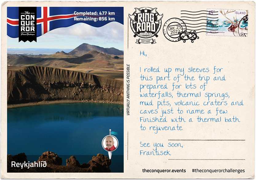
When I arrived in Reykjahlíð I rolled out my map and pinned everything I wanted to see in this area that didn't include the two waterfalls I had to see halfway between Akureyri and Reykjahlíð. There is no end to the breathtaking scenery in this country. So grab a cuppa and let me regale you with my exploits.
On my way to Reykjahlíð, I took a very short detour at Fossholl to checkout Goðafoss. It is a 30m (98ft) wide curved waterfall with a 12m (39ft) drop. Legend says that a lawmaker, who was also a pagan priest, meditated for one day and night and decided in favour of Christianity. When he returned home, he threw his Norse god idols into the nearby waterfall which is now known as Goðafoss, "the waterfall of the gods". The story is illustrated in the window of Akureyri's main church. A further 500m (1,640ft) below Goðafoss is the smaller Geitafoss at about half the width and height which is thought to be swallowed up when the depth of the river increases within the gorge due to floods.
When the volcano Krafla erupted 300 years ago, the townspeople of Reykjahlíð fortunately survived as they huddled in the church up on higher ground where the lava flow stopped. The town itself was completely destroyed. Thankfully today I can use it as a place to visit the nearby natural wonders.
I started with the Myvatn volcanic lake. With its high level of biological activity it provides a habitat for waterbirds such as ducks (15-16 species of duck). The lake began 2300 years ago when a basaltic lava erupted. South of the lake are pseudocraters (aka rootless cones) which look like volcanic craters but are actually formed by steam explosions when flowing lava crosses a wet surface like a lake.
There are many hot springs in the area with contradictory advice if swimmable or not but the following two are worth exploring. Stóragjá for instance is an ancient subterranean cave filled with naturally heated thermal springs. It is a bit of an adventure climbing down a very narrow ravine before clambering into the cave using ropes followed by carved steps. The beautiful blue colour of the water is very inviting but the dangerous algae and lack of filtration makes the spring unsafe for bathers.
The more popular Grjótagjá Cave rose to fame after its appearance in an episode of Game of Thrones. It used to be a popular bathing location until the mid-70s when following an eruption the water temperature rose beyond 50°C (122°F). Due to the liquid rock a mile beneath the surface the temperature remains high making swimming unsafe.
Once I surfaced from the subterranean caves, I took a hike onto Hverfjall Crater. Described as a tephra cone or tuff ring volcano, it is one of the largest of its kind in the world due to its 1km (0.6mi) diameter. The 396m (1300ft) walk up a steep path and around the crater's rim provides a great view of the Myvatn region and nearby lava fields.
The Myvatn Nature Baths is beckoning me for a leisurely steam bath in its alkaline lagoon but first one final stop at Hverir to see the boiling mud pits and steaming fumaroles that emit sulphuric gases. The pits are surrounded by colourful sulphur crystals which unfortunately give off a strong egg-like smell. The area's high acidity levels inhibits vegetation from growing.
It's time for my geo-thermal soak.
Cheerio,
Frantisek
km od začátku : 0642
Eggilstaðir
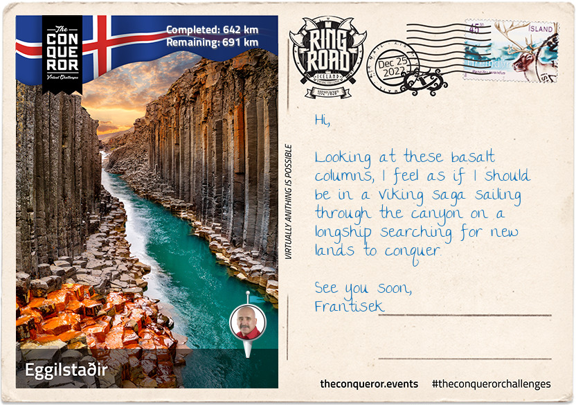
Along the second longest river on the island, known as Jökulsá á Fjöllum, are three substantial waterfalls; Selfoss, Dettifoss and Hafragilsfoss in close proximity. This glacial river is 206km (128mi) long and flows into the Greenland Sea. Its source is Vatnajökull, the largest ice cap in Iceland that covers 8% of the country.
The most spectacular of the waterfalls is Dettifoss. Incredibly powerful with its 44m (144ft) drop and 100m (330ft) width it is also deafeningly loud. The waterfall can be seen from both the west and east banks and on a good day a rainbow may be seen from the west bank. Selfoss, much smaller, is only a kilometer away upstream. Although it doesn't have the same volume or power and is only 10m (32ft) tall, Selfoss is much wider than Dettifoss and best seen from the east bank since most of the water flows from the west. Hafragilfoss is downstream of Dettifoss and just as powerful with its single 27m (89ft) drop.
My next stop was the Jökuldalur Valley, known for its forceful glacial river and basalt column canyon. The river used to roar its way from the Highlands, cutting through the valley which for many centuries due to its force and high level made crossing it inaccessible and very dangerous. However, in 2009 the river's source was diverted by a hydroelectric plant and created the Hálslón reservoir. From the reservoir the river flows with the same force for 60km (37mi) in underground tunnels to drive the hydroelectric turbines of the power plant.
What's left of the original river course is now fed from surrounding mountains, creeks and small rivers. No longer a glacial river carrying 120 tonnes of sand, mud and dirt, it is now a clear, blue river flowing to its final destination. The greatly reduced water level has exposed the basalt columns that makes up Stuðlagil Canyon. These hexagonal columns are a result of basaltic lava slowly cooling over time and as the columns shrink in volume they crack creating these symmetrical columnar patterns. The canyon is also home to pink-footed geese during nesting season when they lay their eggs along the gorge. A little further down is Stuðlafoss, a waterfall that cascades down moss-covered basalt columns. The shorter columns at the bottom stack in front of each other resembling an ancient throne.
When you think of Iceland, it probably conjures images of ice caps, glaciers, barren land, volcanoes but not of trees or forests. So it's hard to imagine that once, Iceland was heavily forested when the climate was warmer and the glaciers were smaller. Then the Vikings came and since trees were their main source of building materials for housing and boats and smelting metal, the forests diminished over time. Native trees were mainly birch with some rowan, willow and aspen trees. At the turn of the 20th century reforestation projects and woodland planting schemes commenced and have been ongoing ever since. Near Eggilstaðir is Iceland's largest forest, Hallormstðaskógar, covering 740 hectares. The forest has 40km (24mi) of hiking trails and a tree museum consisting of 70 species of trees. The most delightful part was being able to collect edible mushrooms and pick raspberries and redcurrants. When I ran out of water I was able to refill my bottle directly from the stream as it's clean and drinkable.
See you soon,
Frantisek
km od začátku : 0787
Djúpigovur
Having reached east of Iceland, my journey took me through a jagged coastline of fjords. Although Egilsstaðir is the largest town in this region, Djúpigovur is the oldest municipality by receiving its trading license in 1589. Located on a peninsula between two fjords, the town is home to the oldest commercial building in the country known as Langabúð (early 19thC). Today the building is a café, heritage museum and has an exhibition on local sculptor, Ríkarður Jónsson who in 1918 won a competition to create a new coat of arms for Iceland.
Not far from town is an outdoor art installation called, The Eggs of Merry Bay. Along the bay are 34 large replica eggs that are meant to be a tribute to the native birds of Iceland. Each egg, set atop a concrete slab, "depicts the shape, patterns and colours of the individual bird egg it represents". With the exception of one, the eggs are all close in size. The larger singled out egg, was the sculpture honouring the red-throated diver which is the official bird of Djúpigovur.
Classified as a "Cittaslow" town, Djúpigovur is the first and only one in Iceland. Cittaslow is a cultural trend towards slow movement. Founded in 1999 Italy, Cittaslow's aim is to improve the quality of life in towns by slowing down the pace, promote healthier lifestyles, environmental protection, cultural diversity and resist cultural standardisation. Djúpigovur is one of 192 Cittaslow towns around the world.
The nearby Papey Island was settled by two monks who might have fled Norse attacks on the mainland and founded a hermitage. The island's name is Celtic, meaning "Friar's Island". It has the oldest wooden church in the country. Uninhabited since 1948 when the last resident left, it is a great place to see puffins, guillemots, other birds and seals.
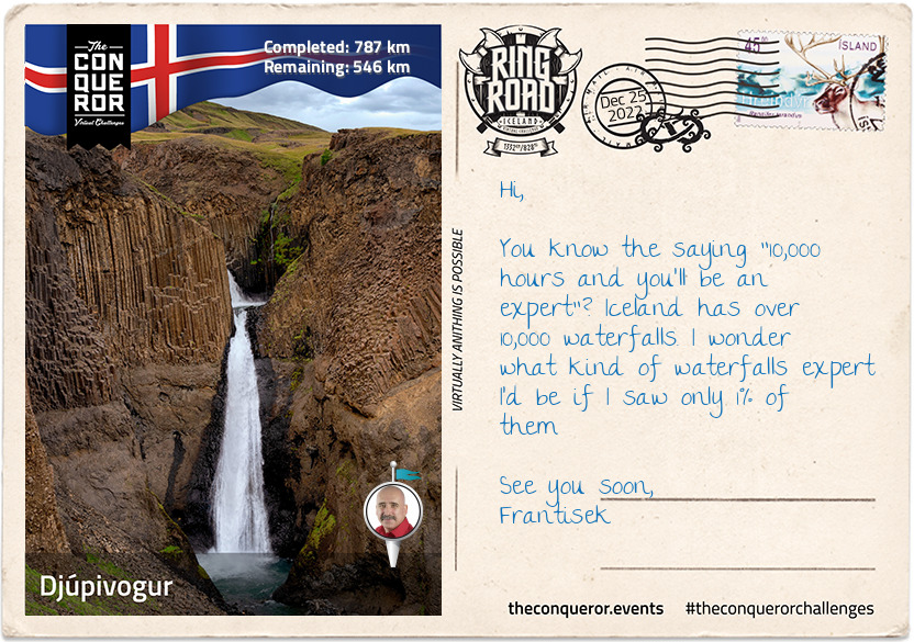
"Climbingslopewaterfalls" is the literal translation to Klifbrekkufossar, a waterfall that looks like a series of waterfalls one above the other falling from a 90m (295ft) height but Klifbrekkufossar is a singular waterfall that lands on a series of ledges before winding itself down the river. Being spring-fed the river is not contaminated by dirt, like glacial rivers, thereby making the water clear and clean giving the waterfall a sense of purity.
See you soon,
Frantisek
km od začátku : 0885
Höfn
I chose Höfn, a town slightly south of the Ring Road, because I wanted to visit Vatnajökull National Park. What I didn't expect was a thriving community with excellent modern services, a strong fishing and agricultural industry and rapid growth in tourism.
Historically speaking Höfn is a relatively new town unlike the others I've travelled through that can trace back their history for centuries. It has a harbour surrounded by sea on three sides that is usually difficult to navigate due to shifting patterns of shoals. Regular dredging is needed to remove excess sand from the harbour so ships may safely moor.
Across Skarðsfjörður Bay is Stokksness Peninsula and the dramatic Vestrahorn mountain. At the tip of the peninsula is a radar station used by Iceland's Air Defence System to monitor their airspace. Vestrahorn is a 454m (1,489ft) tall scree mountain largely made up of subvolcanic rock. The scree formation is a result of water flowing into rock walls and freezing due to temperature fluctuations. The frozen water then splits and splinters the bedrock which then tumbles to the base of the steep slope accumulating as loose rock.
Between the peninsula and the mountain is a beach with black sand and green tufts of grass sprouting from it. The beach got very dark at night making it a great spot to see the Northern Lights. The black sand is a result of volcanic activity. It is formed by rapid cooling of lava when in contact with the sea. The lava then shatters and breaks down into small particles until it looks like sand. Unlike normal sand that is hardier and more resistant to weathering, black sand continues to break down. A by-product of this breakdown is that shores become deep very quickly making waves behave differently to what we may be typically accustomed to elsewhere. Common advice I hear is to keep a substantial distance of at least 30m (100ft) from the shore in case a rogue wave that is much larger and reaches much further up the shore sneaks up on the unsuspecting visitor.
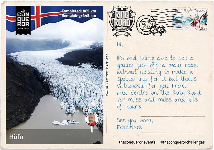
Finally let me tell you about Vatnajökull, Europe's largest glacier. Covering an area of 8,100 square km (3,127sq mi) in some areas the thickness of the ice cap is anywhere from 400 to 1100m (1,312-3,280ft). Beneath the ice is a landscape of valleys, canyons and gorges. Highly active volcanoes also hide beneath with Grímsvötn being the most active. Its last eruption in 2011, caused multiple earthquakes and an ash cloud rising to 20km (12mi). Vatnajökull has 30 glacier tongues which are huge sections of the glacier falling from the top of the ice cap, down a long slope, at a very slow pace and as it reaches the bottom the glacier tongue starts breaking and forming deep cracks with enormously loud noise eventually ending in a lake or the ocean.
See you soon,
Frantisek
km od začátku : 0996
Hof
On the way to Hof, Iceland the Ring Road crosses over the famous Jökulsárlón glacial lake. It is the deepest lake in Iceland at 284m (932ft) and as a result of glacial melting it has grown fourfold since the 1970s. As icebergs calve from the glacier's edge they start floating towards the sea. Waves polish the icebergs and float them onto the black sands of Breiðamerkusandur, a glacial outwash plain. It is nicknamed Diamond Beach, because the polished ice on the black sands look like diamonds glistening in the sun. Due to floating icebergs in the lagoon the bridge is reinforced with a row of stone boulders that prevents the icebergs from hitting the pillars and stops the foundations from eroding.
When I arrived in "Hof, Iceland" I was very curious about why the name Iceland is tagged on the end of Hof. It's the only village in Iceland that seems to carry the name like this. I couldn't find an answer but what I did discover is how new this village is. Hof, Iceland was nothing more than a collection of farms until 2017 when increased tourism created a shortage of housing in the region. The local government wasted no time and commenced building new streets and housing around the already existing primary school.
The village's church has been there since 1884 and it was the last turf church ever built in Iceland and the only one that continues to be a practising parish. Looking at the church from the rear it looks as if it's sinking but it's actually partially buried in the ground in order to use the earth as natural insulation.
The village is in the foothills of Ӧræfajökull glacier which covers the largest active volcano that last erupted in 1727. At 2,110m (6,955ft) the volcano is the highest peak in Iceland. The volcano has phreatic eruptions which happens when magma heats ground water. The magma's extreme temperature causes "near-instantaneous evaporation of water resulting in an explosion of steam, water, ash, rock and volcanic bombs" which then deposit in the surrounding areas. The volcano's 1362 eruption destroyed everything in the region and deposited 10km³ (2.4mi³) of volcanic material. It took 40 years to resettle the area. Unsurprisingly the region's name was changed to Ӧræfi, meaning "wasteland".
North of Hof, Iceland is Svartifoss a slender 20m (66ft) high waterfall. The beauty of this waterfall is the geometric rock face being a 3D wall of hexagonal basalt column. These columnar joint formations are often an inspiration for Icelandic architecture such as the main church in Reykjavik.
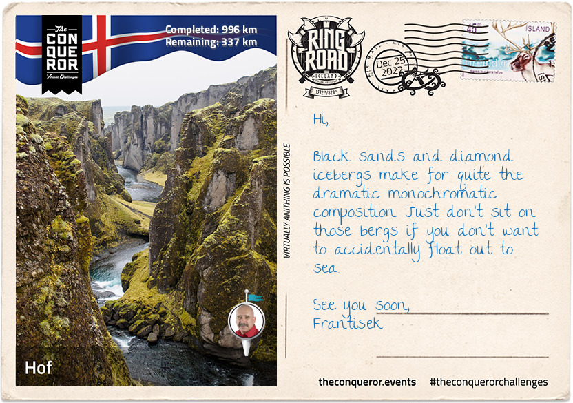
Fjaðrárgljúfur is an ancient, massive river canyon with steep walls up to 100m (330ft) high and water winding its way through the canyon for at least 2km (1.2mi). Its origins date back two million years when the pressure of flowing water from glaciers cut through the bedrock creating these deep channels with steep valley walls. Sadly the canyon's environment was threatened due to the influx of visitors and the authorities closed access to the canyon.
See you soon,
Frantisek
km od začátku : 1151
Vik
In the shadow of Mýrdalsjökull glacier sits the tiny seaside village of Vik. It only has 300 inhabitants but it is not short of services for the locals and tourists. Vik has much to offer and most of it all within walking distance.
Starting in town, Vik is rich in maritime history but quite surprisingly has never had a harbour, largely due to strong waves and shallow shores making it too difficult for ships to navigate without stranding. However, the nearby museum centres around Skaftfellingur, a trading ship that serviced the south coast for 20 years (1918-1939). Renown for saving a crew in 1942 from a German submarine, the ship was salvaged in its entirety in 2001 and made available to see in the museum.
Up on the hill is the famously photographed Vikurkirkja Church. With its white walls and red rooftop, the church is a safe haven should the highly active volcano, Katla, erupt. Katla is covered by Mýrdalsjökull's ice cap and it erupts every 40-80 years (16 eruptions have been recorded to date). Although the last eruption was in 1918, scientists predict that an eruption may occur soon. Should that happen, the concern is that it would cause a flash flood big enough to annihilate the whole town, hence making the church the safest place to be.
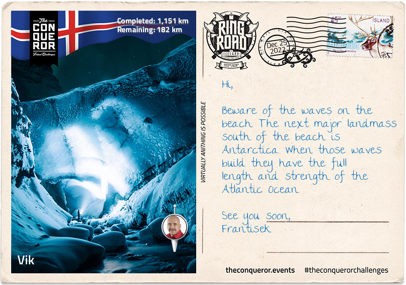
If having an active volcano beneath a substantial glacier isn't impressive enough then imagine an ice cave beneath the volcano. It is referred to as Katla's Ice Cave Dome. With crampons on, I climbed a few steps on ladders to the entrance of the cave where I was greeted by a narrow snake-like ice tunnel before entering the dome. The opening that formed in the ceiling made me feel like I was standing in a cathedral. In 2018 a secondary cave was discovered inside this one when a new opening was found. I'm told that ice caves are an ever-changing phenomenon making each visit different from the last.
Black sand beaches permeate through southern Iceland or anywhere with volcanic activity since the sand, as I mentioned in my letter from Höfn, is cooled lava shattered into small particles. However, the black sand beach of Reynisfjara, a short walking distance from town, is the most famous. It provides access to Reynisdrangar, two basalt sea stacks that are all that's left of a cliff (just like the 12 Apostles on Great Ocean Road, Australia). In folklore the stacks are said to be two trolls who unsuccessfully tried to drag a three-masted ship to land and when daylight hit they became needles of rock.
See you soon,
Frantisek
km od začátku : 1244
Hella
Hella is another reasonably new community and a great base to slow down, rejuvenate and visit the surrounding area. It started in 1927 with a store being built near the bridge that crosses the Ytri-Rangá River. A decade later the store was bought by a co-op society and moved into other businesses and by the 1950s it was a flourishing little town that continued to grow and develop bringing more services such as schools, community centre, sports centre and an administrative building. Today the town's economy is dependent on service and tourism.
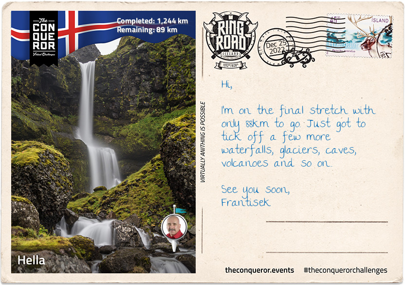
A short easy hike away from the bridge, I came across Ægissiðufoss waterfall. Nothing like what I've seen throughout Iceland so far, a tall, menacing, powerful falls, but it is wide and cascades over a couple of layers into Ytri-Rangá River that flows onwards into the Atlantic. The river itself is popular for salmon fishing and a great foreground for photographic composition with Mount Hekla in the background.
Hekla is a very busy volcanic mountain. At a height of 1,491m (4,892ft) it has erupted more than 20 times in the past 1,100 years and during the Middle Ages it was called "Gateway to Hell". Due to its frequent eruptions, the tephra layers that covered about 10% of the land are now used to date other volcanoes in the country.
Hiking is a popular pass time on Hekla especially since the path leads up to the summit. The first ascent was in 1750 completed by two students. Although the path is marked up to the halfway point the rest of it is on a broad ridge walk with half of that on snow. The hike passes three craters along with some steaming sulphur.
Hekla also has a pastry named after it. It's an upside-down cinnamon roll with icing sugar drizzled over the top to look like the snow-topped volcano. Much as I'd like to have one the nearest bakery for this specialty is Boston, Massachusetts.
See you soon,
Frantisek
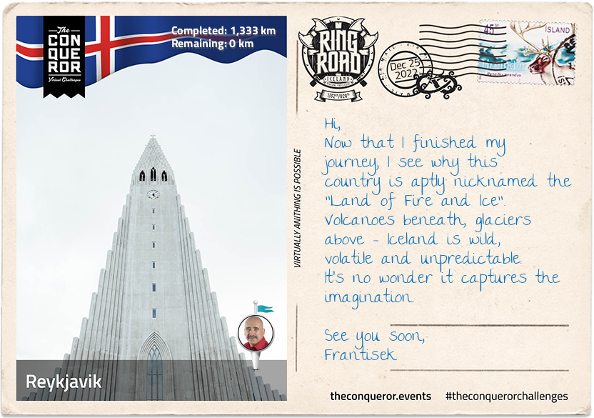
km od začátku : 1333
Reykjavik
I have completed my 1,332km (828mi) journey around the Ring Road of Iceland finishing at the Árbæjarsafn Open Air Musuem, a historical museum about Reykjavik. The museum was born as a result of concerns that the city's historical legacy is disappearing. Built in 1954 the museum provides an insight into the lives and work of the people pre-20th century through displays of various types of buildings and cultural artefacts.
Any art or architecture enthusiast would revel in the exploration of The Einar Jónsson Museum. The first art museum in Iceland, it was the pipe dream of Iceland's first sculptor Einar Jónsson. Einar gifted all his works to the country on the proviso that a museum was built for them. Although the gift was initially rejected, following fundraising between Parliament and private contributors the art museum came into existence in 1916. The building, designed by Einar, is as much a sculpture as all the works it holds within its walls. The nearby sculpture garden is keeper of 26 bronze casts of his works. Einar worked with clay and plaster and in order to protect them the museum actively turns the sculptures into bronze casts. I also found many of Einar's works just meandering around the city.
No Reykjavik visit is complete without seeing Hallgrímskirkja, a parish church and national sanctuary 41 years in the making. At 74m (244ft) high, it is the largest church and one of the tallest structures in Iceland. It is an architectural feast with a façade reminiscent of the basalt column rock formations found throughout the island.
Outside the church is the statue of explorer Leif Erikson, which was a gift from the United States commemorating the 1000th anniversary of Iceland's parliament. Leif was a Norse explorer from Iceland and considered to be the first person to reach the North American continent around 1000AD.
Now if I had the time I'd swing by the Golden Circle for a few days to see the Thingvellir National Park which is also a UNESCO site. Thingvellir is a rift valley where the North American and European continental plates separated. The nearby Thingvallavatn, is the largest natural lake in Iceland and reaches depths of 114m (374ft). On the northern shore of the lake is Silfra, a fissure filled with incredibly clear blue water. A perfect site for scuba diving and snorkelling. One of the diving sites is 100m (328ft) long with clear visibility from end to end.
However, I must end the journey here and as I travel homewards, I'll happily reflect on the natural and beautiful wonders I've experienced on this trip.