In the southwest corner of Ireland, on the Iveragh Peninsula, is the 200km circular route known as the Ring of Kerry. Following the contour of the land, the route is a panoramic feast of mountains and lakes, passing through rural seaside villages.
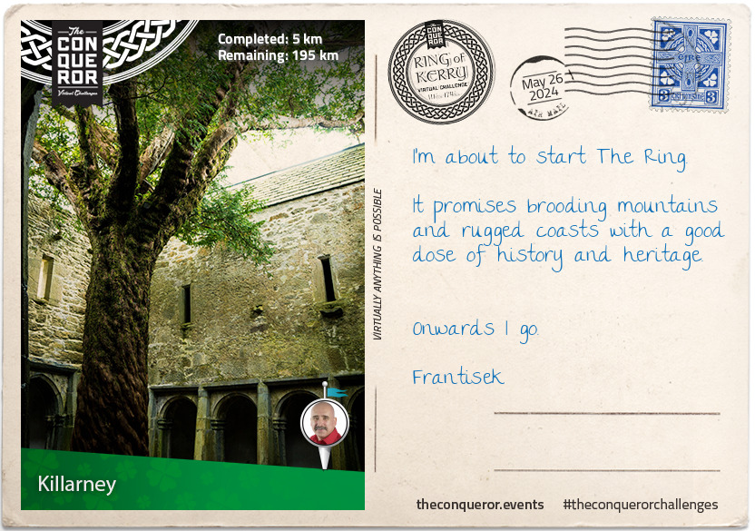
Your journey begins in Killarney, a popular destination due to its many wonderful attractions. Here you can indulge in hiking, horse and carriage rides, explore medieval abbeys or castles, absorb the mountaintop views overlooking lakes, watch waterfalls cascade and if you're lucky see red deer roaming through the oak woodland.
The town is located on the edge of Killarney National Park which is Ireland's first park. Established in 1932, the park was previously known as Bourn Vincent Memorial Park (named after the benefactors) and gained National Park status and protection in the 1970s when concerns over its preservation was threatened. At 103km² the park's major objectives are conservation and ecosystem protection and as such has obtained the UNESCO Biosphere Reserve status in 1981.
Within the park you will find the grand 65 room Muckross House overlooking Muckross Lake. Designed by Scottish architect, William Burns, and built mid-19th century, this Tudor style house is furnished in period style illustrating the elegant lifestyles of landowners at the time. The house changed hands several times until 1932 when the last owners, the Bourn-Vincent family, donated the property in its entirety to the Irish state. Today the House is open to the public hosting tours, events and spinning and weaving demonstrations. The House's research library is home to the Centre for Collection, Storage and Preservation of documentary material relating to Kerry.
A short walk away from the House sits the 15th century Muckross Abbey, a Franciscan Friary whose monks were driven out in the 1650s by Cromwell's forces during the Wars of the Three Kingdoms. Although damaged and rebuilt many times, the ruins of the abbey are in reasonable shape and well preserved. A vaulted cloister surrounds a square courtyard which within its centre holds a 550-year-old yew tree.
km od začátku : 0033
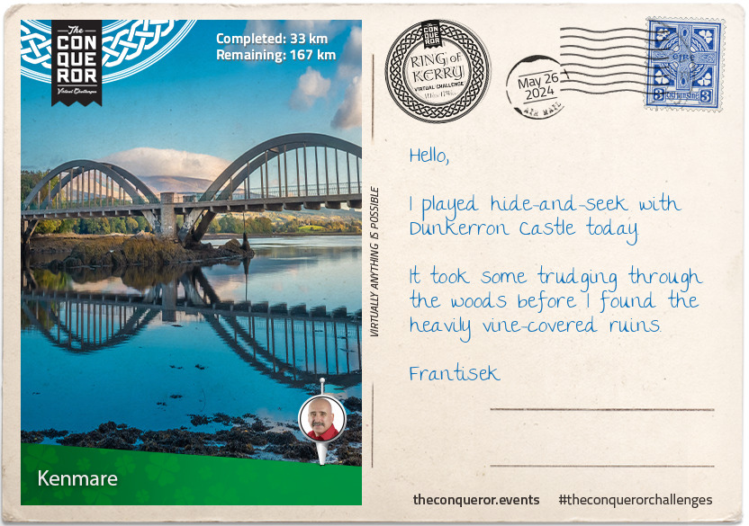
Kenmare
Seen as the gateway to the Ring of Kerry and Beara Peninsula, Kenmare is a coastal town nestled amongst mountains and situated on the estuary of Kenmare Bay.
Established in the late 1700s, archaeological studies date the area back to the Bronze Age. The nearby Stone Circle comprising of 15 stones laid out in an egg-shape indicates a presence of 3000 years. Perfectly aligned with the sun, it is thought to be used as an agricultural calendar.
The town developers gave Kenmare a unique triangular shape with the three main streets connecting to each other. Kenmare is also the recipient of the first suspension bridge in Ireland. Built in 1841, due to heavy traffic and mounting ongoing problems the bridge was replaced 90 years later with the current iconic wrought iron and concrete bridge.
Suffering greatly during the Irish famine of the mid-19th century, upon the request of a local priest, seven nuns arrived to open a school believing the best way to improve the residents' future was through education. A convent building was erected by 1862 which continues to exist as a place of education with a secondary school moving in 2001.
To develop a source of income girls were taught lacemaking and embroidery, whilst boys were taught woodworking and leather work. Over time Kenmare Lace became internationally renowned for its craftsmanship and intricate design. It continues to be an important part of Kenmare today.
For the outdoorsy person, Kenmare is host to a number of activities such as beach horseriding, archery, diving, golf, deep sea angling and water sports. Nicknamed as the "Walking Mecca of Ireland", Kenmare offers a combination of town heritage walks or for something more strenuous several routes of different grades can be experienced in the nearby mountains. Even the competitive athlete will find local running and cycling races or the annual Little Bo Peep triathlon.
km od začátku : 0092
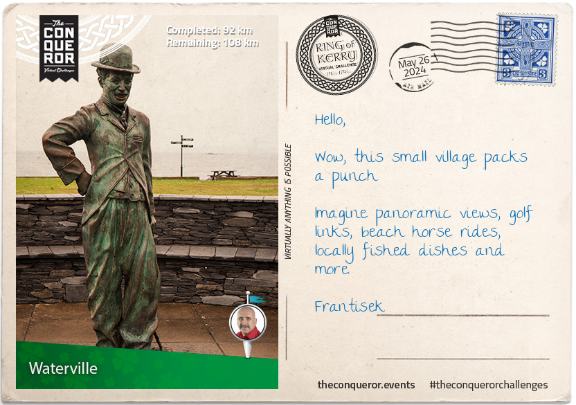
Waterville
Between Ballinskelligs Bay and Lough Currane (lake) on a narrow isthmus lies the coastal village of Waterville. Flanked by two championship 18-hole golf courses, one to the north and the other to the south, this small town of 496 residents is a bundle of surprises.
Waterville began as a village in the 1800s and although it remains a small village, you will never be short of something outdoorsy to do. There's a plethora of walking and cycling routes with both easy and difficult levels. The Equestrian Centre conducts pony camps, horsemanship courses and beach rides. The Sea Synergy is a marine awareness and activity centre, with their main objective to educate about marine life and ocean conservation. Operated by marine biologist and ecologists, the organisation runs educational adventure tours and summer camps for kids and teens.
A walk on the promenade will bring you to a statue of Charlie Chaplin who enjoyed Waterville so much that for a decade he returned every year for holidays with his family. Obtaining permission from the Charlie Chaplin estate, Waterville hosts the annual Charlie Chaplin Comedy Film Festival.
When the first transatlantic cable was installed in 1858 between Newfoundland Canada and Valentia Island near Waterville it didn't come without its problems. Working for a mere three weeks due to weak cables, it took five further attempts across nine years to eventually succeed in maintaining a lasting connection. The Atlantic Telegraph Co. had a monopoly over the industry and as a result the Commercial Cable Company from New York was established to break the monopoly and reduce prices by successfully installing cables in 1884 from Waterville to Nova Scotia. This brought a hive of activity into the village and the need for more housing to accommodate company personnel who settled in the area. Waterville became the European hub for the Company and at its peak was the largest cable station in the world.
km od začátku : 0121
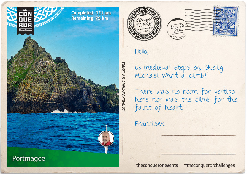
Portmagee
As you make your way towards Portmagee, you'll be veering off the Ring of Kerry onto a small country road called the Skellig Ring. An extension of the Ring of Kerry, this quiet coastal route with the ever-present Atlantic Ocean to the left, takes you through small villages and mountains of the Iveragh Peninsula.
Along the way make a pitstop in the village of Ballinskelligs and walk in the footsteps of the Skellig Monks along the foreshore to the 12th century abbey. The abbey became the land base for the monks who came from Skellig Michael island. From the Abbey a short walk away is McCarthy Mór Tower, thought to be a 16th century tower house on a small isthmus that once belonged to the McCarthy's, chieftains in Cork and Kerry at that time.
As you continue on lookout for the 1000ft high Kerry Cliffs with uninterrupted views of Puffin Island, an uninhabited island home to numerous seabirds and puffins; Skellig Islands, two uninhabited islands of which the bigger one known as Skellig Michael, is the site of a 6th century Christian monastery; and the wild Atlantic waves crashing against the cliff-face.
Arriving in Portmagee, the first stop for any chocolate enthusiast must be at the Skellig Chocolate Factory, Ireland's only open-plan chocolate factory. Handmade onsite in an open-plan design, visitors are able to interact directly with the chocolatiers whilst tasting samples.
From here, take a boat trip to Skellig Michael and climb the 618 medieval steps to the top. Rising to fame as the island sanctuary to Luke Skywalker in 2015’s Star Wars: The Force Awakens, Skellig Michael has a long history. A twin-pinnacle crag, it came into existence some 360+ million years ago. Originally part of a mountain range and connected to a continental landmass, it became separated with rising water levels. Around the 6th century an Augustinian monastery was built for monks who appreciated the island's isolation and available rock for construction. Continuously occupied until the 12th century, it is estimated that only 12 monks and an abbot lived on the island at any one time. The island was eventually abandoned as a result of several factors such as colder and stormier climate, ongoing Viking raids and changing structure of the Irish Church. Skellig Michael entered the UNESCO World Heritage List in 1996.
Valentia Island is linked to Portmagee by a bridge. Valentia is better known for its first successful and commercially viable transatlantic telegraph cable. Connecting to Newfoundland, Canada the trans-Atlantic undersea cable opened up a faster and more reliable form of communication between Europe and North America. Prior to the telegraph cable, communication was undertaken via ship. Depending on weather, particularly during severe winter storms, communication by ship would take several weeks to reach their destination. With the telegraph cable installed, messages were received and responded to on the same day. The transatlantic cables in Valentia remained in operation for one hundred years when the owners, Western Union, terminated cable operations in 1966.
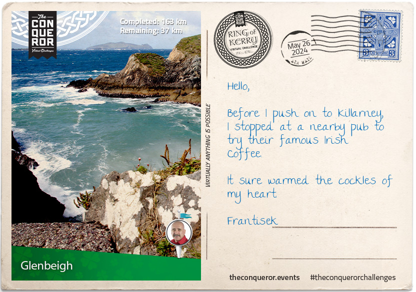
km od začátku : 0163
Glenbeigh
Glenbeigh is a small civil parish nestled amongst the hills with rivers Caragh and Behy flowing on either side of it into Castlemaine Harbour.
With a mere population of 308, you may think it a small sleepy town but Glenbeigh is a popular tourist destination. Besides being on the Ring of Kerry it is home to the pristine Blue Flag award Rossbeigh Beach. A long sandy beach which annually hosts a Horse Racing Festival, Rossbeigh has fallen victim to high tides, wild storms and consequently sand erosion. In 2008 the beach had lost 1200 feet of sand dunes. It is estimated that since 2008 a further 10-15 million tonnes of sand has been lost raising concerns that without pro-active action the beach will eventually disappear.
Rossbeigh Tower, located at the end of Rossbeigh Beach was the beacon for safe navigation into Castlemaine Harbour for 150 years. Following heavy storms off the Atlantic Ocean it gave way and collapsed in 2011. After five years of campaigning, including salvaged parts of the original tower, a replica was built in the town centre as a way to preserve the history and heritage of the tower.
This wasn't the end of surprises for the Glenbeigh residents. In early January 2014, Cyclone Christina left a trail of damage on the coasts of Ireland but on Rossbeigh Beach it fully unearthed a partially submerged 19th century schooner that has been buried for a hundred years. The schooner named, The Sunbeam, was built in 1860 England and was on a voyage shipping flour when it shipwrecked in 1903, fortunately with no loss of life.
In a field near Glenbeigh parish, stands the ruins of Wynn's Castle, an 18th century castellated mansion. The exorbitant cost of building the castle was funded by rental income earned from the estate. The higher the costs went, the higher the rental increases. Tenants who were no longer able to meet their rental expenses were unfortunately evicted by the owner who himself eventually became insolvent and left Glenbeigh. During WWI, the castle was used as a training centre for reservists of the British Military Command and by 1921, the castle was burnt to the ground by Irish Republican forces and was never rebuilt.
Before you leave Glenbeigh to make your final trek back to Killarney, stop in at one of the local pubs for a traditional Irish Stew and a pint of Guinness. Finish with an Irish Coffee, the coffee and whiskey combination that was created by Chef Joe Sheridan in 1943 at Foynes Port near Limerick.
Joe Sheridan's recipe for a true Irish Coffee:
Cream - Rich as an Irish Brogue
Coffee - Strong as a Friendly Hand
Sugar - Sweet as the tongue of a Rogue
Whiskey - Smooth as the Wit of the Land
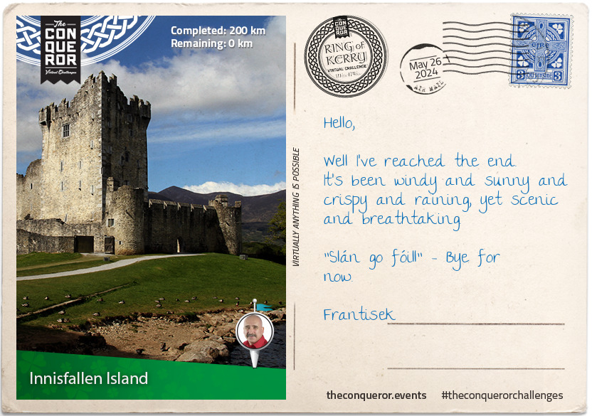
km od začátku : 0200
Innisfallen Island
Congratulations, you have completed Ireland's well known scenic route the Ring of Kerry. Before you leave spend a little more time in Killarney by visiting the historical site of the 15th century Ross Castle.
Overlooking the third largest lake in Ireland, called Lough Leane, the castle was built by the local ruling clan, O'Donoghues Mór. Ross Castle was one of the last castles in Ireland to surrender to Cromwell's forces. Up until the 17th century the castle was surrounded by a curtain wall with towers in each corner. A portion of the curtain wall was torn down to make way for expansion whilst in use as a barracks. Today the castle is open to visitors, retaining the tower house, part of the curtain wall and two towers.
From the castle take a boat ride on the lake to Innisfallen Island, the home to the ruins Innisfallen Abbey. Founded in 640 AD by St Finian, the patron saint of the area, it was occupied for nearly a thousand years. Nothing remains from that early settlement. The current ruins are a late 12th century Augustinian Priory. Over a few hundred years the resident monks wrote the famed Annals of Innisfallen, a chronicle of Ireland's medieval history. In the late 16th century during Queen Elizabeth I's reign, the monks were dispossessed of their abbey.
An excerpt from Thomas Moore's poem entitled Sweet Innisfallen (c1870) describes it best:
Sweet Innisfallen, fare thee well,
May calm and sunshine long be thine!
How fair thou art let other tell,
To feel how fair shall long be mine.
Sweet Innisfallen, long shall dwell
In memory's dream that sunny smile,
Which o'er thee on that evening fell,
When first I saw thy fairy isle...