What images come to mind when you hear the phrase "Silk Road"? For me, the Silk Road conjures images of camels laden with goods, crossing endless deserts beneath vast, starry skies. Brave travellers embarked on long journeys to exchange knowledge and ideas, while merchants embraced the dangers, hoping to make their fortunes through trade. Yet, it's fascinating to think that most merchants didn't traverse the entire route from East to West. Instead, goods were traded in stages, passing through many hands, each merchant specialising in a particular segment of the journey. In contrast, explorers like Marco Polo ventured the full length of the Silk Road, driven by curiousity and diplomatic missions, and his accounts brought these new worlds into focus.
The Silk Road was a vast network of paths stretching from China to the Mediterranean and extending south to India. Goods, such as spices, gold, and silk, were traded along the way. But more than that, it was a gateway to stories, cultures, religions and discoveries. Technological advancements and innovations, such as papermaking, printing, and astronomy, spread to new lands along these routes.
Spanning nearly 1,500 years from its beginnings in 130 BCE to its decline in the 16th century, the Silk Road lacked a unified name until the German geographer Ferdinand von Richthofen coined the term in the 19th century. While the name suggests a single route, it refers to a complex web of northern and southern paths, each serving different regions and purposes.
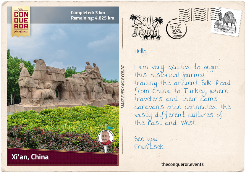
Starting in the ancient city of Chang'an (modern-day Xi'an), this journey will traverse the northern edge of the Taklamakan Desert, crossing rugged mountains, fertile lands, and oases. Along the way, I'll pass through eight modern-day countries that didn't exist in the heyday of the Silk Road, as borders and nations have changed over time. Each mile will bring me closer to my final destination: the ancient city of Antioch (modern-day Antakya), Turkey, near the sun-soaked coast of the Mediterranean.
As the eastern terminus of the Silk Road, Chang'an (modern-day Xi'an) was the imperial capital during the Western Han Dynasty (206 BCE - 9 CE). Several key trade routes passed through the city, making it a natural starting point for the Silk Road. Its strategic location near the Wei River and surrounded by fertile plains provided easy access to Central Asia and efficient transportation of goods.
While the Silk Road is often thought to have begun with the trading of silk, it was actually China's need for hardy horses for military purposes that set it in motion. In search of strong and reliable cavalry horses, the Han Dynasty looked westward to Central Asia, where the famed "Heavenly Horses" were bred. In 130 BCE, Emperor Han Wudi sent the diplomat Zhang Qian on a mission to secure these horses and establish diplomatic ties with Central Asian kingdoms. His journey is considered the starting point of the Silk Road, connecting the East and West. As a key figure in its early development, Zhang Qian's fascinating travels opened the door to centuries of trade and cultural exchange—a story I'll explore further next.
km od začátku : 0029
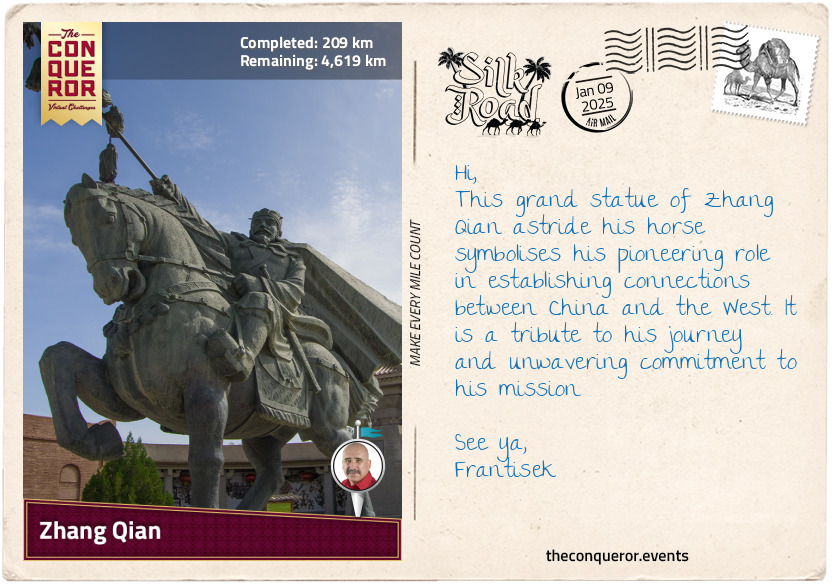
Zhang Qian
Regarded as one of the most important figures in the history of the Silk Road, Zhang Qian was a diplomat and politician in the service of Emperor Wu. At the time, two powerful empires were emerging: Rome in the West and China in the East. While China was expanding westwards, seeking to establish commercial ties with distant lands, it was regularly raided by nomadic tribes, especially the Xiongnu, who controlled Central Asia.
To deal with this threat, the Chinese decided to strengthen their military by acquiring better horses. At the time, they only had small, pony-like horses unsuitable for carrying soldiers in armour. The "heavenly horses", larger and stronger, were said to come from the distant valleys of Fergana, located beyond the Tianshan Mountains, in what is now Uzbekistan and Kyrgyzstan. These horses were perfect for battle, and the Chinese needed them to defend against raids and improve their military power. This quest would lead to one of the most important journeys in Chinese history.
Around 138 BCE, the emperor sent an expedition to find these "heavenly horses". The envoy, led by Zhang Qian, set off with 100 men, including Ganfu, a captured native Xiongnu. Travelling to the western end of the Great Wall of China, Zhang continued toward the infamous Taklamakan Desert, knowing very well that he would have to pass through Xiongnu territory. It wasn't long before he was caught and spent ten years as a prisoner. During this time, he married a Xiongnu woman and had a child, but he never wavered from his mission, one that no other Chinese dignitary was willing to undertake. By this stage, the emperor had already presumed him dead. As oversight eased, Zhang fled, and instead of returning home, he continued until he reached the court of the Yuezhi in 129 BCE.
Hoping to negotiate an alliance, Zhang remained in Yuezhi for a year. Unable to persuade the chief, he left for China, only to be captured again by the Xiongnu. With civil war breaking out and the death of the shanyu (Xiongnu leader), Zhang seized the opportunity to escape a year later. This time, he returned with his family and the loyal Ganfu, the only other person to make it back to the Han court.
Although his mission was unsuccessful, he returned with valuable information. During his time with the Xiongnu, Zhang gained extensive knowledge of the Central Asian landscape, as well as the customs and politics of the Xiongnu and other nomadic tribes. He confirmed the existence of the "heavenly horses" in Fergana and, more importantly, introduced the idea of trade with the West by sharing stories about distant empires like Persia and India. While trade routes to the West had existed for centuries, Zhang's journey paved the way for the Silk Road, opening up trade between China and the West.
km od začátku : 0346
Tianshui, China
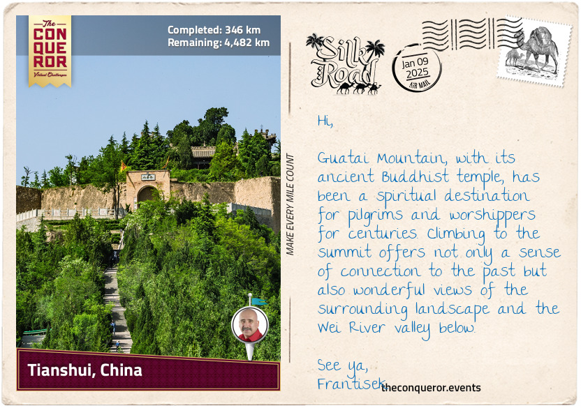
Tianshui's history stretches back over 3,000 years, starting in the early days of the Zhou dynasty, one of the longest-ruling dynasties in Chinese history, lasting more than 790 years (1046–256 BCE). This makes Tianshui one of the oldest settlements in the area.
The Zhou dynasty was known for its philosophy, agriculture, and technological advancements. However, the land was not peaceful. Nomadic invaders, skilled on horseback from the north and west, attacked the region. In addition, internal instability due to political conflict, weak leadership, and the rise of the powerful Qin state led to the dynasty's collapse.
As the Qin state grew stronger during the Warring States period (475–221 BCE), it eventually conquered all other states, paving the way for the Qin dynasty and the ascension of Qin Shi Huang as the first emperor of China, who is credited with unifying the country.
Reclaiming places like Tianshui helped the dynasty expand its lands, as evidenced by the archaeological discoveries of ancient Qin tombs in nearby Fangmatan. Two tombs were excavated in 1986. One contained ancient texts written on bamboo slips and seven maps drawn on pine wood in black ink illustrating the Jialing River systems. The other tomb contained a paper map fragment depicting topographical features such as mountains, waterways, and roads. The highlight of this map is that it was drawn on the oldest existing piece of paper, which is more than 2,000 years old.
When the Qin Dynasty was replaced by the Han Dynasty in 206 BCE, Tianshui became part of a much larger empire, leading to increased trade and exploration. Its location along the Wei River valley, which led to Xi'an, made it a crucial military stronghold and an important stop along the Silk Road for merchants, troops, and officials. Tianshui played a key role in protecting the western approach to the capital and China's central plains, making it a frequent site of conflict. As a central hub, it helped maintain communication and control across the empire, becoming vital to the Han Dynasty's administration and military operations.
km od začátku : 0386
Lanzhou, China
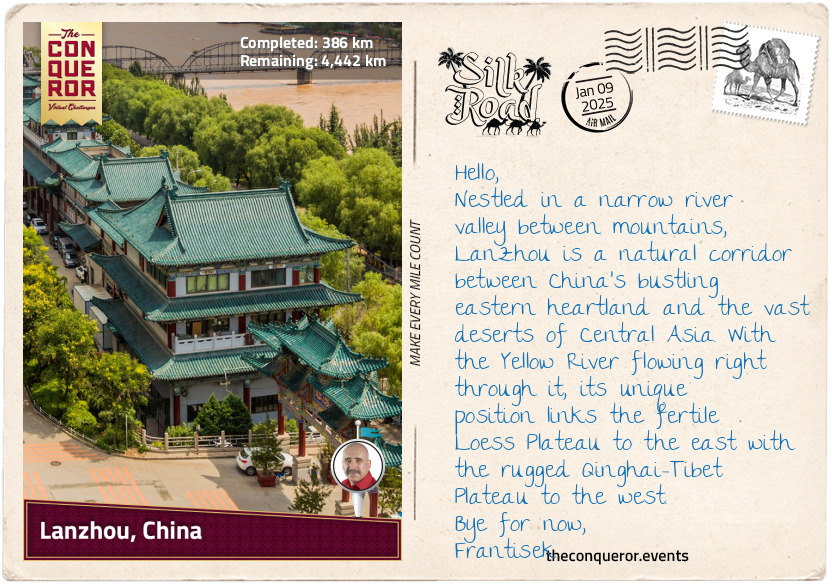
Lanzhou's history stretches back more than 15,000 years, beginning when people first settled along the upper reaches of the Yellow River. Around 5,000 years ago, the Majiayao Culture emerged, renowned for its intricately coloured pottery. Over time, Lanzhou evolved from a small settlement into a thriving administrative region.
During the Western Han period (206 BCE – 9 CE), the city was known as Jincheng, or "Gold City", because gold was found there. As a critical passage into the heart of China, Lanzhou was an important military and trade outpost. The city's walls and fortifications were strengthened to protect it from nomadic tribes like the Xiongnu, who posed a constant threat. As a key military stronghold, it helped secure the Silk Road routes and control access to China.
This was further strengthened by the strong currents of the Yellow River and the mountainous terrain surrounding the city, creating a natural protective barrier that provided an additional defensive advantage. The river was also the cornerstone of Lanzhou's prosperity. Known as China's "Mother River", the Yellow River (the second longest in China) sustained Lanzhou's communities and farmland, enabling the region to flourish. Its waters fed crops and provided a natural route for transporting goods. For travellers along the Silk Road, Lanzhou was a vital crossing point where merchants from as far away as Persia, India, and Central Asia stopped to trade goods. Silk, ceramics, and paper from China were exchanged for spices, gemstones, and textiles from the West. Among these treasures, tea became one of the most sought-after commodities.
Tea was prized for its delicate flavour and health benefits, making it a favourite among traders and nobles. Tea was often compressed into bricks or cakes to withstand the long journeys. These compact forms preserved its freshness and made it easy to transport.
The tea trade brought together a variety of cultures. For example, in Tibet, brick tea was mixed with yak butter and salt to make po cha, a strong and smoky tea. Its high-fat content provided essential energy and warmth to those travelling in cold mountainous regions. In the Middle East, tea was infused with clove, cinnamon or cardamon, crafting aromatic blends.
In Central Asia, tea was more than just a drink—it became a currency of sorts, often traded for goods or used to create bonds between people from different places. This helped shape the cultures along the Silk Road, fostering deeper connections between distant lands. Tea became more than a commodity; it was a cultural connector that brought people of different backgrounds together, whether for trade, conversation, or ritual.
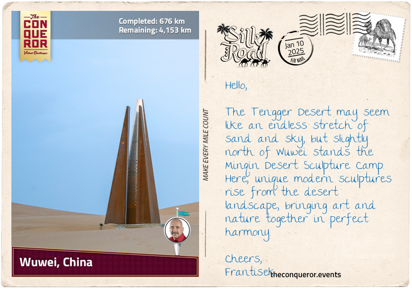
km od začátku : 0676
Wuwei, China
Wuwei, once known as Liangzhou, was the eastern end of the Hexi Corridor and played an important role in the history of the Silk Road. Settled over 5,000 years ago, the area was initially used as grazing land by the Yuezhi people during the Qin Dynasty. By the Han Dynasty, however, the Xiongnu tribe had taken control. It expelled the Yuezhi people, marking a turbulent time in the Corridor's history.
In 121 BCE, Emperor Wu of Han tasked his 20-year-old nephew, General Huo Qubing, to lead an army against the Xiongnu. He achieved a decisive victory at the Battle of Mobei and helped secure the Hexi Corridor for the Han Dynasty.
The Hexi Corridor itself is a long, narrow band of land stretching about 620mi (1,000km) through western Gansu Province. It is bordered by the imposing Qilian Mountains to the south and the arid expanse of the Tengger Desert to the north, making it an ideal route for connecting central China to the West and offering a safe passage through what would otherwise be tough terrain. Wuwei's location is particularly significant because it sits at the meeting point of three major geographical regions: the high-altitude Qinghai-Tibet Plateau, the fertile but erosion-prone Loess Plateau, and the arid Mongolian-Xinjiang Plateau. This unique convergence of landscapes shaped Wuwei's environment, contributing to its importance as a trade and cultural hub.
The Qilian Mountains were a lifeline for the region. Their snowy peaks not only created a natural protective barrier but also supplied vital water from melting snow, feeding rivers and streams, making farming and settlement possible in an otherwise dry region. Meanwhile, the Tengger Desert bounded the northern part of the corridor. Its harsh, dry conditions meant that travellers were forced to stick to the narrow strip of the Hexi Corridor, where resources were concentrated, and survival was more feasible.
Wuwei's strategic position along the Hexi Corridor made safeguarding the Han Empire's western frontier essential. By controlling this vital region, the Han Dynasty could protect trade routes, monitor military movements, and maintain stability between central China and the nomadic tribes of the West.
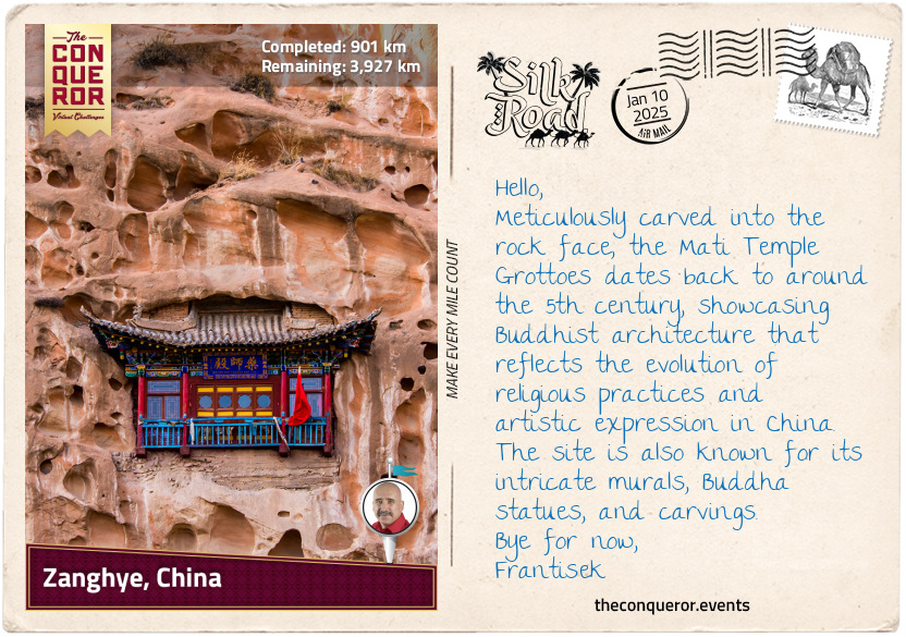
km od začátku : 0901
Zhangye, China
Located in the centre of the Hexi Corridor, Zhangye is a city surrounded by the Qilian Mountains to the south, Longshou Mountain to the north, and the Hei River to the west. The terrain is flat, fertile, and lush with forests. It is a land of contrasts where snow-capped mountains, grasslands, and deserts coexist. In the foothills of the Qilian Mountains is the Zhangye National Geopark. Inscribed as a UNESCO site, the park is famous for its strikingly colourful rock formations. The rocks, with their smooth shapes, resemble a layered cake that has been tilted—a result of tectonic shifts. Over time, wind and rain sculpted these formations into towers, pillars, and ravines, each with its own unique colour and pattern.
Zhangye once served as the capital of the Northern Liang Kingdom (4th to 5th centuries), led by the Juqu clan, whose ancestors had served under the Xiongnu tribe. The military commander Juqu Mengxun seized power through political manoeuvres, including tricking Duan Ye, the governor of the region, into killing his rival, Juqu Nancheng, the crown prince. After the assassination, Duan Ye was executed in retaliation. Mengxun declared himself Duke of Zhangye, solidifying his rule over the kingdom.
Juqu Mengxun promoted Buddhism during his time in power, even though the religion had been gradually spreading to China via the Silk Road since the 1st century. Initially, it was influenced by Taoism, but over time, Indian Buddhist texts were translated into Chinese, creating a valuable collection that spread throughout East Asia. Buddhism flourished during the Tang Dynasty (618-907), and its influence shaped art, literature, and culture during this golden period.
Despite some anti-Buddhist persecutions, Buddhism remained significant, and today, it is the largest established religion in China and practiced by more than 30% of its population. In the centre of Zhanghye, The Dafo Temple, built around the 11th century, stands as a testament to this enduring influence. The most famous feature of the temple is the Giant Buddha, one of China's largest reclining Buddha statues. Made of wood and painted in gold leaf, the statue measures 115ft (35m) long and 25ft (7.5m) wide.
In the 15th century, during the Ming Dynasty, Emperor Ying Zhong gifted more than 6,000 scriptures to the monastery. Some were copied onto Prussian blue paper using ink made from gold and silver powder, adding a layer of luxury and making them not only incredibly valuable as artifacts but also highlighting the importance of Buddhist practices and teachings in China.
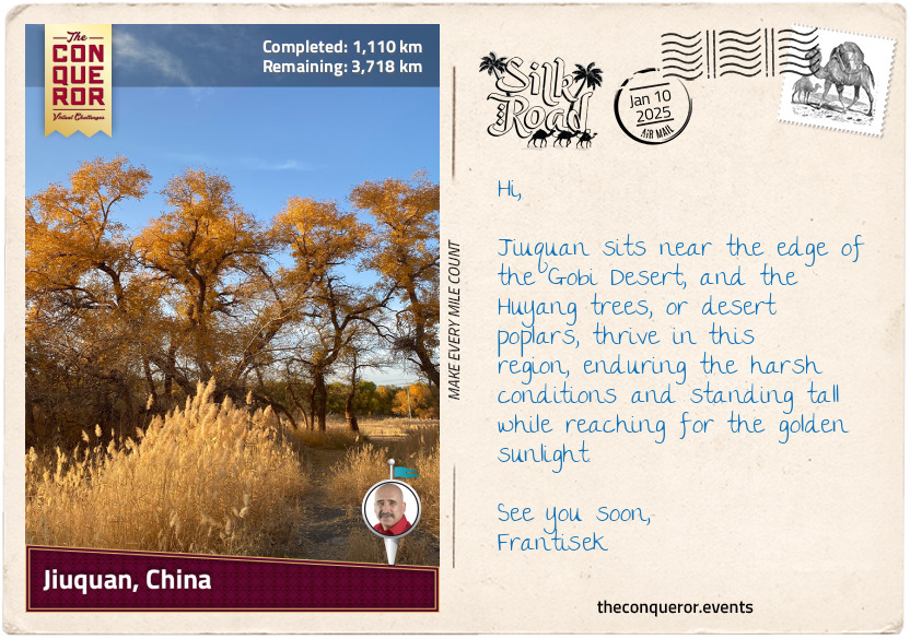
km od začátku : 1110
Jiuquan, China
Fulu, later known as Suzhou and now called Jiuquan, was founded on the edge of the Gobi Desert in 111 BCE. Nestled within the Hexi Corridor, Jiuquan served as a military outpost and a bustling hub for trade, exploration, and cultural exchange.
The city's name, meaning "Wine Spring", is said to come from a legend during the Han Dynasty when General Huo Qubing's soldiers were rewarded with wine that flowed into a nearby spring after a victorious campaign.
A key aspect of Jiuquan's prominence was its proximity to the Jade Gate (aka Yumen Pass) to the northwest. The pass was an important Silk Road checkpoint that safeguarded merchants and travellers. It was named for the coveted jade transported from Khotan, a region in modern-day Xinjiang renowned for its high-quality nephrite. Prized for its durability, smooth texture, and symbolic associations with purity and immortality, jade was used for tools, ornaments, and ceremonial objects. Its reputation as the finest jade made it a significant trade item on the Silk Road, passing through the Jade Gate on its journey to the heart of the Chinese empire.
Just to the west of the city stands Jiayu Pass, the western terminus of the Great Wall of China, a massive series of fortifications built to protect the empire's northern borders. Stretching over 13,000mi (21,000km), the Great Wall marked the northern boundary between China and the nomadic tribes. It served both as a defensive barrier and a symbol of imperial power. On this western frontier, the Great Wall and the Jade Gate, along with other nearby passes, formed a meeting point where military power and trade came together, ensuring the safety and success of the Silk Road.
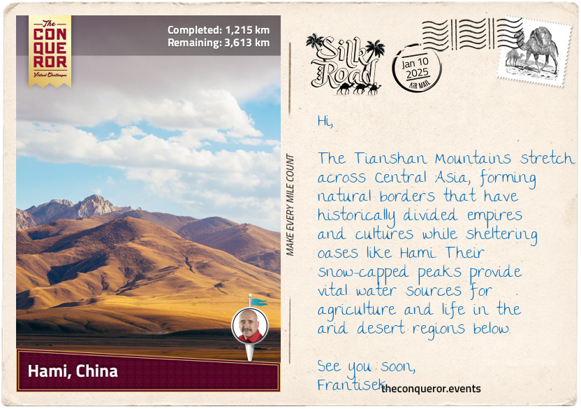
km od začátku : 1215
Hami, China
Hami, known variously as Yizhou, Kumul, and other names throughout its history, lies at the base of the Tianshan Mountains in China's Xinjiang region. Its identity has been shaped by the Han Chinese, Uyghurs (a Turkic ethnic group), and Mongols, who lived, traded, and inevitably battled over this oasis. Its strategic location made it a coveted prize, passed between empires like a ping-pong ball as they struggled to control the Silk Road's vital lifeblood. This crucial trade artery carried goods, stories, and ideas, but Hami is perhaps most legendary for its sweet and iconic melons. Cultivated since the Han Dynasty, a half-dried Hami melon was even discovered in a tomb in nearby Turpan City, dating back at least 1,500 years.
The Tianshan Mountains, with their snow-capped peaks, provide both a formidable barrier and a vital water source. Hami's ingenious farmers tapped into this resource through ancient karez systems—underground irrigation channels that carried water from distant mountains to the melon fields. These systems conserved water and prevented evaporation, essential for agriculture in the arid landscape. Thanks to this ingenuity, the Hami melon, celebrated for its high sugar content, juicy flesh, and aromatic flavour, flourished in this challenging environment.
While fresh Hami melons were difficult to transport over long distances on the Silk Road without spoiling their seeds were likely traded, spreading the fruit's cultivation far and wide—a fact reflected in their availability today in far-flung places such as the USA and Australia.
Several enduring tales highlight the Hami melon's symbolic significance in local culture. One of the most famous, The Emperor's Melon, dates to the Tang Dynasty. According to legend, a Uyghur farmer presented the emperor with a melon during a caravan visit to the capital. So impressed was the emperor by its sweetness that he declared Hami the "Land of Heavenly Melons", leading to the fruit being sent regularly to the imperial court.
Another tale, underscoring the melon's association with life and survival, recounts the story of a merchant caravan stranded in the desert, their water supplies exhausted. On the brink of collapse, they stumbled upon an oasis where locals offered them Hami melons. The melons quenched their thirst and rejuvenated their spirits, enabling them to continue their journey.
Even today, Hami melons are celebrated for their versatility and unique flavour. To honour this ancient fruit, here is a refreshing dessert recipe, perfect for summer:
Hami Melon Sorbet
Ingredients:
2 cups Hami melon, diced
1/4 cup sugar (adjust based on melon sweetness)
1 tablespoon lemon juice
1/2 cup water
Instructions:
Blend the melon, sugar, lemon juice, and water until smooth.
Strain the mixture to remove any pulp.
Chill in the refrigerator for an hour.
Pour into an ice cream maker and churn, or freeze in a shallow dish, stirring every 30 minutes until the texture resembles sorbet.
Serve garnished with mint leaves.
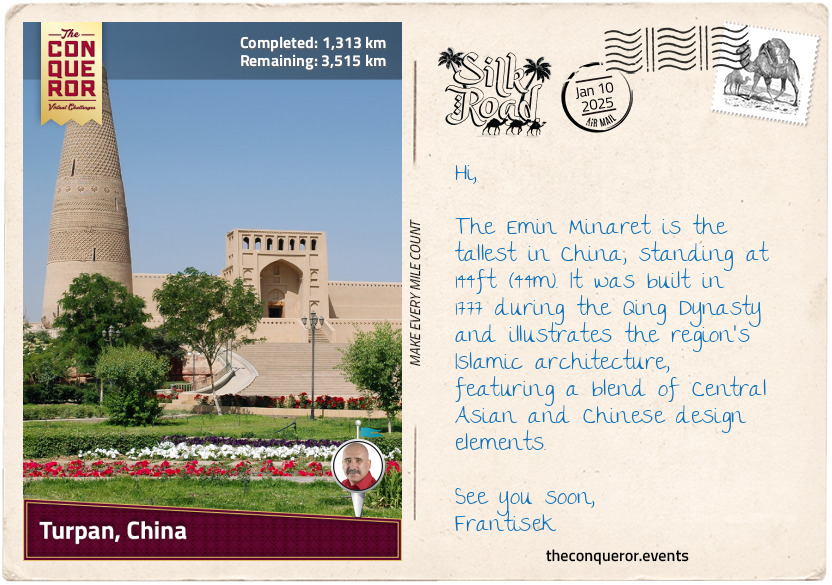
km od začátku : 1313
Turpan, China
Like Hami, Turpan is located in Xinjiang and is one of Central Asia's most ancient and historically significant oases. Its history stretches back thousands of years, with archaeological evidence pointing to early human settlements as far back as the Bronze Age. Artefacts reveal the presence of metallurgy, farming, and trade networks, which laid the foundation for Turpan's later prominence as a commercial hub, further strengthened by its strategic position along the northern route of the Silk Road.
Also, like Hami, Turpan's long-term control alternated between Chinese dynasties, local rulers, and other Central Asian powers, such as the Uyghurs (Turks) and the Xiongnu (nomads). Regardless of the changing powers, however, Turpan flourished and absorbed the cultural, religious, and technological influences left behind by each ruling group, including the innovative underground irrigation system known as the karez. This system, combined with the region's arid climate, supported Turpan's tradition of grape cultivation since the Han Dynasty, especially seedless white grapes, along with red and black grapes harvested in the fall.
As a bustling crossroads, many goods were traded, but silk was one of the most highly sought-after products. First produced in China thousands of years ago, silk is made from the silkworm’s cocoon, which is fed on mulberry leaves. According to Chinese legend, Empress Leizu (circa 27th century BCE) discovered silk by accident. The story goes that while she was sitting under a mulberry tree, a silkworm cocoon fell into her tea. As she tried to retrieve it, the cocoon began to unravel into long, delicate threads. Intrigued by the fine threads, she is said to have figured out how to unwind them carefully and weave them into fabric. Although the details of this story are mythical, the empress is still credited with introducing sericulture, the practice of raising silkworms to produce silk.
Silk became highly valuable due to its lightweight, smooth texture, natural sheen, and vibrant colours. The production process was labour-intensive, and while the fabric had a delicate feel, it was surprisingly strong and durable. Silk was often associated with royalty and nobility, symbolising wealth and status, and its rarity outside of China made it a desirable, exclusive luxury fabric for garments and tapestries.
km od začátku : 1448
Aksu, China
Aksu, located at the western edge of Xinjiang, shows a clear blend of Chinese and Central Asian influences. As we move further into the region, where the Uyghur population makes up more than 70% of the residents, a clear shift from Han Chinese culture becomes evident. The Uyghurs, a Turkic ethnic group with deep historical roots in the region, have traditionally inhabited a series of oases scattered across the Taklamakan Desert. These oases were sometimes independent states but, at other times, were controlled by various powers, such as China, the Mongols, and the Tibetans. Over time, the Uyghurs gradually embraced Islam starting in the 10th century, with many of their practices deeply rooted in Islamic traditions. This has shaped a distinct blend of Uyghur culture, marking a cultural transition as we move further west.
The vast Taklamakan Desert forms the southern border of Aksu, bounded by mountains on three sides and the Gobi Desert to the east. Stretching 620mi (1,000km) long and 250mi (400km) wide, with dunes rising to 300ft (91m), it is one of the largest and driest deserts in the world. The climate varies widely, with summer temperatures soaring to 114°F (45.6°C), while winter temperatures can plunge below -4°F (-20°C). The desert receives less than an inch (2.5 cm) of rainfall per year, and over the last 1,000 years, it has expanded by a further 62mi (100km) to the southwest.
While the Taklamakan conjures images of dryness and desolation, China's longest inland river, the Tarim River (821mi/1,321km), flows right through it, providing crucial support to the ecosystem. This includes the 60-million-year-old native poplar forests, which continue to thrive despite the harsh conditions, although for a time, they faced environmental challenges due to human activities and reduced water flow.
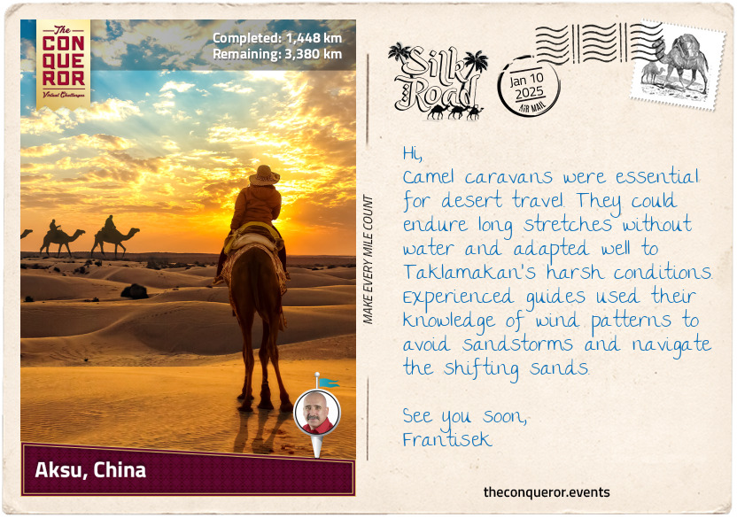
Two branches of the ancient Silk Road once skirted the Taklamakan Desert—one to the north and one to the south. Travelling around this unforgiving expanse was incredibly dangerous, as merchants and caravans faced extreme temperatures, relentless sandstorms, and constantly shifting dunes that could erase paths without warning. The scarcity of water increased the risks, making oases essential for survival. Settlements near reliable water sources became crucial waypoints, offering shelter, supplies, and guidance to weary travellers. Local guides were especially valuable with their deep knowledge of the desert's shifting landscape and how to navigate the treacherous terrain.
km od začátku : 1558
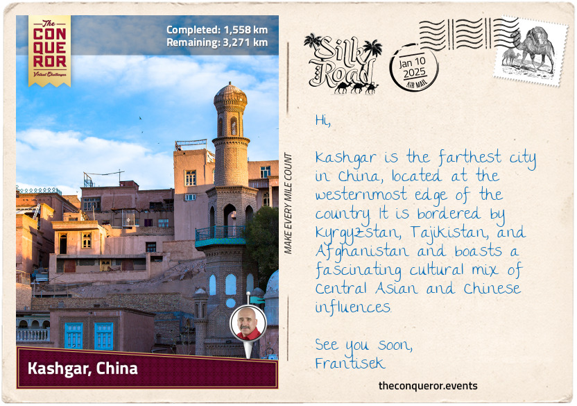
Kashgar, China
Nestled at the western edge of the Tarim Basin, Kashgar was an isolated yet pivotal oasis town where the Taklamakan Desert met the Pamir Mountains. It was an important stop for caravans travelling to trade with Central Asia, India, Pakistan, and ancient Persia. Because it was at the crossroads of the northern and southern Silk Road routes, Kashgar became a major centre for trading spices, especially those from India, like black pepper, cardamom, and saffron.
India was key in transporting these spices across its subcontinent or along the Indus River, connecting to trade routes that reached Central Asia. Southeast Asia, especially the islands of modern-day Indonesia, also sent spices like cloves, nutmeg, and cinnamon. These spices would travel by sea to India before continuing overland through Persia and other trade centres to Kashgar. The Middle East also helped spread spices, blending goods from the Indian Ocean region with local products like frankincense (a fragrance derived from the Boswellia tree, used in incense, perfumes, and medicine) before sending them to markets across the continent.
Imagine how, in this bustling oasis, mixing flavourful spices with different cooking techniques could create a fusion of dishes, aromas, and delightful tastes, each reflecting the distinct culinary traditions of Chinese, Persian, Indian, or Central Asian cultures. As these spices travelled far and wide, the same basic dish, though prepared in different regions, would vary based on the local ingredients available. These shared meals became wonderful opportunities to exchange cultures through cuisine.
While Kashgar is in the Xinjiang region of China, its food is nothing like traditional Chinese cuisine. Instead, it's shaped by the Uyghur people, the city's dominant cultural group, with dishes influenced by hearty lamb, handmade noodles, spices like cumin and chilli, flatbreads, and sweets such as dried fruits, nougats, and pastries. A meal might begin with comforting bowls of lamb and vegetable soup paired with fresh naan bread, followed by smoky, spicy kebabs. To finish, a simple dessert like zongzi—a Uyghur twist on classic Chinese sticky rice with sweet red dates, topped with yogurt curd and sugar—is complemented by fragrant cups of tea.
km od začátku : 1601
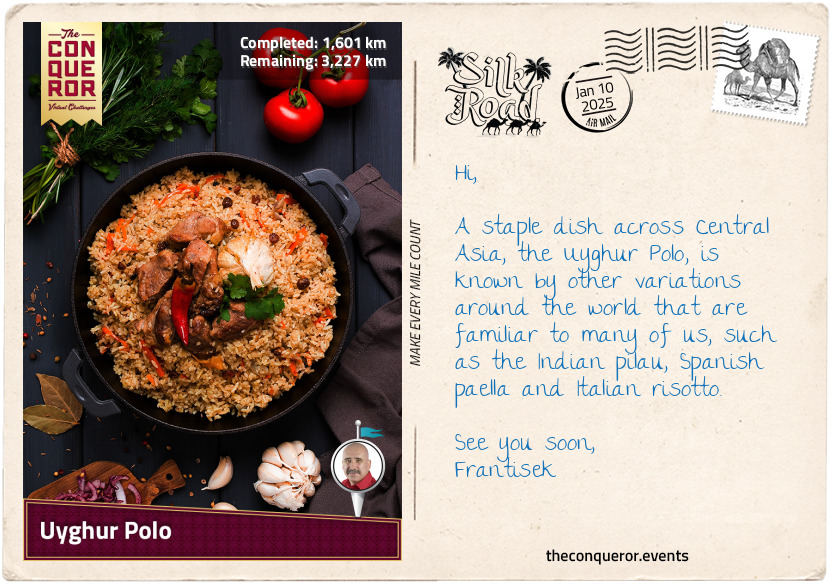
Uyghur Polo
Polo is a Uyghur-style pilaf made by frying lamb with onions and thinly sliced carrots in oil. Then, rice and water are added and steamed, allowing the rice to soak up all the aromatic juices. Cumin, coriander, and sometimes a hint of cinnamon are added to infuse the meat and rice with rich, savoury flavours. To balance the richness, raisins and dried apricots are often included and the dish is then served with fresh bread and yoghurt.
Notes
Use a heavy-bottomed, deep pan with a lid to help cook the ingredients evenly.
Use lamb shank for its tenderness and juiciness when slowly cooked. Beef and chicken can be used as alternatives if you don't like lamb or kidney beans for a vegetarian option.
INGREDIENTS (Serves 4)
1 lb (500 g) lamb shank – chop into 5-6 chunks
1 lb (500 g) carrots – peel and cut into matchsticks (Julienne-style)
½ cup olive oil
1 large red onion – peel, halve and slice
½ cup raisins (optional)
2 cups rice – rinse until water is clear to remove the starch that makes it stick
2-3 cups water (enough to cover the ingredients in the pan)
1.5 teaspoons salt
½ teaspoon cumin
1 teaspoon sugar
INSTRUCTIONS
Heat the oil on high, add the meat and brown on all sides.
Add onions, cumin, salt, carrots, and sugar. Mix and cook for about 10 minutes.
Add the water, bring it to a boil, then lower to a simmer. Adjust flavour as needed.
Drain the rice and add to the pan. Spread it evenly on top of the liquid (do not mix).
Sprinkle the raisins on top.
Poke a few holes in the rice layer (it simmers easier), then cover.
Cook on low for about 35 minutes (check at the end that it is fully cooked).
Mix all the ingredients. Tear the big chunks of lamb into bite-sized pieces and place them back on the polo.
Video tutorial: https://youtu.be/a46wspZtOkI - Have fun with the cooking and enjoy your meal.
km od začátku : 1645
Osh, Kyrgyzstan
Leaving China behind, I entered Kyrgyzstan, a country in the heart of Central Asia. During the Silk Road era, the land was ruled by Turkic nomads for about seven centuries until the Mongols conquered it in the 13th century. Kyrgyzstan is a completely landlocked country and among the furthest from the nearest ocean. It borders Kazakhstan up north, Uzbekistan to the west, Tajikistan in the south, and China to the east.
The landscape here is wild and dramatic, with the towering Tianshan Mountain in the northeast and the rugged Pamir-Alay Mountain in the south. Nestled between these ranges is the lush and fertile Fergana Valley, a major agricultural hub for centuries, known for its cotton fields. While the mountains have historically isolated Kyrgyzstan, they also made it an ideal route for merchants navigating the Silk Road.
Traveling through Kyrgyzstan inevitably led to Osh, the country's second-largest city with a history of over 3,000 years. One of Osh's most iconic features is its vibrant marketplace, which has been operating almost continuously in the same location for the past 2,000 years. Over the centuries, merchants from all over would gather in the bazaar to exchange goods, with silk, spices, and ceramics heading west while gold, glass, and woolen goods made their way east.
Aside from trading goods, merchants and travellers would stop at bustling markets like the one in Osh to find street food or small eateries. Here, they would find a variety of foods, such as dried fruits, nuts, breads, kebabs, and flatbreads, as well as local delicacies like pilaf, dumplings, and falafel. Lagman, for instance, is a wonderfully hearty Central Asian dish believed to have originated from the Chinese "lo mein", meaning stirred noodles. Over the centuries, it has evolved and been influenced by various cultures, particularly Uyghur cuisine. Lagman consists of hand-pulled noodles in a rich, savoury broth with meat, bell peppers, tomato paste, celery, cabbage, and spices.
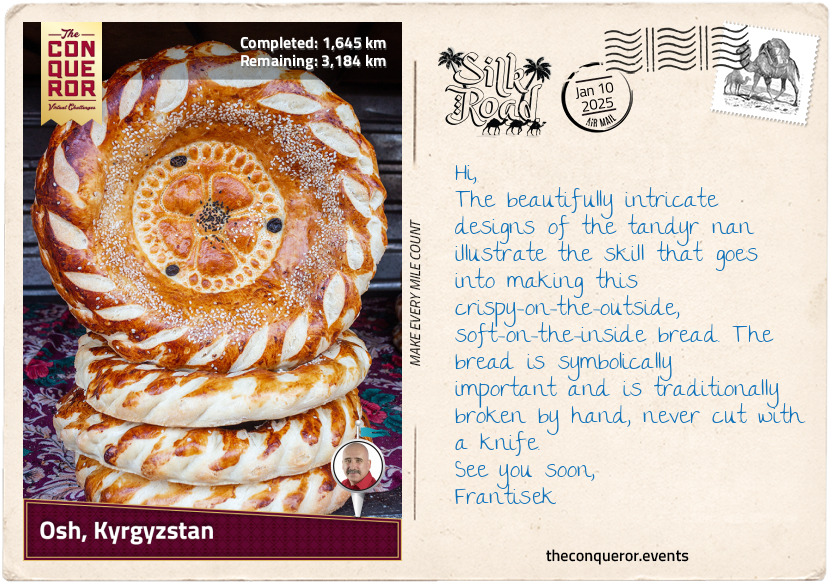
In Osh, a delicious accompaniment to the broth is a type of decorated bread known as "tandyr nan", named for how it's baked in a tandoor oven or "lepyoshka". Freshly prepared each day, this bread is typically round, with a soft, fluffy interior and a crisp golden-brown crust. What makes it stand out is the decorative stamp pressed into the top of the dough before baking, often featuring geometric patterns or floral designs. These designs sometimes carry symbolic meanings related to prosperity, fertility, or blessings. They are commonly offered during celebrations like weddings or festivals.
km od začátku : 1698
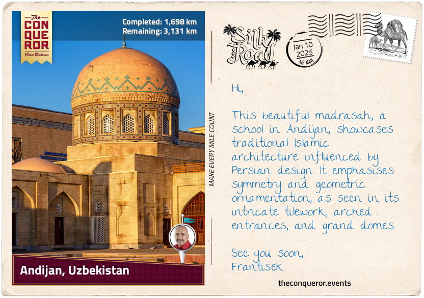
Andijan, Uzbekistan
Uzbekistan marks the third modern-day country on this journey, where caravans once passed through Andijan, Kokand, Samarkand, and Bukhara along the ancient Silk Road route, leaving behind some of the most incredible Islamic architecture. The country is bordered by Turkmenistan, Kazakhstan, Tajikistan, and Kyrgyzstan, making it one of only two double landlocked countries in the world—meaning it is surrounded entirely by other landlocked nations. The other such country is Liechtenstein in Europe.
Uzbekistan has a varied landscape, with large deserts like the Kyzylkum Desert in the north, the second largest in Central Asia, mountains in the east that are prone to earthquakes, and the fertile Fergana Valley, which is watered by the Syr Darya river.
The city of Andijan sits within the fertile Fergana Valley and has long been historically linked to agriculture. The region is known for cultivating cotton, silk cocoons, grains, and fruit trees such as apricots, peaches, and grapes. Its rich soil and irrigation systems, fed by rivers from surrounding mountains, made it an ideal location for farming. Archaeological evidence shows that Andijan is over 2,500 years old, making it one of the oldest cities in Central Asia.
The region around Andijan was controlled by many powerful empires, beginning with the Persian Empire, which ruled in the early centuries BCE, until Alexander the Great's conquest in the 3rd century BCE and the rise of the Greco-Bactrian Kingdom, when Greek culture spread across Central Asia. Over the centuries, further empires like the Kushans and Sassanids took control until the city became part of the Arab Caliphate during the Islamic conquest in the 8th century. By the 10th century, the Samanid Empire had taken control, and the area was transformed into a centre of Islamic culture.
A notable figure from Andijan is Zahīr ud-Dīn Muhammad Bābur. Born in 1483, toward the end of the overland Silk Road era, Bābur was a descendant of Timur (14th-century founder of the Timurind Empire) on his father's side and Genghis Khan (13th-century founder of the Mongol Empire) on his mother's side. Babur was a statesman, poet, and author renowned for his memoir, the Baburnama, which recounts his exploits as a minor ruler of Fergana who twice attempted to capture Samarkand but failed. Setting his sights further afield, Babur conquered Kabul in present-day Afghanistan and later invaded northwestern India. He founded the Mughal Empire there, which his descendants expanded over 300 years of rule. They became famous for their prolific constructions and the development of Mughal architecture, such as the Taj Mahal in Agra and the Red Fort in Delhi.
km od začátku : 1822
Kokand, Uzbekistan
Located at the western end of the Fergana Valley, Kokand, along with nearby Margilan and Rishtan, forms a trifecta of artisan cities, each steeped in centuries-old traditions of craftsmanship, often passed down through generations within families. Kokand’s earliest mention, under the ancient name of Khavakand, dates back to the 10th century. The city didn't last long, as the Mongols destroyed it in the 13th century. After rebuilding, it took another 600 years for Kokand to regain its footing, eventually becoming the capital of the Kokand Khanate (kingdom) in the 18th century and thriving under its rule.
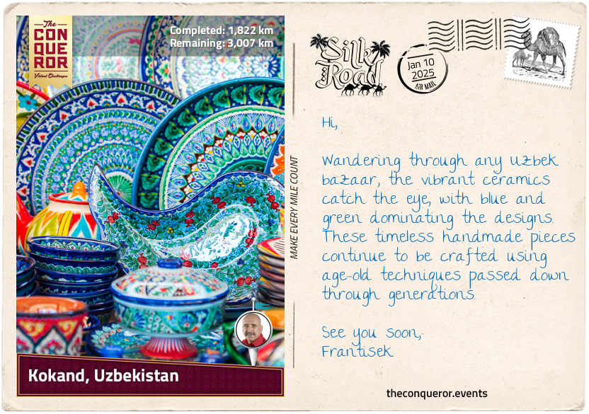
Kokand has long been a centre for wood carving, where artisans chisel intricate designs into doors and furniture. The city is also renowned for its ceramics, particularly its decorative tiles in vivid shades of green and blue—two colours that hold significance in Uzbek culture. Green symbolises nature and the flourishing of plants, while blue is associated with the sky and represents peace.
Southeast of Kokand is Rishtan, the pottery capital of the Fergana Valley. Artisans use the region's red clay to create bowls, plates, and tiles, often painting floral and geometric designs with distinctive blue and green glazes. Purple, too, makes an appearance in the pottery, representing the festive spring days and the blossoming of fruit trees.
Further east is Margilan, famous for its silk production. The leaves of mulberry trees feed the silkworms, which produce threads dyed and woven into ikat fabrics. The term ikat originates from the Indonesian word "ikat", meaning "to tie" or "to bind". This refers to tie-dyeing the threads before weaving them, creating intricate patterns in the final textile.
These crafts, which have been developing for over a millennium, have made Kokand, Rishtan, and Margilan the renowned artisanal centres they are today. The vibrant goods crafted in these cities would have drawn attention in the bustling markets of the Silk Road. As the merchants traded and shared these exquisite textiles, ceramics, and wood carvings, the crafts spread far and wide, helping the Fergana Valley solidify its reputation as a centre for artistry and craftsmanship.
km od začátku : .jpg
Samarkand, Uzbekistan
The legendary city of Samarkand has, for more than two millennia, been a key crossroad for the Silk Road. Sitting on the southern banks of the Zeravshan River in northeastern Uzbekistan, its history traces back to 1,500 BCE. Initially governed by local tribes, the region was later ruled by the Persian Empire until Alexander the Great's conquest.
By the 6th century BCE, Samarkand became home to the Sogdians, ancient Iranians known for their trading skills. It was a melting pot of religions, influenced by Zoroastrianism (Persian faith), Christianity, Buddhism, Hinduism, and Manichaeism (a dualistic religion).
Despite suffering devastation from Genghis Khan's Mongol armies in 1220, Samarkand experienced a remarkable revival in the 14th century under Timur (aka Tamerlane), founder of the Timurid Empire. Timur made Samarkand his capital and turned it into a major cultural and scientific centre.
Many of the city's landmarks are representative of the Timur Dynasty, as they showcase the grandeur and architecture of the era. One of the most iconic examples is the Shah-i-Zinda mausoleum complex, a collection of tombs and mosques dating from the mid-14th to the 16th century. The complex is the final resting place of many of Timur's relatives and Qusam ibn Abbas, a cousin of Muhammad, the founder of Islam. Qusam ibn Abbas is believed to have come to Samarkand to teach Islam and is revered as a martyr, with his tomb serving as a pilgrimage site for Muslims.
Another architectural masterpiece is the Bibi Khanum Mosque, built by Timur to honour his wife. Once one of the grandest mosques in the Islamic world, it was constructed with materials transported by 95 elephants and designed by artisans from Persia and India. The mosque features towering domes, beautifully detailed facades, and extensive use of blue and turquoise tiles. However, the mosque has suffered significant damage due to its hasty constructions and earthquakes over the centuries. Restoration efforts are ongoing to help preserve its stunning tile work.
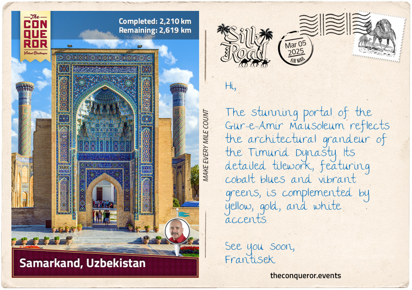
Perhaps the most historically significant landmark is the Gur-e-Amir Mausoleum, whose name means "Tomb of the King" because it is the burial place of Timur. The mausoleum has an octahedral structure crowned with an azure dome decorated with rosettes and fluting. Its walls are decorated in geometric patterns using blue, white, and terracotta tiles. Inside, the mausoleum is richly embellished with onyx panels, marble stalactite cornices, painted plaster and gilded papier-mâché ornaments. Timur's grave is marked by a solid block of dark green jade, surrounded by the tombstones of his sons, grandsons, and spiritual teacher.
km od začátku : 2484
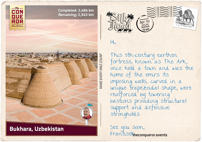
Bukhara, Uzbekistan
Bukhara is located in central Uzbekistan, on the western edge of the Kyzylkum Desert and southwest of the Amu Darya River. The area is mostly flat and arid, with sandy and gravel plains. The landscape around Bukhara is dry and semi-desert, with few hills, making it a typical desert oasis.
As a key city on the Silk Road, Bukhara began as part of the Sogdian (Iranian) civilisation, later controlled by nomadic tribes. In the 8th century, the Islamic conquest brought it into the Muslim world. Its greatest period came under the Samanid Dynasty in the 9th and 10th centuries, when it became the kingdom's capital and a centre of Persian art, science, and literature. Notable landmarks from this period include the Ismail Samani Mausoleum, where the founder of the Samanid Dynasty, Ismail Samani, is buried, and the Bolo Haouz Mosque, which still stands today.
Afterward, Bukhara was ruled by a Turkic dynasty, followed by a Persianate state, before being overthrown in the 13th century by the Mongols. Genghis Khan, the warrior-ruler, decimated many cities in his path, and Bukhara was no exception. However, when he saw the Kalyan Minaret, a stunning 150ft (46m) tower used to summon Muslims to prayer, he spared it from destruction. As a result, this nearly 900-year-old minaret survived intact and is now a prominent feature of Bukhara's UNESCO designation as one of Central Asia's best-preserved medieval cities.
Renowned for its textile industry, Bukhara traded Karakul lambs' fleeces, silk, cotton, leather, clothing, gold embroidery, and metalwork. Among these, carpet weaving was a significant craft, making Bukhara famous for its quality and designs.
Carpet weaving has been a tradition in the region for over a thousand years, and its fine craftsmanship is well-known worldwide. They are traditionally made from wool and dyed using natural vegetable dyes, giving them rich, long-lasting colours. Inspired by Persian and Turkmen designs, antique Bukhara carpets are intensely red with geometric patterns framed by a repeating border. These carpets' soft feel, thickness and almost silky appearance result from high-quality fibres. The most common motif is a gul, which is a medallion-like design element that is often octagonal.
The technology behind Bukhara's carpet weaving has remained largely unchanged for millennia. The quality and value of a handwoven carpet are determined by the materials used, such as silk, wool, or synthetics, and the density of knots per square centimetre. The more knots a carpet has, the denser and more durable it becomes, but also more time-consuming to make, thus increasing its value. The level of design intricacy, the number of colours, and the size of the carpet further influence its worth.
km od začátku : 2636
Merv, Turkmenistan
Moving onto the fourth modern-day country on the Silk Road, Turkmenistan is a land of contrasts. Bordered by Kazakhstan, Uzbekistan, Afghanistan, Iran, and the Caspian Sea, it boasts vast deserts like the Karakum, dramatic mountains such as the Köpetdag, Paropamisus and the Balkan ranges, and fertile oases. With ancient cities such as Merv and Ashgabat (the current capital) as central hubs on the Silk Road, Turkmenistan was shaped by Persian, Arab and Central Asian influences.
Merv, located near modern-day Mary in Turkmenistan, was a prominent city on the Silk Road with a history from the 3rd millennium BCE to the 18th century CE. It thrived under various empires, including the Achaemenids, Seljuks, and Timurids. At its peak in the 12th and 13th centuries, it was one of the world's largest cities. Devastated by the Mongols in 1221 and ultimately destroyed in the 18th century, its ruins are now a UNESCO World Heritage Site.
The Seljuk Empire, of Turkic origin, ruled over Central Asia and the Middle East in the 11th century and, at its peak, made Merv its capital. The Seljuks played a significant role in establishing Merv as a centre of Islamic scholarship. Known for their patronage of learning and intellectual pursuits, they helped the city thrive as a hub of education. The empire's vizier, Nizam ul-Mulk, a scholar, jurist, and political philosopher, established numerous educational institutions across the realm, offering theology, literature, and scientific studies.
Scholars like Omar Khayyam also contributed to Merv's intellectual legacy. Known as a polymath, Omar, of Persian origins, made significant advancements in mathematics, astronomy, philosophy, and poetry. In algebra, he developed a systematic method for solving cubic equations, while in astronomy, he helped revise the Persian calendar to near-perfect accuracy. As a philosopher and poet, Omar's work crossed borders, influencing and fostering the exchange of ideas among those who passed through Merv.
Merv's influence extended beyond its scholars, connecting with the broader Islamic world. Figures like Al-Biruni, from nearby modern-day Uzbekistan, contributed to this exchange through their works. A renowned polymath, Al-Biruni was well-versed in multiple languages, including Persian, Arabic, Sanskrit, Greek, Hebrew, and Syriac. His research in astronomy, mathematics, and geography would have reached Merv through texts and academic discussions, enriching the city's scholarly life. This network of knowledge established Merv as a hub for intellectual exchange.
km od začátku : 2821
Ashgabat, Turkmenistan
The Akhal-Teke horse is one of the world's oldest and most distinctive breeds, with a history that stretches back over 3,000 years. Originating in the deserts of Central Asia, particularly Turkmenistan, the breed is highly revered in its homeland, where it is considered a national treasure. Turkmenistan even dedicates a national holiday to horses. Thought to be a direct descendant of the now-extinct Turkoman horse, the Akhal-Teke was prized for its endurance, agility, and beauty, and played a significant role in the lives of ancient nomadic tribes who relied on it for transportation, warfare, and ceremonies.
What sets the Akhal-Teke apart from other breeds is its striking metallic coat, which appears to shimmer in the sunlight, earning it the nickname "Golden Horse". This shimmering effect is due to the unique structure of their hair, which reflects light and gives the appearance of a glowing coat. Known for exceptional stamina and resilience, Akhal-Tekes could endure harsh desert climates, surviving on limited food and water. It made them invaluable for long-distance travel along the Silk Road, where they carried goods and diplomats across arid and mountainous terrain. Their agility and speed also made them excellent cavalry horses, providing warriors a tactical advantage in battle.
Their loyalty is unparalleled, often described as forming a deep one-person connection with their owner. Their bond with handlers is often deep and unwavering, with horses displaying an intuitive understanding of their owners' commands.
Physically, the Akhal-Teke is a medium-sized horse, standing between 14 and 16 hands high (56-64in / 147-163cm). They are known for their slender and athletic build, narrow, expressive head and almond-shaped eyes. Their coats come in various colours, from reddish-brown, black, grey, and chestnut to palomino, cremello and perlino (shades resulting from genetic dilution). While some may have minimal white markings, their sleek, shimmering coats remain the focal point.
To illustrate the endurance of these horses, in 1935, a team of 28 Turkmen on Akhal-Teke horses set out on an extraordinary journey from Turkmenistan's capital, Ashgabat. They rode across hostile and barren landscapes through Uzbekistan and Kazakhstan, covering an astonishing 2,700mi (4,300km) to reach Moscow's Red Square in Russia. Nearly driven to extinction in the early 20th century, the breed is relatively rare, with an estimated population of 3,000 to 5,000 worldwide.
km od začátku : 2969
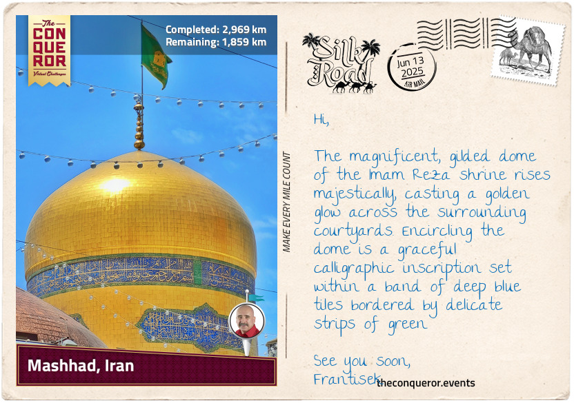
Mashhad, Iran
Mashhad lies in the Kashaf River valley, flanked by the Binalud and Hezar Masjed Mountains, in the farthest reaches of northeastern Iran. It marks the fifth country on this journey. Initially a small village overshadowed by the nearby city of Ṭūs, it gained prominence for its shrine, Imam Reza, where the religious leader Imam Ali al-Rida and the Abbasid caliph Harun al-Rashid (both 8th–9th century) are buried. Over time, Mashhad became an important pilgrimage site, a significance that endures to this day as Iran's holiest city.
One of the most renowned explorers to visit Mashhad was Ibn Battuta, a Moroccan traveller and scholar of the 14th century. By pursuing religious knowledge and adventure, he journeyed through much of the Islamic world, including Persia. His extensive travels spanned 29 years, covering what is now the equivalent of 44 modern countries and 75,000mi (120,000km) across much of continental Asia (excluding Siberia and the Russian region) and parts of Africa. He documented his journeys in the Rihla, a travelogue providing detailed accounts of the places and cultures he encountered.
Ibn Battuta began his travels alone, riding a donkey on a pilgrimage to Mecca. Along the way, he faced many threats from bandits and narrowly escaped execution. He eventually joined caravans of pilgrims and traders for safety. During his pilgrimage, he visited Mashhad in 1333. He described the town as large, with abundant fruit trees, streams, and mills. He was particularly impressed by the majestic Imam Reza mausoleum. It is notable for its gilded dome and stunning Persian-Islamic tile work featuring geometric patterns, floral motifs, and calligraphic inscriptions.
The city is also closely associated with Ferdowsi (Abu'l-Qâsem Ferdowsi Tusi), a 10th-century Persian poet from nearby Ṭūs. Ferdowsi is best known for his epic poem, the Shahnameh (The Book of Kings), which chronicles Persian history and mythology in 50,000 rhyming couplets. This monumental work, one of the longest poems ever written by a single author, took him 33 years to complete.
km od začátku : 3380
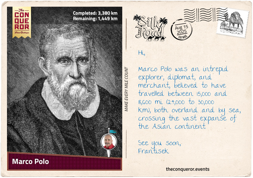
Marco Polo
Marco Polo is one of the most celebrated explorers of the Middle Ages, having travelled from Europe along the Silk Road to the court of Kublai Khan, the Mongol emperor of China and Genghis Khan's grandson. He was born in 1254 in the Venetian Republic, a maritime state centred around Venice. In 1271, Marco, then 17, along with his father and uncle, both experienced merchants, set out on an arduous overland journey to the Far East that would last 24 years.
Departing Venice, the Polos travelled down the Adriatic Sea, around Greece, and made their first stop in the port city of Acre. They spent a few months there before heading to Jerusalem to meet the newly appointed Pope, who entrusted them with letters for Kublai Khan, inviting him to send emissaries to Rome, likely to establish diplomatic relations.
From there, they crossed the Middle East, heading northeast through Persia, passing through Tabriz, and then south to Baghdad before reaching the Strait of Hormuz on the Persian Gulf, where they planned to sail to China. Searching for a ship for their journey, they abandoned the idea when they concluded none of the vessels were seaworthy, opting to continue overland.
Their path took them through the heart of Central Asia, travelling through Khorasan and Balkh before stopping in Badakhshān for about a year to allow Marco to recuperate from an illness he contracted. Moving on, the Polos ventured into the Pamir Mountains, a rugged and remote region—often called the "Roof of the World". From the mountains, they descended to the vast and arid expanse of the Gobi Desert, enduring its challenges and, at times, facing food shortages. In 1275, after four years of travel, they arrived in Shangdu (Xanadu), the summer capital of Kublai Khan's empire.
The Polos spent several years in the emperor's winter residence in Khanbaliq (modern-day Beijing). Marco swiftly found himself in the khan's service, travelling extensively across China, Myanmar (Burma), and India as a foreign diplomat. Versed in several languages, Marco's adaptability allowed him to access regions and cultures few Europeans had seen before.
After 17 years at Kublai Khan's court, the Polos began their three-year journey back to Venice, this time by sea through the Persian Gulf while escorting a Mongol princess to Persia for a political marriage. The two-year sea journey was difficult, with many passengers dying from illnesses such as scurvy and cholera, as well as encountering pirates and hostile natives.
Once back on land, they moved north to Tabriz, where they boarded another ship over the Black Sea to Constantinople and across the Mediterranean, finally arriving in Venice in 1295. Marco's return came with new challenges. Venice and Genoa were at war, and in 1298, Marco was captured by the Genoese during a naval battle and imprisoned.
In prison, he met Rustichello de Pisa, a writer who helped transcribe Marco's stories of his journeys, which would later be compiled into The Travels of Marco Polo. A year later, Marco was released and returned home. While his book sparked Europe's imagination, some doubted its accuracy. Nevertheless, it strongly influenced future explorers and helped shape how Europeans viewed Asia.
km od začátku : 3888
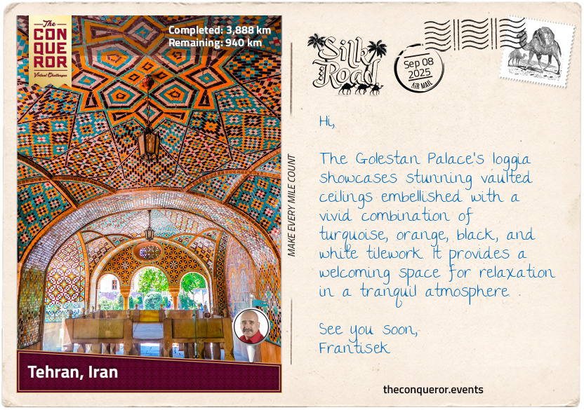
Tehran, Iran
Before Tehran became the bustling capital of Iran in the late 18th century, the area was part of a much older historical landscape, deeply intertwined with the Silk Road. The southeast region where Tehran sits today was home to the ancient city of Rhages (modern-day Ray). It was an important city through various Persian empires for several centuries, lasting from the Achaemenid Empire (6th–4th century BCE) to the Sassanian period (3rd–7th century CE).
However, after being conquered by Muslim empires in the 7th century, Ray became part of the Islamic world and maintained its importance for the next six centuries until the devastating Mongol invasion in the 13th century, which led to its near destruction. Following this, the city was abandoned, and its inhabitants moved to Tehran, which began to grow in prominence. As a result, Ray's influence steadily declined while Tehran expanded and eventually absorbed it within its boundaries.
One of the last remaining landmarks from Ray's once-glorious past is the Toghrol Tower, a 12th-century monument standing 66ft (20m) tall. Constructed from brick, the tower has a polygonal design with 24 angles, which is believed to provide stability during earthquakes, although its conical dome has long toppled after a seismic event. Traditionally believed to be the tomb of Tughril Beg, the founder of the Seljuk Empire, the exact identity of the buried person remains a subject of debate among historians. It is also said that the tower guided Silk Road travellers during foggy nights by lighting a fire, much like a lighthouse, to help them navigate their way to Ray.
A notable figure in Ray's history is Abū Bakr al-Rāzī, a Persian physician and philosopher, often regarded as the father of paediatrics and an influential figure in obstetrics and ophthalmology. Born in the city in the 9th century, he significantly contributed to medicine. He was the first to distinguish smallpox from measles and propose effective treatments for smallpox. His discoveries in medicine and his work in logic and astronomy were recorded in over 200 manuscripts, many of which were later translated. His 23-volume medical textbook al-Kitab al-Hawi (Comprehensive Book on Medicine) was incorporated into the curriculum at Western universities.
Ray's decline and abandonment opened the door to Tehran's emergence, which benefited from its location on fertile plains. Tehran remained a small village until the Qajar ruler, Agha Mohammad Khan, appointed it the capital in 1786, ushering in a new modern era.