Contained within the South Downs National Park is the 100mi (161km) bridleway known as the South Downs Way (the Way). Accessible to walkers, cyclists, and horse riders, the bridleway was first opened in 1972 and became the fifth national trail in the UK. Initially, it ran for about 80mi (128km) from Buriton to Beachy Head. Fifteen years later, it was extended, starting in Winchester, where the national park’s boundary began, to Eastbourne, stretching across Southern England.
The trail follows the chalk escarpment of the South Downs, with most of the route passing through the open countryside along the top of the ridges. It crosses the counties of Hampshire, West Sussex, and East Sussex. The Way can be tackled in either a westbound or eastbound direction. In a handful of places the bridleway splits for a short distance until it merges back with the footpath. It is waymarked with a white acorn symbol, the UK’s National Trails logo, and colour coordinated with arrows. When the path diverges, the yellow arrow designates the footpath and the blue arrow the bridleway.
Between the hills are expansive verdant valleys with major rivers running through them. The Way climbs up and down these valleys on changing terrain ranging from soft turf to flint paths. Woodland is more prevalent towards Winchester in the west, while wide open spaces and the stunning chalk cliffs on the coast are in the east towards Eastbourne.
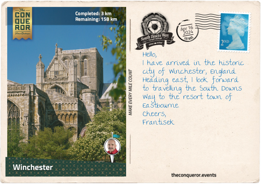
I chose to undertake this journey eastbound, preferring to leave the coast and its brilliantly white cliffs for the end. Starting in Winchester, Hampshire, I found the starting point at the Winchester City Mill. With a history dating back 1,000 years, it was a working mill until the early 20th century, when it was converted into a youth hostel. In the early 21st century, the mill underwent extensive restoration turning it back into a working mill and a museum.
Winchester is famous for its magnificent Gothic cathedral, one of the largest of its kind. Built between the 11th and 16th centuries, it is the longest medieval cathedral in the world (558ft / 170m long) with the longest and widest nave. Intricate stained glass windows decorate the cathedral with the most exquisite mosaic design found on the Great West Window. Monarchs and bishops have been buried at Winchester for centuries, but the most well-known burial is one of England’s greatest novelists, Jane Austin. Inside the church is a bust of William Walker, honouring him for saving the church from collapse. When the cathedral’s foundations sprung a leak, William, a deep sea diver, spent six years working underwater, placing concrete bags to stabilise them. For his service, William received the Royal Victoria Order.
Another significant building is the 13th century Great Hall, the only remains of Winchester Castle. The Hall was built by King Henry III, and on its wall hangs King Arthur’s Round Table. The massive tabletop is 18ft (5.5m) in diameter and weighs an enormous 2,600lbs (1,200kg). The current design is from the 16th century and was ordered by King Henry VIII. The table’s edge bears the names of King Arthur’s knights, including Sir Galahad, Sir Lancelot, Sir Gawain, and Sir Percival, to name a few. In the centre is a portrait of King Arthur.
Leaving historical buildings behind, I swung a right turn at The Bishop on the Bridge pub to walk along the banks of the River Itchen and past the Roman wall remains. Heading out of the city, I am on my way to the quaint village of Chilcomb and then toward Butser Hill.
km od začátku : 0035
Butser Hill
After Winchester, the trail entered the countryside, with hedgerows lining its path and large pastures beyond. Outside of Chilcomb, I passed an old barn raised on staddle stones. These traditional mushroom-shaped stones lift granaries or haystacks off the ground to improve circulation and keep the vermin away. I wondered about the contents of this old barn as I strolled by.
Feeling the subtle incline, I meandered through woodland, where vines seemed to take over every tree. Bearing left at a four-way crossing, I cut through a field and crossed a road onto a narrow path. To my left was Cheesefoot Head, a large amphitheater that, during WWII, was used for boxing events. It was also where General Eisenhower addressed the Allied troops before the Battle of Normandy, the largest seaborne invasion in history that led to the liberation of Europe during WWII.
Pressing on through meadows and road crossings, I came to a T-junction where I turned right and walked straight into The Milburys Inn for some pub grub. Replenished, I marched past the site that once was Lomer village, one of many villages that disappeared during the Middle Ages. At Beacon Hill, a National Nature Reserve, I climbed 660ft (201m) to its summit to enjoy views of Meon Valley and as far as the Isle of Wight. Several species of orchids and different types of chalk grassland inhabit the area. Drawn to the flowers are the pretty Chalkhill blue butterflies.
After Beacon Hill, tucked away in a cow paddock, was Exton Beacon, erected in 2012 to commemorate Queen Elizabeth II’s Diamond Jubilee. Less than a mile further, I walked through the pretty little village of Exton, sitting on the west bank of the Meon River. Exton may be small – population 200 – but it has been around since the Anglo-Saxon days back in the 10th century. The Shoe Inn and the 13th century church are the only community buildings in town.
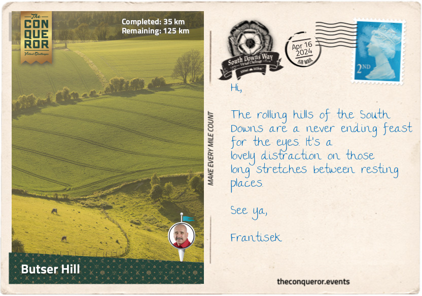
A further 8mi (13km) through the countryside and I arrived at Butser Hill, the original starting point of the Way. At 885ft (270m), Butser Hill is the highest point on the South Downs Way and is home to rare chalk grassland species. A mile further is the Queen Elizabeth Country Park. Designated an Area of Outstanding Natural Beauty (AONB), the park is one of the largest expanses of unbroken forest in the southeast of England. The park’s woodland, mostly beech trees, was planted in the 1930s. The park is twinned with the Queen Elizabeth National Park in Uganda, focusing on cultural exchange, conservation, and supporting local communities.
It’s time for refreshments at the Butser Roundhouse Café. Housed in a replica Iron Age roundhouse, I chose a lemon drizzle cake and a pot of English Breakfast tea. Consulting my map, I got a feel for the next stage of my hike to Amberley.
km od začátku : 0075
Amberley
After the beautiful Queen Elizabeth Country Park, I was delighted to walk through more woodland. This time I wandered through Coulters Dean Nature Reserve, where pretty wood anemones, violets, and primrose line the trail’s edges in spring. Half a mile further and I entered the county of West Sussex.
As the trail continued, narrowing once again, in the distance up on Tower Hill was the ruined folly of Uppark House. The house is more than 300 years old and has been remodelled many times over successive generations. As part of its fine interiors and collectible items, the most significant is a large 18th century doll’s house, one of few surviving from that era. Three storeys high, the interiors are intricate, containing silk-covered mahogany chairs, Flemish-style oil paintings, porcelains, and a fully decked-out kitchen. The dolls illustrating the upper class are dressed in fashionable clothes and made of wax, whereas the servants are made of wood and wear simple clothing. The house is in excellent condition, leading curators to believe it was bought as a curiosity and display item instead of for play.
The National Trust’s Harting Down, a large area of ancient chalk downland, was south of the village. A little further was Beacon Hill, developed as an Iron Age fort around 500 BC. It was a fairly steep climb to the top, but the effort was worthwhile for the stunning 360 degree views.
Two miles (3.2km) later, the trail skirted around a series of large Bronze Age burial mounds collectively called the Devil’s Jumps. Thought to be nearly 4,000 years old, they are very well preserved, measuring between 85-112ft (26-34m) in diameter and up to 16ft (4.5m) high. The name, though, is part of folklore. Apparently, the god Thor used to sit on a hill. One day the Devil, seeing the mounds, decided to jump from one to the next to alleviate his boredom. Thor wasn’t happy about it and threw a stone at the Devil, who subsequently fled.
Tucked away in a corner amongst the trees was a small, well-tended memorial for a 25-year-old German pilot called Hauptmann Joseph Oestermann. He was shot down by a British pilot at the start of WWII while two airmen parachuted to safety. Ironically, the British pilot was shot down later in the day over the English Channel. He survived but sustained injuries to his legs.
The walk over Bignor Hill follows an old Roman road. In the village of Bignor, north of the Way, is a prominent 3rd century Roman Villa full of exceptionally well-preserved and highly detailed mosaics.
I passed through the northern end of the Slindon Estate, a National Trust property focused on conserving the 1,400 hectares in its care. One of its major restoration projects was reconnecting the disjointed woodland called Northwood. Much of the ancient timber was cut down and used during WWI, and the land was converted to farmland. Over the last decade, the Trust planted more than 13,000 trees to fill the gaps and help restore the wildlife corridors. It’s regarded as the biggest man-made forest to date.
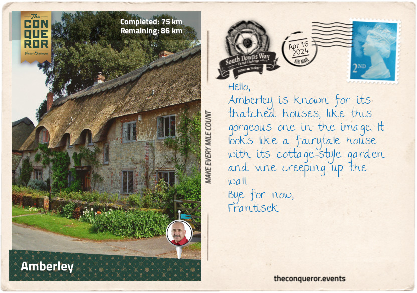
The trail led me down into the picturesque Arun Valley, where cowslips bloom in spring, carpeting the valley in a sea of yellow. Crossing the Arun River, I arrived in the small village of Amberley, where a 900-year-old castle was converted into a luxurious hotel - a splendid place to finish my day.
km od začátku : 0108
Peycombe/h2>
Walking uphill from Amberley, I followed the Way up on the ridge to Kithurst Hill, marking the halfway point of my journey. The trail dropped just before I crossed the busy highway and back up the hill to Chanctonbury Ring. A prehistoric hill fort topped with beech trees, Chanctonbury is famous for legendary tales. According to myth, one must walk around the Ring seven times backward on a dark, moonless night to summon the Devil, who will trade a bowl of milk or soup for one’s soul or wish. Spooky stories have been told where “thudding hooves of invisible horses can sometimes be heard,” or a ghostly lady on a white horse can be seen if the Ring is walked around three times. The tales have found their way into modern times, with UFO sightings recorded at the Ring.
As I approached Steyning Bowl, I passed by a memorial to local farmers, Mollie and Walter Langmead, ‘laid to rest on their cherished Downs.’ A bit further was a triangular cluster of trees called the Bramber Beeches. They were planted to commemorate the Sussex branch of the Women’s Institute diamond jubilee in 1979. The Institute is a century-old women only organisation focused on bringing women together and providing educational opportunities. Held in high regard, several British monarchs were members, including Queen Elizabeth II, her mother, grandmother, and daughter (who is a current member).
From here, I walked through the sleepy village of Botolphs, crossed the Adur River, and climbed onto the Fulking escarpment with views of Fulking village. Next was the National Trust’s Devil’s Dyke. This steep v-shaped dry valley was a trendy destination during Victorian times. Various transport ventures used to take visitors to the foot of the hill, including a funicular, a cable car, and a single-track railway. Remnants of all three can still be seen today. Nowadays, the area is popular with hang gliders and paragliders.
Just past the Dyke, I came upon Saddlescombe Farm, another property cared for by the National Trust. Farmed for more than 700 years, Saddlescombe was once in the ownership of the Knights Templar in the 13th century. The farm has several preserved buildings, a blacksmith’s forge, and a donkey wheel used to raise water from the well 50m below. The nearby woodland is home to a 1,000-year-old lime tree and a graffitied beech tree dated 1880, which today holds “the record as the single tallest native British tree in the UK.”
I finished this journey in Pyecombe, a village with two different settlements. The secondary settlement is called Pyecombe Street. The village split after the 1603 plague ravaged London and the surrounding countryside, forcing the villagers to move a quarter of a mile away.
With little else to do, the Plough Inn, serving travellers and locals since the Victorian times, seemed like an excellent place to rest and have a great feed.
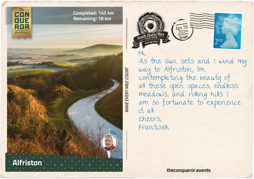
km od začátku : 0143
Alfriston
Having left Pyecombe, I turned right at the golf club and a short way down, facing north, I could make out one of the Clayton Windmills. Both from the 19th century, they are affectionately known as Jack and Jill. Relocated from Brighton, Jill is a working mill with a double-storey roundhouse, whereas Jack is a five-storey tower mill that was converted into a private residence.
I crossed into East Sussex county a mile (1.6km) before Ditchling Beacon. The Beacon is the highest point on the Way in Sussex and is owned by the National Trust. As is the Blackcap Nature Preserve, where I took a sharp right turn and walked through fields and woods to the A27 highway.
Crossing the highway on an overhead bridge, I soon passed beneath a railway via an arched tunnel that opened to a wide grassy valley. Before my 80th mile (129km), I happened upon a wooden fingerpost marking the Meridian Line, demarcating the Western and Eastern Hemispheres. Not far from here is the village of Rodmell, where Monk’s House, a 16th century weatherboard cottage, is known to have been the home of renowned author Virginia Woolf.
Swinging right, I walked through Southease and over River Ouse, one of five rivers in the UK with the same name. The name Ouse is derived from the Celtic word for water, making the literal translation as River Water. The Ouse in Sussex, with all its tributaries, runs over 140mi (225km) long and flows into the English Channel.
The trail traversed Ouse Valley, dotted with farms, woodland, and colourful wildflowers spread across the landscape. North of Firle Beacon is Charleston House, where Vanessa Bell, Virginia Woolf’s sister, resided and worked as a painter. It was here, along with Monk’s House, that the Bloomsbury Group - made up of artists, writers, and intellectuals - gathered to share their progressive thoughts and ideas.
Heading southeast, I arrived in Alfriston village. Its main street had a delightful collection of buildings, with the three local pubs as the most interesting. The oldest building, circa 1358, used to be a butcher’s shop in the 19th century and was owned by Stanton Collins, a legit butcher by day and smuggler by night. His shop was a convoluted maze of 21 rooms, 48 doors, and six staircases to hide the contraband. Smuggling was rife during Stanton’s times, and it was in the shop he and his gang planned a daring raid of a Dutch ship stranded in Cuckmere Bay. Sometime in 1831, Stanton was caught for stealing and promptly shipped off as a convict to Australia. According to records, he served his sentence and returned to England. Eventually, he migrated to New York, USA, where he lived out his remaining days.
Another significant building is the Star Inn. It was built in the 14th century as a religious hostel to accommodate monks and pilgrims on their way to Chichester Cathedral. Two centuries later, it was converted into an inn. Leaning against a wall outside is a red lion figurehead thought to have washed ashore from a wrecked ship and brought to Alfriston by smugglers, which could have been Stanton’s gang.
The third pub, the George Inn, was first licensed in 1397. Its half-timbered façade dates back even further to the mid-1200s. The Inn is known for the network of smugglers’ tunnels leading from the cellars.
Alfriston may be small, but its long history calls for a little more exploration before I move on.
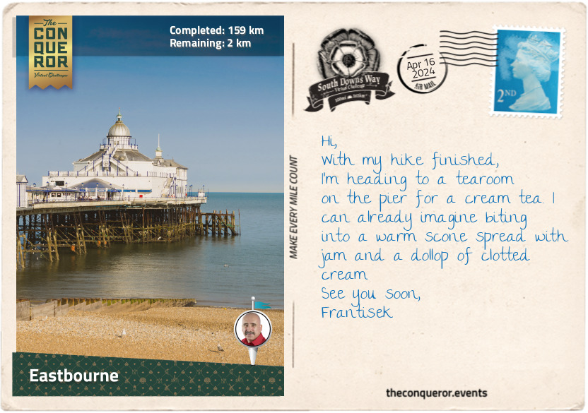
km od začátku : 0159
Eastbourne
I left Alfriston and started the final stage of my journey. I walked for about a mile (1.6km) beside Cuckmere River to the quiet village of Litlington. Pretty cottages and cottage gardens lined the narrow streets. A little out of town up on Hindover Hill was the Litlington White Horse, a chalk horse figure cut into the hillside in 1924. Cared for by the National Trust and regularly maintained with volunteers’ help, the horse measures 93ft (28m) long and 65ft (20m) high. An earlier cut from the 19th century existed on the same site, believed to have been done to commemorate Queen Victoria. The cut was fully covered by the early 1900s due to a lack of maintenance.
Southbound, I veered away from the river onto the clifftop to enjoy the lovely views of Cuckmere Haven. But as I inched towards the clifftop edge, I was met with the most beautiful sight - the chalky sea cliffs that this region is resoundingly known for. Referred to as the Seven Sisters, these series of cliffs on the English Channel coast are sea-eroded sections of the South Downs hills, and the dips in between are remnants of dry valleys. Each crest and dip has been individually named by locals. An eighth cliff is being created as a result of sea erosion.
The English Channel is the busiest shipping channel in the world, with shipwrecks across the centuries in the thousands. However, the most intriguing project I discovered was by the Maritime Archaeology Trust. Since 2019, the Trust has been researching and documenting the shipwrecks from World War I. They have mapped over 1,000 sunken ships off the English Channel coast. Many of them are fragile and extensively deteriorated. The Trust’s aim is to turn attention to these lesser-known wrecks and tell their story before they disappear.
One such story is of the wrecks HMS Nubian and HMS Zulu. Nubian was struck by a torpedo, blowing off its front section, but the rear remained afloat. On the other hand, Zulu had its rear blown off by a mine. Both were towed to the Chatham dockyard, where the two ships were joined together to make an entirely new one. With the names also joined, the new ship was launched as HMS Zubian.
Following the coastline, I climbed to Beachy Head, where the lonely red and white striped lighthouse stood in the shallow water below. The builders and construction materials had to be lowered from the clifftop by cableway to build the lighthouse. Erected in 1902, today, it is a popular visitor location and a terrific subject for keen photographers.
Arriving in Eastbourne, the east end of the South Downs Way, I was pleased to complete my walk in this seaside resort town. The shoreline was a beautiful mix of Victorian hotels, townhouses, and military fort. A 19th century pier was lined with entertainment venues and tea rooms. The pristine beach was a little chilly but a wonderful place to conclude my trip.