In the beginning, there was a great nothingness, an empty faceless void that the Māori called Te Kore. From this void came Te Pō, the realm of perpetual darkness, where the celestial parents, Ranginui (the sky father) and Papatūānuku (the earth mother), were tightly joined together in an eternal loving embrace. Many sons were born out of this union, living in the darkness between their parents. Yearning for light and a curiosity about what lay beyond their tight confines, the sons decided to separate their parents. One after the other, they tried and failed to break their parents' bond until it came to Tāne, the god of forests and birds. Tāne pushed and pushed with all his might, slowly separating his parents until Ranginui (Rangi) was high enough to become the sky, and Papatūānuku (Papa) remained where she was, becoming the earth.
Brought into the light, Tāne sought a female element to bear his children. Since none existed, he concluded that he must create and mould one from the red earth. As life was breathed into the new form, Hineahuone, the first woman, was born. Together they had several daughters, including Hinetitama, later known as Hine-nui-te-pō (goddess of death). She was an ancestor of Māui, who crushed him to death when he attempted to win immortality for humankind, making him the first man to die.
Māui was a demigod, a cheeky trickster and shapeshifter. Prematurely born, he was cast into the ocean by his mother. Protected by sea fairies, he was returned to shore as a live baby. He was found by his grandfather, Tamanui-ki-te-Rangi, who raised Māui and passed on all his knowledge and incantations. Māui later reunited with his mother and siblings. One day, the siblings refused to take him fishing, so he snuck onto and hid at the bottom of their waka (canoe).
The following day when they were too far from land to return, Māui used his grandmother Muriranga-whenua's jawbone - a gift to him - refashioned into a fishhook to cast into the ocean. Since his brothers wouldn't share any bait with him, he hit himself on the nose and used his blood instead. Soon he had a great bite and struggled to pull the fish. His brothers were unwilling to help, leaving Māui to recite an incantation to keep his line strong. Reeling his catch, Māui hauled a giant fish which today is known as Te-Ika-a-Māui (The Fish of Māui), the North Island of New Zealand.
This is the creation story in Māori mythology, the indigenous people of Aotearoa (New Zealand). The story of New Zealand's South Island diverges between the northern and southern Māori cultures and one that I will tell at a later stage.
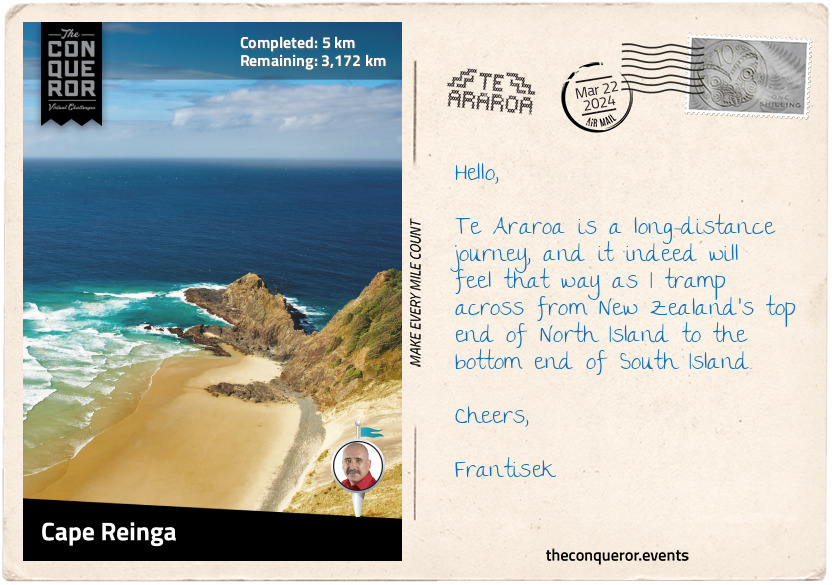
Traditional stories fill me with wonder and imagination. As I look at the map of North Island, I see the shape of a stingray emerging. The tail is at Cape Reinga, the island's northern point and the head is at the southern end in Wellington. The fins are the landmasses bulging out on either side. Can you see it?
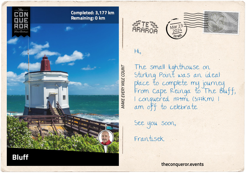
With excitement and a good dose of nervousness, I embark on a long-distance journey of 1974mi (3177km) through the entire length of New Zealand on the iconic Te Araroa. Beginning in Cape Reinga near the tip of North Island, I will travel south over various landscapes, through towns, and past Māori marae (meeting houses). I look forward to experiencing the contrast between the more populous North Island and the remote wilderness of South Island. Along the way, I hope to capture the stories, history, and spirit of this country and its people.
km od začátku : 0042
Maunganui Bluff Reserve
The trail took a right turn near the Cape Reinga car park and travelled the ridgeline along the coast, descending onto Te Werahi Beach. Wide and pristine, the beach led to peach-coloured dunes with views of Cape Maria Van Diemen. The cape was named by Abel Tasman, after the wife of Governor Anthony van Diemen. Tasman was a Dutch explorer who, in 1642, sailed past Van Diemen's Land (now Tasmania) and soon after sighted the west coast of New Zealand. The cape and a group of islands further west, the Three Kings, are the only two locations in New Zealand that retain the original name Tasman gave them.
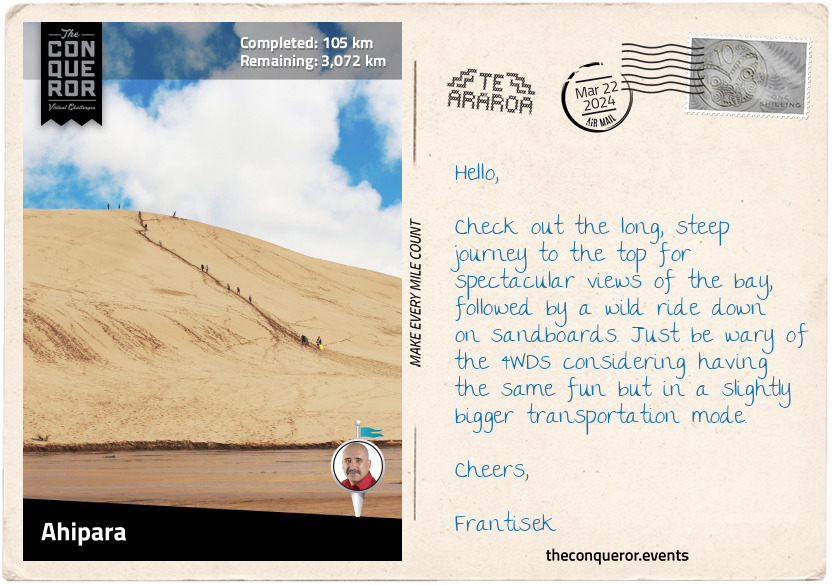
Continuing by the coast, I strolled onto Twilight Beach, back up a small hill through the bush, followed by a steep stair descent to Ninety Mile Beach and the Giant Sand Dunes. The dunes are 6mi (10km) long and up to 490ft (149m) high. A good fitness level is needed to climb to the top, but a sled ride hurtling down the sand would make it all worthwhile.
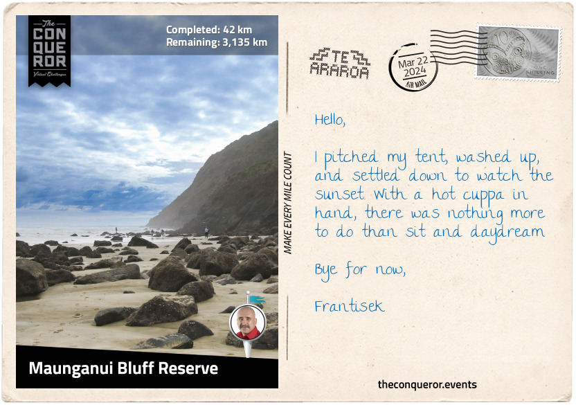
I took a break at Maunganui Bluff Reserve. It had a basic camping site and a rocky outcrop called Wakatehāua Island. The coastal vegetation was dominated by Pohutukawa, a tree that blooms with blazing red floral clusters during the summertime.
The Pohutukawa is New Zealand's symbol of Christmas and a sacred tree to the Māori people. At Cape Reinga is a gnarled Pohutukawa where Māori spirits begin their long journey to their ancestral home Hawaiki. Following the World Wars, the trees were planted en masse around Wellington's War Memorial to commemorate the fallen, including the Pacific Island volunteers who fought for New Zealand.
After setting up camp, I took a quick dip in the ocean to wash away the day's grit and sweat, settled into the evening with a hot cuppa, and watched the sun slowly disappear over the horizon.
km od začátku : 0074
Ninety Mile Beach
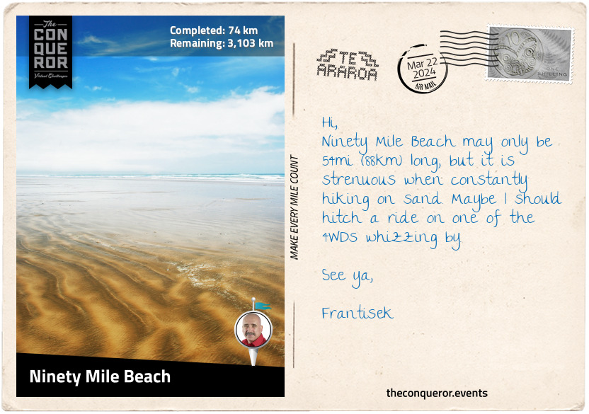
The Ninety Mile Beach is expansive and never-ending, stretching as far as the eyes can see. In the 1930s, it was used as a runway for an airmail service from Australia. Luckily, I didn't need to worry about airplanes coming in for a landing as it's no longer in use. The beach, however, is an official highway with 4WD enthusiasts motoring on it during low tide.
The reason for the name "Ninety Mile" is a puzzling question because the beach stretching from Tiriparepa/Scott Point near Cape Reinga to Ahipara Bay is only 54mi (88km) long. Early European settlers apparently figured that their horses or livestock could travel 30mi (48km) per day and take three days to arrive at their destination. Simple mathematics concluded that the beach was 90mi (145km) long. The settlers didn't consider that travelling on the sand was much slower than travelling on the road.
In Māori, the beach is called Te Oneroa-a-Tōhē, meaning the 'long beach of Tōhē '. The name commemorates Tōhē, an elderly chief of the Ngati Kuri people who lived in Kapowairua (Spirits Bay) near Cape Reinga. One day Tōhē, very old at this stage, decided to take a walk south to see his daughter one final time. Although he died before reaching his daughter, Tōhē named over 100 places along the western coast of the far north of North Island.
Each year at the end of March, the beach hosts the Snapper Surf Casting Competition, where the one-species-of-fish competition makes up the five day event. More than 1000 anglers are drawn to the event, vying for the largest snapper and the enticing prizes. The heaviest snapper thus far weighed 26lbs (12kg). Anyone up for some surf fishing?
km od začátku : 0105
Ahipara
My trek on Ninety Mile Beach ended in Ahipara, a small community of 1450 residents. It used to be known as Wharo, 'stretched out', because Chief Tōhē ordered a servant to measure the distance between the receding tide and the water level by counting the number of arm spans.
With its unspoiled beach, Ahipara is a popular spot for surfcasting (beach fishing), land yachting (a three-wheeled vehicle powered by sail), and quad biking. But a fun experience was doing the 'Tuatua Twist'. All I had to do was dig my feet in the shallow water during low tide and twist until I felt the tuatua's (clam) edge. These shellfish are delicious when steamed in a mixture of garlic, butter, herbs, chili, and white wine or water. Another option is to make clam fritters mixed with curry powder, diced onions, and tomatoes, then shallow fry and serve with a fresh salad.
Left of the town was Te Kōhanga (Shipwreck Bay), a place appreciated by surfers for its excellent surf breaks. Historically though, the bay is known for its many shipwrecks. One story is of an Australian-built barge called The Favourite that ran aground in 1870. All that is visible of the wreck, usually at low tide, is a wrought-iron crankshaft. Sometime in 2014, it was vandalised and weakened by a local protesting oil drilling prospects. Heavy swells damaged it two years later, causing a safety hazard. Surfers used it as a safety marker for the boiler that lay underwater. To locals, it felt like "an old friend is gone". As such, in 2018, the crankshaft was restored and reinstalled on top of the boiler. The old friend was back, and the surfers had their safety marker.
South of Ahipara is the Herekino Forest, home to rare and threatened species, the North Island brown kiwi and long tailed bat. Herekino is a kauri-podocarp-broadleaved forest, one of three types of indigenous forests that usually occurs in the north of North Island. Pohutukawa, Kohekohe, Puriri, and Karaka are the most common trees. Sadly, the forest is closed due to a disease affecting the kauri trees. Because of it, the route that once went through the forest has been diverted. It now travels via the highway to Kaitaia.
km od začátku : 0222
Rainbow Falls
The 8mi (13km) stretch along the road from Ahipara was somewhat monotonous, with farmland and occasional homesteads dotting the edges of the highway. Yet the sky was clear, the air breezy, and the road was thankfully quiet.
Kaitaia is the last town on State Highway 1 and a major centre in the Far North of New Zealand. Its economy is based on a number of industries: forestry, tourism, avocado farms, dairy farming, and viticulture.
I passed Centennial Park, where a D221 steam tank locomotive was displayed. The locomotive was one of a batch of six built in Glasgow in 1880 and saw a variety of duties with the New Zealand Railway until 1918. It was later sent to Northland (the northern region of North Island), where it was meant to serve on the planned extended line to Kaitaia. The railway line was meant to cut through or around the Maungataniwha Range, but plans were abandoned in the mid-1930s when they were no longer viable. However, State Highway 1 runs through the range and is considered one of the twistiest, hilliest sections of the entire highway.
The locals call the mountain range Mangamuka after the town and river of the same name. The forest within it is home to giant kauri trees that survived the logging era of the early 20th century. As I trekked through the woods, the steep climb had minimal views. Orange triangles marked the trail, a welcome sight, ensuring I remained on the right track. An added challenge to the steepness was the humid air and muddy ground, slowing my pace. Trudging on through Omahuta and Puketi Forests, I finally reached the end and was back around farmland and meadows.
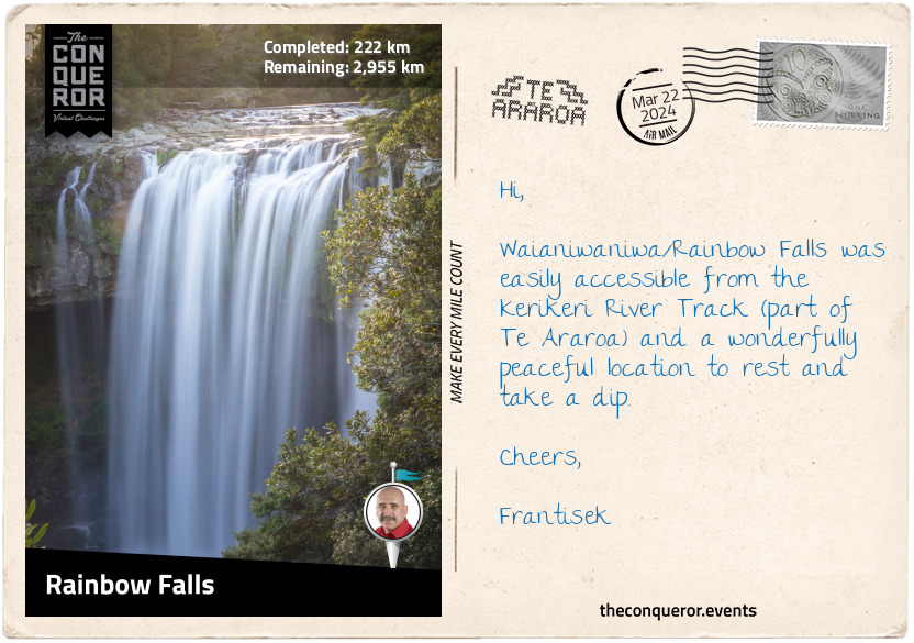
Between the small village of Waipapa and Kerikeri is the lovely waterfall known as Waianiwaniwa (Rainbow Falls) which translates as Waters of the Rainbow. It is a single-drop waterfall that plunges 88ft (27m) into a large swimming hole. The waterfall is surrounded by native bush, making me feel as if I was in a secluded place, all peaceful except for the tumbling sound of the waterfall. This was an ideal place to rest and refresh.
km od začátku : 0247
Waitangi Treaty Grounds
The Kerikeri River Track was on the north side of the river, leading to the low but amazingly wide Wharapoke Falls. I continued around the river's bend to a footbridge and crossed over to visit two of New Zealand's oldest surviving colonial buildings. Kemp House is a timber structure erected in 1822, and for a short period, it was home to Rev John Butler, New Zealand's first clergyman. Near it is the Stone Store, built out of stone and opened in 1836. Both buildings were constructed by pioneering missionaries at Kerikeri Mission Station. The station was a key site during the early period of Māori-European contact that led to the signing of Te Tiriti o Waitangi (Treaty of Waitangi). Aside from being the oldest buildings, both properties boast two of the oldest pear trees. The one at Stone Store was planted in 1819, and the one at Kemp House, which still bears fruit, was planted before 1828 (the exact date isn't known).
I continued my journey through Waitangi Forest, which consists of pine and macrocarpa (Monterey cypress) trees. The route passed commercial forestry until I reached the Te Araroa Cairn, which marked the opening of the first Te Araroa track in 1995. Called the Waitangi-Kerikeri Walk, it connects the two historical settlements. Part of it follows an old Māori trail that was initially linked to the Māori settlement of Okura, which has since vanished.
Taking a short detour to climb to the summit of Mount Bledisloe, I marvelled at the panoramic views of Waitangi, the Bay of Islands, and the Kerikeri Inlet. Descending back onto Te Araroa, I left the forest behind and arrived at the Waitangi Treaty Grounds.
Waitangi Treaty Grounds is a significant location in Aotearoa/New Zealand. On 6 February 1840, Māori chiefs and Captain William Hobson, on behalf of the British Crown, signed New Zealand's founding document – the Treaty of Waitangi. Since 1934, the anniversary of the signing has been commemorated as Waitangi Day.
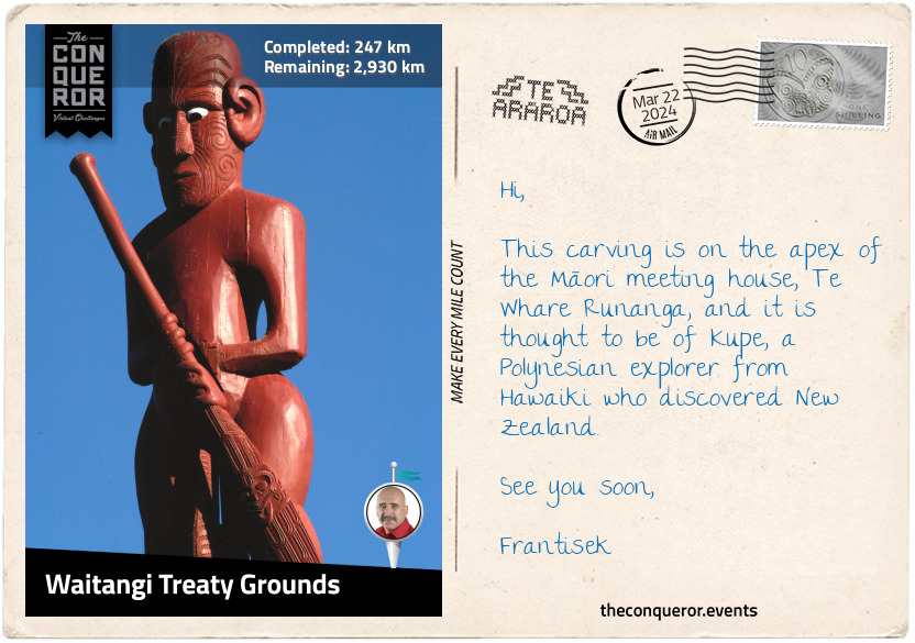
The Waitangi Treaty Grounds was gifted to the nation in 1932 by the then Governor General, Lord Charles Bledisloe. With beautifully manicured lawns, the grounds include the Treaty House, where the document was signed, and Te Whare Rūnanga, an intricately carved meeting house in traditional Māori form. Facing each other, the two buildings signify the "partnership between Māori and the British Crown" on which the country was founded.
Beneath an open shelter is Ngātokimatawhaorua, the world's largest ceremonial waka (canoe). Built in 1940 to celebrate the centenary of the Treaty's signing, the waka was carved "as a symbolic representation of each iwi (tribe)." The waka is launched every year on Waitangi Day.
The Waitangi Flagstaff flying three official flags is located in the middle of the lawn. The middle flag is New Zealand's national flag (1902-present) with Te Kara the flag of the United Tribes of New Zealand (Te Kara o Te Whakaminenga o Nga Hapu o Nu Tireni) to the north (1834-present), and the British Union flag to the south (1840-1902).
Taking time to absorb the history, I take one last look across the bay and continue with my journey.
km od začátku : 0325
Whananaki
Crossing the Waitangi Bridge, I took the coastal walkway to Paihia, the main tourist destination when visiting the Bay of Islands. It was here that, in 1832, the first cricket game was mentioned in the diary of Henry Williams. He was the leader of the Church Missionary Society, building the first church in Paihia. He was also the translator of the Waitangi Treaty into the Māori language. His wife Marianne was a pioneering educator in New Zealand, establishing schools for Māori children and adults and teaching the children of the missionary.
The first New Zealand sailing ship, Herald, a 55-ton schooner, was built in Paihia and launched in 1824. Its maiden voyage was to Sydney, Australia. Barely two years later, Herald was wrecked attempting to enter the Hokianga Harbour on the west coast. The ship appeared on a 5 cent New Zealand stamp in 1975, and a memorial stone was placed on the beach in town.
My coastal walk ended at Opua, a small village that is the northernmost port for overseas vessels. Myra Larcombe, a resident of Opua, was one of the first female police officers in the country and the first female police officer in Northland. Myra was also a competitive swimmer and a swim coach. In 1998 at the FINA World Master Championships, she set the 200m butterfly record. She was 71 years old, and her record stood for nine years. As co-founder of a swimming club and later lifetime member, in 2018, Myra was awarded the Queen's Service Medal for services to swimming.
Catching a ferry, I crossed Veronica Channel to Okiato and headed inland. The trail led me through a kauri grove within Russell Forest, through the hamlets of Punaruku and Helena Bay, to Whananaki.
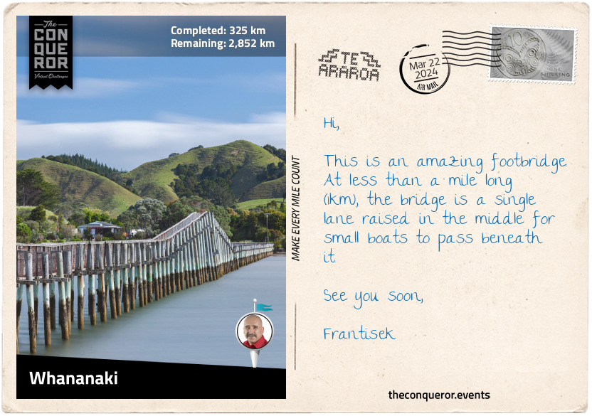
Whananaki North is a small village on the banks of an estuary that separates it from Whananaki South. The highlight of this location is the wooden footbridge. Built in 1947 from local timber, the bridge stretches 1300ft (400m) across the estuary. It is the longest footbridge in the Southern Hemisphere and a great fishing spot. The main reason for its construction was to enable children from Whananaki South to attend school in Whananaki North. Before the bridge, the school teacher would row a boat across the estuary twice daily to ferry the children back and forth.
km od začátku : 0390
Smuggler's Bay
Te Araroa zig-zagged around the base of the many hills I passed. At Sandy Bay, I took a right turn and moved away from the coastline. Trekking through forests and farmland, almost in an arc shape, I found myself back on the coast at Ngunguru.
Ngunguru is a small settlement beside a river and a long low sandspit. In 1832, the sandspit was the site of a battle between two tribes, Te Waiariki and Waikato. The Waikato were led by Te Wherowhero, a warrior who later was appointed the first Māori King.
The route works its way south parallel to the coast, going through the small villages of Pataua and Taiharuru and onto Ocean Beach for a seaside meander for the next 4mi (6.5km). I climbed a steep section onto Te Whara Track past a WWII radar station to a scenic lookout at Bream Head. Here, an incredible panoramic view unfolded with several islands in the distance.
Te Whara Track follows the ancient footprints of the Māori chief Manaia. It is believed the ancient trail is at least 700 years old. The track was named after Manaia's wife, who is said to have insulted Puhi-Moana-Ariki, an early ancestor of the Ngapuhi iwi (tribe). Puhi, unhappy, turned her to stone, and the up-thrust rock at the easternmost point of Bream Head is said to be Te Whara standing.
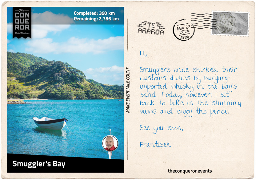
I trekked through stunning coastal forests and descended onto the small beach of Smuggler's Bay, which, as the name suggests, was once used by smugglers to bury whisky in the sand. These days, though, the bay is a beautiful, quiet spot. Enjoying the peace, I took a load off, dipped my toes in the sea, and enjoyed the views over the horizon.
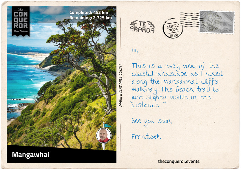
km od začátku : 0452
Mangawhai
Following the coast, I walked to Whangārei Heads, a locality and volcanic promontory. Taking a short side trip, I hiked up to the summit of Mount Manaia for an aerial view of the Whangārei Harbour and Mount Aubrey. Taking a short boat ride, I crossed the bay to Marsden Point, a broad and flat peninsula that makes up the southern part of the harbour entrance.
Heading along Marsden Point Beach at Bream Bay, I veered off at the northern point of Ruakākā Beach into a town of the same name. Ruakākā in Māori means the nesting hole of the kākā, a native parrot that nests in the cavities of hollow trees. The kākā is a large parrot species closely related to the kea, a parrot species found on South Island. Its current conservation status on the North Island is At Risk (Recovering), an encouraging sign since the species was slowly disappearing due to loss of habitat and reduced abundance of food.
Finding myself back in the forest, I hiked up to the crest of Bryndewyn Hill. Although some parts of the trail have been stepped to ease the burden, the trail rose and fell steeply in some sections. The forest is Kānuka regrowth, a tree shrub in the myrtle family and endemic to New Zealand. It has white or pink flowers and is an important food source for geckos. Just like its cousin, the Mānuka tree, the Kānuka is used to produce honey. Its flavour is described as "sweet with a light butterscotch note and a delicate floral finish." All I need is a couple of slices of bread to smear some honey on and gobble it up.
At the trail's end was a kissing gate that led me to more road walking and finally to Mangawhai Cliffs Walkway. The path travels along the clifftop with stunning sea views from Bream Head to Coromandel Peninsula. A section of the trail was on boardwalk, making it easier to walk until I reached the beach and finished this section at Mangawhai Heads.
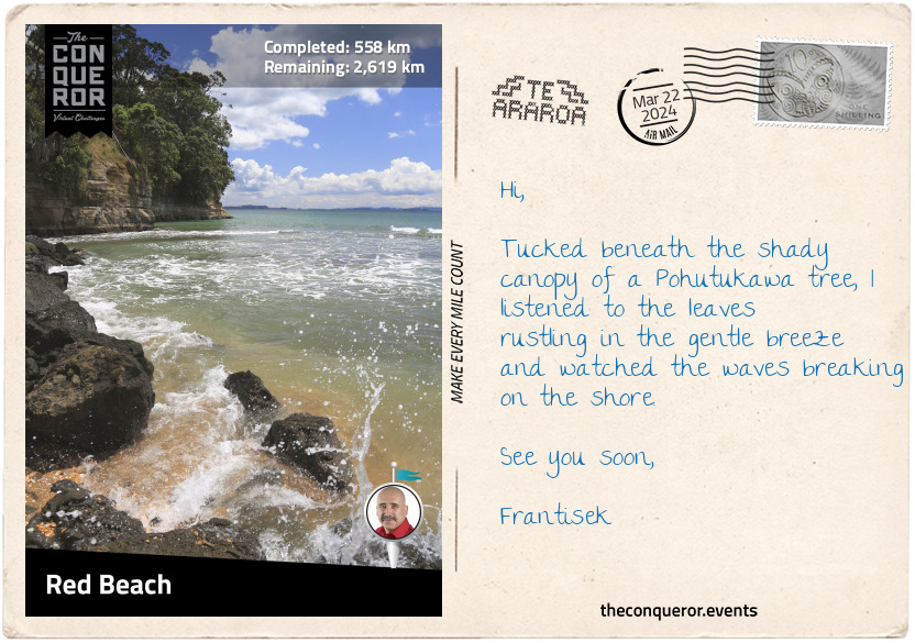
km od začátku : 0558
Red Beach
Having left Northland with Cape Reinga far behind, I entered the Auckland region. Combining beach and inland travels, I trekked through several small towns and took a brief detour up to the Dome Forest Lookout for views of the Mahurangi Peninsula and Hauraki Gulf. On a clear day, Auckland's Sky Tower can be glimpsed.
Exiting the forest, I arrived in the small village of Puhoi, which was settled in 1863 by a group of Bohemian migrants. Obtaining parcels of land from the government, the migrants were unaware that the free land was a densely forested hill and the only way they could farm it was by hacking their way through the bush to clear it. Despondent, disillusioned and without funds, the Bohemians had no alternative options but to work the land. They were fortunate that the local Māori chief Te Hemara Tauhia was an honourable and intelligent man who knew that the Bohemians were on the verge of starvation. Time and again the chief loaded their boats with fresh produce and taught them how to live off the land. In time the migrants’ hard work paid off and the land began to provide its own food. The church was finally completed in 1881 and continues to serve the community. The Puhoi Town Library is one of the smallest libraries in New Zealand. The building is tiny, yet it manages to hold more than 4,000 books.
As the trail wound back to the coast, I passed through Waiwera, which was once famous for its hot water springs. It was reputedly visited by early Māori and later promoted by Robert Graham, a politician who established a health resort here. It has since closed down.
Trekking via the beach, I passed through Orewa, which used to be part of the kauri gum-digging trade a century ago. Today, it is a suburb of Auckland.
A little further was the suburb of Red Beach with a beach of the same name. Sandwiched between the Orewa River and Weiti River, the suburb is a hive of marine activity. Keen paddle boarders, boogie boarders, kayakers, and swimmers can be found enjoying the waterways. The beach is beautifully lined with Pohutukawa trees. While close to Auckland, it's still far enough to escape the city's hustle and bustle. Unsurprisingly, the beach's name originates from the red-coloured sand.
I found myself a shaded spot beneath a Pohutukawa, laid out a beach towel, and whiled away the rest of the day.
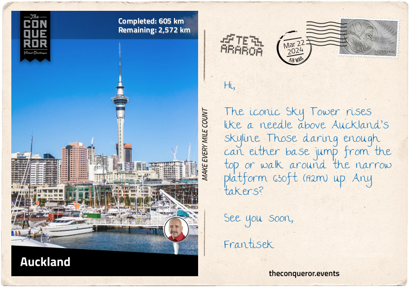
km od začátku : 0605
Auckland
Auckland was the capital city of New Zealand from 1841-1865 and was named after George Eden, 1st Lord of Auckland. The city was first settled by Māori around 1350, with fortified villages built on the volcanic peaks. Before European arrival, the population was about 20,000, but the arrival of firearms caused intertribal warfare with devastating effects. Tribes without weapons sought refuge elsewhere and the population had dwindled by the time the Europeans landed. Following conflict between Māori and Europeans, the capital was moved to Wellington. However, the city continued to grow and expand; today, it is an economic hub and major gateway to the country.
The iconic Sky Tower, a telecommunications and observation tower, is one of many architectural landmarks in the city. The Sky Tower, at 1076ft (328m), is the tallest tower and building in the Southern Hemisphere. Views over Viaduct Harbour and up to 51mi (82km) can be seen from the SkyDeck on the 60th floor. I'll be enjoying dinner on the 52nd floor in the revolving restaurant.
Geographically, Auckland is situated like no other city. Surrounded by various waterways, it is flanked by two large harbours, Waitemata Harbour to the north and Manukau Harbour to the south. To the east is the Hauraki Gulf and to the west is the gateway to the wild West Coast beaches.
Geologically, the city is surrounded by 53 volcanic centres and its hills are covered by rainforests. Auckland sits on a monogenetic volcanic field, meaning the group of volcanoes erupts only once. That holds true except for Rangitoto Island, which has erupted many times, although the last time was around 550 years ago.
With so much water surrounding Auckland, it's no surprise that it is dubbed the "City of Sails" and that sailing is a popular activity. Amazingly there are more than 135,000 registered yachts, with nearly 1 in every 3 households owning a boat. With that in mind, I think I'll head down to Westhaven Marina and see if I can get out for a sail for the day and watch the daredevils bungee jump from Auckland Harbour Bridge.
Lastly, Auckland was the home of Edmund Hillary, who, along with Tenzing Norgay, became the first climbers to summit Mount Everest. Hillary also reached the South and North Poles, making him the first person to do all three expeditions.
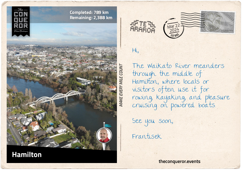
km od začátku : 0789
Hamilton
About 14mi (22km) before Hamilton is the town of Ngāruawāhia, one of the oldest and most historic settlements in the Waikato Region. Near the confluence of the Waikato and Waipa Rivers is the Tūrangawaewae House, the headquarters of the Kingitanga (Māori King Movement), a political institution since the 1850s and the official residence of the Māori King. The building is a blend of European and traditional Māori architecture.
Adjacent to the building is the large steel sculpture, "The Kings' Mask”, created by artist Inia Te Wiata. It features a traditional Māori facial tattoo with sandstone carvings below the neck. A plaque describes the sculpture as a representation of the first two Māori kings – Pōtatau Te Wherowhero and his son Tāwhiao – and pays tribute to their leadership during difficult times and urging peaceful co-existence with the Pakeha (non-Māori).
To put this into context, the Māori did not have a central monarchy like the British. They lived as independent tribes led by a chief. As the European settlers grew in numbers, so did the demand for Māori land. Powerless to negotiate, some Māori from the central north wanted to unite the tribes under one sovereign and began searching for a potential king. Many chiefs were approached but declined the role until the Waikato chief Pōtatau Te Wherowhero reluctantly agreed and was crowned in this very town.
Pōtatau passed away two years later, and his son Tāwhiao inherited the crown. Tāwhiao reigned for 34 years during one of the most turbulent times in Māori history. The crown was passed down to descendants, with Tūheitia Paki as the current king. His mother, Te Atairangikaahu, was the first Māori queen, serving for 40 years, making her the longest reigning Māori monarch.
My next stop was Hamilton, the biggest city in the Waikato region. The Waikato River flows through its centre, which was the site of several Māori villages before European settlers. Land confiscation by the Crown led most villagers to abandon their homes.
Hamilton is a bustling city with a riverside arts and culture precinct that includes the Waikato Museum. Exhibiting regional and international works, the highlight at the museum is the 200-year-old waka (canoe), Te Winika. Carved by Māori from the west coast of the Waikato region, the waka was buried in mudflats in the late 1800s to protect it from the British during the Māori Land Wars. In the 1930s, it was excavated, restored, and later gifted to the museum.
One final location I wanted to visit was Hamilton Gardens, a 54ha public park. At the park's southern end are a series of themed gardens from Italian Renaissance, Tudor, and Chinese Scholar's styles to Ancient Egyptian, Japanese and Indian styles. It also showcases Māori gardening methods at Te Parapara Garden.
km od začátku : 0837
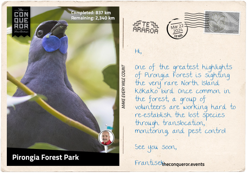
Pirongia Forest Park
Leaving Hamilton, I trekked southwest to Pirongia Forest Park. The park included three extinct volcanoes: The Cone, which the trail crossed, Mount Pirongia, and Mount Karioi. A densely forested park, the vegetation changed the further up I climbed.
At the bottom were rimu and totara trees, endemic to New Zealand, and ferns in the understory. The rimu is a large evergreen coniferous tree. Māori used it to make canoes, spears, and other tools. The gum was applied to wounds to stop them bleeding. The totara is a podocarp tree species known for its large girth. The Pouakani Tree is the largest living totara. It is over 115ft (35m) tall with a circumference of 157in (4m).
Hardier plants were further up with the likes of kamahi and horopito. Kamahi is an evergreen shrub found in abundance throughout the North Island. It is used as a chest tonic or to make Kamahi honey. Horopito is a woody flowering tree. Its leaves have a pepper-like taste and have been used as a cooking spice. The fresh leaves were chewed to relieve toothaches or to treat external wounds like cuts, bruises, or burns.
Near the summit, the park was filled with mountain flax, coprosmas, and more ferns. The mountain flax is a perennial plant with yellow-greenish flowers favoured by hummingbirds for its nectar. Coprosmas are related to coffee plants, and it is said that coffee can be made from its seed.
About 4mi (6km) off the main trail is the kahikatea tree, known for its grand height of 218ft (66.5m). It is the tallest recorded native tree in New Zealand.
km od začátku : 0890
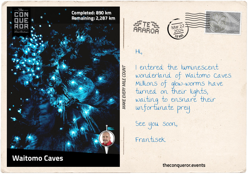
Waitomo Caves
After plenty of beach walking, forest trekking, and town meandering, it's time for an underground expedition at Waitomo Caves. Known to the local Māori for centuries, the cave system was first explored in 1887 by local chief Tāne Tinorau and English surveyor Fred Mace. They built a raft from flax stems and, with candles, floated into the caves on the underground stream.
Tāne had returned many times, and with his wife, he opened the cave to visitors. In 1906, the government took over the cave's management for the next 80 years when the chief's descendants regained ownership.
Waitomo Caves is a massive cavern system created over the last 30 million years. Throughout the Waitomo region, there are around 300 limestone caves. The Glow-worm Cave is the most popular, covered with millions of carnivorous glow worms, called Arachnocampa Luminosa, that twinkle like fairy lights in the darkness. The light they emit attracts insects on which they feed. When they mature, they turn into flies.
The upper cavern was filled with stalactites and stalagmites. Some joined together, forming a column. They are beautiful natural wonders that take millions of years to develop. Next to it was the Banquet Chamber, which was used as a luncheon spot in the early days of tourism. On the lower level is the tallest chamber, with a high vaulted ceiling known as the Cathedral.
Another worthy cave was the solar-powered Ruakuri Cave, with its dramatic man-made spiral entrance. But what truly piqued my interest was the rafting tour. An adrenaline-filled adventure that started with an abseil down a vertical shaft, ziplined through a glow-worm cave, climbed an underground waterfall and finished on a tube in fast-flowing water.
km od začátku : 0906
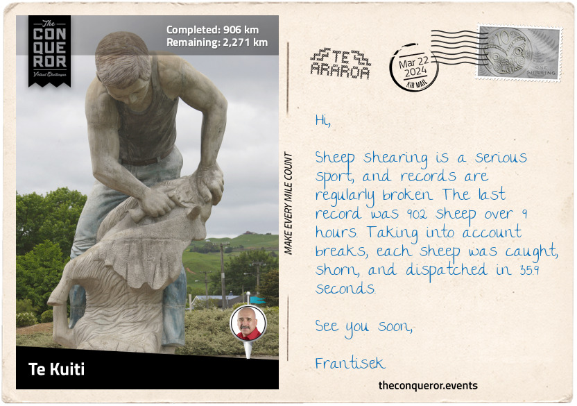
Te Kuiti
"The Sheep Shearing Capital of the World" is what Te Kuiti is best known for. Although in the 19th century, shearers were not seen in the best light, today, they are revered as "sporting heroes," as illustrated by the town's 20ft (6m) tall statue. Local world champion shearer, David Fagan, has won the Golden Shears title a staggering 16 times and, for services to shearing, has received multiple awards, including the Knight Companion of the New Zealand Order of Merit. Another local champion sheep shearer is Kerri-Jo Te Huia, who in 2012 broke the record by shearing 507 lambs in 8 hours (the previous record was 470).
This small town produced numerous notable people. Iconic artist Diggeress Te Kanawa was a master weaver who applied various weaving techniques to ensure their survival. She contributed extensively throughout her life to the community and abroad. She was recognised for her service with several honours and awards, including the Queen's Service Order and New Zealand Order of Merit.
Colin Meads is widely regarded as the best rugby player in New Zealand. He was named the Player of the Century in 1999 and inducted into several Halls of Fame. He played for the All Blacks national team for 14 years. Rugby writer Lindsay Knight wrote, "As a sporting legend, Meads is New Zealand's equivalent of Australia's Sir Donald Bradman or the United States of America's Babe Ruth." Aside from being an exceptional player, Meads was considered an "uncompromising, loyal, and humble person." He was also awarded the New Zealand Order of Merit and Member of the Order of the British Empire for services to rugby. A statue of Meads was erected in the town, surrounded by boards telling his story.
Many more individuals from Te Kuiti have made their mark in the world, contributing to the community and New Zealand.
km od začátku : 1015
Maramataha Bridge
The Timber Trail is one of many connecting trails of Te Araroa. Designed as a long-distance cycleway, it winds through the Pureora Forest Park for 52mi (85km). It is a relatively new Te Araroa section that opened in 2013. Local Māori knew this area as Te Pureora-o-Kahu (the life-giving ritual of Kahu), where the ancestress Kahu performed rites to help her recover from illness.
Prior to European settlement, Pureora was a dense virgin forest that became part of the logging industry in the 1940s. Large sections of the forest were felled when thirty years later, environmentalists stepped in demanding protection from further logging. Successful in their protest, the government preserved the remaining forest. Today, it is one of the last intact broadleaf podocarp forests in the world and home to a variety of birds, including the North Island Robin, kererū (native pigeon), and kākā (large parrot).
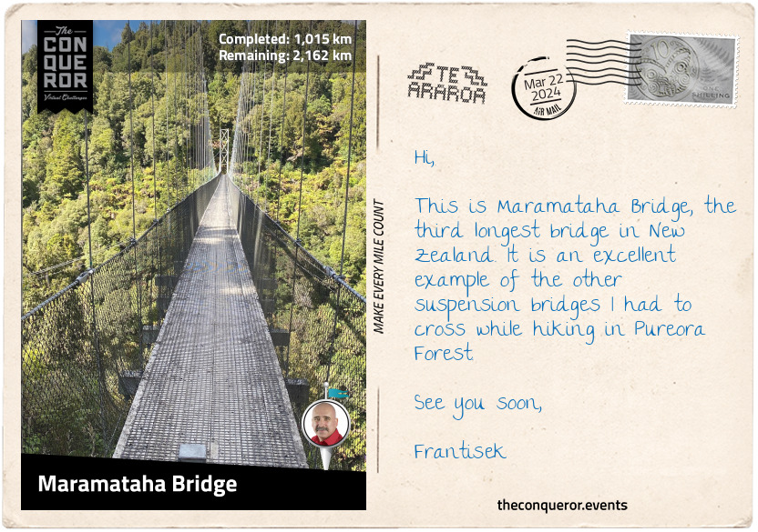
Trekking through the stunning forest, I marvelled at the tall trees and breathed in their scent and the purity of the air. I reached the highest point on the trail at 3186ft (971m), with great views of Lake Taupo, a crater lake that is also New Zealand's largest lake. One of the main attractions on this trail is crossing eight suspension bridges. Three were more than 328ft (100m) long.
The first suspension bridge was at Bog Inn Bridge, followed shortly after by Orauwaka Bridge. These suspension bridges are amazing engineering constructions. Each one was solidly built with wooden floors reinforced with steel mesh, steel mesh sides, and lots of steel cables acting as supports. Only subtle movements were felt as I crossed while taking in the vastness of the forest and the valley below.
I passed the Piropiro Campsite in a large open field surrounded by forest and continued to Maramataha Bridge. At 463ft (141m) long and 174ft (53m) high, the bridge is the third longest in New Zealand. It is a fabulous single-track non-vehicular bridge with the Maramataha River flowing beneath.
This was an excellent place to rest and take in the sounds and smells of the forest.
km od začátku : 1074
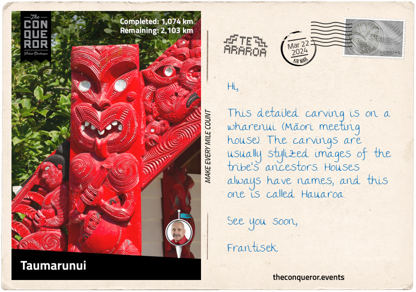
Taumarunui
I followed the Timber Trail to the Ongarue Tramway. This defunct bush tramway operated between the early to mid-20th century. Crossing a few other suspension bridges, I enjoyed the Ongarue Spiral, a loop on the main tram line going through a tunnel. The loop was meant to ease the trams' grading when travelling through this area. From here, I continued through scrub and private farmland, and the last mile was along a quiet road into Ongarue.
From Ongarue, I waltzed into Taumarunui, a small town on the upper side of the Whanganui River and the Ongarue River to its west. It was once a Māori settlement and a vital canoe route linking with river settlements downstream.
A unique experience in town is the Rail Cart Adventure at Forgotten World. It is an 89mi (142km) tramway journey in an open buggy – imagine golf carts - on rails. The route is from Taumarunui to Stratford, travelling through 24 tunnels and crossing 98 bridges. The longest tunnel is a mile (1.6km) long. Even shorter and more thrilling is a cart ride through 20 tunnels, followed by a helicopter flight over Whanganui National Park and a jet boat ride on the Whanganui River.
For a quieter experience, the nearby family-run lavender farm had a café serving tea and scones. It seemed like an ideal location to sip some tea, admire the purple lavender flowers, and take in their sweet scent.
km od začátku : 1159
Tongariro National Park
In the beginning, the priest, Ngātoro-i-rangi sailed from his ancient homeland of Hawaiki on a great ocean-going canoe. When he arrived in Aotearoa (New Zealand) near Matata (Bay of Plenty), he headed inland and southward, reaching Lake Taupō. Climbing the nearest mountain, south of the lake, with his companion Ngāuruhoe, he claimed it as his own and called it Tongariro. Caught in a blizzard, he called to his sisters to send him the sacred fire they brought from Hawaiki. The sisters sent him geothermal fire from the Pacific Ocean through an underground passage, the Taupō Volcanic Zone, and up to Tongariro. It arrived just in time to save him from freezing. However, it was too late for Ngāuruhoe, who remains frozen as the volcanic cone of what is known as Mount Ngāuruhoe, located next to Mount Tongariro.
Ngāti Tūwharetoa is an iwi (tribe) descendant from Ngātoro-i-rangi and the traditional custodian of Mount Tongariro. In 1887, Chief Horonuku Pataatai te Heuheu Tūkino IV extended custodianship of Mount Tongariro, Mount Ngauruhoe, and part of its neighbouring Mount Ruapehu to the people of New Zealand. He believed that sharing guardianship with the British Crown would ensure the preservation of the land, free from development and exploitation.
In 1894, Tongariro National Park was formally established. It was the first national park in New Zealand and the sixth in the world. Dual World Heritage status was conferred on the national park in recognition of its remarkable volcanic landscape and significance to Māori culture.
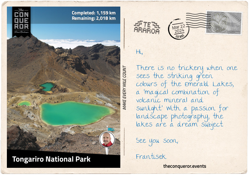
Entering the park from the north, I passed the Ketetahi Falls and hiked up the east side of Mount Tongariro for a view of the Blue Lake and further along the gorgeous Emerald Lakes. As I descended from the lakes, I found myself in a vast desolate terrain on the Tongariro Alpine Crossing with Mars-like features surrounded by barren hills. The trail led between the peaks of Tongariro and Ngāuruhoe to Whakapapa Village. North of the village is the luxurious Chateau Tongariro and its 9-hole golf, known to have the highest elevation in New Zealand. Anyone for a round of golf?
Southside of the village is the tallest mountain on North Island, Mount Ruapehu, an active stratovolcano that has erupted many times over the last century. At 9177ft (2797m), Ruapehu has three major peaks, a crater lake, and 18 glaciers.
The Lord of the Rings fans would delight in exploring this mountain, walking in the footsteps of Sam and Frodo, as the park was the filming location of several scenes. Mount Ngauruhoe represented Mount Doom. Its symmetrical cone was digitally created because the summit is sacred to Māori culture, and filming was not permitted. Mount Ruapehu was the setting for Emyn Muil, the labyrinth of hills where Sam and Frodo came across Gollum in the Fellowship of the Ring. The Whakapapa Ski Field on the west face of Ruapehu was the location for Sam and Frodo's various mountain trekking scenes. Peter Jackson's vision of Lord Sauron's lair was brought to life with the spectacular volcanic rock formations and rugged, mysterious landscape of Ngauruhoe and Ruapehu.
km od začátku : 1295
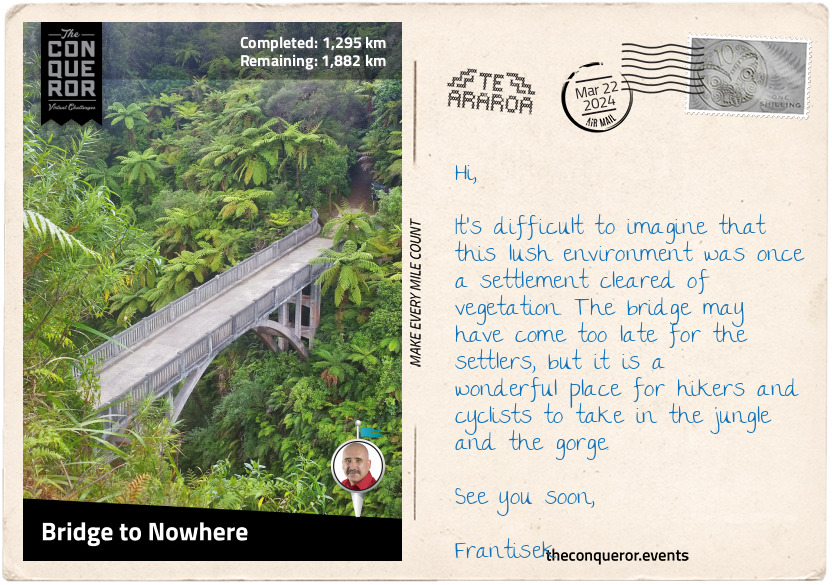
Bridge to Nowhere
Now, why would a bridge be called the Bridge to Nowhere? Usually, Bridges to Nowhere are incomplete or not connected to a road. But clearly, this one is bound to land on both sides. The simple answer is that it is a remote bridge with no road access. The only way to get to it is either hiking or cycling. Lucky for me, it's part of Te Araroa, and I get to cross it and have a great long view of the lush rainforest and Whanganui River below.
But a little digging indicates that the bridge was actually made for vehicular access. In early 1917, the government opened the Mangapura Valley and allotted land to soldiers returning from World War 1 to help them reintegrate into civilian life. Forty families travelled upriver by boat to discover a dense rainforest crowding the banks. They rolled up their sleeves and cleared 450 hectares of virgin forest. A school was set up, and farming life began. Unfortunately, the soil was not fertile, and the plants failed to grow and thrive.
The government tried to help, aware that access was difficult and the farmers often had to deal with the makeshift bridge being carried away following heavy rains and rockfall. Eventually, a road and a concrete bridge were built in 1936. Unfortunately, this was the height of the Great Depression, and its hard-to-reach location made it impossible. The farmers gave up and abandoned their farms.
A major flood sealed its fate as the government was not prepared to continue spending on road maintenance and officially closed the valley. With time, nature reclaimed the land, and all that remained was the Bridge to Nowhere.
km od začátku : 1498
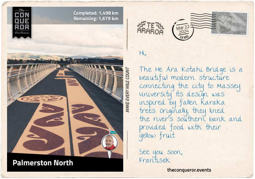
Palmerston North
Colloquially known as Palmy, the city of Palmerston North was named after Viscount Palmerston, a former British Prime Minister from the 19th century. The suffix North was added later to differentiate it from the town with the same name on the South Island.
The Manawatu River flows on the city's south side. The local council developed a 4.4mi (7km) foot and cycle track and the He Ara Kotahi Bridge to connect it to Massey University. The university is the second largest in New Zealand (excluding international students) and the only one to offer aviation and nanoscience degrees.
One of the main highlights in town is the New Zealand Rugby Museum. Established in 1970, the museum houses a comprehensive collection of rugby memorabilia and rare artifacts. It was founded by keen rugby supporter John Sinclair, who attended Nelson College, where rugby was played for the first time in New Zealand.
After seeing the New Zealand Army rugby team play in the UK at the end of WWII, Sinclair devoted himself to learning everything he could about rugby history. He then pitched the idea of a museum, and Fred Spurdle, President of the Manawatu Rugby Union, offered his assistance. Sinclair threw himself into the project and began collecting rugby objects while Spurdle meticulously documented every single one.
An inaugural display occurred in 1969 with 16 past All Blacks, national rugby team players, and the Governor General in attendance. In 1970, the first exhibition opened on the day rugby turned 100.
Sinclair and Sturdle approached Neil Monro to become the Treasurer. Accepting the job, Neil has been doing it for the last 50 years. Neil's grandfather was Charles Monro, who introduced rugby to New Zealand. Charles organized the first game between Nelson College and the Nelson Football Club. He also coached a Wellington team, played for a Nelson team, and refereed the first game on the North Island. A memorial statue of Charles was erected at the entrance of the museum.
The museum captures the essence and history of this much-loved New Zealand sport. It holds more than 40,000 items, including a 1905 All Blacks jersey, size 20 rugby boots (for real), and a stuffed kiwi that was meant to be gifted to the first team to beat them during the 1924-25 Great Britain tour. They were undefeated, and the kiwi came back home.
Pop quiz: What was the original colour of the All Blacks jersey?
km od začátku : 1601
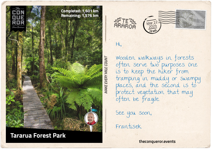
Tararua Forest Park
Heading southeast from Palmerston North, I arrived at one of the entrances into Tararua Forest Park. A protected area at the southern end of North Island, the park contains nearly three-quarters of the Tararua Range. The mountain has a northeast-southwest direction and stretches for 50mi (80km).
Its three highest peaks are Pukeamoamo/Mitre, Mount Bannister, and Mount Hector, ranging from 5016-5150ft (1529-1570m). As the range's summits are relatively uniform, it indicates that it was once part of an ancient plain that was pushed upward millions of years ago. With time the plain eroded away, leaving behind the mountains known today.
Mount Hector was named after James Hector, a Scottish geologist, naturalist, and surgeon who immigrated to New Zealand and became the chief government scientist. James was a highly accomplished person who founded the Geological Survey of New Zealand. He also advised politicians, managed the Wellington Botanic Gardens, developed the Royal Society of New Zealand, and wrote 45 scientific papers. James received several awards for his contributions, including the Order of the Golden Cross and Knight Commander of St Michael and St George. The Hector Medal and Prize were established in his honour, and it's the leading award for excellence in research.
The range has a very windy and wet climate, dumping as much as 5,000 mm of rain annually on the western slopes. Consequently, the vegetation varies. In the west, it's a combination of conifers, ferns, shrubs, and vines. In contrast, the drier east side is dominated by beech and a more open forest.
With its rugged terrain and challenging climate, the mountain range is wildly popular with trampers (hikers). The Tararua Tramping Club was established in 1919, making it the first of its kind in New Zealand. Up to 150,000 people visit the park each year.
The Tararua range was once the refuge of the now-extinct huia bird. It had the most distinct bill shape, with the female’s being long, thin, and curving downwards, while the male’s was short and stout, like a crow. They had deep-metallic, bluish-black plumage, orange wattles, and a broad white band across the tip of the tail feathers. In Māori culture, the bird was sacred, and its feathers were worn only by people of high status. The birds became extinct following significant deforestation and overhunting.
km od začátku : 1727
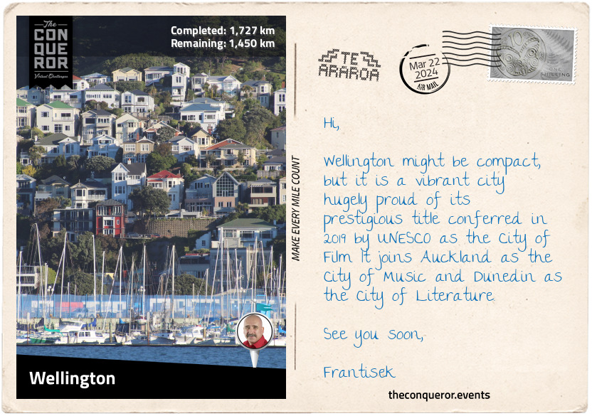
Wellington
I have finally arrived in New Zealand's capital city, Wellington. It is a compact city, bounded by hills on one side and the harbour on the other. The downtown area sits on reclaimed land, and its buildings rise like a mini-Manhattan. The city is one of the principal seaports serving domestic and international shipping, including cruise ships.
Kupe was a legendary Polynesian explorer and tribal chief from Hawaiki. Legend says he was the first human to discover New Zealand and that he stayed in Wellington's harbour around 925 AD. A statue of Kupe can be found on the waterfront. Whatonga was a later explorer who named the harbour Te Whanganui-a-Tara after his son Tara. Whatonga's descendants inhabited Wellington until 1820, when most of them were forced out by other incoming tribes. In 1839, as part of Edward Wakefield's colonisation plans (see postcard 20), his brother, William Wakefield, arrived to purchase land to sell to European settlers.
Concerned that the South Island, where the goldfields were, would choose to become a separate colony from the British Empire, the then Prime Minister proposed to shift the capital from Auckland to Wellington. Centrally located between the two islands with a good harbour, it proved to be a suitable location. Wellington's city status was raised to capital in 1865.
A challenge to living in Wellington is the frequency of seismic activity. The city rests on the point of two tectonic plates: the Australian Plate to the west and the Pacific Plate to the east. The plate movements have created three fault lines: Ohariu Fault, Wellington Fault, and Wairarapa Fault. The Wellington Fault runs through the city's centre, beginning on the floor of Cook Strait, along the western edge of the harbour, and terminating in Woodville. Because of the number of earthquakes, the city is a "leading centre for studying and researching seismic activity and strengthening techniques in buildings."
Going by several nicknames, two of the most common are "Wellywood" and "The Windy City." Wellywood is a combination of Wellington and Hollywood, referencing Peter Jackson's production company WingNut Films and the special effects and prop company WetaWorkshop. Jackson was the director of The Lord of the Rings trilogy and WetaWorkshop was the movies' set and costume designer. As for The Windy City reference, it is self-explanatory, and it's mainly due to its location on Cook Strait, where the gales blow from the north and the south.
Wellington is known for its coffee scene, having more cafes per capita than New York City. Apparently, the flat white has been perfected here. Ethnically diverse, the city is a melting pot of flavours. Imagine Malaysian rendang, Italian risotto, Korean kimchi, Samoan palusami, or the budding influence of Ethiopian migrants, such as the Doro Wat (a spicy chicken stew).
As a coffee aficionado, I am off to find a strong aromatic cuppa and reflect on my North Island experience. From here, I will board a boat and head across Cook Strait to South Island.
km od začátku : 1791
Ship Cove
Do you remember Māui's story when he reeled in a giant fish, which turned out to be North Island? The next stage of that story says that South Island was Māui's waka (canoe), and Stewart Island was the anchor.
However, on Te Waipounamu/South Island, another story is told by its principal iwi (tribe), the Ngāi Tahu. It relates to the four sons of Raki (sky father), who traveled from the heavens on their waka to meet his second wife, Papa (earth mother). Upon their return, their karakia (incantation) failed, and the waka overturned, becoming the Te Waipounamu (the South Island). Climbing atop the waka, they waited for help that never came and eventually turned to stone, becoming the mountains of the Southern Alps. The highest peak is said to represent the eldest son Aoraki, hence the mountain's name, Aoraki/Mount Cook.
South Island is 32% larger than North Island, yet it contains only a quarter of New Zealand's population. It is a spectacular mountainous island with hundreds of lakes, glaciers, fiords, and national parks. Many are included within the World Heritage site, Te Wāhipounamu - South West New Zealand, which I will cover when I get to Mavora Forest.
The Southern Alps stretch along the length of the South Island, dividing the Canterbury Plains to the east from the rugged coastline of the West Coast. It contains 18 peaks over 9800ft (3000m) and over 3000 glaciers over one hectare.
Eight of the ten largest lakes in New Zealand are in the South Island, with Lake Wakatipu in Queenstown as the largest on the Te Araroa route. The trail passes several other large lakes, including Wānaka, Hāwea, Pukaki, and Tekapo.
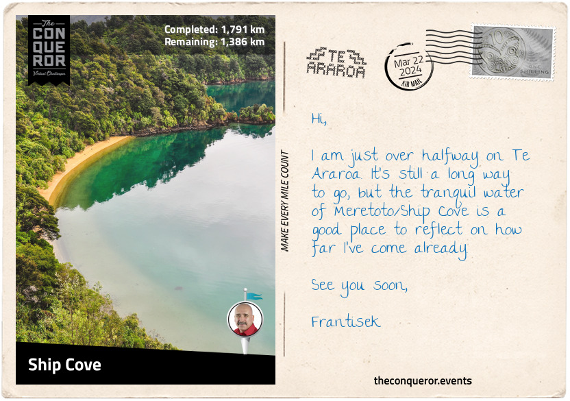
Having arrived by boat in Meretoto/Ship Cove, I disembarked on a jetty and walked up the beach to Captain Cook's Monument. The raised monument signifies the day in 1770 that Cook, in the presence of the island's Māori Chief, raised the flag, claiming British sovereignty over South Island.
The cove is surrounded by lush forest, with the taller trees over 200 years old. They were probably growing when Cook was here. He must have loved this place as he spent a lot of time here every time he sailed these waters. In a more practical sense, he probably chose this location because it was accessible to open water, sheltered, and could stock his provisions.
On the eastern shore of the cove is Tōtarunui/Queen Charlotte's Sound. The Sound is home to a pod of Hector's dolphins. Endemic to New Zealand, they are the smallest and rarest dolphins in the world. Hector dolphins have a distinctive black facial marking, a short, stocky body, and a dorsal fin that resembles Mickey Mouse's ear. It was named after Sir James Hector, the 19th century Colonial Museum curator in Wellington (now the national museum). The dolphin is currently listed as an endangered species.
km od začátku : 1897
Pelorus Bridge
Heading southwest on the Queen Charlotte track, I skirted around the hilltops to Punga Cove. I ascended to the ridge on what would be a long and narrow landform with several bays and inlets butting up against it to the south and the Kenepuru Sound to the north.
The narrow track was well-graded, passing through a sub-tropical rainforest of beech, kamahi, and giant rimu trees. Native ferns, including the iconic silver fern, covered the understory. The silver fern is a widely recognised symbol and the country's national plant.
Stylised versions of the silver fern can be found on several sports teams, such as the All Blacks jersey, the tail end of Air New Zealand planes, and the coat of arms. Koru is the spiral shape based on the unfurling of a silver fern frond symbolising "new life, growth, strength, and peace." It is often seen in Māori art, carving, and tattooing. A Māori legend says that the "silver fern once lived in the sea, and the Māori hunters would use the silver underside of the fern leaves to find their way home. When bent at an angle, the leaves of the fern would catch the moonlight and illuminate a path through the forest."
Beautiful views of the bays, inlets, and sound appeared intermittently. At Onahau Bay, the trail began its descent and ended in Anakiwa, a small coastal village. After a brief rest and refreshment, I connected to another trail and continued to Havelock.
Havelock is a small town that "promotes itself as the green shell mussel capital of the world." During the gold rush of the 19th century, Havelock was a thriving town, with the nearby Wakamarina Valley proclaimed a goldfield. As the rush subsided, sawmilling became the town's economic activity, followed by dairy farming. Today, many of the valleys around town are pine plantations.
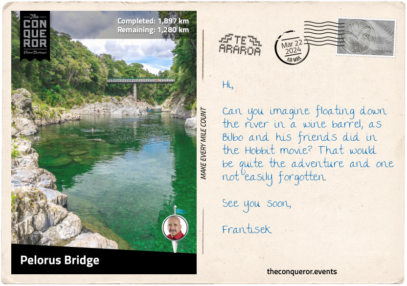
Pressing on, I passed Canvastown, another town that expanded during the gold rush and contracted when the gold ran out. My next stop was Pelorus Bridge, a small locality with the most important thing – a café.
Once caffeinated, I turned my attention to the glassy green Pelorus River, one of the filming locations for The Hobbit: The Desolation of Smaug. Fans of The Hobbit may remember Bilbo Baggins and the dwarves' exciting wine-barrel getaway from Thranduil's realm. Besides an enormous amount of computer graphics and green-screen shoots plunging down the river, live shoots were also taken on the beautiful Pelorus River with its dramatic rock walls and forest canopies.
While a wine-barrel adventure could be exciting, paddling a kayak down the river may be a more practical option. The trip will surely be more relaxing and less action-packed than Bilbo's adventure.
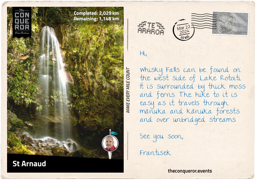
km od začátku : 2029
St Arnaud
Luckily, I managed to stay in the kayak and not tip over into the Te Hoiere/Pelorus River. After an enjoyable paddle on the river, I returned to the trail again and continued my journey.
In Māori, the Pelorus River is called Te Hoiere, named after the first canoe to travel to South Island. Ngati Kuia tells the story of Matua Hautere, one of Kupe's descendants, sailing aboard the waka (canoe) Te Hoiere and reaching Te Waipounamu (South Island). Geographically, Te Hoiere/Pelorus River is the largest river in the northwest Marlborough region flowing eastward 25mi (40km) into Te Hoiere/Pelarus Sound.
Hiking alongside Te Hoiere/Pelorus River, I crossed a swinging suspension bridge and entered Mount Richmond Forest Park, the second largest forest park in New Zealand. The track was easygoing, with a few protruding roots I had to climb over. After a few miles, I took a side track down to the Emerald Pool. The colour was a brilliant deep, transparent green enticing me to take a quick dip.
After another 6mi (10km), the river and I parted ways. I zig-zagged through a big red beech forest to the Rocks Hut Overlook for a stunning 360 degrees panoramic view of the backcountry and the peak of Mount Richmond.
The trail went on through the Forest Park, sometimes on the ridge for several miles, sometimes descending into the forest, then at other times up on rocky summits, until I arrived in St Arnaud.
Previously known as Rotoiti, St Arnaud was a small alpine village on Lake Rotoiti's northern edge, serving hikers, skiers, and a hundred-odd locals. The lake was initially named Lake Arthur after Edward Wakefield's brother, but the name didn't stick and it reverted to its Māori name Rotoiti.
Arthur was a captain in the Royal Navy and later part of the New Zealand Company. His brother Edward tasked him with establishing a new settlement named Nelson. Today, Nelson is the oldest city on South Island and the second oldest in New Zealand. Located on the shores of Tasman Bay, the city thrives in the local art and crafts scene.
Rotoiti Lake borders the Nelson Lakes National Park, which I will be hiking through for the next 65mi (104km).
km od začátku : 2078
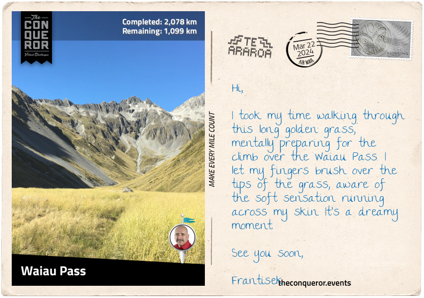
Waiau Pass
I had a pleasant 6mi (10km) walk beside Lake Rotoiti, part of it on a narrow boardwalk that protects the vegetation. Before long, the trail widened in the forest with occasional sneak peeks of the lake. The trees were beautifully tall and thin, with the blue sky contrasting the green canopies.
Travers River, which feeds into Lake Rotoiti, became my companion as I hiked through the deep Travers Valley. East of the river was Saint Arnaud Range, marking the boundary of Nelson Lakes National Park. The range is covered in beech forest at the lower elevation, while the peaks are snow-capped. West of the river is Travers Range, with Mount Travers as the highest peak at 7670ft (2338m).
At the end of the valley, I had a 980ft (300m) climb up to Travers Saddle and descended into Sabine Valley next to Sabine River. Following the river in a narrower valley, with Franklin Ridge on one side and Mahanga Range on the other, I reached Waiau Pass, the second-highest point on Te Araroa.
The hike up to the pass was strenuous. The track was rough and rocky, with steep descents in some places. Adding to the challenge was climbing up the side of scree slopes in an exposed and windy environment. Yet, the beauty of this track was seeing the stunning sapphire blue Rotopohueroa/Lake Constance surrounded by rocky mountains and jagged cliffs. Lying in a post-glacial basin, the lake is 1.2mi (2km) long and nearly half a mile (700m) wide. At an elevation of 4390ft (1340m), it is the largest alpine lake in NZ.
However, once at the top of the pass, I realised I had the same challenge climbing down. Rocky terrain, more scree, and a desolate mountainous appearance. I knew it would be tough on the knees and had to be careful not to twist an ankle, but I forged on slowly, one step at a time until I reached the bottom and found myself in another valley.
km od začátku : 2261
Arthur's Pass
And so the journey continued through another valley, with Spenser Mountains and St. James Range as my guardians and the Waiau Uwha River as my companion. For a good 15mi (25km), I walked on the St. James Walkway, past St. James Conservation Area. The conservation area was a sheep and cattle station for most of the 20th century. The government purchased the property in 2008 to protect the area from intensive farming and ensure public access.
Near Philosopher's Knob, I swung west to climb over Anne Saddle and arrived at Boyle Village, at the confluence of Boyle and Nina Rivers. Weaving south, I crossed a swing bridge over Boyle River, walked into Hope Valley, and then through the woods. Every now and then, there would be an opening between the trees where I could get a few peeks of Lake Sumner.
The trail entered the Hurunui Valley, where I crossed another swing bridge to the south side of the Hurunui River. After a few stream crossings, I arrived at a three-wire bridge at Cameron Stream that stopped me in my tracks. Imagine my surprise when all I saw was a contraption made of a few steel wires with struts. It was like walking on a slackline with wire handles and was meant to be the safer option than fording the stream. Each time I moved, the line wobbled, threatening to throw me off balance and toss me into the stream below. Each step I took was at a 45-degree angle, kind of duck-like, wedging my heel into the wire, and at each strut, I had to raise my leg high and over it to avoid tripping on the tight V-shape at the base. Historically, these wire bridges, or walkwire as they are called on topographic maps, were a financially economical way to provide a safe crossing over streams or creeks. Many have been replaced, but a few, such as this one, remain.
Getting to Harpers Pass was reasonably straightforward, but once on top, I had a 980ft (300m) descent into Taramakau Valley. I crossed another long swing bridge over the Taramakau River and scrambled over gravel rockslides. The valley then opened out for an easier walk through shrubland. Harper Pass was a heavily used crossing during the early days of the gold rush era (1864).
To the Māori, the pass was an important route across the Southern Alps to obtain pounamu, a hard stone with a jade-like colour that was fashioned into tools, weapons, and jewellery. The pounamu, found only in New Zealand, is highly valued and used for carvings. Considered a sacred stone, it was cherished for its beauty and strength. Chiefs would carry a pounamu weapon as a symbol of their status.
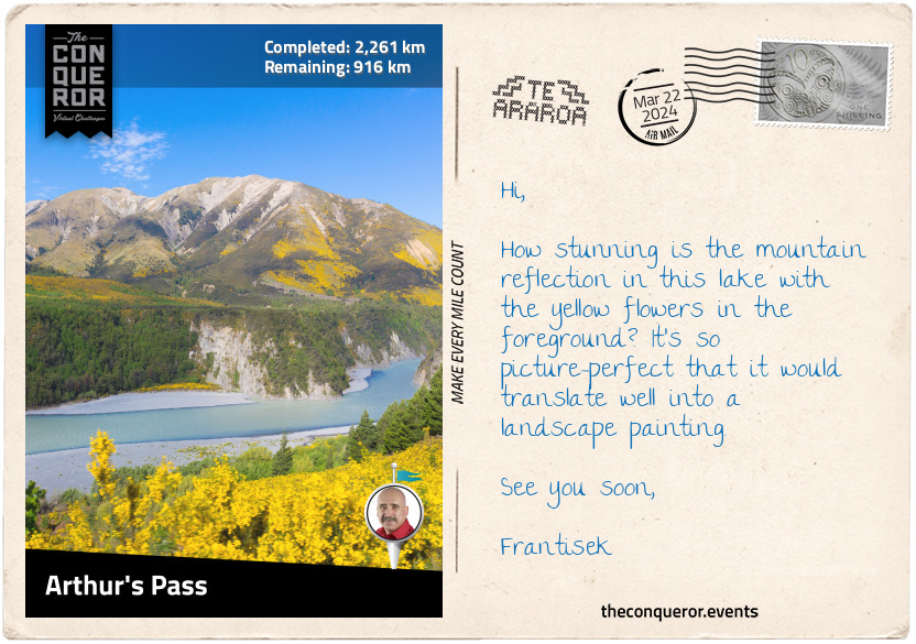
A spread of bright orange lichen called Xanthoria elegans covered rocks beside the river, providing a wonderful contrast to the surrounding greenery. Stepping into Deception Valley, I hiked over Goat Pass and followed the Mingha River to Arthur's Pass Lookout over the Waimakariri River.
Arthur's Pass is the lowest of the three alpine passes that connect the east coast to the west coast by road. It was named after Arthur Dudley Dobson, a surveyor who pioneered the route in 1864. Arthur's Pass was a more direct route than Harper's Pass. Once it was upgraded for coach traffic, Harper's Pass fell into disuse. A memorial dedicated to Doyle was erected further up Hwy 73 past Arthur's Pass village.
km od začátku : 2325
Lake Coleridge
From Arthur's Pass, I hiked beside Hwy 73 and a railway track (an alternative way to experience the pass) to Cora Lynn Hill. I entered the woods, climbed for a few miles, and exited on the north side of Mount Bruce. The trail skirted around the peak up to Lagoon Saddle, where it descended through more forest hiking alongside Harper River. Up and down I walked through Craigieburn Forest Park.
The trail wasn't too strenuous, leaving me free to enjoy the beech trees and look for the green mistletoe called pikirangi that grows on it. Legend says the pikirangi was the last plant in Tāne's (the god of forests) basket. Looking at it fondly, he decided he did not want it lying on the ground and placed it in the trees close to the sky.
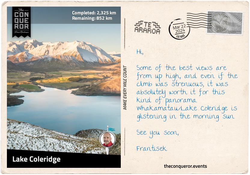
Adjacent to the scree-covered Mount Olympus are a series of rock pinnacles formed millions of years ago when rainwater washed away the exposed soil. With pointed tips, the pinnacles rise from scrubland, seeming alien and unnatural in this environment. For a moment, I drift off into a barren wasteland where only the pinnacles exist, waiting for an extraterrestrial encounter.
Various sci-fi scenes played out in my head as I forged on and arrived at Whakamatu/Lake Coleridge. This long and narrow lake is one of the top 20 largest lakes. It is beautifully surrounded by hills and snow-capped mountains.
The lake was an ideal location for New Zealand's first hydropower plant. After three years of construction, it opened for operation in 1914. A small village sprung up around the power station to house the construction workers. As they moved on, the plant's staff members and their families moved in. Harry Hart was one of the superintendents. He had a keen interest in exotic trees and planted many different species. Harry was curious to learn which ones did well in New Zealand. The collection grew so much that it was classified as an arboretum. Today, it is open to the public as the Hart Arboretum Tree Trail. Some of the more interesting ones are the Western Hemlock with its distinctive droopy branches; the European Silver Fir with its gorgeous cylindrical-shaped cones; and the Mexican White Pine, known to have some of the longest cones.
km od začátku : 2475
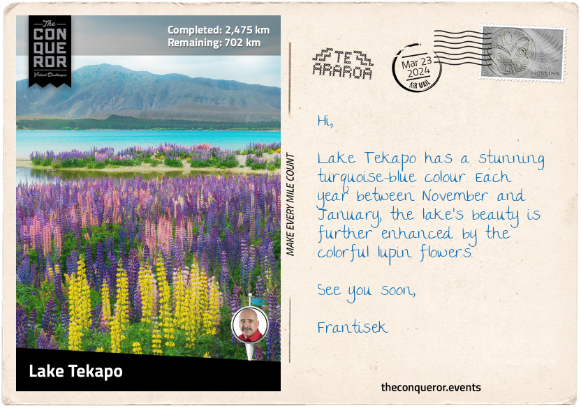
Lake Tekapo
I have moved into tussock country, home to wide open plains within mountainous regions. The grassy landscape contrasted with the forested areas I experienced further north.
There are two perilous river crossings in this section. The first is over the Rakaia River, one of the largest braided rivers in the country. Rising in the Southern Alps, it travels 93mi (150km) through a wide shingle bed and flows into the Pacific Ocean. As a glacially fed river, its northwest rainfall causes regular floods in spring and summer. So even if the plains are dry, the river level can be high. There's no safe way to cross the river, although some trampers have found ways further upstream. The safer option is to organise a ride and travel via the nearest road.
The second crossing was the Rangitata River from the Potts River tributary. While tricky, it was possible as the water flow was low. Rangitata is another braided river that flows east for 75mi (120km) and empties into the Pacific Ocean. A bit further north of the river is Mount Sunday, the photography location for Edoras, the capital of Rohan in Lord of the Rings.
Continuing on, I climbed up to Crooked Spur, descended a bit, then up again past Royal Hut, named after King Charles's brief helicopter ride. A further 3mi (5km) and I reached Stag Saddle, the highest point on Te Araroa. A small black and yellow sign marked the location. I had the most remarkable sweeping views as far as Aoraki/Mount Cook, New Zealand's tallest mountain.
The remaining miles were a descent to Lake Tekapo and the town on its southern shores. The lake is on the northern edge of Mackenzie Basin, historically known for sheep farming.
A humorous story is told of James Mackenzie, a Scottish immigrant, after which the basin was named, who drove 1,000 head of sheep across this area. The trouble was that none of the sheep were his. He had stolen all of them. James managed to escape his accusers and walk for 100mi (160km) before he was caught by the police. Sentenced to five years of hard labour, James just couldn't handle being in jail. He escaped twice before being placed in irons. Nine months later, he was pardoned when serious flaws in the investigation were discovered. He sailed to Australia shortly after his release and was never heard from again.
Taking a leisurely stroll around town, I stopped by the Sheepdog Memorial, which paid tribute to working dogs. Then I walked to the lake's edge and joined a bunch of kids skimming stones.
km od začátku : 2696
Wānaka
New Zealand is a country of lakes. There are over 3800 lakes between the two islands, with the majority on the South Island. Carved by glaciers, the lakes are pristine and beautiful, with the bluest colour imaginable.
I was immensely delighted to travel through this section as I passed lake after lake. The first was the milky blue Lake Pukaki, the 7th largest lake. You have to see that colour. I walked down its western side along a trail shared with the Alps to Ocean challenge. Lake Pukaki is part of the Waitaki hydroelectricity. Its southern end used to have an outflow into Lake Benmore but has been dammed.
Near the lake's power station is a wonderful view across the lake all the way to Aoraki/Mount Cook. I could just make out its peak. A bronze statue of a Himalayan Tahr stands on a boulder here. In the early 1900s, a dozen tahrs were introduced in New Zealand, hoping to increase tourism. The population steadily grew; by the 1970s, more than 40,000 tahrs existed. Overgrazing was having a devastating effect on the landscape, and a culling program was introduced, limiting the numbers to 10,000 animals. Today, the Himalayan tahr is listed as a vulnerable species. Outside of their native India and Nepal, New Zealand is the only country with a significant herd.
Heading south, I travelled through the small town of Twizel. It was built in the late 1960s to house construction workers on the Upper Waitaki hydro scheme. In the centre of town are two statues of black stilts, kakī in Māori. They are wading birds found only in New Zealand. Incredibly rare, they are critically endangered, with less than 170 adults surviving in the wild. These black-plumed birds, with long pink legs and a long black beak, breed in the Mackenzie Basin. Twizel has a facility where a captive population of kakī is maintained for breeding. Juvenile birds are then released into the wild. The nearby Lake Ruataniwha is used for watersport activities. It is an artificial lake formed in the late 1970s as part of the hydro scheme.
Next is Lake Ōhau. Māori legend tells the story of Rākaihautū, an early Polynesian explorer who arrived in Nelson, South Island, possibly around the 9th century with his wife and son. Rākaihautū travelled with his wife through Te Wai Pounamu and, with his kō (digging stick), Tūwhakarōria, he dug up many of the South Island's freshwater lakes, including Lake Ōhau.
Lake Ōhau is known for its peacefulness and stargazing. In 2012, a significantly sized area on the eastern shores of the lake was declared Aoraki Mackenzie Dark Sky Reserve. The reserve's unpolluted sky makes it an astrophotographer's dream location.
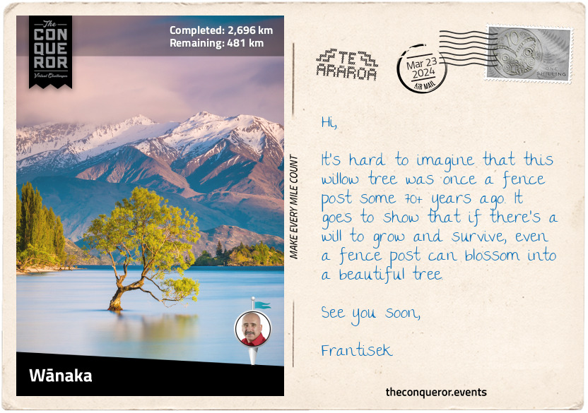
Lake Hāwea and Lake Wānaka are two parallel lakes running north-south. Lake Hāwea is the 9th largest lake and has had three Royal New Zealand Navy ships named after it, with HMNZS Hāwea still in active service.
Lake Wānaka is the 4th largest lake, with a town on its southern shore. Lake Wānaka is one of the few remaining lakes whose shores have remained unmodified. Many others throughout the country were affected when hydroelectric dams were constructed to manage the electricity shortage after WW2.
A quirky tourist attraction is 'That Wānaka Tree,' a willow tree found sitting in the lake. It's a photogenic tree that is easily accessible to any photographer who wants to capture its gorgeous curves with a fabulous mountainous background.
km od začátku : 2789
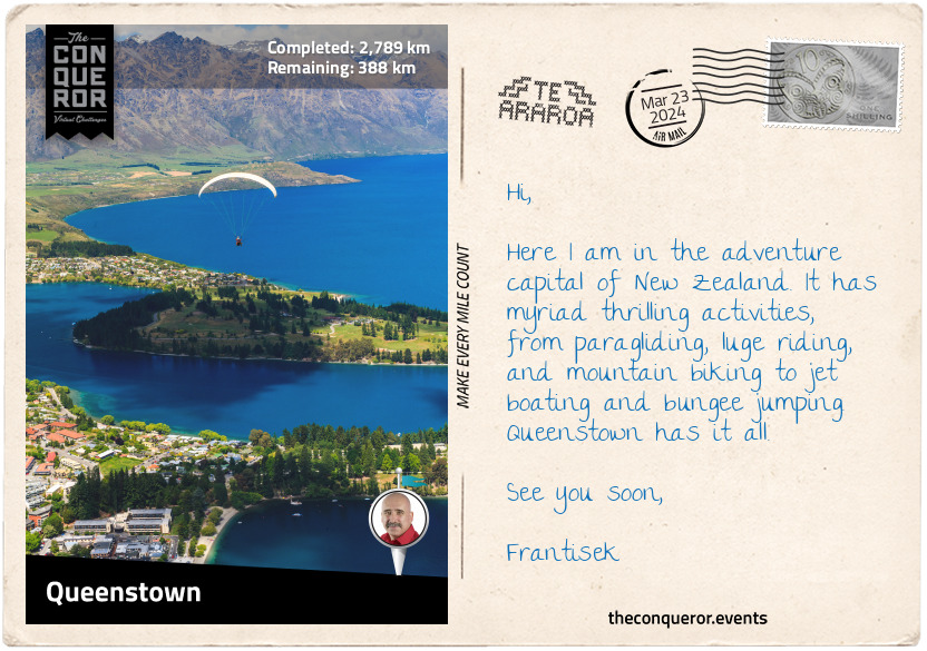
Queenstown
Queenstown has to be the adventure capital of New Zealand with its year-round high-octane sports. Let me begin with the Kawarau Gorge Suspension Bridge. It was built in 1880 to provide access to the goldfields. A century later, entrepreneur AJ Hackett launched a bungee jumping site at the bridge. Imagine standing on the edge of a platform with a stretchy elastic cord tied around your ankles and then willingly throwing yourself off to free-fall 154ft (47m). A most exhilarating experience.
But let's turn it up a notch and take a relaxing cable car ride to Bob's Peak for a paragliding experience. You wander over to an angled grassy field where a guide lays out a particular type of parachute. He then clips you into a harness and attaches himself to you. Instructions are coming in fast, and while still mentally processing, you're told to start running. Before it all sinks in, you suddenly drift over Queenstown, 2600ft (800m) above sea level. There is no turning back, and all you can do is enjoy the stunning views of Lake Wakatipu, the 3rd largest lake, and its surrounding peaks. But for extra excitement, the guide creates a G-Force experience by adding some speed to the descent with a handful of sharp turns. It can play a little havoc on the stomach.
However, for those who want to keep their feet on the ground, there are several stunning hikes or strolls along the lake's shores. In winter, the town becomes the centre of all snow sports activities.
Movie fans could head out to Deer Park Heights, a working farm, to explore the filming locations for The Lord of the Rings, Wolverine, Disney's The Rescue, and Pete's Dragon. Along the way, you may encounter any number of animals, including red deer, Himalayan tahr, highland cattle, llamas, and alpacas. The farm is 1800ft (550m) above Queenstown, overlooking the town and Lake Wakatipu.
There is definitely lots to do and see. Then there are all the restaurants, more than 100, with an endless supply of delicious choices. How do I even begin to choose?
km od začátku : 2932
Snowdon State Forest
Leaving Queenstown behind, I had the most beautiful walk beside the magnificent S-shaped Lake Wakatipu, past Glenorchy, and all the way to Isengard Lookout in Dart Valley. It is hard not to continuously reference The Lord of the Rings. The director, Peter Jackson, knew that the raw beauty of New Zealand was the perfect landscape for his trilogy, and he showcased it every chance he got. Here Dart Valley was the backdrop for the Wizards Vale and the location of the fortress Isengard.
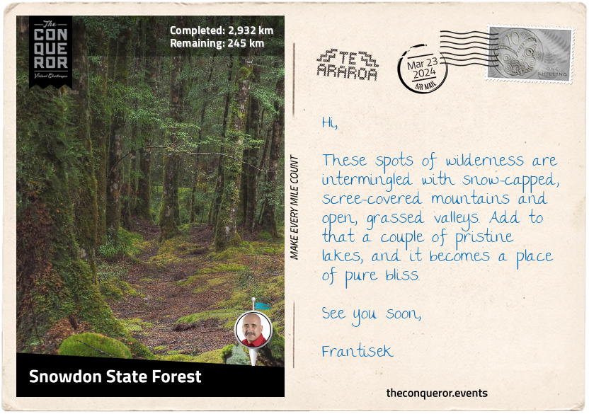
From the lookout, I crossed the single-lane bridge over Dart River and hiked south on the opposite side of Lake Wakatipu. At Elfin Bay, I connected with Greenstone Track, then Lake Rere track, both part of Te Araroa, and continued through large areas of tussock grassland, over Mavora-Greenstone Saddle, and into Mavora Lakes Conservation Park. The park is located within the Snowdon State Forest and is known for its two lakes: North and South Mavora. It is fringed with forest and towered by the Livingstone Mountains to the west and Thomson Mountains to the east.
With its two lakes and beech forestry, the park is part of the Te Wāhipounamu World Heritage Area, a massive 10,000sq mi (26,000sq km) site. In Māori, Te Wāhipounamu means the place of greenstone (pounamu). This incredible site contains iconic national parks such as Aoraki/Mount Cook and Fiordland, active glaciers such as Franz Josef Glacier and Fox Glacier, and numerous peaks, lakes, waterfalls, fiords, and valleys.
A Māori legend tells the story of Hinehukatere, a strong, fearless girl who loved mountaineering. One day she invited her love interest Wawe to join her on a climb. Wawe was less experienced, and trying to keep up with her, he lost his footing and fell to his death, or as told in another story, he was caught in an avalanche. Hinehukatere was heartbroken and cried endless tears that froze to form the Franz Josef Glacier. In Māori, it is called Ka Roimata o Hinehukatere, which means the tears of Hinehukatere.
What makes Te Wāhipounamu so unique is its flora and fauna. As the country's most extensive and least modified area, the vegetation here is in pristine condition. It is considered the best modern representation of the original flora of Gondwana. Many indigenous animals live here, including the Southern Brown Kiwi, Yellow-crowned Parakeet, New Zealand Falcon, and Takahe, found in a few areas in Fiordland.
My favourite bird, though, has to be the kea. It's a large parrot species with olive-green plumage and a brilliant orange colour under its wings. They are intelligent, cheeky, and playful. One humorous story was about a driver who left his vehicle with the window slightly open. A kea squeezed itself in the car, picked up a stack of postcards, and squeezed out. Imagine the driver's surprise when he found a kea with a mouthful of his postcards. Of course, a bit of a tussle ensued until the kea released the goods. Moral of the story? Keep your car windows closed. Watch their playfulness with a hidden camera in a snowball: https://youtu.be/n9iifaLV15Q
km od začátku : 2993
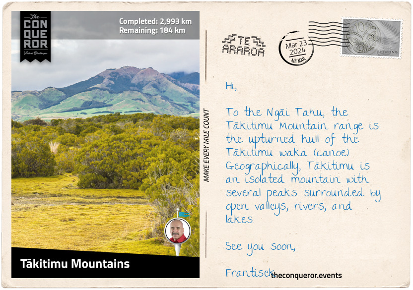
Tākitimu Mountains
Surrounded by pastures, farmland, and tussock grasslands are the Tākitimu Mountains and the scree-covered Brunel Peaks. Te Araroa travels along its eastern face through beech forest and over river valleys.
Tākitimu Mountains are an important place to the Ngāi Tahu, to whom the mountain represents the upturned hull of the Tākitimu waka (canoe). The Tākitimu was one of seven great migration wakas. It was a large twin-hulled ocean-going canoe. As such only selected chiefs, the holders of its people's histories and knowledge, and sacred relics were permitted to sail.
Tamatea-Arikunui was a high priest who ordered the making of Tākitimu. Construction was closely guarded, and common people were not permitted to enter. Only the craftsmen were allowed under tapu, a concept best described as a spiritual restriction. When the canoe was complete, the tapu was lifted by special rites. Consecration of the canoe followed, seeking blessings from Tangaroa, the god of the sea and sky, for safe passage and Tāne, the god of the forest, whose timber was used to build the waka.
Launching on its voyage, Tākitimu made landfall near Ninety Mile Beach, North Island. Navigating around the North Cape, past Cape Reinga, Tākitimu sailed down the east coast to Tauranga, where Tamatea disembarked and handed the waka to be captained by Tahu.
In search of pounamu, Tahu continued to the South Island by navigating along the west coast to the Arahura River, north of Hokitika. Now, here the story loses its thread, and I'm not quite sure what happened, except that Tahu became the ancestor of the Ngāi Tahu iwi.
According to one legend, Tākitimu, captained by Tamatea, was wrecked in Te Waewae Bay and the hull was "hurled inland by giant waves," becoming the Tākitimu Mountains. And here the confusion lies since Tamatea never travelled beyond the North Island. However, it is entirely possible that the Tamatea and Tākitimu that the legend refers to are actually about the grandson Tamatea-Ure-haea, who built a canoe and named it the same in memory of his grandfather. Tamatea-Ure-haea was an explorer and is said to have circumnavigated the North and South Islands. His journey has him travelling the east coast of South Island, then westward, where he possibly wrecked the waka that became the Tākitimu Mountains. Some say that he built a new waka to complete his journey.
It is impossible not to get drawn into the wonderful world of Māori storytelling. Passed down through generations, the stories touch on many areas of history, culture, and society. They are a blend of myth and truth, and their many heroes often inspire a model of behaviour to strive for and overcome difficult times. My growing familiarity with the many characters I was introduced to through these writings has broadened the way I see Aotearoa/New Zealand. Through the eyes of these legendary figures, every lake, mountain, and valley takes on a new meaning.
km od začátku : 3148
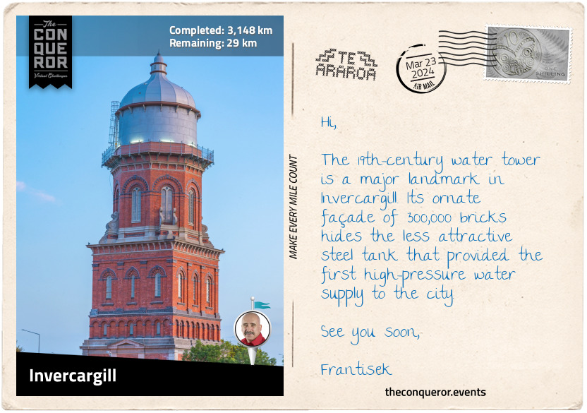
Invercargill
I hiked right through the middle of Longwood Forest, made up of beech and podocarp trees. The hilltops are large expanses of tussock grasslands. The Round Hill Conservation Area at the south end of the forest is a popular red deer hunting area.
For the next 22mi (35km), I walked on the shores of Colac Bay and Oreti Beach. Foveaux Strait, which includes the two bays, Te Waewae Bay and Toetoes Bay, stretches for 80mi (130km), separating Stewart Island from South Island. The Strait lies within New Zealand's continental shelf and is thought to have been dry land during the Pleistocene era.
Stewart Island is New Zealand's third largest island and, in mythology, is believed to represent Māui's anchor. The island was named after William W. Stewart, a Scottish sealer and the first officer on the ship Pegasus. Stewart charted the southeastern harbour of the island and determined its northern point, confirming that it was indeed an island. The harbour, Port Pegasus, was named after Stewart's ship.
Leaving the beach, I trekked inland and skirted around the edge of Invercargill. Founded in 1856, Invercargill is the southernmost and westernmost city in New Zealand. The almost grid-like city plan and extra wide streets are the foresight of John Turnbull Thomson. He was a 19th-century British civil engineer who was "instrumental in the development of early infrastructure in Singapore and later in New Zealand." Many of Invercargill's streets bear the names of Scottish rivers, i.e., Dee, Tweed, Ness, Ythan, and Clyde, a reflection of Thomson's Northumbrian background.
With just a little further to go, I am nearly at the end. One last final push.
km od začátku : 3177
Bluff
Bluff is one of the oldest European settlements in New Zealand. It was founded in 1823 by James Spencer, who established a trading post to supply visiting ships. The settlement went by many names, including Campbelltown, but the locals insisted on calling it Bluff, and in 1917, the name was officially recognised.
With a natural harbour, Bluff’s history is steeped in whaling, sealing, and shipping. Today, it has a large seaport mainly for commercial ships and fishing boats. Before the town’s entrance is a lovely coastal walk track with views across the harbour and Tikore Island.
Bluff sits on the eastern edge of a peninsula, and at the centre dominating the rest of the area is Bluff Hill, with a lookout on top. The Bluff Maritime Museum tells the story of its heritage. Its biggest attraction is a beautifully restored oyster fishing boat from the early 20th century. Named Monica II, the boat was donated as a permanent display in 1998.
A must do was a walk to Stirling Point, where the famous yellow signpost gives directions to twelve locations worldwide. Nearby was a massive chain sculpture called Te Puka a Maui (Maui’s anchor). It symbolises the Māori belief that Rakiura/Stewart Island is anchored to Te Waka a Maui (Maui’s canoe)/South Island. A similar sculpture on Rakiura/Stewart Island represents the other end of the chain. One could imagine this grand chain disappearing beneath Foveaux Strait, keeping the island spiritually and physically connected to the mainland.
Having reached the tail end of Te Araroa, I am in awe at all the beauty New Zealand has to offer. Between striking landscapes, modern cities, legendary warriors, and sacred places, this long journey opened my mind and heart and awakened my spirit.
Farewell till the next time.
km od začátku : 3195
Whanganui
Edward Gibbon Wakefield was a British diplomatic courier (King's Messenger) in the early 1800s with grand political aspirations. When his wealthy wife died in childbirth, he concocted a plan to kidnap a young socialite and marry her for her wealth in the hope he could enter Parliament. Tying the knot in Scotland, he led her through the countryside and onto France under false pretenses. His wife's uncle and local police were hot on his trail. Wakefield was arrested and imprisoned for three years.
Imprisonment did not deter Wakefield from grand dreams. Soon after his release, he became widely interested in colonial affairs and an early leader of New Zealand's colonisation. Becoming director of the newly founded New Zealand Company, a British charter, Wakefield set the colonisation of New Zealand in motion. The Company's first established settlement was Wellington, followed by Whanganui – both in 1840.
The ancestral home of many Whanganui tribes, the city is located on the western coast of North Island, with the Whanganui River flowing through it. When Wakefield purchased land to settle the area, he named it Petre after Lord Petre, one of the Company's directors. But the settlement was wrought with problems, as the land was haphazardly purchased from the Māori, and new settlers were occupying lands still claimed by the Māori. It would take eight years before some agreements were reached, although undercurrents of tension continue to exist today.
Whanganui has a wonderfully diverse architectural style. Walking through its streets, I appreciated the 1960-built, modernist-style War Memorial Centre. The centre won a gold medal from the New Zealand Institute of Architects and is listed in the top 50 modernist buildings in the southern hemisphere.
The Sargeant Gallery has a robust neo-classical style, while the nearby cinema is beautifully preserved with its original Art Deco lines. At the centre of the main street is the Watt Fountain, built in 1906 as a memorial to the town's first mayor William Hogg Watt. The gorgeous Royal Opera House is the last Victorian theatre in the country. Made from wood and erected in 1899, the theatre seats 890 people and continues to be in use today. In 1999, as part of its centennial celebrations, the building was bestowed with a Royal charter and renamed the Royal Whanganui Opera House.
With plenty more to see, I visited the two large towers – War Memorial and Water Towers - overlooking the town, each with its distinctive architectural style. Another unique landmark is the "Handspan Peace Sculpture", a double-spiral path converging at the centre covered in 4000 clay casts of hands. It was unveiled in 2002 as part of the 20th Anniversary International Day of Peace celebrations.
Whanganui is a beautiful place worthy of a lengthy exploration. Better yet, I may just hop on the Waimarie Paddle Steamer and cruise down the river for a relaxed view of the city.