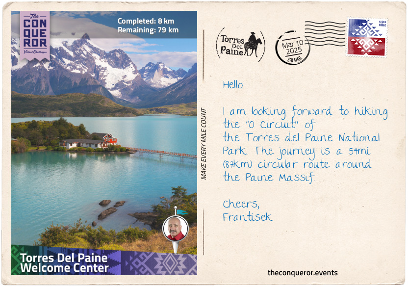
At the southern end of Chile on the continent of South America is the exquisitely pristine mountainous terrain of Torres del Paine National Park. Established in 1959, the park is filled with tall peaks, ample glaciers, turquoise lakes, rivers, plenty of wildlife and hundreds of species of flora. In 1978 the park was designated a UNESCO Biosphere Reserve.
The name Torres del Paine translates as The Blue Towers, and it refers to the three famed granite towers that the park is named after. Located within the Paine Massif (aka Cordillera del Paine), The Towers are amongst a dozen or so other significant peaks within the mountain formation ranging from 6,560ft (2,000m) to 9,462ft (2,884m) in elevation.
The park and its two major trekking circuits are very popular with hikers. The "W Circuit" is the shorter route that as the name suggests travels in a "W" shape through two of the four valleys and beside Grey Lake close to Grey Glacier.
The "O Circuit" is a hiking trail around the entire massif, past several lakes, rivers and glaciers. The circuit was pioneered in 1976 by John Gardner with two local rangers when they successfully circumnavigated the massif. This is the journey I will be undertaking.
Beginning at the Welcome Center on the southeast corner of the massif, my journey will be heading anticlockwise, hiking north on the east side of the mountain. Following the river to Los Perros Glacier, I climb over John Gardner Pass and cross several suspension bridges. Once beside Grey Glacier, I will keep skirting around the mountain alongside Grey Lake on the westside, then Nordernskjold Lake on the southside and finish back where I started.
I anticipate gusty winds, shifting weather patterns and some tough trekking sections. Whilst I'll be happy to see a herd of guanacos on my travels, any puma sightings would be preferred from a distance.
Time to hit the trail.
km od začátku : 0031
Lake Dickson
I left the Welcome Center hiking northbound on the east side of the massif. The trail followed parallel to the Paine River on the outskirts of the vast Patagonian Steppe. The environment was harsh with strong winds sweeping across the plains.
Most of the vegetation consists of desert shrubs and tuft grasses but even these are not without interest. Shrubs such as the Mata Verde produce white flowers with antiseptic properties that were once used for medicinal purposes. The Guanaco Bush sprouts with bright red-orange flowers and is one of the first bushes to bloom. Another unique looking plant is the Capachito or otherwise known as Lady's Slipper because the small yellow flower with reddish-brown edges is in the shape of a slipper.
The Steppe is also home to the native guanaco. Roaming on the plains in herds, the guanaco is a camelid and closely related to the llama. Young guanacos called chulengos are capable of walking shortly after birth and able to keep up with the herd right away. This is a necessary adaptation given that in the open plain guanacos have nowhere to hide and pumas are their natural predators.
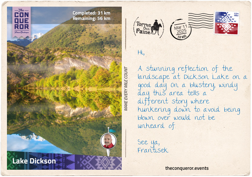
Ten miles (16km) into my trek I turned the corner of the massif at Paine Lake and entered Dickson Valley. I travelled adjacent to Paine River on a flattish trail with views of Cerro Escudo and Cerro Cabeza Del Indio, both mountains on the northern portion of the massif.
This section of my journey finished at Dickson Lake, the source of Paine River. Interestingly this lake used to be solely within Chile's territory with Dickson Glacier at the head of it. Because the glacier retreated significantly, it opened the way for Dickson Lake to join with newly formed lakes from Argentina's side. Today, it is an international lake with parts of it within both countries.
km od začátku : 0052
Grey Glacier
I left Dickson Lake and followed the Los Perros River toward Los Perros Glacier. The trail meandered through beautiful old beech forests with occasional views of the mountains beyond. The river flowed swiftly, tumbling over its rocky bed. It was a welcome change from the wide-open terrain of the Steppe where the force of the wind can reach 100mph (160km/h) and literally knock hikers off their feet. With no landmasses to break the winds, the Patagonian Steppe is open season for strong gusty winds.
Sheltered amongst the forests, I enjoyed the peacefulness of the location listening to the river's flow, soothing my senses. The trail then opened up and the river forked. The left arm led to Los Perros lagoon that was fed by Los Perros Glacier which was spilling from the top of the massif. The right arm of the river, the route I took, navigated around the lagoon but I still had views of it and the glacier.
The trail led me back into the forest for a mile or so and when I surfaced, I was deep in a valley flanked by the gargantuan peaks of the massif. Ahead was the most strenuous hike uphill over the John Gardner Pass. The elevation gain was over 2,200ft (670m) on a rocky trail dotted with massive boulders. There were no trees or vegetation, it was grey and seemed desolate with the wind blustering away but, in this barren, almost Mars-like terrain, I could see the magnificence of this isolated place at the bottom of the continent.
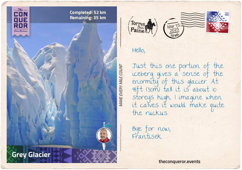
When I reached the top of the pass, the grand Grey Glacier appeared before me in all its expansiveness. The glacier is part of the Southern Patagonian Ice Field, and it flows south into the lake of the same name. It is 17mi (28km) long, 3.7mi (6km) wide and 98ft (30m) high in a stunning shade of cyan-blue colour. I kept an ear out for any thunderous rumbling in case the glacier was calving but without success. Perhaps just as well because in 2019 two large icebergs broke off the glacier. The large one measured 8.8 hectares, that's about the size of 16 football fields or 12 soccer fields, and the second one was about 6 hectares. Fascinating as calving may seem, it is an indicator of rising temperatures that causes glaciers to retreat.
I found myself a place to rest and took in the majesty of the glacier as far as my eyes could see.
km od začátku : 0074
Los Cuernos
The descent from Gardner Pass was quite steep and hard on the knees but I travelled through some more beautiful forest until I emerged adjacent to Grey Glacier with views of the lake in the distance. Southbound, I was now on the western side of the massif. After trekking for 3mi (5km) beside the glacier I crossed the first suspension bridge over a very large ravine. The ever-present wind gave the bridge a nice little wobble.
Barely a mile later I crossed another suspension bridge. By this time the glacier ended, and the lake became my companion until I turned the corner yet again, hitting the southern portion of the massif. Lake Pehoe with its deep turquoise colour was on the downside and on the other was the tallest summit in the park, Cerro Grande Paine, standing at 9,462ft (2,884m). It is a bulky mountain with four peaks and a huge glacier on top that is usually hidden amongst the clouds. This is one of the most challenging mountain climbs in the park because besides the ice, rock and excessive wind there is always the threat of an avalanche.
This next stretch of the hike on a relatively flat trail was a combination of open areas and forest until I reached the third suspension bridge in French Valley with a warning sign saying: "Only one person at a [sic] time on the bridge". The French River was raging in full force beneath the bridge, tumbling over large rocks in an awful hurry to empty into Nordernskjold Lake.
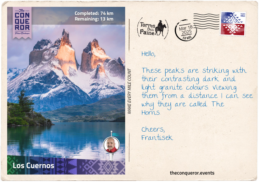
Once on the other side I trekked down to the edge of the milky-blue Nordernskjold Lake which runs pretty much the entire length of the massif's southern part. The trail heads back inland and over a rubble of rock where I was afforded the spectacular views of the Los Cuernos (The Horns) peaks. Besides the incredibly jagged edges of the peaks, what was striking about them were the contrasting colours between the light granite of the central bands and the strong darkness on their tips. Closer to the base, between the two horns, was a narrow waterfall plunging somewhere below that I couldn't see.
Trekking a little further, I stopped at a campsite for a rest before I tackled the remainder of this circuit.
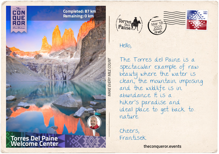
km od začátku : 0087
Torres del Paine Welcome Center
I moved further inland and forged on around the base of the massif with the lake visible down below. On my travels I passed a horseback tour led by Chilean cowboys who are known for their excellent horsemanship. They are highly skilled trackers and guides who develop a very strong bond with their horses. Known for their strong sense of direction and ability to avoid hazards such as bogs and swamps, anyone travelling with them is in good hands. They source water and shelter anywhere and easily move through the night finding their way.
The Chilean horse, aka Criollo, is one of the oldest breeds on the continent. They are typically smaller than the usual North American or European breeds. The Spanish Conquistadors brought the horses in the 15th-16th centuries, and the criollos are their descendants. The breed has had hundreds of years to develop and adapt to the harsh environment of Patagonia.
I reached the entrance of Ascencio Valley, where the famous Los Torres (The Towers) peaks reside. The most magical time to experience the peaks is at sunrise. As the sun rises, the peaks are bathed in a fiery-orange glow. Timing the sunrise is crucial as the glow only lasts a few minutes.
The final section was fording the Ascencio River, heading past Las Torres Hotel and ending my journey back at the Welcome Center where I began. Here, I stopped for refreshments and took the time to look back at the massif with Almirante Nieto being the bulk of the view to the left, Los Torres peeking from behind and Cerro Nido de Condor to the right. It was fascinating to see the green, flat landscape before me but as I scanned upwards the landscape changed to hills, then craggy snow-capped mountains followed by jagged granite peaks.
Contemplating the journey, I was in awe at the varied landscape. There were the wide-open plains and old forests; glacial lakes, rumbling rivers, and the magnificent Grey Glacier; the endless peaks seen from every angle and deep valleys leading into the interior of the massif. The constant throughout the whole trip was the blustering wind. Relentless and intense, it added that extra challenge to my travels.