At the heart of southern Africa, Zambia and Zimbabwe stand as guardians of one of the continent’s most breathtaking spectacles—Victoria Falls—cradling this thundering marvel between them, a UNESCO World Heritage site and celebrated as one of the Seven Natural Wonders of the World.
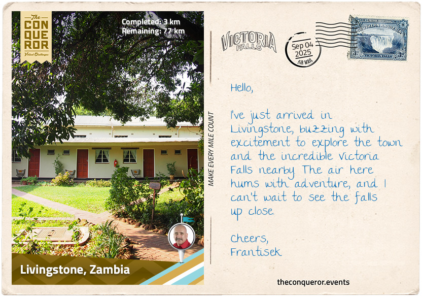
Settled into my accommodation, I set out on a walk to absorb its atmosphere, the warm air carrying the earthy scent of sun-baked soil, mingled with the sweet perfume of frangipani and the faint freshness of the Zambezi River, breathing in the essence of Africa itself. I was eager to immerse myself in its history, to understand how this town, just a short distance from the river, came to be. David Livingstone was a Scottish explorer and missionary who first set eyes on Victoria Falls in 1855. At the time, very few people outside Africa knew about this incredible waterfall, so when Livingstone wrote about it, Victoria Falls burst onto the global stage.
When the Old Drift—a village on the edge of the river that I’ll touch on in the next postcard—was no longer considered a suitable place to settle, it was decided in the early 20th century to move further inland. This gave rise to the town of Livingstone, named in honour of the explorer. It was established as the capital of what was then North-Western Rhodesia, later Northern Rhodesia, until 1935 when the administrative centre moved to Lusaka. Thanks to its proximity to the falls, Livingstone became, and still remains, the main base for visitors. However, it came with growing pains, as Old Drift settlers were reluctant to relocate. The new town was too far inland, 7 mi / 11 km at the time, making it less accessible for tourists eager to see the falls. Despite protests and resistance, the move went ahead, and over time, Livingstone grew into the bustling gateway it is today.
But long before Livingstone’s arrival, the area was home to the Leya people, an ethnic group originally part of the larger Bantu migrations from the Congo Basin. Their culture and traditions are deeply intertwined with the Zambezi River, relying on it for fishing, farming, and daily life. Rich spiritual beliefs hold the river and falls as sacred, honoured through ceremonies and rituals filled with dance, music, and storytelling. These oral traditions have been passed down through generations, keeping their heritage alive and vibrant.
As I wander through Livingstone, I’m drawn to several of the town’s heritage landmarks, starting with the North-Western Hotel. Built in 1907, this once-grand building hosted dances and offered the “finest brands of liquors and cigars” with banquets and private dinners specially catered. Transportation from the train station was a challenge back then. Rickshaws were used at first but proved unpopular until a light rail trolley system was introduced—two benches set back to back, with no motor or handbrake, pushed uphill by four locals. Derailments were fairly common.
Nearby, I spot the Livingstone Museum, housed in a striking Spanish-colonial style building. Opened in 1934, it’s Zambia’s oldest and largest museum, showcasing everything from ancient archaeology and local cultures to colonial history and wildlife. It also holds an extensive collection of memorabilia related to David Livingstone and regularly hosts special exhibits featuring works by Zambian artists.
Lastly, the Railway Museum, set in the old station, tells the story of Livingstone’s rail heritage and the settlers who helped shape this town.
From here, I’ll head to Livingstone Island through Mosi-oa-Tunya National Park.
km od začátku : 0036
Livingstone Island
Leaving the town behind, I set out through Mosi-oa-Tunya National Park, its name meaning “The Smoke That Thunders”, the same name the Leya people gave to the falls themselves. The park was established in 1972 to protect the local wildlife and the falls. It’s essentially split into two—the northwestern side is the wildlife park, while to the south, the Zambezi River pushes through, swelling during the rains before plunging into the Victoria Falls. Though small compared to other reserves in the region, this UNESCO-designated park holds a surprising amount of variety within its borders.
Driving slowly, I spot a pair of giraffes with their necks stretched high into the canopy. Somehow, they manage to stay fresh and rested on hardly any sleep at all, grabbing little naps while standing. Just a few minutes here and there, adding up to maybe an hour or two in a whole day. It’s more like a series of power naps than real sleep. Further along, I pass a few elephants lumbering through the bush, while vervet monkeys chatter from the trees. The highlight, though, is catching sight of the southern white rhinos. There are only a handful here, brought in from South Africa, but they’re still a wonder to see. The endemic black rhino disappeared from this park years ago, though there are efforts to bring them back.
Not far from here once stood the Old Drift, a European settlement established in the 1890s as a river crossing and trading post. Its name came from the point where ox-wagons and travellers drifted across the Zambezi on barges. At first, it seemed like the perfect location: close to the falls, well-positioned for river traffic, and bustling with new arrivals. But this came at a price. The low-lying banks were a haven for mosquitoes, and settlers soon fell ill. They blamed the “fever trees”, which thrived in the same environment, though the real culprit was malaria. Ironically, the fever tree contains compounds that can help treat the disease.
Within a few short years, malaria swept through the community with devastating effect, making it impossible to sustain life there. A decision was made to move inland, giving rise to the town of Livingstone, which I had just been exploring. As expected, some settlers resisted, fearing the loss of profits from the tourist trade, but the relocation went ahead. Only a few graves remain, barely hinting at the Old Drift’s existence.
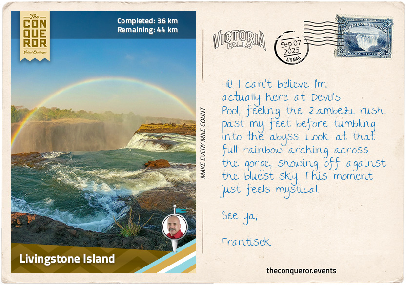
From here, I made my way to Livingstone Island, perched at the very edge of Victoria Falls. Guided by the Leya people, David Livingstone once stood on this same spot, gazing across the mile-wide wall of water. He later wrote that “scenes so lovely must have been gazed upon by angels in their flight.” Standing here now, I can imagine he was just as awed by its thundering power as I am. Livingstone named the falls in honour of Queen Victoria, though its local name, Mosi-oa-Tunya, captures its essence far better.
At the edge of the island lies Devil’s Pool, a natural rock basin where the river briefly pauses before plunging into the abyss. For generations, the Leya people fished these pools. Though safe from hippos and crocodiles, they are always at the mercy of the Zambezi, where one slip could prove fatal. Today, tourists edge into the pool, pushing safety aside for the excitement of inching closer to the roaring drop and capturing the ultimate photograph.
I lingered here for a while, letting the spray from the rising mist settle on my skin, listening to the falls’ rumblings, and understanding why Livingstone was so keen to spread the word through Europe. This is a sight to behold, and while others leaned over the lip for a rush of danger, I felt no need to gamble with the river.
km od začátku : 0040
Victoria Falls Bridge
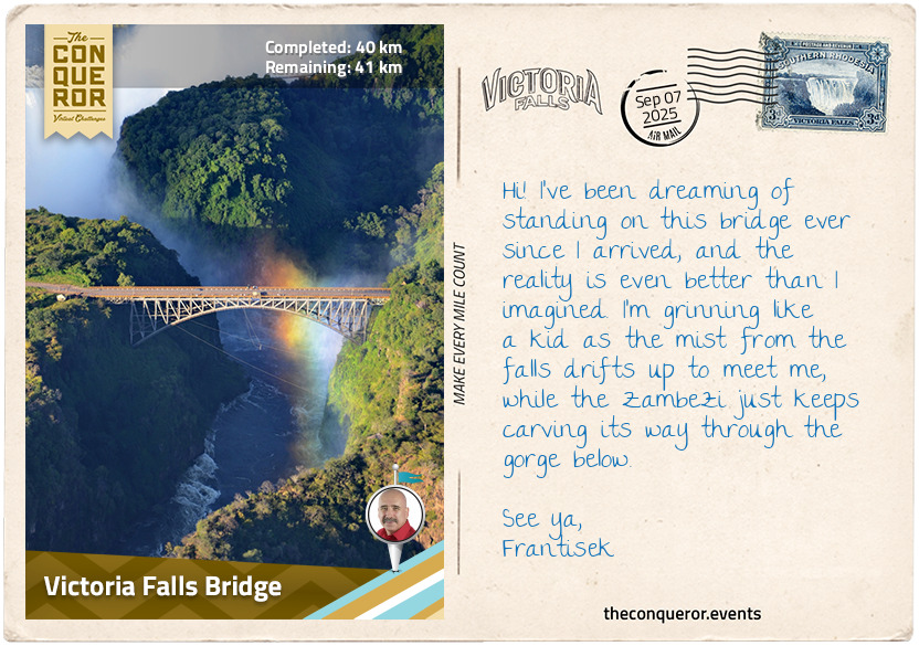
Livingstone may have spread the word through Europe and envisioned a transport route for commerce and missionaries, but it was the ambitions of Cecil Rhodes, a diamond mining magnate and later Prime Minister of the British Cape Colony, who, together with Sir Charles Metcalfe, a friend and associate, made it happen. Rhodes had the grand idea of constructing a railway spanning the length of Africa. The Cape to Cairo Railway, as it became known, was a means to consolidate British interests throughout the continent, including bringing development to the banks of the Zambezi.
Rhodes was lured by the beauty of the falls, romanticising the idea of a railway crossing the Zambezi further south. Despite the river’s deep, steep gorges, it fell to Metcalfe, as Chief Consultant Engineer, to find a practical spot that was easy to reach and didn’t require a wide bridge span. Needing a location with firm rock for bridge foundations, a narrow section was selected about 1,700 ft (520 m) downstream from the main falls. Here, the river could be bridged without extreme engineering challenges, except for a “small” problem that was only discovered when the vegetation and the ground were cleared to excavate the rock: the shelf on the right bank was filled with debris instead of the expected hard rock. With the steelwork preparation already underway, the only way to rectify it was to excavate deeper and lower the bridge by 21 ft (6.4 m).
The bridge was designed and manufactured in England, with the steelwork shipped to Beira, Mozambique, then transported to the site by rail. Construction began in 1904 and was completed by over 400 workers in just 14 months. Assembled from both sides of the gorge, each half of the main arch was held like a cantilever, supported by steel cables anchored into the rock. Without scaffolding and often dangling above the gorge with no modern safety gear, the workers guided the two halves across the central axis perfectly. At first, the sections overlapped by a few inches, but after leaving the steel to cool overnight, they fitted together precisely the next day.
With its gracefully curved arch, the bridge spans 650 ft (198 m) and rises 420 ft (128 m) above the gorge, making it the highest railway bridge in the world at the time. Officially opened in 1905 by Sir George Darwin, son of Charles Darwin, it became a vital link in the Cape to Cairo Railway. However, geopolitics, logistics, economics, and the challenging terrain—rivers like the Zambezi and Congo, the Kalahari Desert, and rugged escarpments—made the full north–south line impossible.
The Victoria Falls Bridge wasn’t immediately embraced by everyone. Some thought it spoiled the view of the falls, including Cecil Rhodes’ brother, Frank, who dryly remarked, “Well, I have done all I could to prevent the bridge being built there; but there it is, and nothing is now left for me to do but pray daily for an earthquake”. Thankfully, no earthquake came, and here I am, standing on the bridge myself, staring across the gorge and marvelling at the sheer courage of the workers who spent long days in the blistering sun, fitting every rivet and steel girder with painstaking care.
Trains no longer carry passengers regularly; the railway is now mostly used for freight, though heritage trains still cross the bridge, pausing midway to offer passengers a view of the falls and the gorge. Even so, the bridge remains an important gateway between Zimbabwe and Zambia, and a lasting reminder of the bold dream of a continent-spanning railway.
km od začátku : 0048
Zambezi River
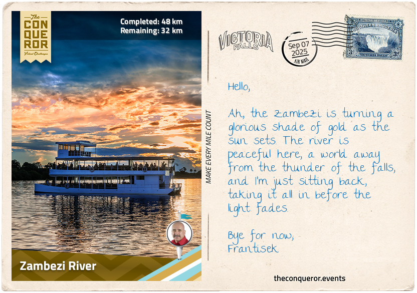
No story about the Zambezi feels complete without tracing its journey from source to sea. It begins as a quiet trickle in the highlands of northwest Zambia, soon widening as it spills into the Barotse Floodplain in the west, one of Africa’s largest wetlands and home to the Lozi people. Life here is tied to the river. When the waters rise, the Lozi move to higher ground in a ceremony known as Kuomboka, where the king leads the way in his royal barge paddled by 100 men. Chanting, dancing, and celebrating are integral to the ritual, as they all pay homage to the river that sustains them. When the floods recede, they return.
The nourishing floodwaters also transform the land. As many as 50,000 wildebeest gather here to calve, the newborns on their feet within minutes and able to sprint and leap within days. But as the rains continue, the river swells, drowning the grassy plains until they resemble an inland sea. As the Zambezi spreads nearly 16 mi (25 km) across, the wildebeest move on to higher ground.
Further downstream, the river meets the Chobe near the Kazungula Bridge, where the borders of Namibia, Botswana, Zambia, and Zimbabwe touch. From here, the Zambezi continues forming the boundary between Zambia and Zimbabwe, passing the Old Drift, and tumbling over Victoria Falls, 350 ft (100 m) into a chasm below—more on that later.
Below the falls, the river squeezes into gorges up to 820 ft (250 m) deep. Here it becomes a boiling torrent, famous for its white-water rapids. Rated as Class V—just one below the maximum grade—they’re fast, violent, and dangerous. Only the most experienced rafters with serious rescue skills attempt them.
As the Zambezi charges on, it eventually collides with an arched wall of concrete: the Kariba Dam. Built in 1960, this 1,900 ft (580 m) long dam holds back a vast 185 cubic kilometres of water—enough to fill around 74 billion Olympic swimming pools—making it the world’s largest reservoir by volume. Behind it lies Lake Kariba, stretching more than 174 mi (280 km) in length and 20 mi (32 km) across at its widest point. Its two power stations supply around 60% of Zambia and Zimbabwe’s electricity.
Local folklore tells of a river spirit called Nyami Nyami, believed to bring fish to eat and water for the crops. So when the dam was under construction and plagued by setbacks—flash floods, hurricane-force winds, and other troubles—the displaced Tonga people thought it was Nyami Nyami taking revenge. In time, though, the benefits of the dam began to show. The thick layers of fertile soil on the lakebed supported an abundance of fish, especially the small, sardine-like kapenta, introduced to the reservoir and now vital to its ecosystem. The Tonga adapted by developing a kapenta fishery, using light at night to draw the shoals into their nets. With their strong smell and salty taste, much like anchovies, kapenta became a local delicacy, heaped high in market stalls across the region.
Downstream of Kariba, the Zambezi gathers more strength from its biggest tributaries: the Kafue and the Luangwa in Zambia, the Shire flowing out of Lake Malawi, and the Luenha in Mozambique. From there, it begins to loosen and braid into channels before finally spilling into the Indian Ocean through the wide, fertile Zambezi Delta. But the delta, as tranquil as it may seem on the surface, has a darker side. Hidden beneath the murky waters, the Zambezi shark patrols, the only marine shark that can thrive in fresh water. You won’t see them coming. They don’t need clear water to hunt as they sense the faintest ripple of movement, the flicker of a pulse, the vibrations of a heartbeat. It’s a reminder that on the Zambezi, there’s just as much happening below as above.
km od začátku : 0060
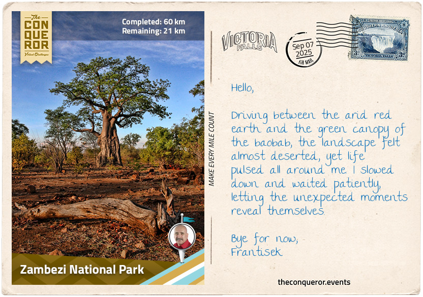
Zambezi National Park
Following the southern banks of the Zambezi, I reached a headland where Rapid 10 was furiously tumbling below. I watched from above for a while, mesmerised by the river’s turbulent flow, before turning away from the water and moving into the lower reaches of Victoria Falls National Park. Dusty tracks led me through thinning mopane, the land opening up under a vast sky. The park was quiet, save for a kudu lifting its spiralling horns above the grass and the distant rustle of a warthog snuffling through the undergrowth.
In the early 1900s, European settlers recognised the uniqueness of this environment and set aside the land for protection. Initially preserved as a forest and then a reserve, it was later officially designated Victoria Falls National Park. Though modest in size compared to its neighbour, Zambezi National Park, it has played a crucial role in protecting the falls and the fragile rainforest.
I jostled along in the car, thankful its suspension was soft enough to absorb the bumps, watching the stirred-up dust swirling and keeping an eye on a nearby waterhole. A herd of Cape buffalo drank at the edge, their massive, muscular bodies and horned bosses radiating raw strength. Every so often, a buffalo lifted its head or flicked an ear, sensing my presence. As I watched from afar, I was aware of how unpredictable these giants could be and kept my distance.
Leaving Victoria Falls National Park behind, I steered seamlessly into Zambezi National Park. Here, open woodlands and hidden waterholes drew wildlife seeking respite from the heat. Sable antelope grazed quietly, their dark coats and sweeping horns contrasting against the golden grass, while an African skimmer with its long orange-yellow beak flitted low across a pool. Nearby, a chestnut goliath heron waited patiently at the water’s edge.
Then movement in the distance caught my eye: an African elephant, seemingly lumbering with deliberate heaviness. But as I watched, its pace revealed a quiet grace, each step measured and focused. The herd followed closely, calves weaving carefully between adults, a living reminder of the park’s history. Once part of Victoria Falls National Park, this area was later designated Zambezi National Park, created to protect the river’s floodplains and woodlands, giving wildlife space to roam away from the crowds of the falls.
Driving past the waterholes and watching elephants guide their young, I felt a keen awareness that these parks have long served as sanctuaries for the diverse wildlife and the broader ecosystem. They have been carefully preserved, allowing the rhythms of the wild to continue, largely undisturbed.
km od začátku : 0071
Victoria Falls, Zimbabwe
Heading north from my safari meanderings, I arrived in the town of Victoria Falls, established in 1901 around the Cape to Cairo railway line. Initially, it supported construction workers with shops, hotels, and transport facilities popping up. As tourism arrived later, the town slowly expanded, becoming a gateway to the falls on the Zimbabwe side, complementing Livingstone in Zambia.
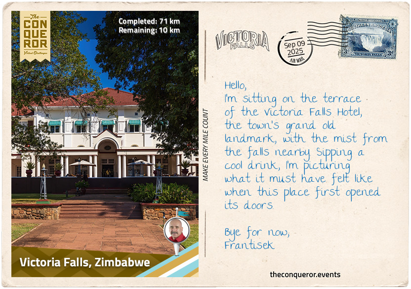
Among the town's early establishments, the Victoria Falls Hotel is definitely its jewel, although it wasn't always perceived that way. Built in 1904, it was originally intended as a temporary structure to house railway workers, engineers, and consultants during the construction of the bridge and railway. It was to be dismantled once the work moved north. With space for only twenty guests, it still offered impressive comforts for the time, including electric lights, ceiling fans, and hot and cold running water.
It wasn't long before tourists began stepping off the train directly in front of the hotel. With demand growing, dismantling was shelved, and instead, railway sheds were converted into dining rooms, and other buildings were repurposed into extra accommodation. As decades passed, the hotel evolved into something much greater, expanding and refining itself into the grand, gracious place it is today.
The hotel's logo—an African lion paired with an Egyptian sphinx—still recalls Cecil Rhodes' ambition of linking Africa by rail from Cape to Cairo. Walking its wide verandas and shaded corridors, I found myself thinking about the many who have stayed here before me. Agnes Bruce, daughter of David Livingstone, visited in 1906, fifty years after her father first set eyes on the falls. Queen Elizabeth II has walked these same corridors, as did Agatha Christie, who drew on her travels here for her third novel.
Stepping out onto the veranda, I chose a chair facing the lawns and ordered a cool refreshment. From where I sat, the view stretched toward the rising plumes of mist from Victoria Falls, drifting above the treeline in the distance. A bubble of excitement stirred in me, anticipation building for when I would stand at the edge of that wonder myself.
km od začátku : 0080
Victoria Falls
I left the cosy comforts of my hotel room, bright and early, the sun barely rising from its slumber. My first stop was the “Big Tree”, a baobab of remarkable girth, measuring an astonishing 73 ft (22 m) around. Before the bridge was built, many travellers congregated here to arrange passage across the Zambezi. From here, the road led me onward to the first of five falls that make up Victoria Falls.
Devil's Cataract sits at the westernmost end of the chasm, separated from the rest of the falls by Cataract Island. The cataract's flow carves many channels and caverns into the bedrock, giving it a rugged and irregular appearance. The force of the Zambezi here speeds up erosion, causing the gorge to reshape and recede faster than the Main Falls. Nearby is a statue of David Livingstone gazing eternally over the falls.
As I pressed on, I entered the fragile, dense rainforest, formed from the constant spray and humidity of the Zambezi. As I wandered through here, I was humbled by the towering mahogany and fig trees while ferns and vines wound through the undergrowth. Amongst the canopies, boldly coloured sunbirds flitted through the branches while finches trilled their sweet song. Occasionally, the unmistakable calls of hornbills and hoopoes echoed above.
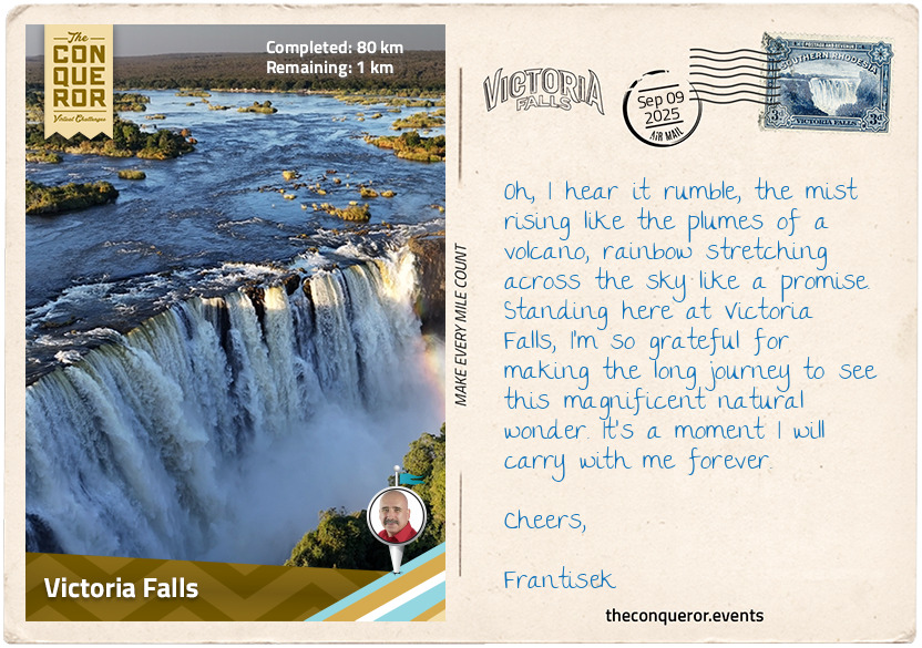
Following the path, I came upon the Main Falls, the largest and most iconic section of Victoria Falls, tucked between Cataract and Livingstone Islands. For a moment, I was awestruck by the sheer power of the water as it plunged relentlessly into the churning gorge below. Mist rose like steam from a boiling cauldron, and as my eyes followed it toward the sky, it slowly dissolved into the sunlight. The roar was deafening, rooting me to the spot as I marvelled at the Zambezi's raw, untamed majesty.
Excited by what I was experiencing, I continued along the winding path, with a spring in my step, eager to see more. Soon, Horseshoe Falls came into view. The name says it all—the water curved in a broad arc, plunging with just as much force as the Main Falls. A little farther on, I reached Rainbow Falls. At 354 ft (108 m), it marks the highest point of Victoria Falls. Here, sunlight pierced the constant mist, breaking into a brilliant rainbow that shifted and shimmered with every gust of wind. But at night, when the moon is full and its light is bright, the same mist transforms into a lunar rainbow, a rare phenomenon known as a “moonbow”. The Eastern Cataract, the fifth fall, is the only one visible from Zambia.
A little further along, I made it to the last viewing spot—Danger Point—an exposed, rocky promontory that was extremely slippery to walk on. I steered clear of the edge and observed the full length of the falls from a safe distance, taking in this incredible mile-wide (1.6 km) torrent of water. Here, the full breadth of the Zambezi plunges into a chasm carved over millennia, like a vast crack torn into the earth. At the height of the rainy season, more than 500 billion litres of water cascade over the edge each minute, sending up a towering cloud of mist visible from as far as 18 mi (30 km) away.
What struck me most was realising that the falls themselves are not fixed in place. The Zambezi is constantly eating away at the basalt, carving the gorge in a jagged zig-zag pattern as it forces the river to retreat upstream. For the last 100,000 years, the water has been dropping over different walls in turn. What we call Victoria Falls today is actually the eighth in this sequence, and it certainly won't be the last. The process has already begun near the Devil's Cataract, where a crevice is slowly being cut into the rock, exploiting its weak points. It won't happen in our lifetime, but in a few thousand years, the falls will abandon their present stage and plunge into a brand-new gorge further upstream.
Standing here, raincoat on and mist clinging to everything around me, I felt small—aware that long after I'm gone, and long after countless others have stood in this same spot, the Zambezi will still thunder on, carving through the earth, one relentless drop at a time.