Vietnam is a long, narrow country in Southeast Asia bordered by Cambodia and Laos to the west, the South China Sea to the east, and China to the north. It is known for its beaches, bustling cities, ancient towns, scrumptious cuisine, and, wouldn’t you know it, for its coffee culture? It has 8 UNESCO Heritage Sites, glistening skyscrapers, French Colonial architecture, citadels and, as expected, many pagodas and temples.
Vietnam is often referred to as the ‘Land of the Ascending Dragon’, and while there are different reasons for the nickname, my favourite explanation is its geographical shape. I took one look at it and could see the top of the country shaped like a dragon head with a slithering body following, almost as if ascending. An alternative meaning is based on a legend and Vietnam’s long-standing association with the dragon. In this mythological story, Vietnamese people were descended from a dragon and a fairy. The dragon brought the fairy to earth to teach the people to cultivate rice and create a civilisation. The dragon is a symbol of power, strength and good fortune, and it is believed to bring prosperity and protection to the people. Given their significance, dragon motifs are often incorporated into art, architecture, folklore, festivals and celebrations.
Travelling the entire length of Vietnam by motorbike is a popular adventure for many tourists. Motorbikes are a common mode of transportation, allowing tourists to experience and blend in with the local culture. It also opens up the opportunity to explore the whole coastline of Vietnam, tackling it from Hanoi in the north to Ho Chi Minh City in the south with side trips to Ha Long Bay or the Mekong Delta.
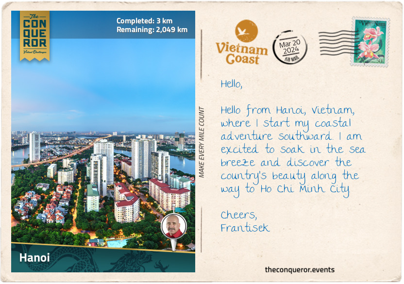
Hanoi is the oldest capital in Southeast Asia, founded in 1010. Then known as Thang Long, the city was built around the Imperial Citadel, serving as the political and cultural centre of the country. In 2010, it celebrated 1000 years, and to mark the occasion, the Hanoi Ceramic Mosaic Mural was created along the Red River dike system. This incredible 2.5mi (4km) long mosaic was the brainchild of a local journalist who loved the city so much she wanted to commemorate it. Crafted from ceramic tesserae, the mural tells the story of Vietnam’s history by merging modern art with children’s paintings. The collaboration to create this wall brought together over 600 local and international artisans and children. The artwork is colourful and striking, culminating with a stunning ceramic panel of two dragons at Chuong Duong Bridge near the Old Quarter.
Hanoi is the birthplace of water puppetry, a traditional Vietnamese art form that originated in the Red River Delta, with performances held in flooded rice paddies. It has now evolved into a professional stage performance. The brightly coloured puppets are made of lightweight, water-resistant wood like that of a fig tree. They are manipulated by puppeteers who stand in a waist-deep water stage. Using dramatic music from live orchestras and special effects such as fire-breathing dragons, the puppeteers tell stories from a villager's perspective about daily life and Vietnamese folklore.
One of the most revered cultural sites is the Temple of Literature. Dating back to 1070, it was originally built to honour Confucius. It later transformed into Vietnam’s first national university. The Imperial Academy functioned as an educational institution for royals and aristocrats for 700 years until it was relocated to Hue. Throughout its manicured gardens and traditional architecture is a series of stone stelae on the backs of turtles showing the names of candidates who succeeded in their royal exams. The Temple of Literature is a symbol of Vietnam's commitment to education and the pursuit of knowledge.
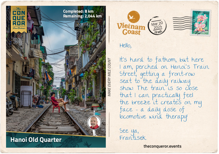
As I meander through Hanoi’s streets, I head toward the Old Quarter and the fascinating Train Street.
km od začátku : 0008
Hanoi Old Quarter
The Old Quarter is an elaborate web of narrow streets and traditional architecture. It developed during the imperial period of Thang Long (Hanoi’s former name) when the king moved the capital to the area in the 11th century. Artisans and craftsmen began setting up shops to cater to the needs of the palace. As time passed, the Old Quarter developed a guild system, with each street dedicated to a particular trade or craft. It originally consisted of 36 streets, but it expanded over the centuries, and today, it encompasses more than 70 streets.
As I stroll through the cozy alleys, I am in awe of the hundreds of little shops and cafes, bustling with activity, offering specialties such as silk, jewellery, bamboo and traditional medicine. Here, artisans share their skills and craftsmanship in family-run workshops while all around me, I could smell wonderful dishes of steaming noodle soup, grilled meats, and spring rolls.
But the most unique experience is west of the Old Quarter on Train Street, where trains run through three narrow residential streets, just inches away from the buildings on either side. The railway tracks were built during the French colonial period (1887-1954). Over time, houses and shops were constructed beside the tracks. The space between the tracks and the buildings is so narrow that when the train passes, it looks like it's threading its way through the eye of a needle.
Locals living here are used to the situation. Each time a train passes, they move their belongings, sometimes even furniture, indoors. You can imagine what a spectacle this would be to tourists and foreigners. It looks like organised chaos, and as soon as the train passes, everything comes back out. A fun and safe way to experience this is to pull up a seat at one of the cafes, located pretty much on the edge of the tracks and be prepared to be wowed. Word of advice: stay off the tracks and keep your hands to yourself.
km od začátku : 0103
Nam Dinh
I left Hanoi, heading south alongside the Red River. Known as Song Hong in Vietnamese, it is one of the most significant rivers in Vietnam. Flowing for 714mi (1149km) from the Yunnan Province in China through northern Vietnam, it forms the Red River Delta before emptying into the Gulf of Tonkin. Its English name is derived from the reddish-brown sediment it carries.
Annual flooding and sediment deposits make the Red River Delta one of the most fertile regions in Vietnam and a haven for rice cultivation. It is often nicknamed the “Rice Bowl”, and rightly so, because aside from being a staple food in the Vietnamese diet, Vietnam is one of the world’s largest producers and exporters of rice.
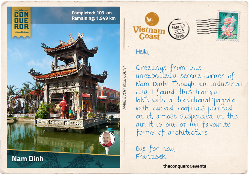
Continuing, I reached Nam Dinh City, the capital of Nam Dinh province, and a textile sector leader. In 1898, French colonists established the Nam Dinh Textile Factory, employing over 18,000 people. It was the largest factory in Indochina. When the textile factory relocated in the 2010s, the site was repurposed into a textile museum displaying large looms, textiles, personal effects of President Ho Chi Minh from his visits and military memorabilia related to the area.
Nam Dinh may have suffered a slump in the industry in the 1990s, partly due to a shortage of workers. However, since the 2000s, the sector has been rising, housing nearly 480 textile companies with over 70,000 workers.
Each August, Nam Dinh holds the Co Trach Festival, honouring the 13th century General Tran Hung Dao, a military strategist who defeated the invading Mongols led by Kublai Khan, the grandson of Genghis Khan. His most famous victory was the Battle of Bach Dang River in 1288, when iron-tipped wooden stakes were planted in the river, immobilising the Mongol fleet as the tide changed. His victories solidified him as a national hero, and he is regarded as one of Vietnam’s greatest military tacticians. Statues commemorating him have been installed in several cities, along with many streets, schools and wards named after him.
The city may not be as well-known internationally, but it can definitely boast as being the birthplace of the iconic Vietnamese dish, pho, a flavourful noodle soup that originated in Nam Dinh. I’ll tell you more about this later. In the meantime, see you in Ninh Binh.
km od začátku : 0134
Ninh Binh
I have arrived in Ninh Binh City, the gateway to and capital of Ninh Binh Province. While the city is not known for historical attractions, it is a terrific base for me to explore the nearby sites. Ninh Binh is often referred to as "Halong Bay on Land" because of the gorgeous karst formations that rise dramatically from the vibrant emerald rice paddies and meandering rivers.
There are some stunning historical locations, such as Hoa Lu, the ancient capital of the 10th-century Dinh Dynasty. Dinh Bo Linh was a military leader who secured Vietnam’s independence from Chinese rule. Declaring himself emperor and founding the Dinh Dynasty, he unified Vietnam and brought stability and prosperity to his people. Although his reign was short-lived, his legacy is commemorated with his tomb on the grounds of Hoa Lu.
The grounds of Hoa Lu are extensive, and although many of the ancient buildings lie in ruins, the serenity of the location, surrounded by karst formations and the meandering Sao Khe River, makes it a worthwhile visit. The Dinh Dynasty was succeeded by the Early Le Dynasty, which was credited for introducing Vietnamese currency. After serving as the capital for 46 years, Hoa Lu was replaced, and the king of the Ly Dynasty relocated the capital to Hanoi.
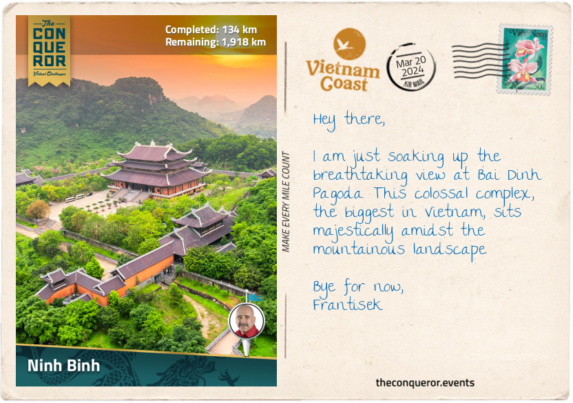
A few miles northwest of Hoa Lu is Bai Dinh Pagoda, the biggest temple complex in Vietnam and one of the largest in Southeast Asia. Although its history dates back to the 11th century, significant expansion and reconstruction took place in the 21st century, turning it into a Buddhist complex with a mix of traditional and modern architectural features. Containing 500 arhats (enlightened Buddha) statues, the highlights are the 100-ton gold-plated bronze Buddha, the 13-storey stupa (at 328ft/100m, it is the tallest in Asia) and the 1000-year old, moon-shaped Jade Well, which at 98ft (30m) in diameter and 20ft (6m) deep, never dries.
Further afield is Cuc Phuong National Park, the first and one of the largest national parks in Vietnam. Established in 1962, the park is primarily a tropical forest and home to more than 100 species of wildlife and over 300 species of birds. The Endangered Primate Rescue Centre is within the park, focusing on the rescue, rehabilitation, breeding, research, and conservation of endangered primates such as langurs and gibbons.
Since the park is not on my route, I will head south toward Trang An.
km od začátku : 0148
Trang An
If you’re a fan of the modern version of King Kong and have seen Kong: Skull Island (2017), rewatch it, and if you can identify the limestone peaks and river systems, you’ll notice that some of the stunning filming locations are in Ninh Binh at the Trang An Landscape Complex, a UNESCO World Heritage Site. Trang An is known for its diverse ecosystem, karst peaks, caves, and grottos.
The best way to explore this area is by boat. Sitting in a sampan, a flat-bottomed wooden boat with a wide hull, I am peacefully gliding through the waterways. The river is framed by vibrant green rice fields and forest-green karst peaks jutting from the valley. As I navigate, I can see locals paddling their boats, each wearing the iconic conical hats, providing them shelter from the sun and adding a touch of tradition to the serene scene.
As a side note, when traveling through Asia, particularly in rural areas, one will notice that many villagers, farmers, or fishermen use conical hats as protection from the elements. However, the conical shape and design vary depending on the country. For example, in Vietnam, the hat is known as ‘Non La’, and features a wide, flat brim and a pointed cone shape at the top. It is typically crafted from woven palm leaves or bamboo and secured with a cloth chin strap.
In the highlands of Bhutan, small ornamental conical hats are woven from bamboo strips, resembling basket weaving. They are topped with a pointed spike and adorned with strands of colorful beadwork. The Japanese conical hat, called tokin, has a pointed top and a wide brim, often made from rice straw, with occasional lacquer application for waterproofing.
On the other hand, in Thailand, particularly in Bangkok's Floating Markets, locals wear the Ngob hat, which, while conical in structure, is flat-topped, giving it a unique appearance compared to the typical conical hats.
Continuing my journey, I let the gentle current carry me onward, past a pagoda built in the river, standing like a sentinel. But the most exciting part of this gentle meandering is the cave systems hidden beneath the towering peaks. Son Duong Cave, for instance, is known for its exquisite stalactites shimmering in pure white and emerald green, while Toi Cave is best seen with a torchlight since its interior is dimly lit. Nau Ruou Cave, translated as Cooking Wine Cave, is aptly named since people who lived there used the well found inside to make wine. Because the caves in Trang An are closely located, it’s easy to go cave hopping. Still, the best cave of them all is Dia Linh Cave, as it’s nearly a mile (1500m) long with many twists and turns.
This is a truly beautiful location dressed in a wonderfully diverse palette of green shades, from the lush, emerald-green rice paddies and deep green foliage blanketing the karst formations to the serene waterways with its blend of turquoise and jade. It is just splendid.
km od začátku : 0222
Thanh Hoa
Thanh Hoa is a large, developing city and the capital of the Thanh Hoa Province. Located on the Ma River, the city is surrounded by mountains and rural countryside.
My first stop was the historic landmark Dragon Eye Cave (Long Quang Cave). More than a natural landscape, the cave is deeply intertwined with the city’s history and the 15th-century reign of Emperor Le Thanh Tong of the Le Dynasty. According to legend, the Ham Rong mountain range, where Dragon Eye Cave is located, symbolises a nine-piece dragon. Lying beside the Ma River, the dragon’s head is identified as the Dragon's Eye, the mountain range is its body, and the tail is at the other end in Dong Son village. The cave, about 328ft (100m) deep, was a place of respite for Emperor Le, where he would inscribe poems into the cave’s ceiling.
During the Chinese Ming Dynasty's occupation of Vietnam in the early 15th century, Le Loi, as he was known, led military campaigns against the invaders with the help of a magical sword. According to folklore, when Le Loi cast a net while fishing on a lake, he suddenly felt a powerful force pulling on his net. When he reeled in his catch, he found a sword entangled in the net. The sword, Heaven's Will, was considered sacred and seen as a sign from the heavens. It was said to have magical properties, emitting a radiant light and bestowing strength and courage to lead a successful resistance upon Le Loi. In 1426, he achieved a victory at the Battle of Dong Quan. After the battle, a golden turtle came to collect the sword and returned it to the dragon master in the lake, never to be seen again.
Carrying on with my exploration, I visited Truc Lam Ham Rong Zen Monastery at the top of the hill near the cave. It is beautifully nestled in a vast pine forest, comprising 12 intricately designed buildings, including the Ancestral Church, bell tower, and drum floor. Surrounded by a peaceful ambiance and views over Ma River, I found the monastery a lovely place to rest and relax.
km od začátku : 0306
Red Lacewing Butterfly
Thanks to its rich biodiversity and varied ecosystem, Vietnam is home to more than 400 butterfly species. Although according to a scientific paper by an entomologist, there are more than 1100 species in Vietnam. Regardless of which is true, there is a great number of these sweet and delicate creatures flittering through the air in a myriad of colours.
The scientific term for butterflies is “Rhopalocera”, derived from the Greek words "rhópalon", meaning club, and "kéras", meaning horn, which refers to the club-like antennae that butterflies possess. What distinguishes butterflies from moths (Heterocera suborder) is their daytime behaviour and being relatively colourful, unlike moths' muted and nocturnal habits. Butterflies have beautiful intricate patterns and soar gracefully in flight like pirouetting ballerinas.
Butterflies play many important roles in the ecosystem, most importantly as pollinators of flowering plants, contributing to the production of fruits and seeds. They are also a biodiversity indicator. Changes in butterfly populations can signal shifts in environmental conditions, such as habitat loss, pollution, or climate change. Monitoring butterflies can help scientists assess the well-being of ecosystems. Butterflies are crucial in the food chain as they are both prey for various animals and contributors to the life cycle of their species, as caterpillars - the larval stage of butterflies - use specific host plants for feeding and development. And finally, they are just a sight to behold, adding beauty to our world.
This biodiversity can be experienced in Vietnam at any of its major national parks (N.P.). For instance, with its karst formations and dense forests, Cuc Phuong N.P. provides an ideal habitat, while Bidoup Nui Ba N.P. in the Central Highlands, with its montane forests and grasslands, is home to rare species like Teinopalpus aureus (swallowtail family) or common ones like Troides helena (birdwing family).
Out of the hundreds of species, I wanted to focus on at least one of them. The lacy wing pattern of the Red Lacewing Butterfly (Cethosia biblis) was difficult to pass up. It is known for its striking and vibrant colours, with a layered mix of red, orange and white and delicate black patterns on its wings that give the butterfly its name.
These butterflies are found in different parts of Southeast Asia, including Vietnam, where they like to live in tropical areas with lots of plants. They prefer forests and gardens with their favourite plants, such as passion vines, where their caterpillars can munch on the leaves. The red lacewing uses its bright colours to warn other animals that it might not taste good or be harmful—a trick known as mimicry. Like all butterflies, they go through different stages in their life, starting as eggs, turning into caterpillars, then into pupae (chrysalis), and finally becoming adults.
While Red Lacewings are not in danger of disappearing, unlike the Teinopalpus aureus mentioned above, many other species face problems like losing their homes and environmental damage. Conserving their habitat is important.
Besides being important for nature, butterflies, including the red lacewing, have special meanings in different cultures. They often symbolise transformation, hope and life.
So the next time you see a caterpillar munching away at your plants, think of the butterfly this wiggly, hungry creature is preparing to transform into and the rainbow-like colours it will add to the world around us.
km od začátku : 0377
Vinh
Vinh is a vibrant city in North-Central Vietnam, an important east-west economic corridor connecting Vietnam with Myanmar, Thailand and Laos, and a north-south transportation route connecting Hanoi with Ho Chi Minh City.
Delving into Vinh’s history, the city played a major role in Vietnam’s past. It was originally known as Ke Van but underwent various name changes before settling on Vinh in 1789. During the Tay Son Dynasty (18th-19th century), the city was considered a possible capital of Vietnam and, for a time, as the gateway to the south when Vietnam only occupied the north. When the French colonised Vietnam, the city was developed into an industrial centre with many factories popping up.
Several notable figures were born in Vinh, including Ho Chi Minh, the founding father of modern Vietnam. He served as President for 24 years in the mid-20th century until his death. His childhood home is in a small village in Kim Lien Commune, a short distance from the city. The villagers constructed a 5-room wooden house with a thatched roof to recognise President Ho’s father, the first villager accredited by the Hue royal court for passing his Confucius examinations. Today, the house contains the family's preserved artifacts, including the car used during Ho Chi Minh’s visits, personal items, and a memorial portrait.
The city’s main square is home to the tallest statue of Ho Chi Minh in all of Vietnam. The statue stands at 50ft (18m) and is made of 200 tonnes of copper-coloured granite. It is surrounded by 1600 species of trees from different Vietnamese regions and large planter boxes with bonsai-like trees.
Cua Lo Beach is a short distance northeast of the city and boasts a 6mi (10km) stretch of pristine white sandy beach, turquoise waters, and a backdrop of coconut trees. Nestled not far from the shore are three islands that serve as both quiet getaways and protective barriers against storms and strong ocean winds. The local fishermen deliver their daily catch, making the area a fantastic spot to indulge in fresh seafood, such as shrimps, crabs, and cuttlefish. It is a great way to savour the flavours of the sea right here on the beach.
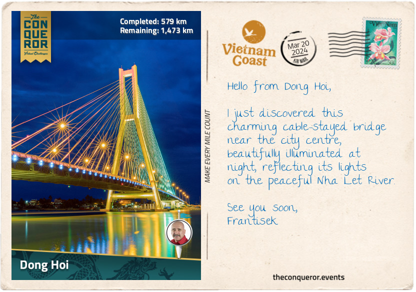
km od začátku : 0579
Dong Hoi
Dong Hoi is a lovely coastal city in the narrowest part of Vietnam, stretching a mere 25mi (40km) from east to west. It is often overlooked as a tourist destination. However, this quiet location offers gorgeous beaches, like the soft white sand of Nhat Le Beach, and crystal-clear waters that are perfect for swimming.
Situated on the west side of the Nhat Le River, Dong Hoi Citadel is a star-shaped fortress constructed in the 19th century by the Nguyen Dynasty. Built with bricks and stone, it served as a defense against foreign invaders and was a military stronghold during colonisation. Like many fortresses around the world, it was surrounded by a moat—a defensive barrier of water to make attacks difficult for invaders. As I walked around the remnants of the citadel, I envisioned the strategic moves that once took place within these weathered walls.
Behind Nhat Le Beach was Bau Tro Lake. This large, oblong-shaped freshwater lake is also an archeological site where Neolithic-era artifacts have been found. Dong Hoi itself can trace its human settlement history back 5,000 years. The lake is surrounded by lush greenery, offering a serene retreat from the city’s hustle and bustle.
Venturing north from the beach and lake, I stumbled upon the Quang Phu Sand Dunes. I couldn't resist grabbing a sandboard and whooshing down the dunes, feeling the wind rush through my hair as I squealed with joy. And when that wasn't thrilling enough, I rented an ATV as the next best thing and had an exhilarating ride through the sandy landscape.
I finished my exploration of Dong Hoi at the night market near Nhat Le River, where the sun was casting a fiery hue of orange, pink and purple as it was dipping over the horizon. The market was bustling with fresh produce for sale, the chatter of people, and local entertainers. I was curious about local food and tried their special snack, Khoai deo. Made from dried sweet potato, it was sweet and chewy. I also tried Banh Beo, a small steamed rice cake topped with minced shrimp, scallions and crispy fried shallots.
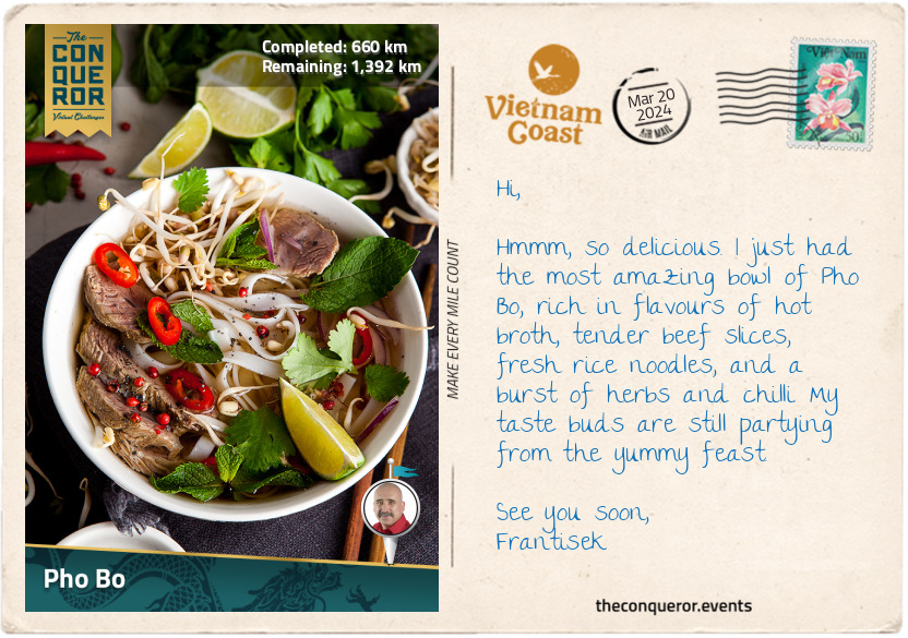
km od začátku : 0660
Pho Bo
Oh, the delight of Vietnamese cuisine with signature dishes particular to each region. There’s the:
1. Bun Cha, grilled pork served with vermicelli noodles and dipping sauce in North Vietnam,
2. Ban Khoai, rice flour and turmeric pancake filled with pork, shrimp, bean sprouts and onion in Central Vietnam, or,
3. Can Chua Ca, a sweet and sour catfish soup with veggies and herbs in the Mekong Delta, Southern Vietnam.
Vietnamese dishes burst with savoury, sweet, sour, and rich flavours, often enhanced by aromatic herbs and spices like basil, mint, cilantro (coriander), ginger, garlic, shallots and fennel seeds.
The most iconic Vietnamese dish is Pho Bo, a rice noodle soup featuring beef, herbs, and chili. Its vegetarian counterpart is known as Pho Chay. What makes Pho Bo so special, you might ask? The key lies in its broth, cooked for a long time by simmering beef bones, charred onions, ginger, and spices like star anise and cinnamon. The slow-cooking process results in a broth with a rich and deep flavour. Pho Bo maintains a light and delicate quality, unlike heartier Vietnamese beef recipes. Once the broth is ready, toppings are added. Rice noodles soak up the flavourful broth, providing a satisfying chewiness. Thin cuts of sirloin, brisket, meatballs, and tendons offer complexity and variety. The dish is completed with bean sprouts, basil, spring onion, cilantro, a squeeze of lemon or lime, and chopped chili for added zing.
Just as with any culinary creation, the preparation of Pho Bo varies across different regions and is served any time of the day, particularly for breakfast. The long preparation to achieve the most exquisite flavours is truly a labour of love.
Are you game to try and make it at home? Here’s a recipe that’s kinder on time, has easily accessible ingredients and has plenty of tips and tricks to help you with your cooking journey.
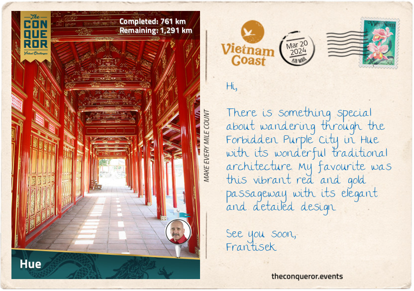
km od začátku : 0761
Hue
I have arrived in Hue, and one of the best ways to explore this ancient city is on a boat ride along the beautiful wide Song Huong (Perfume River). The boat I boarded was decorated with dragon heads, once favoured by the emperors. I gently meandered on the river and enjoyed seeing several of Hue’s landmarks.
The first was the Hue Imperial City and Citadel, a UNESCO World Heritage Site. This complex of palaces, temples, and fortifications was Vietnam's imperial capital from 1802 to 1945 and the seat of the Nguyen Dynasty. The huge fortress with three concentric enclosures and surrounded by a 6mi (10km) moat uniquely blended Chinese and Vietnamese architectural styles. The impressive Ngo Mon Gate is a grand entrance to the citadel made of massive stone slabs upon which the Five Phoenix Watchtower rests. It is so called because when seen from above, it resembles five phoenixes. As a side note, the phoenix, dragon, unicorn and tortoise are the four sacred animals in Vietnamese culture, each representing one of these traits: power, intellect, longevity and nobility. Can you guess which animal is associated with which trait?
Gorgeous red and gold-like colours adorn the watchtower with a green and yellow glazed roof. It is decorated with dragon reliefs, bats and banyan leaves and further embellished with ceramic mosaics of orchids, chrysanthemums and bamboo. The emperor used the pavilion for state occasions.
Within the citadel is the Forbidden Purple City, the emperor’s home where no other man was permitted to enter. Access was given only to the queen, concubines, female servants and eunuchs. In the northeastern Quarter was the emperor’s Royal Library, where he would retreat to read quietly and enjoy the garden and pond.
Heading southwest on the river, I passed by the Thien Mu Pagoda, an iconic symbol of and the oldest temple in Hue. It is a Buddhist temple built on a hill dominated by a seven-storey octagonal tower called Source of Happiness. It offers a great view of the river. Nearby in a pavilion is a huge bronze bell weighing over 4,400lb (2,000kg), which apparently can be heard at least 6mi (10km) away.
You may recall at the beginning, I mentioned the Temple of Literature in Hanoi, which was relocated to Hue when it became the capital city. The emperor built the academy in 1808. Sadly, it was heavily damaged through various wars. However, 32 stone stelae atop turtles' backs are placed inside the central courtyard. The stelae carry the names and towns of individuals who passed the rigorous Imperial Examination.
Rounding a horseshoe bend, I head for the Royal Tombs of the Nguyen emperors.
The Four Sacred Animals and their Symbolism
1. Dragon –power, strength, and good fortune. Represented the emperor and his authority.
2. Phoenix – nobility, rebirth, and regeneration, hence the phrase “like a phoenix rising from the ashes”. Triumphantly coming back from a period of difficulty.
3. Unicorn – harmony, mercy and intelligence. It’s a hybrid creature that is half dragon, half mammal.
4. Turtle – longevity, protection and wisdom. Remember the legend of the golden turtle and the magic sword (see Postcard 6).
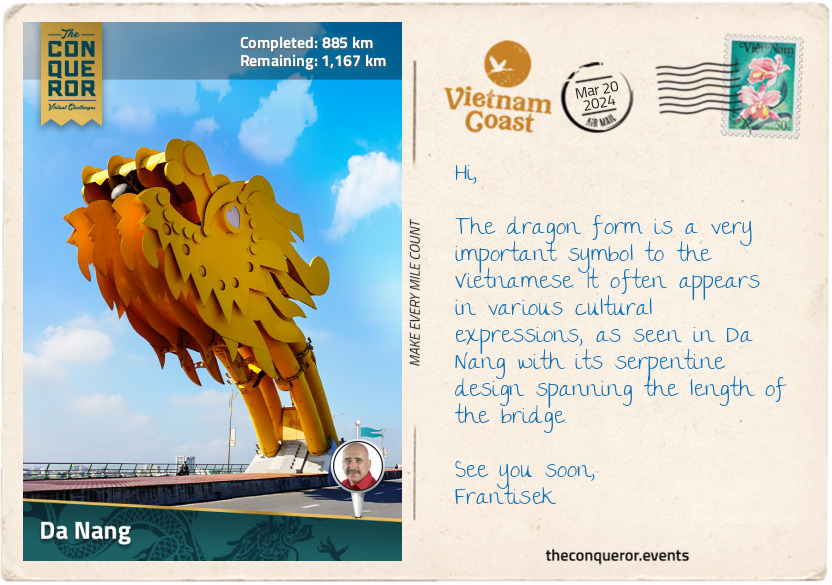
km od začátku : 0885
Da Nang
Da Nang is nearly halfway along Vietnam’s coastline and is the third most important city after Hanoi and Ho Chi Minh City. It is famous for its beautiful beaches and two fascinating bridges admired for their architectural features. Dragon Bridge, aptly named for its dragon shape, spans the Han River for 2,185ft (666m). Illuminated with colourful LED lights at night, the dragon breathes fire and spouts water on weekends and special occasions. The Golden Bridge, west of the city in the Ba Na Hills, is fabulously held aloft by a pair of giant hands emerging from the hillside, giving the illusion that the bridge is being lifted by these colossal hands.
Northeast of the city, on a peninsula, is Son Tra Mountain, also known as Monkey Mountain, named after the red-faced monkeys that used to frequent the area. Accessed via a winding road, a visit to the summit is absolutely worthwhile for the spectacular views of the sea, the city and the surrounding verdant landscape. On the way up, I stopped at the Ling Ung Pagoda to visit the tallest Buddha statue in Vietnam, Lady Buddha Da Nang. She’s a beautiful 220ft (67m) tall, pure white statue with a serene face, holding holy water and wearing a Buddha on her hat. She stands tall on a lotus-shaped platform. Inside the lotus are 17 floors, each with 21 Buddha statues in different shapes, expressions and postures. The statue is so tall and striking that it can be seen from anywhere in the city.
From the base of the Son Tra peninsula begins the 6mi (10km) long My Khe Beach. White sandy beaches, turquoise waters, and palm trees create a peaceful, relaxing atmosphere to soak up the sun and frolic in the gentle waves.
As inviting as it was to stop here, I chose to continue toward Marble Mountains, a cluster of five marble hills riddled with caves and dotted with Buddhist shrines and Hindu grottoes. Each hill is named after one of the five elements – Kim (metal), Thuy (water), Moc (wood), Hoa (fire), and Tho (earth). Only Thuy was open to visitors. It was accessed via steep steps, through dense foliage, dark cave passages and past several cave temples. Once I reached the summit, I had the pleasure of another panoramic view of the city, the beaches and the peninsula.
The next destination is the ancient town of Hoi An.
km od začátku : 0950
Hoi An
The ancient town of Hoi An dates back to the 15th century when it was an important trading port later superseded by Da Nang. The Old Quarter, as it’s commonly referred to, has been designated a UNESCO site and is known for its colourful architecture, narrow streets and historic temples. The town may be small in size, but it is big in terms of foot traffic. To alleviate traffic pressure, the local government has blocked vehicles from entering the town.
A pleasant way to experience the town was on a boat, cruising along the Thu Bon River, revealing a series of dark-yellow houses on its northern bank. These well-preserved buildings showcased a wonderful mix of Chinese, Japanese, French, and Vietnamese influences. Delicate wooden carvings and shutters complemented the yellow façade, decked with colourful lanterns.
One block behind the riverbank stands the House of Tan Ky, one of Hoi An's most cherished preserved properties. This architectural gem, blending Vietnamese, Japanese, and Chinese styles, has been in the same family for over 200 years, passing through seven generations. Meticulously preserved, the house is 2-storeys with a traditional yin-yang tile roof (a roofing pattern consisting of square-shaped tiles that are slightly curved and placed in repeated rows of upside down and right side up) and finely carved trusses and columns joined together like a puzzle without the use of nails. The living room was built according to Feng Shui principles, and the five elements (metal, wood, water, fire and earth) around a central courtyard with a skylight for natural light and to regulate the airflow inside. Filled with antiques on the lower floor and open to visitors, the house continues to be occupied by the family residing on the upper floor.
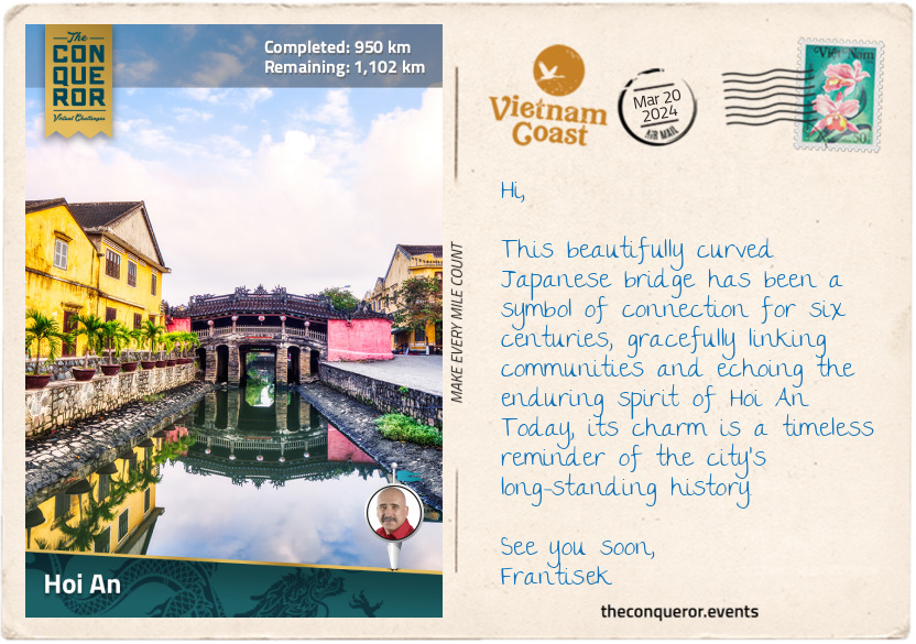
At the west end of the Old Quarter, a tiny river tributary leads to Chua Cau, meaning Pagoda Bridge. It is more commonly referred to as the Japanese Covered Bridge. But to add to the confusion, the bridge’s official name is Lai Vien Kieu. The bridge was constructed in 1593 by the Japanese to connect its community with the Chinese Quarter further east. Trade between the two communities flourished until the mid-17th century when the Tokugawa Shogunate (Japanese military government) closed its borders to international trading, and all its citizens abroad had to return home. A small pagoda was later built in the centre of the bridge with a shrine to Bac De, the God of Weather. During the French occupation (1887-1945), the bridge was flattened to allow motorbikes to cross it. Recognising the bridge's historical value, in the late 1980s, it was restored to its original arched design and made accessible to pedestrians only.
Having worked up an appetite, I aimed for one of the street food vendors for a serving of Hoi An Chicken Rice (Com Ga Hoi An). The dish appeared in Hoi An around the 1950s but is widely known throughout Southeast Asia. It is made of shredded chicken and yellow rice, served with a bowl of hot chicken broth and sweet and sour salad. Sounds delicious and filling.
km od začátku : 1014
Tam Ky
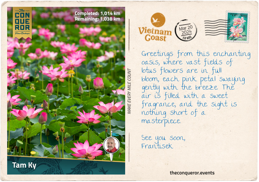
I arrived in Tam Ky with a single purpose: to see lotus flowers in full bloom. Every summer, these delicate blossoms transform the rivers and lagoons into a mesmerising sea of pink hues. Thriving in muddy waters, the lotus emerges clean and pristine each morning. It sinks below water each night, only to re-emerge the next day. This daily spectacle may last several weeks before going dormant until the next season.
The Vietnamese hold the lotus in high regard, viewing it as a symbol of purity, strength, and optimism. The flower is deeply embedded in their culture, serving as the national flower and is spiritually valued. It is depicted in Buddhist art with Buddha seated on a lotus, representing the connection between enlightenment, purity and the flower.
The lotus is not just a symbol of beauty. It is also a practical and edible ingredient in Vietnamese cuisine. For instance, the young lotus stems, crisp and tender, are added to salads, stir-fries, and traditional hotpots. The flower is usually dried, and the petals are used to infuse fragrance with a subtle floral aroma into tea. The leaves are also used in tea and are believed to help digestion. The seeds, prized for their nutritional value, are often found in sweet soups and desserts or toasted as a tasty snack.
The lotus is so significant that even modern buildings, such as the Bitexco Financial Tower in Ho Chi Minh City, reflect its influence. Inspired by the national flower, the architect designed the building to resemble a lotus bud, adding a touch of culture to the city's modern skyline.
The best time to see the lotus is early morning, just as they rise from the water. I took advantage of that by hopping into a sampan with a guide to glide between the lotus plants and admire the perfect blossoms while sipping a robust local coffee.
km od začátku : 1088
Quang Ngai
I arrived in Quang Ngai City, the capital of Quang Ngai province. I used the city as my base to explore the region, beginning with a nearby hike up to Thien An Pagoda atop Thien An Mountain.
The pagoda is nestled in Tinh An Dong Commune and stands at 328ft (100m) above sea level amid a dense forest. Constructed in the late 17th century, the pagoda is among the town's oldest sacred sites. Legend tells the story of a time when locals wanting to avoid wild animals only gathered firewood at the base of the mountain until one day, they found a winding path that led to the mountaintop and encountered a Buddhist practitioner who imparted wisdom and compassion to those who crossed his path.
The pagoda’s main gate, adorned with intricate dragon motifs, serves as a guardian entrance. The tombs inside, shaped like lotuses, hold the resting places of monks and abbots. A sacred well, still in its original state, was built on the east side to provide water to worshippers who visited to learn about Buddhism.
The pagoda's iron bell bears a mystical tale. When first cast in a nearby village, the bell was silent. However, one day, while in deep meditation, an abbott was instructed by a spirit to move the bell from the village to the pagoda, when it magically began ringing nice and loud through the region.
A meander around the grounds affords panoramic views across the city and the rest of the region. Near the pagoda is the tomb of Huynh Thuc Khang, affectionately known as “Uncle Huynh”, a revered scholar, Confucian and journalist. Locally born, he excelled in academics, and despite enduring 13 years of exile, he played a key role in the movement for Vietnam’s independence.
Exploring the province's past, I learned about the Sa Huynh Culture, an ancient society that existed more than 3000 years ago. In 1909, several archaeological sites were uncovered in the region, showing evidence of a vast trading network between the Sa Huynh people and places as far as the Philippines, Borneo and Taiwan.
Heading southwest of the city, I explored the Long Wall of Quang Ngai, also known as the Great Wall of Vietnam. At an impressive 79mi (127km), the wall is the longest monument in Southeast Asia, weaving through this province and extending further south to Binh Dinh Province. Construction was said to have taken place in 1819 by the Nguyen Dynasty; however, some scholars have speculated that certain sections may be traced back to the 16th century. Its primary purpose was to set boundary lines between the Vietnamese and H’re people. However, the 115 forts along the wall indicate not only a delineation of the border but also a robust trade relationship, all while steadfastly maintaining security for each side.
From here, my next stop will be Quy Nhon.
km od začátku : 1271
Quy Nhon
With a coastline of sandy beaches stretching 26mi (42km), there is no shortage of opportunities for sunbathing, beachcombing, and water activities in Quy Nhơn. The extensive shoreline includes popular beaches like Ky Co and Trung Luong, both known for their pristine waters, ideal for swimming and snorkelling.
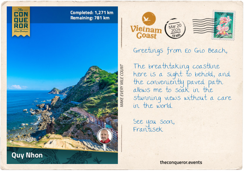
Even more captivating is the mountainous terrain surrounding these splendid beaches. The lush green hills and rocky outcrops provide a striking backdrop to the coastal scenery, creating a picturesque contrast between land and sea. I strolled along a cliffside path to Eo Gio, a sheltered beach with views of the rugged coastline and a popular destination for sunset watching. Between the sea breeze, crashing waves and the warmth of the sun, the walk was a pleasurable experience.
Next, I headed south to Bai Xep Fishing Village for its less-crowded beaches and a more laid-back experience. As I relaxed on the beach, watching the local fishermen hauling in the day’s catch, the anticipation of my upcoming seafood meal grew. I could already imagine the delicious flavours of a fish ball noodle soup (bun cha ca) or a crispy shrimp pancake (banh xeo tom nhay). With my taste buds tingling, it became clear that it was time to seek out a local eatery and savour some of the local versions of these culinary delights.
km od začátku : 1360
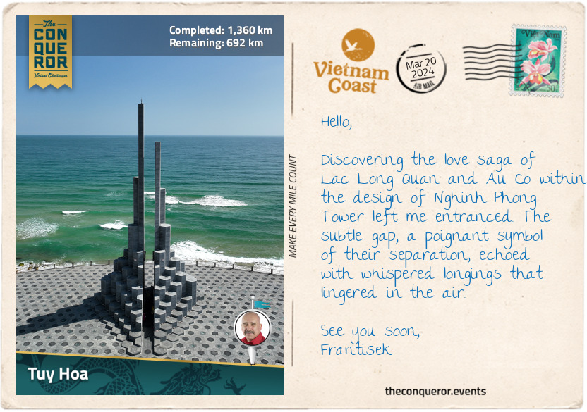
Tuy Hoa
Tuy Hoa is a beautifully laid out and well-organised coastal city with wide roads, clean sandy beaches and parks lining the shore. Along this shoreline stands the Nghinh Phong Tower, winner of the 2023 Asian Urban Landscape Award, closely resembling the interlocking basalt columns of Ganh Da Dia Beach, located approximately 15mi (25km) north of the city.
The architectural design was inspired by the legendary tale of Lac Long Quan and Au Co, featuring two stone columns measuring 115ft (35m) and 98ft (30m). Their story, one of love, yearning, honour and protection, serves as Vietnam’s creation story. Similar to the Māori creation story which started with Te Pō, the great nothingness, and the Japanese imperial line tracing its origins to a descendant of the sun goddess, Amaterasu, Vietnam's tale unfolds with the legend of the dragon king Lac Long Quan and the fairy princess Au Co.
Lac Long Quan, a brave warrior and the son of a mountain god (the father) and water dragon (the mother), safeguarded fishermen from giant fish monsters. Au Co, on the other hand, was a beautiful fairy from the mountains. Skilled in medicine and kind-hearted, Au Co travelled to heal the sick until she encountered a flying monster. Threatened, she transformed into a crane, catching Lac Long Quan’s attention, who swiftly destroyed the monster by tossing a huge rock. Falling in love, they married, united their kingdoms and lived between the mountains and the sea. Au Co later gave birth to an egg sac, from which 100 children were born, giving rise to the Vietnamese people.
Despite their deep love, Lac Long Quan and Au Co yearned for their respective homes. Unable to stay together, they parted ways, each taking 50 children to raise. The eldest son, King Hung, founded the Hong Bang Dynasty in 2879 BC, becoming Vietnam's ancestral ruler. The tower's structure encapsulates their story, with each column stacked with 50 stone blocks representing their children and the gap symbolising their separation. This gap, only wide enough for two people, creates a unique acoustic effect. As I stand within it, feeling the breeze flow through, I'm reminded of the soft murmur of wind, imagining Lac Long Quan and Au Co whispering longingly to each other.
km od začátku : 1448
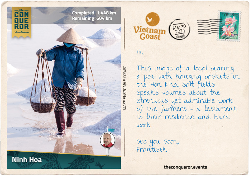
Ninh Hoa
About 8mi (13km) northeast of Ninh Hoa lies the Hon Khoi salt fields, where local villagers have been harvesting salt for generations. This was an intriguing place to explore and gain insight into the traditional salt production techniques.
Walking through the fields, I noticed the fields were divided into plots, with seawater channeled into these areas. When the seawater evaporates, fine salt crystals are left behind. The harvesting season is from January to June, during which farmers start their work before sunrise, spending up to seven hours each day under the scorching sun tending to the fields. Typically, women take on the role of harvesters, as the men are often engaged in fishing activities.
Salt harvesting follows a careful process. It relies on ideal weather conditions, preferably sunny and dry, to accelerate evaporation. It also involves closely monitoring salt crystal formation and concentration levels to ensure collection at the optimal point.
The actual harvesting is hands-on, using tools such as rakes or wooden implements to gently gather the salt crystals. The collected salt is either piled into small mounds or sent for further processing and refinement. This whole process spans several weeks from start to finish. It requires the expertise of salt farmers, who must determine the right time for harvest to maintain the salt's quality.
While Vietnam produces sufficient salt for its domestic market, local farmers are experiencing challenges from an influx of low-cost imported salt, making it difficult to maintain competitive prices.
km od začátku : 1497
Nha Trang
Nha Trang is a major fishing port and destination city, owing to its endless miles of stunning beaches framed by a picturesque promenade and swaying palm trees. The bay is a visual treat and a gateway to diving sites and nearby islands, such as the renowned Hon Mun Island. This island, Vietnam’s sole protected marine reserve, is a haven for diving and snorkeling enthusiasts.
While I may not fancy diving, my appreciation for aerial views found fulfillment on the Vinpearl Cable Car. Spanning an impressive 2mi (3.3km) over the sea from Phu Quy Harbour to Hon Tre Island, home to VinWonders amusement park, the cable car offered terrific views of the bay and the city.
Upon reaching VinWonders, the appeal of the amusement park unleashed the child within me. Wild water slide rides had me twirling and swirling, landing in the pools below with a big splash. The park was a delightful mix of architectural styles, from medieval castles to fantasy worlds and tropical paradises. Satisfied with the thrills, I explored the Garden of Five Continents, a botanical oasis showcasing plants from all over the world, including exotic plants and flowers from the South American jungle.
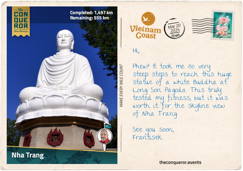
Back in the city, I strolled around Long Son Pagoda, a Buddhist temple set amidst a lush garden, followed by a hike to the summit of Trai Thuy Hill. Partway through the hike, I encountered a reclining Buddha, while at the top was another much larger Buddha seated on a lotus pedestal surrounded by trees and shrubs. I caught glimpses of the city skyline through the greenery.
I ended my day with a visit to the Alexandre Yersin Museum at the Pasteur Institute (his former office). Alexandre Yersin was a Swiss physician and bacteriologist who moved to Vietnam in 1891. He was known for introducing cinchona trees to the country. Native to South America, the tree’s bark was used by indigenous people to treat malaria, and it became an important component in the development of antimalarial medication. However, Yersing was most famous for discovering the bacterium causing bubonic plague. It was named Yersinia pestis in his honour. The museum, housing Yersin’s lab equipment, desk, and books, pays homage to his contributions and the Institute, still in operation, continues to produce vaccines and conduct medical research.
km od začátku : 1746
Mui Ne
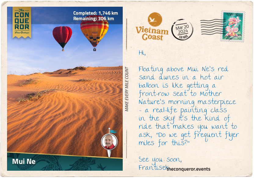
Much like the rest of Vietnam's stunning coastline, Mui Ne stands out with its impressive 12mi (20km) stretch of white sand, shaded by palm trees and surrounded by azure waters. It's a busy beach destination, with resorts and restaurants lining almost the entire shore.
But what really caught my interest in Mui Ne was a unique attraction just a bit inland – the vibrant sand dunes. These sand dunes, shaped by the wind and waves, come in two beautiful colors – gold and red. They're scattered all around, so I don’t have to go far to experience them.
The red sand dunes are right off the main road, and climbing up the hill offered a breathtaking view of the coastline and the sea. I could picture the dunes turning a fiery red at sunset. Ready for another sandboarding experience, I shot down the hill on my rented board, reveling in the exhilarating thrill that came with a few tumbles and sandy somersaults for good measure. However, the real exercise began when I had to trudge back up through the ever-shifting sand. With each step, my calves were having their own personal workout session – nature's way of keeping me on my toes, or rather, in the sand!
Next to the red dunes were the golden ones, looking like a vast desert – no need to go all the way to the Sahara when I had this easily accessible version! The best time to catch their golden glow was at sunrise. Since the middle of the day feels like standing on a giant stove, I planned a sunrise visit for the gold dunes and a sunset trip for the red dunes.
To spice up the adventure, cruising over the dunes on a quad bike not only saved me from some uphill struggles but also gave my calves a well-deserved break. And the pièce de résistance? A hot air balloon ride over the dunes because apparently, Mui Ne is the only place in Vietnam that thought, "Why not throw in a hot air balloon ride too?" I couldn't resist topping off the whole sandy escapade with a touch of airborne whimsy!
While these dunes offer loads of fun, they're not just for show – they play a vital role in protecting the coast from storms and erosion while offering a home to different plants and animals.
km od začátku : 1802
Ke Ga Cape
As I reached Ke Ga village, I took a slight detour to Ke Ga Cape, where Vietnam’s oldest and tallest lighthouse stands proudly on a rocky islet a mere 1,640ft (500m) from shore. A prominent local landmark, Ke Ga Lighthouse was constructed in 1899 by the French army to help ships navigate the huge boulders and rocky terrain scattered around this area. It stands tall at 213ft (65m), featuring a distinctive octagonal design carved from granite blocks.
Keen on strolling to the lighthouse, my plans hit a snag when, instead of low tide, the tide had other plans. Rather than attempting a wet walk, I had to turn back, find a nearby boat operator, and decide whether to quickly get there on a motorboat or slowly cruise across a uniquely Vietnamese basketboat.
Never short on wanting adventure, I settled for a laid-back sail in a basketboat. Also known as coracles or thuyen thung in Vietnamese, these boats are unusual traditional watercraft found primarily in the coastal regions of Vietnam. Constructed with bamboo frames and woven with water-resistant materials like bamboo skin, these boats, measuring 4-6ft (1.2-1.8m) in diameter, have a round or oval shape resembling a basket. They are used for fishing in shallow waters or navigating narrow channels.
But why were they made this way? Well, when the French colonists wanted to charge taxes on boats, the fishermen couldn't pay. So, they changed the design to look like baskets instead of boats. This way, they didn't have to pay taxes because the new design didn't match what the tax covered.
Building basketboats demands skilled hands and technical weaving expertise. Maneuvering these boats isn't exactly a piece of cake either, given their conical shape. It requires serious training to handle them effectively. So, when I enthusiastically hopped into the rented basketboat for a ride to the islet, I crossed my fingers and silently hoped for a graceful sway instead of an unintentional somersault into the sea.
Having safely arrived on the islet, I ventured up to the tower, bravely tackling the dizzying 183-step circular stairway to the top. The reward? An incredible view of the South China Sea and the picturesque coastline. The idea of an overnight camp added to my excitement, with the promise of a front-row seat to the sunrise the next morning.
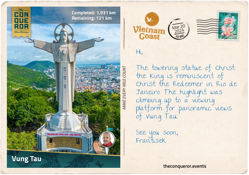
km od začátku : 1931
Vung Tau
As I was nearing the end of my journey, I took the time to explore the coastal gem of Vung Tau, a city perched on a peninsula known for many stunning beaches with names as memorable as Pineapple Beach and Strawberry Beach. Strolling along, I learned that in the 14th and 15th centuries, this very area was a swamp visited by European trading ships, giving birth to the city’s name Vung Tau, which means "anchorage."
Setting foot on Back Beach, a quaint sandy spot with a charming park, I tossed off my shoes, let the sand squeak between my toes, and watched the water gently lapping at the edge. On the flip side of the peninsula and in contrast to Back Beach, lies Front Beach, bustling with activity, a busy thoroughfare, towering hotels, and, for the adventurous, the perfect spot for kitesurfing.
Venturing southward, I discovered Hon Ba, a small rocky island standing 720ft (220m) offshore. Its centrepiece, occupying almost the entire island, is the Mieu Ba temple, a place of worship revered by the locals. To my delight, and unlike Ke Ga Cape, it was low tide. A rocky path emerged, connecting the island to the mainland, which I had the pleasure of walking across to explore the island.
From Hon Ba, my gaze was drawn to the large Christ the King statue atop Small Mountain, visible in the distance. The mountain boasts two peaks, one featuring the iconic statue and the other hosting a lighthouse. Intrigued, I left the island to go and explore the mountain. First, I had to tackle the challenging ascent as I conquered the 850 steps to the summit. But it was worth it for the uninterrupted views of Vung Tau’s skyline and the grand statue. The statue was built in the 1970s by the local Catholic community, and it stands 105ft (32m) high and 60ft (18m) across the outstretched hands. Inside the statue was an additional 133 steps that led me to a viewing platform at the back of the statue’s shoulders, offering a closer look at this impressive monument.
My journey concluded at Nghinh Phong Cape, the tip of the peninsula, where a rugged landscape and a hiking trail awaited. It seemed like an ideal spot for a sunset, where the gentle breeze created a peaceful atmosphere. As the sun set over the horizon, I contemplated the last stretch of my journey to Ho Chi Minh City.
km od začátku : 2052
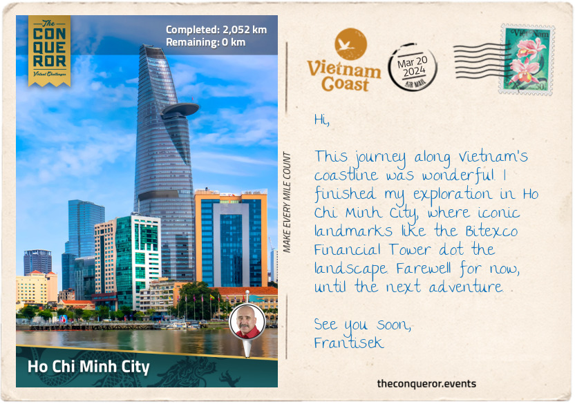
Ho Chi Minh City
As I reached the final stretch of my journey and entered Ho Chi Minh City, formerly known as Saigon, I found myself in the heart of the metropolis. The Sai Gon River, the city's primary water source and home to the Port of Saigon, gently meandered around the city before merging with the Dong Nai River southeast of downtown. While walking beside the river, I marvelled at the skilled maneuvres of motorcycles navigating the bustling traffic, seamlessly weaving between cars and lanes like seasoned motorbike racers. The city's skyline stretched before me on this sunny day, the sky clear and cloudless.
Passing a major intersection, I caught sight of the Bitexco Financial Tower, previously mentioned in my journey, its architecture inspired by the bud of a lotus flower. Its glamorous and modern design, complete with an observation deck, contrasted with the surrounding colonial-era buildings. Continuing my exploration, I reached the Tran Hung Dao Statue – positioned amidst a semi-circular moat and a park – a tribute to the 13th-century military leader who successfully defended Vietnam against Mongol invasions.
Moving from the statue, I made my way to Duong Nguyen Hue, a 210ft (64m) pedestrian boulevard extending 2,198ft (670m) through the city centre. It is lined with trees, fountains, and public art installations and serves as the city's social hub, frequently hosting large-scale events. Further along the boulevard, I came across the Music Fountain, featuring a stunning pinkish-red lotus glass sculpture as its centrepiece, surrounded by sprinklers. In the evenings, it transforms into a water and light show, occasionally accompanied by music.
My journey concluded at the city hall. French architects constructed it in the early 1900s, bearing a striking resemblance to Paris City Hall. The building, with a central clock tower and turret-like roofs, spans 262ft (80m) in length. A statue of Ho Chi Minh graces the front of the building. After the reunification of Vietnam in the late 20th century, the building became the headquarters of the Ho Chi Minh People’s Committee.
Eager to savour a fresh bowl of pho and crispy spring rolls, I am off to find a local food stall. Then, I’ll take a moment to not only digest the local flavours but also to reflect on my coastline journey from Hanoi to Ho Chi Minh City. See you next time.