I once asked a Welshman how he would describe the Wales Coast Path. He said, "… it's got a dramatic coastline, with jagged cliffs, choppy seas, stacks, caves and large sandy beaches mixed in with rolling hills, dense woodland, isolated farmhouses and ancient churches". Never mind the myriad of medieval castles and quite a few listed as UNESCO sites.
As you might imagine, my interest was piqued, and I wanted to explore, see it with my own eyes, walk the coastline, and enjoy the landscape's wildness while embracing its tranquility.
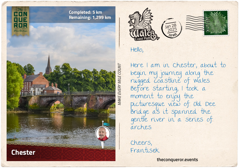
Wasting no time, I arrived in the historic city of Chester, where the River Dee gracefully meanders through the landscape to find its way to the Irish Sea. Located in England, close to the English-Welsh border, Chester was founded in the first century as a Roman fort named Deva Victrix. Its Roman heritage is still evident in the grid pattern layout and the fabulous and well-preserved city walls, a 2mi (3.2km) circuit around the city centre. Strolling the walkway gave me a lovely elevated view of the city, along with exploring the tower ruins and gates.
A distinctive feature in Chester is the Rows, a medieval-era two-tiered shopping and dining gallery. The architecture is Tudor and Jacobean, easily recognised by the black and white half-timbered facades and ornate carvings. With its long history, Chester has evolved through many architectural periods, from the Gothic grandeur of Chester Cathedral, Georgian townhouses, and Victorian influences to the contemporary buildings dotted amongst them.
A historic landmark near the city centre is Chester Castle, the 11th-century stronghold ordered by William the Conqueror shortly after the Norman Conquest of England in 1066AD. Over time, it saw modifications and expansions, including the construction of a stone keep by King Henry II. The castle played a role in the English Civil War and later evolved into a courthouse and administrative centre.
Since the castle was not accessible to the public, I made my way to the start of my Wales Coast Path journey. I crossed the border into Wales and found myself alongside River Dee, where a marker consisting of two stone pillars launched me into a long-distance journey of 810mi (1303.5km) from Chester to Chepstow. The route is linked by several independent trails running on or close to the coastline. Only very few of them head inland. As a matter of fact, this entire route is the only one in the world that has a continuous waymarked path around its entire coastline.
As I begin to tackle this dramatic coastline, I will remember the Welshman's words and look forward to its many wonders.
km od začátku : 0037
Talacre
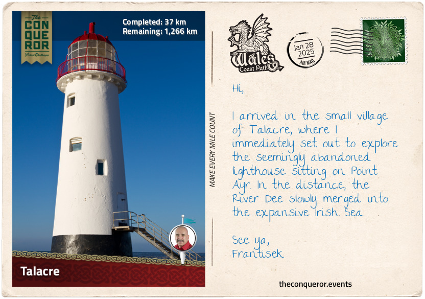
I crossed the River Dee near Queensferry and continued on its southern side until I reached Point Ayr, the northernmost point of Wales. It is located at the mouth of the River Dee, which flows into the Irish Sea. The picturesque beach is part of Talacre, a small village favoured by locals and tourists for its long sandy beaches and extensive sand dunes.
The dunes support a wide variety of plants and animals, and due to their ecological importance, they are designated a Site of Special Scientific Interest (SSSI). Plants such as marram grass and sand sedge help to stabilise the dunes, whereas the sea holly, with its blue-green leaves and silver-blue flowers, and bird's foot trefoil, with clusters of yellow flowers, bring a splash of colour.
The very rare Natterjack toad, with its distinctive yellow stripe down its back, makes this area its home. Extinct in Wales by the 20th century, the toad was reintroduced as a protected species. If I gingerly search within the sand dunes, I may chance upon a skylark nesting, trilling its melodious songs. At the same time, I may spot the odd bird of prey up in the sky, be it a kestrel or a peregrine falcon.
Perhaps the most notable landmark on the beach is the Talacre Lighthouse, also known as the Point of Ayr Lighthouse. This 1776 lighthouse, standing atop the sand dunes, was built to guide ships navigating the coastline. Later, a pile lighthouse was established in its place by the Trinity House, an organisation responsible for overseeing lighthouse operations across Wales, England, the Channel Islands, and Gibraltar. By the end of the 19th century, this replacement, too, gave way to a lightship. Today, Talacre Lighthouse stands in solitude, a somewhat forsaken sentinel, steadfastly gazing over the expanse of the Irish Sea.
km od začátku : 0076
Llandudno
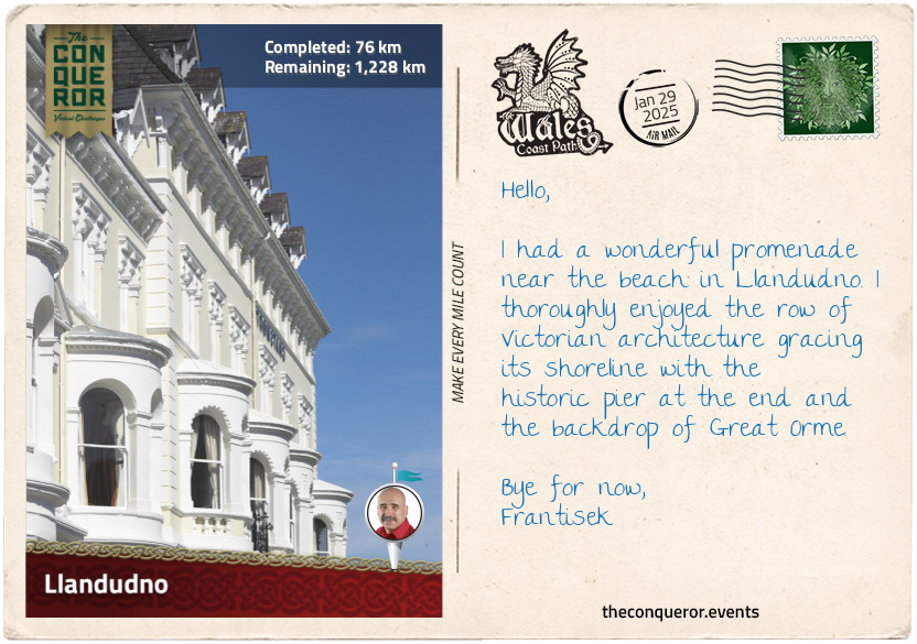
Llandudno is a delightful coastal town flanked by two sandy beaches and the massive limestone Great Orme headland to its north jutting into the sea. As the largest seaside resort in Wales, it is often referred to as the "Queen of the Welsh Resorts".
The town's architecture evokes its Victorian past when it became a fashionable seaside resort. The beautiful curve of Orme Bay and the incredible Llandudno Promenade, lined with pastel-coloured Victorian-era hotels, guided me to the waterfront, where I took a leisurely stroll along the historic pier, exploring charming shops and amusement arcades. Seated outdoors at the pier's end, I found the perfect spot for a pot of tea. I savoured a cup on a crisp, sunny day, relishing the sea breeze on my face while hearing seagulls squawking above.
A growing interest in health and wellbeing during the Victorian era drew many people to the town's coastal shores, believing that its clean air and clean waters gave it a therapeutic quality. Construction of the North Wales Coast Railway greatly improved accessibility to Llandudno from cities such as Manchester and Liverpool, giving people a much-needed respite from congestion and pollution.
Llandudno's reputation was further elevated when Queen Victoria visited North Wales in 1859. When Elisabeth of Wied, Queen Consort of Romania, left town following a stay of five weeks, she described Wales as "a beautiful haven of peace".
The majestic Great Orme is the main focal point as it towers over the town, commanding attention and inviting any explorers to hike its trails to the summit for a panoramic view of the Irish Sea. For a more leisurely approach, Great Orme Tramway from the town's centre is a fun ride straight up to the summit, or the Llandudno Cable Cars offer an alternative fun aerial trip to the top.
Once on top, the gorgeous views extend across the Irish Sea as far as the eyes can see, encompassing the Little Orme, the craggy headland opposite the bay, and the renowned Snowdonia Mountains.
For a whimsical experience, I searched for the Alice in Wonderland statue trail, consisting of a series of bronze sculptures such as Alice herself, the White Rabbit, the Mad Hatter, the Cheshire Cat, and the Queen of Hearts. The connection between Lewis Carroll's famous novel "Alice in Wonderland" and Llandudno resides with eight-year-old Alice Liddell, who spent her first of many summers in town and inspired the author's tale of curious adventures down the rabbit hole.
Llandudno was a charming place to while away some time, promenading the foreshore, hiking to the summit, and simply taking in the splendid sites.
km od začátku : 0089
Conwy
With great anticipation, I crossed the bridge over the River Conwy, where the National Trust's Telford Suspension Bridge is situated parallel. This gothic-style 1800s bridge was designed by the renowned Scottish civil engineer and architect Thomas Telford. He was a pioneer in the early development of infrastructure and transportation systems during the Industrial Revolution, having been at the forefront of many projects such as the Caledonian Canal in Scotland, the Pontcysyllte Aqueduct and Port Penrhyn in Wales while improving and expanding Britain's road network.
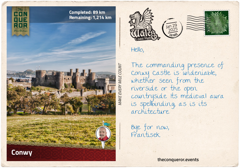
The suspension bridge led directly into the formidable medieval fortress, Conwy Castle. Standing guard over the River Conwy and the seaside town of the same name, the castle watched over this important river route that led into the heart of Wales. Built by King Edward I on his quest to conquer the last of the Welsh territories, the Kingdom of Gwynedd, the castle is one of a long chain of fortifications. Edward strategically erected nine castles around Gwynedd, encircling the northwest of Wales and establishing control. This collection of castles earned the nickname "Ring of Iron".
Conwy Castle is an impressive fortress featuring eight huge towers with arrow slits for defense and a thick curtain wall connected to a one-mile (1.6km) town wall that is still remarkably well-preserved. On the upper exterior walls near the battlements are the remains of drop boxes (formally known as machicolations) where stones or other materials would be dropped on attackers. The main gate was via a drawbridge but is now long gone. With its near-oblong shape, the narrow ends of the castle had barbicans added for extra defense. Inside, the Great Hall used by the king for entertainment was supplemented with various other spaces that helped the castle function, from a cellar and kitchen to stables and blacksmith to a royal residence, chapels and, for the unlucky, a prison tower.
An interesting feature of Conwy Castle is the absence of a central keep that usually contained the royal apartments. The reason is a change in layout design focused on defense strategies, where strong walls and layered defenses became a priority after factoring in the rugged terrain, as opposed to a single central stronghold. This allowed for better protection and control of the surrounding area.
As the centuries passed, Conwy was besieged in the 15th century, when Welsh leader Owain Glyndŵr rose against English rule, wanting to reassert Welsh independence. Another two centuries later, the castle was entangled in the English Civil War, where it was held by Royalist forces and besieged by Parliamentarian troops. Following the war, the castle was partially slighted, stripped of its iron and lead, turning it into a ruin. Neglect set in until the 19th century, when restoration efforts were initiated to preserve its history.
Today, the castle maintains its vigil over the river's banks. The medieval setting harmoniously coexists with the presence of roads and railways. In 1986, Conwy Castle and three other "Ring of Iron" castles were designated UNESCO World Heritage Sites.
km od začátku : 0127
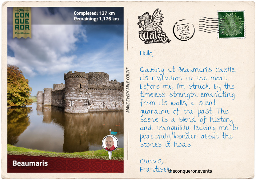
Beaumaris
Beaumaris is a small, charming town on the island of Anglesey in Wales. It is set at the eastern entrance to the Menai Strait, a tidal waterway that separates the island from the North Wales coastline. Historically, Anglesey, known as Ynys Môn in Welsh, was part of Gwynedd, a medieval Welsh kingdom, and is now a county northwest of mainland Wales.
The town's history traces back to the mid-9th century when Vikings established a presence in Gwynedd through conquest or trade. Initially focused on raids for resources, the Vikings eventually settled more permanently. Gwynedd's access to the sea easily facilitated Viking navigation, while fertile farming soil supported the settlers' needs. At that time, Beaumaris was known as Porth y Wygyr, translating to "Port of the Vikings".
The Norman invasion of Britain in the late 11th century significantly impacted Anglesey. Given Anglesey's strategic location, it became a target for Norman expansion. Castles were constructed along its coastline, creating a network of fortifications to establish authority, safeguard its borders, and protect newly acquired territories.
However, it wasn't until the late 13th century, after the conquest of Wales, that Edward I ordered additional fortifications as part of the "Ring of Iron". Beaumaris Castle was the last of the royal strongholds, planned to be the crowning glory, built with near-perfect symmetry. Partially surrounded by a moat, the castle has a concentric design with dual layers of walls and defenses bordering a central courtyard. This layout protected against attackers and contributed to the castle's strength. However, the castle was never completed, partly due to financial constraints and changing priorities. Beaumaris Castle joins Conwy Castle as the second UNESCO World Heritage Site in the “Ring of Iron”.
The town's story was shaped by the royal charter granted by Edward I, giving civic rights to English and Norman-French residents while limiting the rights of the Welsh. The charter prevented the Welsh from holding government roles, owning property, and engaging in certain trade activities. The town's architecture showcases landmarks like Tudor Rose, the town's oldest timber-framed building dated around 1480, the stylish 15th-century interiors of The Bull's Head Inn, and the distinctive hexagonal design of 19th-century Beaumaris Gaol, intended for more effective inmate supervision.
To complete my exploration of Beaumaris, I strolled down to the beach and onto the pier that once served as a docking point for 19th-century steamships. As I stand at the pier's edge, gazing out to sea, I envisioned the arrival of Viking ships centuries ago—whether for trade, raiding, or settlement—each visit carrying an air of anticipation and uncertainty.
km od začátku : 0222
Holyhead
Heading north from Beaumaris, I followed the Anglesey Coastal Path, part of the larger Wales Coast Path to Holyhead. It is located on Holy Island on the northwestern coast of Anglesey. This small coastal town is positioned directly across from Dublin. Being the shortest and safest route to Ireland across the treacherous Irish Sea, the town has become an important route for transporting goods between Ireland and England. With its straightforward sea crossing, the port has a busy maritime traffic. For context, up until the end of 2020, over 450,000 trucks used the ferry services to cross the sea.
Behind the ferry terminal stands Skinner's Monument, commemorating Captain John M. Skinner. He was an American who lost his arm during the Revolutionary War and an eye when he was a child. When he left the Navy, he moved to Holyhead to work as a captain on mail boats. He was a colourful character, fondly remembered for his kindness and generosity, who would walk around town with his pet raven like a pirate with his parrot. A fearless sea captain, he was remembered for successfully bringing a ship into the harbour while navigating rocks and small islands during rough weather conditions. This was nearly three-quarters of a century before the Holyhead Breakwater was constructed, necessitated to overcome the northerly winds that would prevent ships from safely reaching the harbour. As a side note, the breakwater, at 1.7mi (2.7km), is the longest in the United Kingdom.
His stories of bravery, service and charity are captured in the Holyhead Maritime Museum, where Captain Skinner, dressed in uniform, is immortalised in a life-size model along with his pet raven. On the wall hangs a painting by his friend James Sparrow, capturing his house and local friends.
In the town centre was the 13th-century St. Cybi's Church, dedicated to the patron saint of Holyhead. Founded by St. Cybi in the 6th century, the site housed a clas, a Celtic Church with monastic and educational aspects. The church was built inside a Roman fortification called Caergybi, the Welsh name for Holyland, with three walls and the fourth being the sea. This was a unique feature and one of very few in Europe. The current church, dated to the early 16th century, has a painting inside near the organ depicting the Tudor rose, a symbol of the royal Tudor family who were of partial Welsh descent.
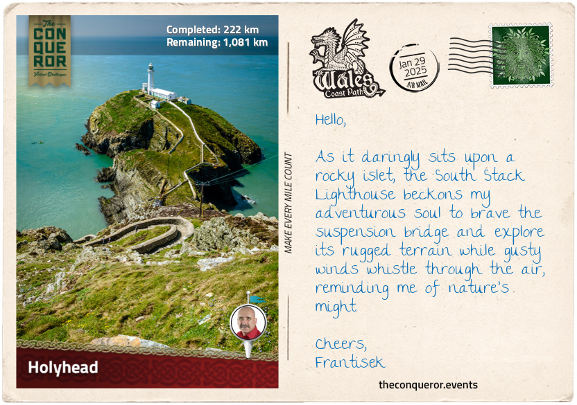
Continuing around the coast, I hiked past Holyland Mountain and came upon South Stack. It was a small rocky island just off the coast accessed via a suspension bridge. The island is largely known for its lighthouse, built in 1809 to guide ships through the hazardous sea. I took the well-paved path up to the lighthouse for a panoramic view. During nesting season, the island is home to various species, including puffins, razorbills, guillemots, and kittiwakes.
I will take some time to explore while enjoying the rugged cliffs, wild sea and coastal scenery. The next stop will be Caernarfon.
km od začátku : 0330
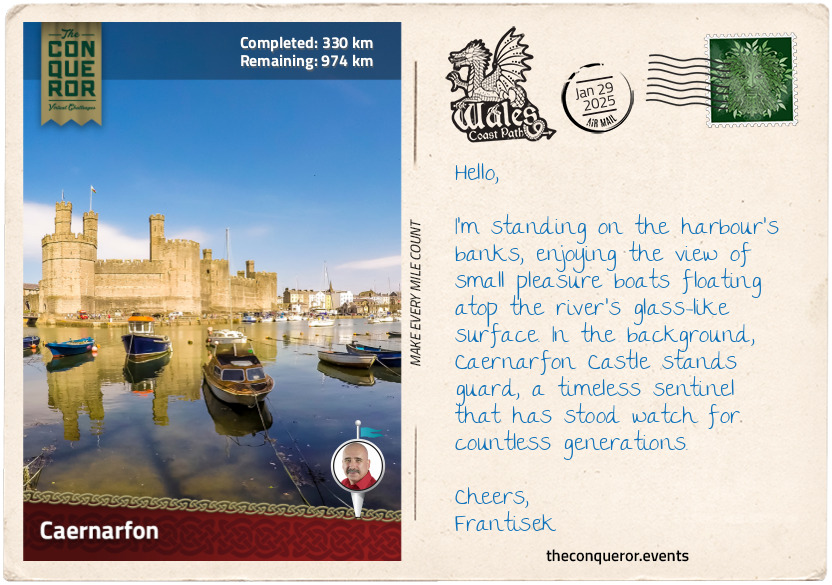
Caernarfon
Returning to the mainland, across the Menai Strait, I arrived in the royal town of Caernarfon. Rich in natural resources, Caernarfon was occupied by the Celtic Ordovices tribe. When the Romans invaded Britain, they built the fort Segontium to control the Celts. After the Romans' departure three centuries later, Caernarfon joined Gwynedd. William the Conqueror's attempt to invade the town in the 11th century by building a motte-and-bailey castle failed. This was largely due to the rugged terrain and logistical difficulty, further hampered by limited resources and local resistance.
The town remained independent until Edward I's conquest of Wales in the 13th century, when he promptly built Caernarfon Castle as part of his "Ring of Iron" chain of fortifications. While visiting the castle, Edward's wife, Eleanor of Castile, gave birth to an heir, Prince Edward. At age seven, the young Edward was bestowed with the title of Prince of Wales. This tradition continues today, with Prince William as King Charles III's eldest son carrying the title.
Building the castle took nearly fifty years, with the works progressing in stages. Once completed, it was the largest and most formidable fortification in Wales. The castle's layout was driven by the lie of the land, ending up as a figure-eight narrow enclosure. It was dotted with multiple towers along its curtain wall and a drawbridge at the King's Gate, the main entrance from town. A wall encircling and connecting the town to the castle walls was built to extend its defensive structure. In 1284, Caernarfon effectively became the capital of north Wales and the seat of the English government.
Tensions continued between the English and Welsh, with revolts erupting over the following centuries until the accession of the Tudor House to the throne in 1485, who were of Welsh origin. The castle's importance waned as hostilities eased with the Tudor's rule. Consequently, it suffered neglect, with its domestic buildings stripped of valuables and the roofs and timber decaying. Major repairs and conservation efforts began in the 1870s to restore the castle. Caernarfon joins Beaumaris and Conwy as the third property in the "Ring of Iron" to be added to the World Heritage Site register.
The town maintains much of its medieval roots in both layout and preserved sections of the town walls. With a high concentration of Welsh speakers, the culture is actively nurtured and illustrated in its bilingual street signs.
After a leisurely stroll to the waterfront, I took in the lovely view of Anglesey across the strait before gradually departing the town along the waterside to resume my journey.
km od začátku : 0360
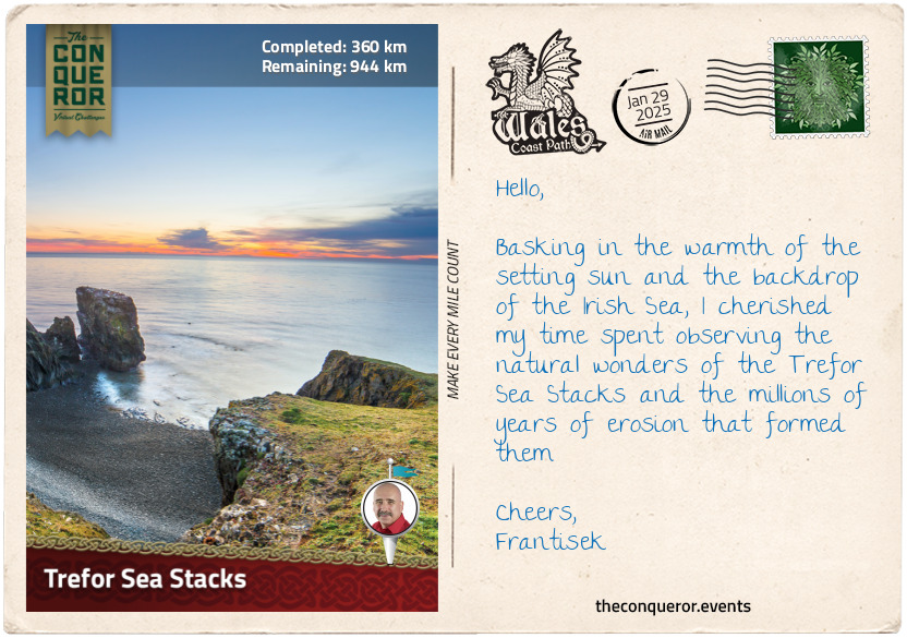
Trefor Sea Stacks
Leaving Caernarfon behind, I crossed the harbour bridge and set off on a path leading along the coast on a well-paved minor road toward the Trefor Sea Stacks. Menai Strait and the island of Anglesey stretched before me toward the narrow channel of Abermenai. On its south side, situated on the tip of Dinlle Peninsula, is the 18th-century Fort Belan. It is the only British fortress from the American Revolution, purposely built by Thomas Wynn, the region's Member of Parliament who was concerned about attacks on the British coastline. The channel it guarded was a mere 115ft (35m) wide; however, the fort never saw any serious action, and the Wynn family later turned it into private property. Today, it's an accommodation complex where guests must be mindful of the incoming tide as the property gets cut off from the mainland twice daily.
As I continued along the coastal path, I came across St Baglan's church standing alone in a large field, bound by a low stone fence, towering trees to one side and a small time-scarred cemetery. The aged interior illustrated the social life in the 18th century with modest timber pews at the rear and the grander box pews reserved for the wealthy villagers. An oddity among the weathered gravestones was the modern headstone for the 1st Earl of Snowdon, dated 1930-2017. Piquing my curiousity, I was surprised to discover that he was a renowned photographer and filmmaker who campaigned tirelessly for disabled people and was once married to Princess Margaret, Queen Elizabeth II's younger sister.
My path led me to Dinas Dinlle, where I ascended to the hilltop to take in the view that lay ahead. The next stretch of the journey was less than captivating, navigating a narrow road that occasionally grew busy with traffic, which became even more mundane when I turned onto the A499 and followed the cycle path to Clynnog Fawr.
The old pub at Clynnog Fawr has long gone, but I welcomed a brief rest at the café in this small village. The town's main feature was the Eglwys Beuno Sant, a church dedicated to Saint Bueno, who on this site established a Celtic monastery in the early 7th century. Bueno is said to have descended from the Royal Princes of Powys. They were Welsh nobles ruling Powys' central and eastern territories in present-day Wales. The monastery was destroyed by Vikings and then again by the Normans. The current church is a major stopping point for the North Wales Pilgrimage Way, which merges temporarily with the Wales Coastal Path.
My journey finally turned off the A499, and I returned to quiet country roads. Nearing a small gate, I crossed a small wooden bridge and walked near the coast's edge but not too close since there was no fence for protection, and the drop was straight into the ocean. Before long, the Trefor Sea Stacks came into view. Three stacks of different heights and shapes rose above the surprisingly calm, clear water. There was no wind this time, unusual for the coast, allowing me to take the time to admire the volcanic-like jagged piles of rock. Perched atop one of the stacks were a flock of seagulls seemingly resting, perhaps looking out for their next feed.
With these opportunistic feeders, I decided against having my snack. I chose instead to savour a hot cup of tea from my thermos.
km od začátku : 0505
Harlech
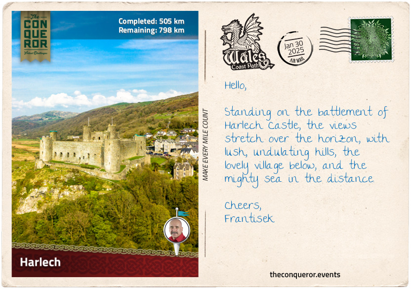
As I arrived in Harlech, I looked forward to exploring the fourth and final castle designated a UNESCO site as part of the "Castles and Town Walls of King Edward in Gwynedd". There in the distance looming over the town from its rocky knoll was Edward's fortress, Harlech Castle. Built around the same time as Conwy and Caernarfon, Harlech's somber greyish stronghold comes with a turbulent past.
Strategically located overlooking the Irish Sea, the castle's curtain wall is still visible in parts as it stretches down the slope to what once used to mark the sea's shoreline. In the medieval days, the Irish Sea was much closer to the castle than today, allowing it access to be resupplied by sea during sieges. However, centuries of sediment deposit and land reclamation altered this coastal area, shifting the shoreline away by half a mile or so (800m).
Harlech Castle played major roles in conflicts such as the English Civil War (1642-1651) mentioned previously and the Wars of the Roses (1455-1487), where two royal houses, the Lancasters and the Yorks, fought for the English throne. The victorious Lancastrians formed an allegiance with the Yorks via marriage. Combining the two houses gave rise to the Tudor dynasty, known for royals such as King Henry VIII and Queen Elizabeth I.
One of the most famous episodes in the castle's history is the Welsh rebellion led by Owain Glyndŵr in the early 1400s. Proclaiming himself Prince of Wales, he laid siege to Harlech Castle and successfully captured it. Owain used the castle as his residence for four years until it was besieged in return, and the castle fell due to a shortage of supplies.
Outside the castle wall, on a small patch of grass, is a bronze sculpture called "Two Kings". The statue of a horse and rider carrying a young boy shows a touching scene from an old Welsh story collection called the Mabinogion. This story is about Bendigeidfran (Bran the Blessed), a giant and king of Britain, and his sister Branwen, who married Matholwch, king of Ireland, as a symbol of peaceful relations between the two countries.
Setting sail from Harlech, the newlyweds returned to Ireland, where their son Gwern was born. Not all was well in the kingdom, and after a few years, things began to unravel. Branwen was expelled from court, sent to the kitchen to work and mistreated. Seeking assistance from her brother Bran, he soon crossed the sea with an army ready to save his sister. Treachery on both sides ensued, and in the process, Gwern was killed. A fierce battle erupted, ending with only seven survivors. Bran died from a poisoned arrow, and Branwen, devastated by her losses, died of grief.
Circling back to the statue, it represents the emotional weight Bran, as the rider, had to bear while carrying the lifeless body of his nephew Gwern. The story is meant to be a reminder of the price of conflict and how important it is to find peace.
km od začátku : 0605
Aberystwyth
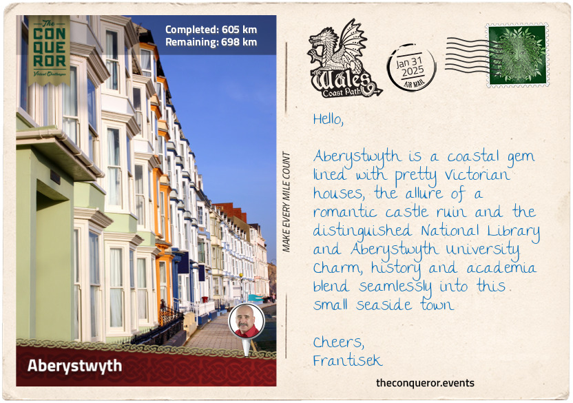
Aberystwyth is a charming seaside town. Located on the shores of Cardigan Bay, its waterfront is lined with Victorian-era townhouses. As I explored the town and took a walk on the beach, I caught sight of the railway track ascending a hill at its northern end. Curious, I ventured toward it to discover it was a historic funicular built in the late 19th century for an easier hilltop journey. I hopped aboard and settled into it, waiting for its slow, rumbling ascent up the hill. A gorgeous view of the town awaited me at the top, with the nearby café tempting with delightful treats and a hot drink.
Returning to town, I strolled to its south side, where the ruins of Aberystwyth Castle stood. As one of the Ring of Iron castles built by Edward I, it was briefly held by Welsh leader Owain Glyndŵr. During Charles I's reign in the 17th century, it became a branch of the Royal Mint, producing silver coins sourced from local mines. Parliamentarian troops razed it during the English Civil War. While strolling the castle walls, I stumbled upon an unexpected treasure—a series of ten mosaics recounting the castle's history, including the remarkable discovery of a well-preserved skeleton in 1988. Its incredible condition perplexed scientists, considering the acidic nature of Welsh soil and its typical degradation of organic matter. The scientists could only hypothesise that the limestone used to build the castle helped preserve the skeleton. Today, it is displayed in the local museum.
However, a peculiar sight on the castle grounds was the arrangement of 13 stones forming a circle. Placed in 1915 during the Welsh National Eisteddfod, these stones represented the country's 13 counties at that time. The Eisteddfod is an annual cultural festival celebrating the Welsh language, literature, music, and the arts through competitions and performances. Gorsedd of Bards is at its centre, a group honouring individuals who have made important contributions to Welsh culture, language, and the arts.
My final stop was at the National Library of Wales, the country's repository for all publications related to the nation and its culture. It is the largest library in Wales, holding more than 6.5 million items. One of its founders, Sir John Williams, preferred the library to be in a more central and Welsh-speaking part of Wales as opposed to Cardiff, where the main institutions are located. Aberystwyth was chosen as the site for the library because it is accessible from anywhere in Wales and has a reputation as a university town with a strong academic atmosphere. The library is a hub for research, education, and preservation of all things Welsh.
My next destination is New Quay, further south of Cardigan Bay.
km od začátku : 0644
New Quay
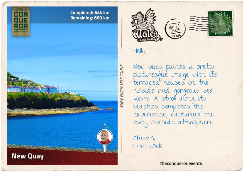
New Quay is a small seaside resort nestled between lush green rolling hills in a sheltered part of Cardigan Bay. The town boasts several long sandy beaches and a natural harbour. It was once home to a thriving fishing fleet. Sometime in the early 1800s, shipbuilding became a new industry, constructing schooners sailing the coastline and larger vessels crossing the ocean. The port operations expanded, providing logistical services for cargo movement, further bolstering the local economy. The town grew with terraced houses springing up along the bay's slopes.
Like many coastal towns during the age of piracy, New Quay was notorious for its smugglers. Ships filled with contraband would moor off the coast, and at night, small boats would row to collect the illegal cargo. Renowned pirates like Bartholomew Roberts (aka Black Bart/Barti Ddu), Henry Morgan and John Evans hailed from Wales. Roberts was perhaps the most successful during the Golden Age of Piracy, capturing over 470 prize ships in a career that spanned only three years. He also created his own pirate code and was among the first to use a Skull and Crossbones flag variant. He died in battle, effectively marking the end of the Golden Age of Piracy.
Henry Morgan was both a pirate and a privateer. The British Crown hired him during the 1600s to take on the Spanish in times of war. Arrested and later acquitted, Morgan was knighted and became Governor of Jamaica, where he spent the rest of his life.
John Evans was a seaman working out of Jamaica. He turned to piracy when he lost his job and had no further prospects. Evans started by raiding wealthy Jamaican houses and then shifted his focus to capture Spanish galleons. Despite his successful plundering career, it was short-lived due to a fatal gunshot wound sustained in a duel.
However, in modern times, New Quay is closely associated with Welsh poet Dylan Thomas. His most famous work is a play called "Under Milk Wood", largely drafted while he lived in town toward the end of World War Two. Thomas was often characterised as a tormented and troubled writer. Those who knew him expressed that his time in New Quay was his most productive period, where he found inspiration in the local surroundings and the community.
To quench his thirst, Thomas preferred the Black Lion pub in town, as noted by the sign outside the building saying it was his "favourite watering hole". This is likely true since he referenced the pub in some of his works. I thought it was an ideal place to stop for lunch and refreshments while enjoying the views across the bay.
km od začátku : 0726
Fishguard
Heading toward Fishguard, the trail led through an archway into Fishguard Fort. This military site was associated with the Battle of Fishguard when a small French force landed in the bay attempting to invade in 1797. Local militias, armed volunteers, and British Army units defended the area and defeated the French. The story of this invasion was beautifully depicted in the Last Invasion Tapestry, a huge embroidered tapestry initiated as a community project. Over four years, eighty local women worked together to complete the tapestry in time for its bicentenary commemoration in 1997. Measuring an incredible 100ft (30m) long and 21in (53cm) wide, the tapestry’s stitching style resembles the famous Bayeux Tapestry, which chronicles the story of the 1066 Norman Conquest. A total of 178 shades of wool were used to create subtle colour changes illustrating different times of the day and the seasons.
A notable figure during the Battle of Fishguard was Jemima Nicholas (aka Jemima Fawr), a Welsh local who, armed with a pitchfork, captured 12 French soldiers. According to folklore, she led a group of local women armed with household items like pitchforks, scythes, and brooms to confront the soldiers. Rounding them up, the women locked them inside the church until the French troops surrendered shortly afterward. Jemima and her group of women are featured in the Last Invasion Tapestry, and her tombstone in the local cemetery is inscribed with her heroic act.
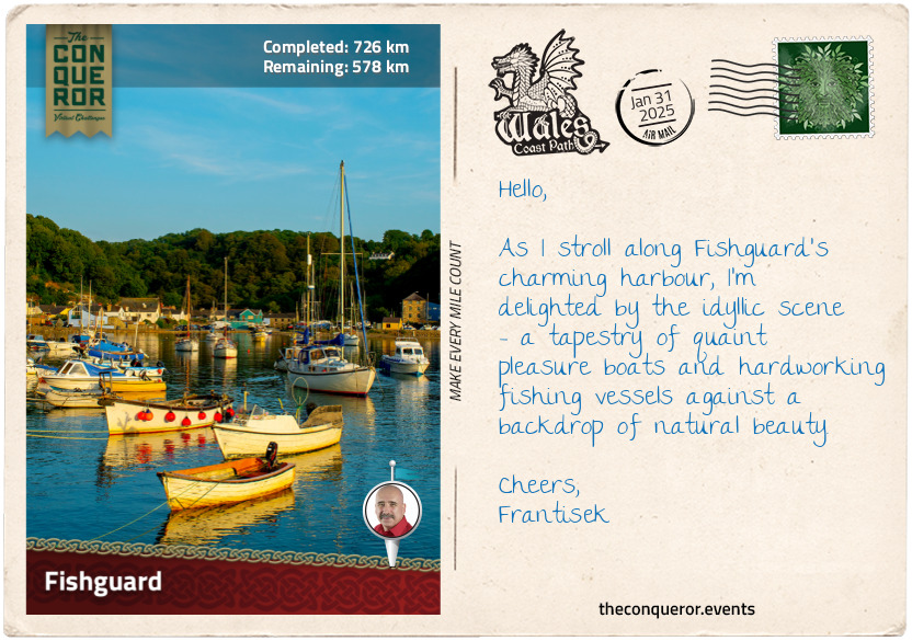
Fishguard is a coastal town with a strong maritime heritage, where fishing was the primary industry, trading with Ireland and England. Located in a deep valley at the confluence of the River Gwaun and the sea, the town stretches up the valley’s slope and down to the shores of Fishguard Bay. The bay acts as a natural barrier, protecting the town from the fierce waves of the Irish Sea and the prevailing westerly winds.
However, the bay could not shield Fishguard in 1779 when Irish privateer Luke Ryan bombarded the town because it refused to pay a ransom. Ryan was commissioned by the French, who supported the Americans against the British during the Revolutionary War, to command the ship “Black Prince”. He was authorised to target British vessels and disrupt their trade and naval activities. Interestingly, while Ryan's actions may resemble piracy, he operated within the legal rules of privateering during wartime. Whether burning the town was an act of piracy or privateering remains questionable.
It was after Ryan’s attack that the fort was built, which proved valuable when the French arrived nearly two decades later.
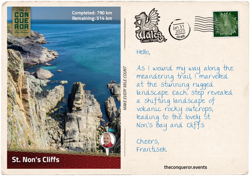
km od začátku : 0790
St. Non’s Cliffs
Having left Fishguard, my hike led me along the Pembrokeshire Coastal Path, a Welsh National Trail that is part of the greater Wales Coast Path. This particular trail wove almost entirely through the Pembrokeshire Coast National Park, Britain's only coastal national park.
I followed the trail markers with the acorn symbol, the UK’s National Trails symbol, leading me along a narrow but well-kept path. The cliffs I passed were of volcanic origin. Some were tall and strong, while others were sharp and sheer. The hills I encountered were a bit challenging, adding some excitement to my hike. The landscape was a mix of rocks and volcanic stones, which in summer turns into a vibrant purple and yellow as the heather and gorse bloom. Parts of the landscape were shared with horses roaming around or cattle claiming their spots while sheep kept watch in the distance.
The trail hugged the coastline, allowing me to admire the cliffs while keeping me safe. It was a fascinating interplay with nature, where the cliffs stood as a constant reminder of the sea's power, shaping the land over millions of years and continuing to do so over many more. With this ongoing shift, the trail must adapt, sometimes changing its original course.
I took a short detour at Strumble Head Lighthouse, a 1908 structure on Ynys Meicel, a small island connected to the mainland via footbridge. The lighthouse is quite elegant with its white cylindrical tower and mint green accents. The view from here toward the mainland was quite spectacular, with pastures and meadows stretching as far as my eyes could see.
The path was peppered with high cliffs and rocky volcanic outcrops like Penberry, Carn Lleithyr, and Carn Llidi. These peaks along St David’s Head, a wild peninsula jutting out into the Irish Sea, were islands when the sea level was higher 70 million years ago. I searched for seals in rocky hideouts and hoped to catch a glimpse of porpoises hunting for fish. They often engaged in playful cat-and-mouse games with gannets, which tend to dive for fish just as porpoises herd the fish to the surface, ready to feast. Gannets, with their yellowish heads, black-tipped wings, and long beaks, are stunning birds closely related to boobies.
As the ocean breeze ruffled my hair, I walked with a spring in my step, feeling the world around me. I absorbed every detail of the coastline. Lost in my thoughts and at one with nature, I eventually arrived at St Non’s Cliffs. Snapping out of my daydream, I noticed the ruins of St Non's Chapel, a medieval chapel dedicated to St Non, the mother of St David, the patron saint of Wales. Nearby, a holy well associated with St Non was believed to have healing properties. The town of St David’s, a short distance north from here, is known as the smallest city in Britain and the final resting place of the patron saint. I have heard it has a beautifully preserved 12th-century cathedral and over 200 listed buildings in an area of merely 18mi² (46km²). I think it warrants taking a slight detour and pausing for refreshments.
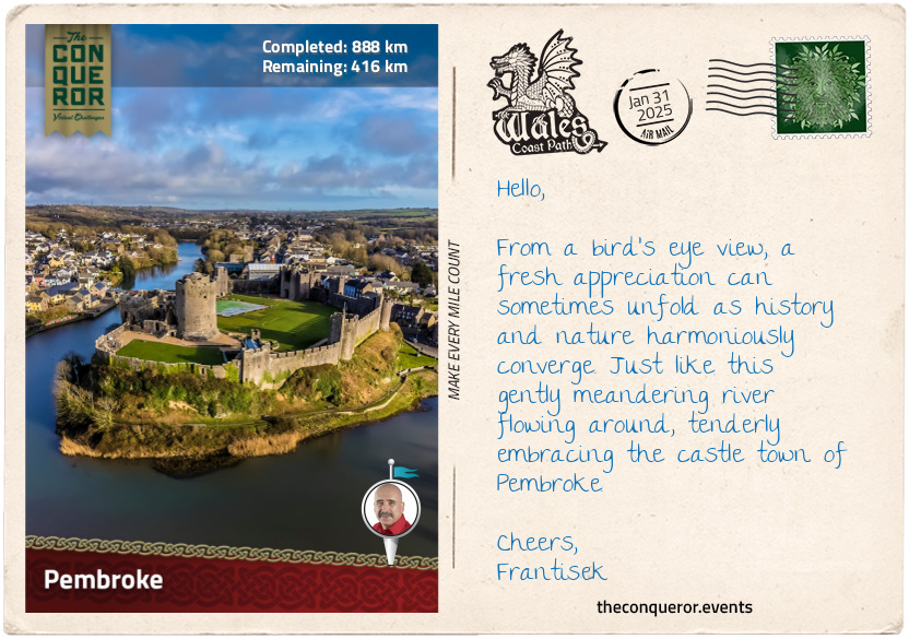
km od začátku : 0888
Pembroke
As I set foot in Pembroke, crossing the Northgate Street Bridge, I was struck by the thoughtful placement of picnic tables on the west side of the bridge, around the statue of King Henry VII, affording a stunning view of Pembroke Castle on the banks of Pembroke River. This medieval fortress, established in 1093 as a Norman motte-and-bailey castle, underwent a transformation under William Marshall. It was gifted to him by Richard the Lionheart, becoming a seat of power for the Earls of Pembroke and the birthplace of King Henry VII, founder of the Tudor dynasty.
William Marshall came from modest beginnings. Despite his noble lineage, William was the fourth son, decreasing his chance for an inheritance and leading him to find his own way. At eight, he was used as a hostage in a truce his father sought with the king. With his father breaching the truce, the king threatened to catapult William over the castle wall. Not wanting to follow through with his threat, the king imprisoned William for a few months. William began knightly training at 12, becoming a prosperous tournament champion with a reputation for chivalry and integrity. Marriage into nobility granted him the title of the 1st Earl of Pembroke.
Faithfully serving five kings in his lifetime, William's last charge was that of nine-year-old Henry III. Swearing an oath to the dying king that Henry would succeed to the throne, William, now 70 and concerned about his age, made a final promise that regardless of circumstances, he would never abandon the would-be king, proceeding to rule as a temporary regent until his death.
Passing peacefully in his sleep at 75, William was inducted into the Knights Templar order. Regarded as the 'Greatest Knight of the Middle Ages', his biography was released shortly after his death – a pioneering work chronicling the life of a regular man in the language spoken by the general public, marking a departure from biographies focused on religious figures written in scholarly languages like Latin.
After William's death, the castle passed on through a line of inheritance for the next 250 years up to 1389, when 17-year-old John Hastings died in a jousting accident without an heir. The castle changed hands many times, and during the Civil War of the 17th century, it was severely damaged. Losing its strategic and military importance, the castle was left neglected and in disrepair until the early 20th century, when efforts were made to restore and preserve it as a historical site.
I strolled down the main street and entered the local inn. Its dark forest-green façade was complemented by its rustic interior with copper pots and pans hanging from wooden beams and around a cozy open fireplace. Exuding a pleasant atmosphere, I poured over its menu. I was intrigued by the 'cockles, grilled bacon and penclawdd laverbread' as a starter. I'm told this mix of seafood (edible mollusks), smoky bacon, and the unusual flavour of laverbread (seaweed) reflect Wales' coastal heritage and traditional cuisine. I would happily follow this with a classic dish, the 'steak and Welsh ale pie'. This hearty dish consists of tender beef steak cooked in a savoury gravy infused with Welsh ale, a shortcrust base, and a flaky puff pastry top. Sounds good to me!!
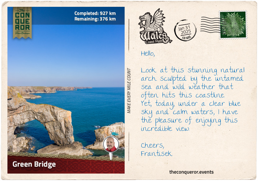
km od začátku : 0927
Green Bridge
It's a brilliant day, with blue skies and a subtle breeze brushing against my skin. I am ready to start my hike from Castlemartin. This village is mainly used as an artillery range for the British Army. Heading east to Warren, I swung south onto a narrow lane, walking past neighbouring houses until I reached a gate and passed through it. The trail seemed to be swallowed by an expanse of unruly vegetation. Thick, overgrown bushes reached out as if attempting to reclaim their territory. It felt like I was walking through a green tunnel obscuring my view of the landscape ahead.
As the grip of the thick vegetation loosened, the path opened up, giving way to expansive meadows, meticulously kept, bordered by clusters of trees far off into the distance. Arriving at a crossroads, I noticed a bilingual sign pointing to the Green Bridge of Wales. Crossing over, I ventured onto a paved pathway that cut a clear route through the countryside. Approaching a car park, I turned onto a wild field with a neatly mowed trail guiding me toward the sea. The trail ended on a viewing platform with picture-perfect views of the Green Bridge.
The Green Bridge is a limestone arch that spans a chasm, connecting the mainland to a towering rock stack. Over millions of years, the sea chipped away at the rock until the power of erosion carved caves and tunnels, forming this fabulous site. From the platform, I watched a brave soul navigating the thin, treacherous path atop the arch.
Not entirely comfortable with heights, I chose to walk past it and check out the stack rocks called Elegug Stacks, a pair of limestone pillars rising from the sea. Elegug is Welsh for guillemot, a noisy chocolate-brown seabird that lends its name to the pillars. Each spring, the tops of the stacks and the ledges below are crammed with guillemots nesting. Of course, the guillemots don't have exclusivity as they are closely joined by razorbills. Both species are descended from the extinct bird called the great auk.
I opted to rest and take in the views for some time while I planned the next part. Later, I will head to The Cauldron, a huge, expansive hollow caused by the relentless force of waves pounding against the coastal cliffs. This powerful action created a natural amphitheatre-like feature. When the sea is wild and the tide is high, I imagine the waves crashing against the rock face, splashing up as if inside a massive blowhole.
After The Cauldron, I will continue to St Govan's Head, the southernmost point of Pembrokeshire. On the way, I will take a slight detour down a steep flight of stairs to St Govan's Chapel. It is a tiny chapel amongst towering cliffs built by a hermit in the 6th century who took refuge there while hiding from pirates. Folk tales are abound in this place, but that will be a story for another day.
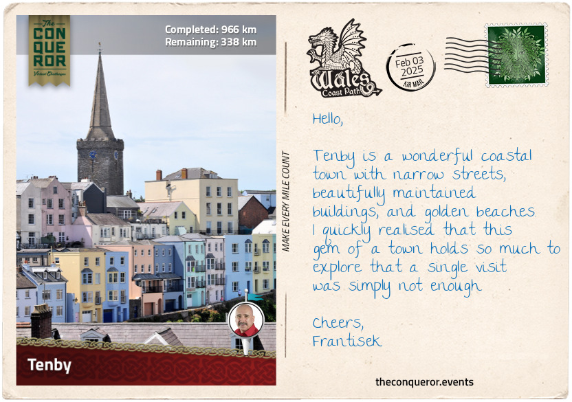
km od začátku : 0966
Tenby
Entering the town of Tenby, I was struck by the imposing St Catherine’s Fort situated on an island just off the mainland with an equally imposing sheer cliff face. Its rectangular design and solid masonry made it look forbidding as if its purpose was not only to protect the harbor but also to deter any potential threat. The fort was built in response to concerns about an amphibious invasion by the French. It was meant to be part of a chain of forts along the Pembrokeshire coast. However, only this fort was ever built, and it appears it never saw any action. The island is easily accessible from the gorgeous sandy beach during low tide.
Next, I hiked up to Castle Hill, where only a small tower of Tenby Castle remained. A manicured lawn surrounded the tower, and a bandstand stood to one side, providing shelter from the scorching sun or high winds. The views from here were fabulous, as the sea enveloped most of the hill. Gazing over the town, I was greeted by a row of pastel-coloured townhouses and a church spire stretching along the shoreline.
Leaving Castle Hill behind, I continued southeast. I followed the road downhill, the back uphill and turned onto Quay Hill, where I stopped to visit the Tudor Merchant’s House. This triple-storey stone house was built in the 15th century when Tenby was a busy commercial port. The merchant occupying the house conducted business on the lower floor, reserving the upper floors for his private residence. As the oldest house in Tenby, it was donated to the National Trust. Following restoration, the house was decorated with period furnishings and opened to the public, providing an experience of life during the Tudor era.
Inside, the main living room was adorned with painted cloths, one depicting medieval Tenby and the other featuring a ship from the Middle Ages. At the rear of the house was the kitchen with a large open fire where food would have been cooked in a cauldron. The kitchen had a table, benches, and a seat carved out from a barrel. Upstairs, in the bedchamber, was a four-poster bed and pew-like bench. The view from the window led directly to the coastline and harbour, a delightful scene to wake up to. All the furniture in the house was beautifully crafted and were locally sourced reproductions.
Tenby is a gorgeous coastal town with great beaches and a mix of medieval, Georgian and Victorian architecture. With its long maritime history, it invites deeper exploration, one that I am sure would fill many pages of writing. For now, I will indulge in a brief stroll before pressing on toward Rhossili Bay.
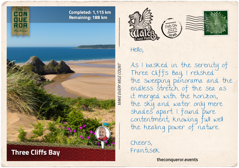
km od začátku : 1115
Three Cliffs Bay
This leg of my journey focused on the Gower Peninsula, a stretch of land that extends southwest into the Bristol Channel. Bordered by the expansive Loughor Estuary to the north and the sweeping Swansea Bay to the east, the peninsula is the UK’s first designated Area of Outstanding Natural Beauty (AONB). This special status recognises exceptional scenic beauty, and I couldn't help but appreciate the significance of this recognition.
The peninsula was a treasure trove of history, with no less than six castles scattered across its terrain. Loughor Castle, erected during the Norman conquest, stands atop a first-century Roman fort, whose remains are located beneath the town. An even older discovery occurred at Paviland Cave, where a 33,000-year-old male fossil was unearthed. Among the peninsula's landmarks are eight standing stones from the Bronze Age, including Arthur's Stone near Cefn Bryn, said to be linked to the legendary King Arthur but more likely a remnant of a Stone Age burial ground.
The trail led me past places like Penclawdd, famous for cockle harvesting, and the ruins of Weobley Castle overlooking the estuary and salt marshes. I then reached the westernmost tip of the peninsula and was greeted by the wild beauty of Rhossili Beach. Three miles (5km) of wild, surf-swept shoreline stretched before me, its golden sands framed by the steep-sided Rosshili Downs.
Venturing inland, I hiked through quaint villages and acres of farmland, eventually arriving in Oxwich, a small village known for Oxwich Castle. Constructed in the 16th century as a private residence, the castle faced disrepair by the 1940s and the threat of demolition before being saved by Cadw, the Welsh organisation devoted to preserving historic structures. Leaving the main road, I descended toward the beach, my gaze fixed on Three Cliffs Bay. The beach's compacted sand made hiking easier as I walked along its edge. The retreating sea, brought about by low tide, kept a fair distance.
Two prominent rock formations, Little Tor and Great Tor, came into view, both popular rock climbing destinations. Despite its small size, Little Tor boasted several climbing routes catering to different skill levels. Great Tor, the larger rock face, projected further into the beach and offered longer, technical routes spanning two levels. Over 40 different routes were available, though those from beach level were tide-dependent.
With the tide on my side, I walked around Great Tor, the sea breeze invigorating my senses. Soon, I found myself at the boundary separating Oxwich Beach from Three Cliffs Bay. A trio of majestic cliffs framed the bay along a pristine beach that regularly receives the sought-after Blue Flag Award.
As I stood there, waves lapping in the distance, I took my hiking boots off, rolled up my pants and bravely marched into the Irish Sea. The chilly water sent tingles down my feet as they adjusted to the cool temperature.
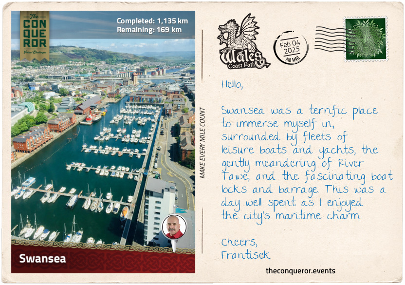
km od začátku : 1135
Swansea
After travelling most of the way through small villages, coastal towns, and seaside resorts, I had a sensory overload upon my arrival in Swansea. As the second-largest Welsh city, Swansea is an important economic hub for various industries, particularly finance, technology, education, and healthcare. The city is also home to the second-highest-ranked educational institution in Wales, Swansea University, where academic studies in engineering and technology, health and medicine, and arts and humanities are offered.
Swansea has a strong literary heritage and is closely tied to the renowned poet Dylan Thomas. Born in a house in the city's western suburbs, Thomas spent 23 years here, writing a significant portion of his published works before moving on.
The River Tawe weaved its way through the city toward the bay, flowing beneath the sleek pedestrian Sail Bridge and, a little further, the truss Trafalgar Bridge, named after the Battle of Trafalgar (c.1801).
The Trafalgar Bridge sits above a barrage constructed in 1992 to accommodate another marina. It features boat locks, spillways, fish passage and generators. The generator currently produces electricity for the National Grid and pumps water back into the river. A main concern at the time of construction was the impact on fish unable to swim upstream and the reduced oxygen in the water. To overcome this, divers installed machines that infused oxygen into the water, effectively improving the water quality. This success story extended to Cardiff, the capital city, which adopted the same measures to clean its water.
The waterfront has three marinas, where leisure crafts await their next maritime adventure. Stylish apartment complexes rise between the waterways, completing the marina development.
Strolling around the marina, I found myself at the National Waterfront Museum. It is an architectural marvel, a fusion of slate and glass that integrated a historic warehouse from the former Swansea Industrial and Maritime Museum. The museum showcases the country’s industrial journey through various exhibits, displaying items such as mining tools, textile machines, transportation relics that include a steam locomotive, and early innovations of communication devices like the telegraph machine. The museum is also a starting point for the European Route of Industrial Heritage, a tourist route focusing on Europe's most important industrial heritage sites.
My final destination was 5 Cwmdonkin Drive, the very birthplace of the renowned Welsh poet Dylan Thomas. As intrigued as I was about Thomas and his works, I was just as keen to delight in an offering of Edwardian-themed afternoon tea, where small bites of baked scones with cream and jam, Welsh cakes, and finger sandwiches graced the table along with hearty brew of Welsh tea served in antique china. Here, I could sit back, relax and envision Thomas crafting his latest pieces of literature, such as the iconic “Do Not Go Gentle into that Good Night”.
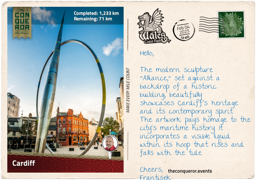
km od začátku : 1233
Cardiff
Vibrancy, modernity, and cosmopolitan flair weaved in with a long and storied history are how I would describe Cardiff, the capital city of Wales. A relatively young capital, Cardiff's official designation was in 1955, providing Wales with a definitive seat of government that was previously absent. The city's prominence came in the 19th century with the rise of the coal industry and its strategic location on the South Wales coast. Cardiff became the prime port for exporting coal. As the industry boomed, so did the city's growth and prosperity, making Cardiff one of the busiest ports in the world.
When Cardiff became a city in 1905, many important national institutions like the National Museum, National War Memorial, and Registry Building set themselves up there. Interestingly, the National Library picked Aberystwyth as its main centre because one of its founders felt Cardiff might not be Welsh enough.
When the coal industry declined, Cardiff pivoted its economy toward the financial sector, education, tourism, and services. The redevelopment of Cardiff Bay in the late 20th century rejuvenated the once-busy port. As I wandered around the waterfront, I contemplated taking a Ferris wheel ride for a scenic view from the top.
The waterfront was bustling with activity, filled with the humdrum chatter of café patrons and children squealing as they played. Amidst this scene, the Pierhead Building, with its vibrant red Victorian façade, is fabulously contrasted with the sleek modern lines of the nearby Millenium Centre, the city's iconic performance venue.
The waterfront is dotted with sculptures such as the Merchant Seaman's Memorial, a large bronze sculpture combining a sleeping head with a ship's hull, the statue of early 20th century Welsh arts performer Ivor Novello, and the Celtic Ring depicting maritime details associated with Cardiff's Docks. Cardiff is full of fascinating sculptures that any art enthusiast would thoroughly enjoy exploring by following the city's street art trail.
Bound north, I walked around the public plaza named after the endearing children's author Roald Dahl, who produced famous works such as Charlie and the Chocolate Factory, Matilda and Fantastic Mr Fox. I continued through the city centre, took a slight detour from my route, and visited Cardiff Castle for a dose of medieval history.
To capture its 2,000-year-old history would require an entire essay. Broadly speaking, the site began with a Roman fort (c.1st C), then a motte and bailey structure that overlooked the Castle Green (c.11th C), followed by stone fortifications and domestic buildings after that. The castle's transformation occurred in the 19th century when the 3rd Marquess of Bute, reputed to be the richest man in the world, began its restoration. Each room follows a theme, from Arabian-inspired decorations to a Roman-influence rooftop garden. The interior is an opulent display of richly detailed wall murals, frescoes, elaborate wood carvings, stained glass windows, gilded ceilings and more. The interior is a visual feast, filled with bold and muted colours, rich textures and delicate ornaments.
Popping into the nearby café for afternoon tea, I treated myself to a Welsh cake. This small round cake, no bigger than a saucer, looked almost like a cross between a scone, a pancake and a cookie. Where it differed was in its lovely crumbly texture.
Once finished, I will head for my final destination, Chepstow.
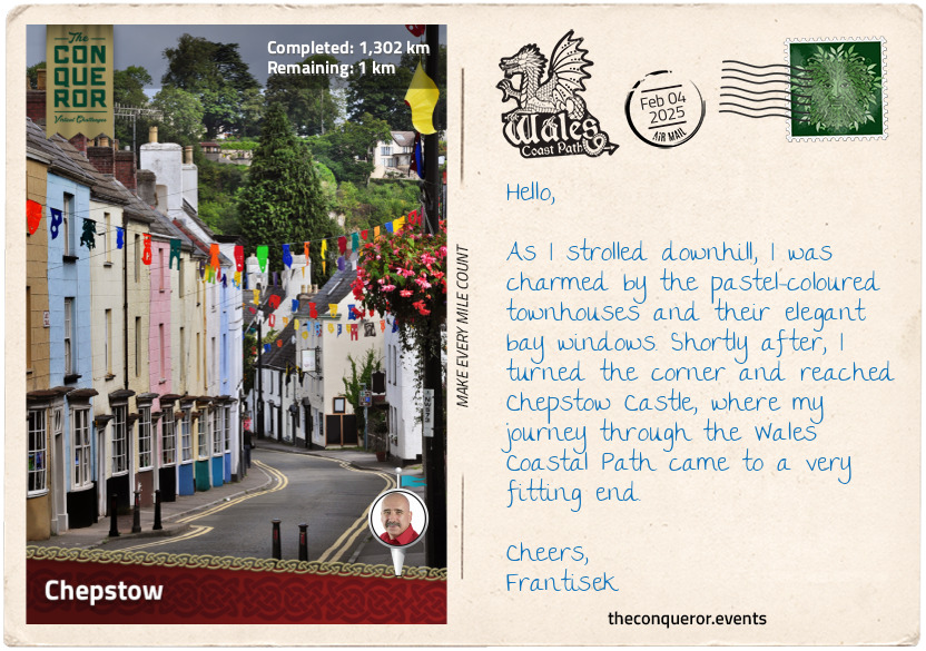
km od začátku : 1302
Chepstow
With a sense of finality, I arrived in Chepstow, the easternmost settlement in Wales, near the border of England. It is located on the doorstep of the Wye Valley, an Area of Outstanding Natural Beauty (AONB), and on the bend of the meandering River Wye. This marked the culmination of my Wales Coastal Path adventure. As I strolled through the town's narrow streets, I felt a deep sense of accomplishment, knowing that I had traversed the coastal landscapes of Wales to reach this destination.
The pleasant facades of the buildings in the town centre were a blend of Georgian townhouses and timber-framed structures. Large pots of greenery decorated the sidewalks while floral baskets dangled outside the local inn, offering a burst of summer colour.
Squeezed tightly between two buildings was the reconstructed 16th-century Town Gate. Only a stone's throw away were traces of the Port Wall, a defensive wall that once encircled the town and linked up with Chepstow Castle. Governed by a noble lord, taxes were imposed on the users of the town's market. To ensure payment of required tolls, the lord oversaw the construction of the wall and the Town Gate, serving as the sole entry point, becoming an essential part of this arrangement.
Once through the gate, I walked by the Castle Terrace, a delightful row of fourteen three-storied townhouses that backed onto Chepstow Castle. It was constructed in the early 1800s by unknown builders at a time when Chepstow was a thriving port town exporting timber. A unique building feature was the single front bay window on each townhouse, except for a few, creating a charming uniform look as I went downhill.
Rounding the corner behind the townhouses, I arrived at Chepstow Castle. It was built in 1067, making it Britain's oldest surviving stone castle. Perched on the cliff's edge, the layout is long and narrow, designed to fit onto a thin ridge between the valley and the river cliff. The castle's original wooden doors were groundbreaking, being the first time they were fortified with iron plates to withstand battery and fire. Currently on display inside the castle, the doors, at more than 800 years old, are recognised as the oldest in Europe.
This is the end of my journey, and as I ponder and reflect on Wales' identity, culture and diverse history, I am reminded of the Welshman's words I mentioned in the beginning, who also said, "…Wales is defined by its persistence more than anything else… it remains distinct in language, customs, folklore…" and then he aptly capped it off with this popular Welsh saying "Ry'n ni yma o hyd" which means "we're still here". Yes indeed.